Typhoon Dolphin Nears China: 1 Million Evacuated, 500mm Rain Threat — Chan-Hom Near Japan
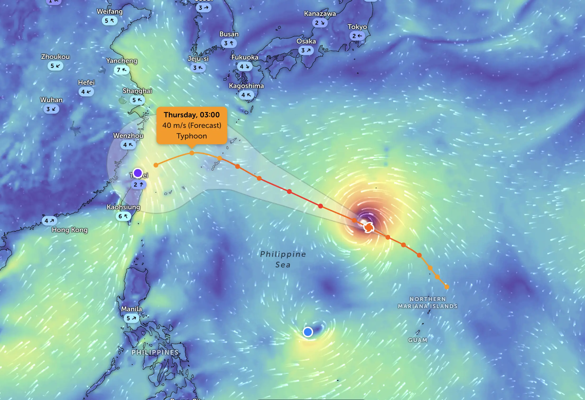
Typhoon Dolphin is the most urgent tropical cyclone threat in the western Pacific on August 9, 2026. The storm is approaching China’s east coast after passing Okinawa, with more than one million people moved to safety, major flight disruption in Shanghai and a serious risk of extreme rainfall, flooding and landslides across Zhejiang and neighboring provinces. Farther east, Tropical Cyclone Chan-Hom remains over the Pacific southeast of Japan and is still being monitored for a possible approach toward the country.
Typhoon update — August 9:
- Dolphin: the primary near-term threat, approaching eastern China after affecting Okinawa.
- China landfall: forecasters expect Dolphin to cross the Zhejiang / northern Fujian sector before weakening inland.
- Rainfall: parts of central and eastern Zhejiang could receive 250–500 mm of rain.
- Evacuations: more than 1 million people have been moved to safety across eastern China.
- Shanghai: mass flight cancellations and port restrictions are already disrupting travel and shipping.
- Chan-Hom: lower immediate risk, but its west-northwest track toward Japan still requires monitoring.
- Main danger: Dolphin’s wind field should weaken after landfall, but flooding and landslide risk can remain severe well after the center moves inland.
Typhoon Dolphin 2026: China Landfall and Flood Risk
Dolphin has weakened substantially from its earlier super-typhoon phase, but that does not mean the dangerous part of the storm is over. The threat is increasingly shifting from peak wind intensity toward torrential rain, river flooding, flash floods, landslides, coastal flooding and transport disruption.
China’s National Meteorological Center expects Dolphin to make landfall on the east coast before moving inland and gradually weakening. Reuters reported that the storm could reach the coast with sustained winds up to about 162 km/h, while the heaviest rainfall may continue through August 10.
Up to 500mm of Rain: Zhejiang Is the Highest-Risk Area
Central and eastern Zhejiang are facing the most dangerous rainfall signal. Forecast totals of 250–500 mm are enough to produce severe flash flooding, swollen rivers, mountain torrents and landslides, especially where rainbands repeatedly cross the same terrain.
Heavy rain is also expected across Shanghai, northern Fujian, northeastern Jiangxi, central and southern Anhui and much of Jiangsu. Flood danger may continue after Dolphin weakens below typhoon strength.
More Than 1 Million Evacuated as Shanghai Cancels Flights
Eastern China has launched a large emergency response ahead of Dolphin. More than one million people have been moved to safer locations. Wenzhou alone relocated more than 900,000 residents and opened over 1,000 emergency shelters.
Shanghai has evacuated residents from high-risk areas and canceled a large share of flights at Pudong and Hongqiao airports. Maritime authorities also cleared ships from Yangshan port and moved hundreds of vessels to shelter.
Typhoon Dolphin Track: What Happens After Landfall?
Most likely scenario: Dolphin crosses the east coast of China, weakens rapidly over land and loses its destructive inner wind core. However, deep tropical moisture should continue moving inland, extending the flood threat into eastern and central China.
| Period | Most likely storm phase | Main area of concern | Primary hazards |
|---|---|---|---|
| August 9 | Typhoon approaching / crossing eastern China coast | Zhejiang, northern Fujian, Shanghai coastal sector | Damaging winds, extreme rain, storm surge, high waves |
| August 9 night | Landfall and rapid weakening | Interior Zhejiang and adjacent provinces | Flash flooding, landslides, river flooding, strong gusts |
| August 10 | Tropical storm / depression stage inland | Jiangxi, Anhui, Jiangsu and nearby areas | Heavy rain, swollen rivers, slope failures |
| August 10–11 | Weakening remnant circulation | Eastern and central China | Persistent rainfall and delayed flooding |
| By August 11 | Dissipating tropical circulation | Inland China | Localized residual flooding |
Confidence: High for rapid weakening after landfall and continued heavy rainfall. Confidence is lower for exact local rainfall maxima because tropical rainbands can shift by tens of kilometers.
Will Typhoon Dolphin Affect Shanghai?
Yes. Shanghai is not necessarily the core landfall point, but the city is already experiencing major indirect impacts. Flight cancellations, port restrictions, strong winds and heavy rain are affecting the metropolitan area. The exact rainfall distribution will depend on the final track and the position of Dolphin’s outer rainbands.
Shanghai residents should continue following local flood, wind and transport warnings even if the typhoon center passes south of the city.
Chan-Hom 2026: Is the Cyclone Heading Toward Japan?
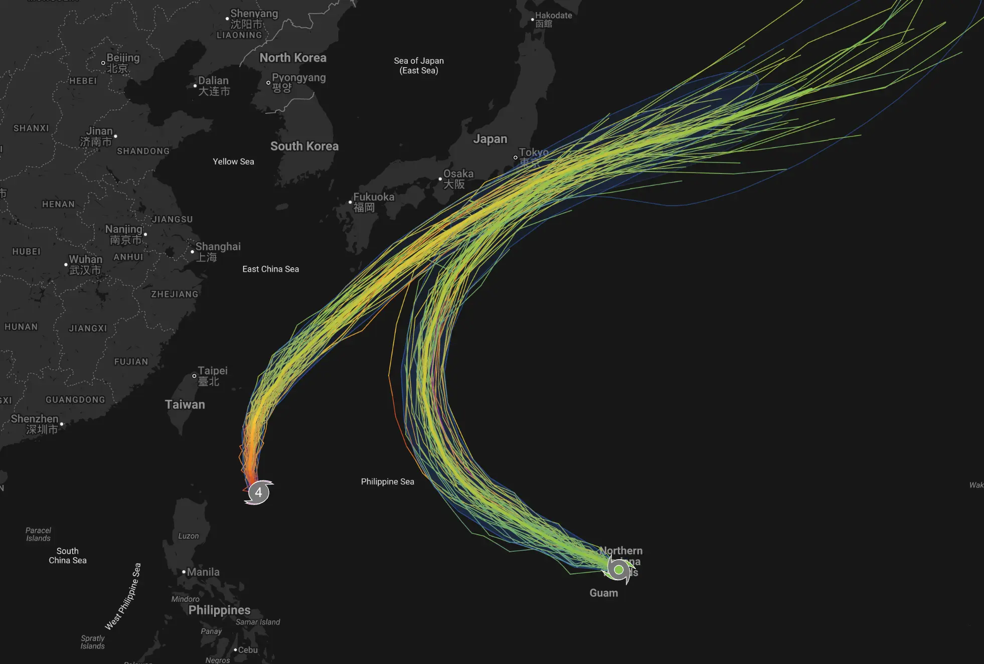
Chan-Hom is the secondary tropical system to monitor. The consolidated JTWC/NASA assessment for August 9 placed it over the western North Pacific, southeast of Japan, with tropical-storm strength winds. Unlike Dolphin, Chan-Hom has shown a less straightforward intensity trend, weakening and then reorganizing.
Dolphin
Risk level: High
Near-term focus: Eastern China
Main danger: Flooding, landslides, coastal impacts and wind
Trend: Rapid weakening after landfall, but rainfall remains dangerous
Chan-Hom
Risk level: Moderate
Near-term focus: Waters east / northeast of Japan
Main danger: Rough seas, gale-force winds, squalls and locally heavy rain
Trend: Possible short-term reorganization, then weakening and subtropical transition
Chan-Hom Forecast Through August 12
The source assessment indicates a generally west-northwest track toward Japan, followed by weakening at higher latitudes and a transition toward a broader subtropical or extratropical-type system.
| Valid period | Expected evolution | Main uncertainty |
|---|---|---|
| August 9–10 | West to northwest movement across the western Pacific; tropical-storm intensity may fluctuate | How much short-term strengthening occurs |
| August 10–11 | Closer approach to eastern or northeastern Japan | How far west the track extends toward the Japanese coast |
| August 11–12 | Weakening and likely subtropical transition | Exact timing and location of transition |
A farther-west track would increase rain, wind and wave impacts for eastern and northern Japan. A farther-east track would keep the strongest conditions offshore. Confidence: Moderate.
How Pogodnik Builds the Cyclone Risk Assessment
Forecast priority: JTWC / JMA / national meteorological agencies → NOAA and NASA satellite observations → conventional numerical and AI ensemble guidance → GDACS and RSOE impact monitoring.
High confidence: official agencies and model ensembles broadly agree.
Moderate confidence: the official scenario is clear, but meaningful spread remains in track, intensity or timing.
Low confidence: major disagreement exists between official forecasts or ensemble scenarios.
Why a Weakening Typhoon Can Still Be Deadly
Wind speed often falls quickly after landfall, but tropical moisture can remain concentrated over the same region for many hours. Mountains force moist air upward, intensifying rainfall and increasing the risk of landslides and debris flows.
This is why Dolphin’s most dangerous phase may continue after it is downgraded. Residents should not treat a downgrade from typhoon to tropical storm or depression as an all-clear if flood and landslide warnings remain active.
Track Local Rain, Wind and Pressure with Pogodnik
The Pogodnik Weather Forecaster provides hourly temperature, precipitation, wind and atmospheric-pressure forecasts for locations worldwide. During a typhoon, use local Pogodnik forecasts together with official evacuation orders and warnings from national meteorological and emergency agencies.
Related Typhoon Forecasts
- Pogodnik Typhoon Forecast Archive
- Typhoon Noul 2026: China Landfall and Cities at Risk
- Typhoon Jangmi Forecast: Japan Track and Spaghetti Models
Typhoon Dolphin and Chan-Hom FAQ
Where is Typhoon Dolphin heading?
Dolphin is moving toward eastern China, with Zhejiang and northern Fujian in the main landfall-risk corridor. Heavy rain also threatens Shanghai and several inland provinces.
When will Typhoon Dolphin make landfall in China?
Landfall is expected on August 9 along China’s east coast. Exact timing and the final coastal crossing point can still shift.
How much rain could Typhoon Dolphin bring?
Parts of central and eastern Zhejiang could receive 250–500 mm of rain, with severe flash-flood and landslide risk.
Will Typhoon Dolphin hit Shanghai?
Shanghai is already seeing major indirect impacts, including flight cancellations, strong winds and heavy rain. The typhoon center may pass south of the city, but outer rainbands can still produce serious disruption.
Why are so many people being evacuated?
The combined threat from extreme rainfall, mountain torrents, landslides, coastal flooding and strong winds makes early evacuation safer than waiting for conditions to deteriorate.
Is Chan-Hom heading toward Japan?
The broad forecast takes Chan-Hom west-northwest toward waters closer to Japan before weakening and transitioning. The exact westward extent remains uncertain.
Which storm is more dangerous right now?
Dolphin is the more urgent threat because it is approaching a densely populated part of eastern China and carries a major flood and landslide risk. Chan-Hom remains a lower but still meaningful marine and Japan-adjacent threat.
What is the best typhoon tracker?
For life-safety decisions, use official JTWC, JMA and national meteorological warnings first. Satellite products from NOAA and NASA, ensemble guidance and disaster-monitoring systems are useful additional layers.