Typhoon Noul Is Strengthening Fast: Guangdong–Fujian Landfall Threat, Extreme Rain and Cities in the Path
Tropical Cyclone Noul is rapidly strengthening after crossing the far north of the Philippines and is now heading toward the northeastern South China Sea. The storm — called Kiyapo in the Philippines and Hongxia in China — is forecast to become a typhoon before approaching the coast of southern China. The official landfall corridor remains unusually broad, stretching from Zhuhai in Guangdong to Zhangpu in Fujian, but the latest forecast coordinates currently place the centreline closest to the eastern Guangdong coast. Residents from Batanes and northern Cagayan to Hong Kong, Macao, Shenzhen, Shanwei, Shantou, Xiamen and Zhangzhou should prepare for worsening wind, dangerous seas, torrential rain, flooding and possible landslides.
Tropical Cyclone Noul: the most important warning points
- Current situation: Noul crossed the coastal waters around Camiguin Island and Calayan in far northern Luzon on July 24, bringing gale-force winds and heavy rain.
- Track: The storm is moving west to west-northwest through the Luzon Strait, then is expected to turn northwest toward southeastern China.
- Peak intensity: Operational forecasts support typhoon-strength winds before landfall. The Hong Kong Observatory forecast a peak near 130 km/h, while China’s National Meteorological Center allowed for roughly 119–144 km/h at landfall.
- Experimental high-end forecast: Google DeepMind and COAMPS-TC guidance has indicated a possible peak near 155–165 km/h. This is not an official warning and should be treated as a higher-impact scenario.
- Landfall window: Saturday night, July 25, through early Sunday, July 26.
- Landfall corridor: From Zhuhai, Guangdong, to Zhangpu, Fujian. The latest centreline leans toward eastern Guangdong, but a shift of 100–200 km would substantially change the cities facing the strongest winds.
- Rainfall threat: Eastern Guangdong, southern Fujian and southern Jiangxi may receive 150–300 mm, locally 400–450 mm. Some forecasts warn that isolated totals could approach 500–600 mm.
- Main dangers: Flash flooding, river flooding, landslides, destructive gusts, coastal flooding, high waves, transport shutdowns and prolonged power outages.
Last updated: July 24, 2026, 16:30 Hong Kong/China Standard Time. Tropical cyclone forecasts can change quickly. Follow your national and local meteorological agency for official warnings and evacuation instructions.

What is Tropical Cyclone Noul, Kiyapo or Hongxia?
The same storm is appearing under several names in current searches and warnings:
- Noul is the international name used across the western North Pacific.
- Kiyapo is the local Philippine name assigned by PAGASA.
- Hongxia is the name used in China, where the system is also identified as Typhoon No. 12 of 2026.
That is why searches such as Typhoon Noul 2026, Noul path, Kiyapo update, Hongxia typhoon, Typhoon 12 China and Noul live tracker all refer to the same tropical cyclone.
Latest Tropical Storm Noul position and strength
PAGASA reported during the afternoon of July 24 that Kiyapo/Noul was over the coastal waters around Camiguin Island in the Calayan municipality of Cagayan. It was moving west-northwest at approximately 25 km/h, with maximum sustained winds near 75 km/h and gusts near 90 km/h.
The Hong Kong Observatory classified Noul as a severe tropical storm at 11:00 HKT, with sustained winds near 90 km/h. Different agencies can publish different wind values because they use different observation times, averaging periods and classification systems.
| Agency or model | Latest available signal | Forecast interpretation |
|---|---|---|
| PAGASA | 75 km/h sustained winds, gusts to 90 km/h near Calayan | Direct wind and rain impacts across Batanes, Babuyan Islands and northern Luzon |
| Hong Kong Observatory | Severe tropical storm; 90 km/h at 11:00 HKT | Forecast to reach around 130 km/h over the northeastern South China Sea |
| China NMC/CMA | Rapid strengthening toward the Guangdong–Fujian coast | Possible landfall winds of about 33–40 m/s, or 119–144 km/h |
| Korea Meteorological Administration | Forecast peak around 126 km/h | Typhoon-strength system approaching eastern Guangdong |
| Google DeepMind / COAMPS-TC | Experimental high-end peak near 155–165 km/h | A more dangerous intensity scenario, not an official public warning |
Where is Typhoon Noul heading?
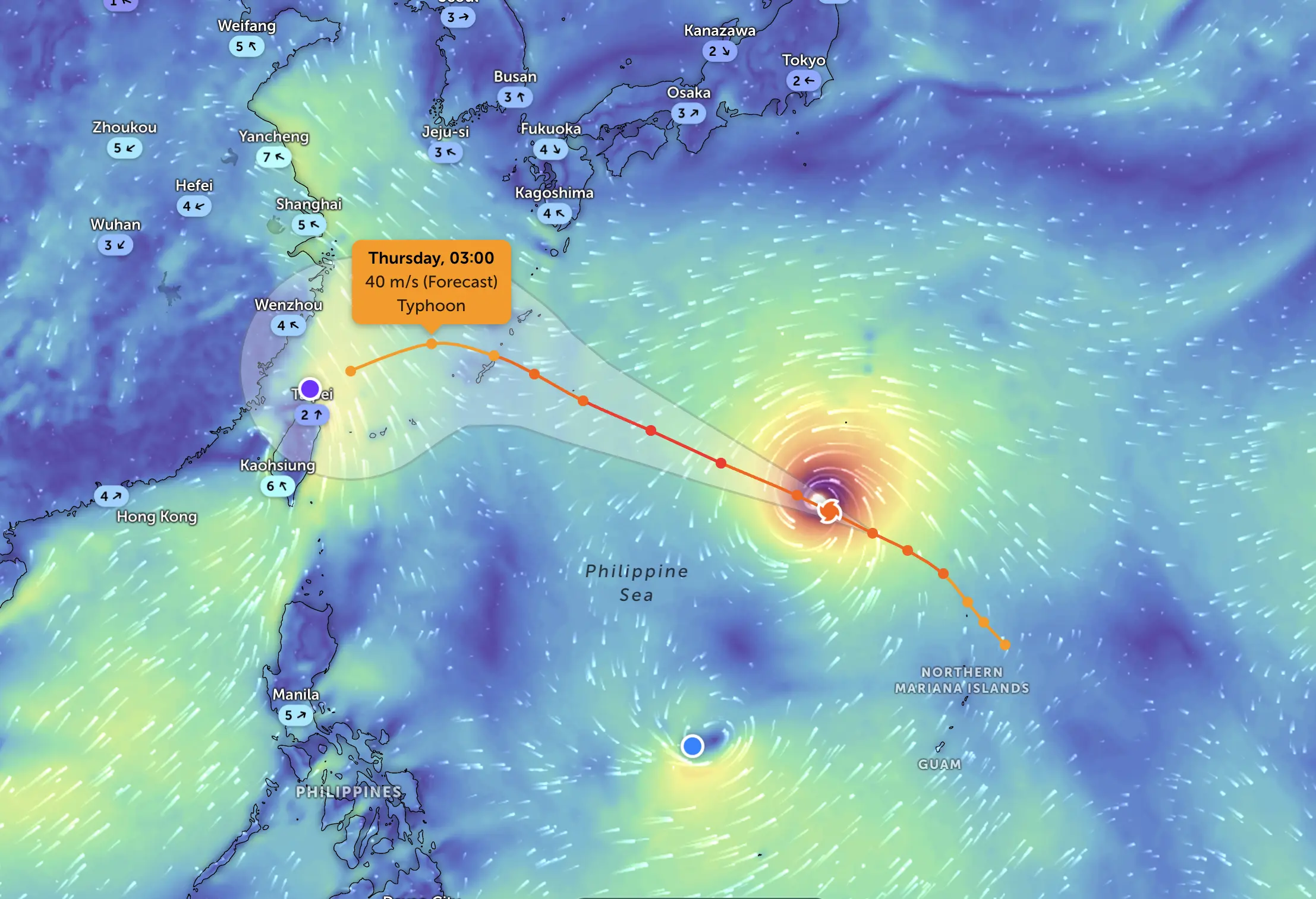
The consensus track takes Noul westward through the Luzon Strait, then northwest across the northeastern South China Sea. A subtropical ridge south of Japan is steering the cyclone toward southeastern China. As Noul reaches the western edge of that ridge, it is expected to turn more poleward and move inland through Guangdong toward Jiangxi and possibly Hunan.
Noul path and timing
- Friday, July 24: Crossing extreme northern Luzon and the Luzon Strait; stormy conditions in Batanes, Babuyan Islands, northern Cagayan and northern Ilocos Norte.
- Late Friday into Saturday, July 25: Entering the northeastern South China Sea and strengthening, potentially reaching typhoon intensity.
- Saturday night into early Sunday, July 26: Expected landfall somewhere between Zhuhai in Guangdong and Zhangpu in Fujian.
- Sunday, July 26: Rapid weakening over land, but torrential rain spreading through Guangdong and toward southern Jiangxi.
- Monday, July 27: Remnants moving north-northwest through Jiangxi or toward Hunan, with continued flood and landslide risk.
Based on the latest forecast coordinates, the centreline currently points toward the Shanwei–eastern Guangdong sector. This is an inference from the forecast track, not a final landfall declaration. The official cone remains wide enough to include the Pearl River Delta to the west and southern Fujian to the east.

Which cities could be affected by Tropical Cyclone Noul?
Not every city listed below will receive the eyewall or the strongest winds. The storm’s damaging wind core may be much narrower than its rain shield, and a small track shift could move the highest-impact corridor by more than 100 kilometres.
Extreme Northern Philippines: direct impacts already underway
The greatest direct Philippine wind risk is concentrated across Batanes, the Babuyan Islands, northern Cagayan, northern Apayao and northern Ilocos Norte.
Places requiring close attention include:
- Calayan and Camiguin Island — close to the storm’s July 24 passage;
- Basco and Itbayat in Batanes;
- Aparri, Santa Ana, Gonzaga, Claveria, Ballesteros, Buguey and Lal-lo in Cagayan;
- Pagudpud, Bangui, Burgos and Vintar in Ilocos Norte;
- upland and landslide-prone areas of northern Apayao and the Cordillera.
PAGASA warned of minor to moderate damage from gale-force winds in areas under Tropical Cyclone Wind Signal No. 2. Heavy rain may trigger flooding and landslides, especially in northern Cagayan and Ilocos Norte.
Metro Manila and western Philippines: indirect monsoon impacts
Metro Manila is not in the projected core track. However, Noul is enhancing the southwest monsoon. Periods of rain may affect Metro Manila, Zambales, Bataan, Bulacan, Cavite, Batangas, Pangasinan, Occidental Mindoro, Palawan and parts of Western Visayas through Saturday.
The main threat away from the cyclone centre is local flooding from repeated monsoon rain rather than typhoon-force winds.
Hong Kong and Macao: outer-core wind, squalls and travel disruption
Under the current track, Hong Kong and Macao are more likely to remain on the western or southwestern side of Noul than to take a direct eyewall strike. Even so, the storm is expected to move close enough to strengthen winds, generate high waves and bring squally showers and thunderstorms.
The Hong Kong Observatory planned to issue the Standby Signal No. 1 on Friday evening and assess whether a higher signal would be required as Noul entered the South China Sea. Residents should watch for rapid warning changes on Saturday because the final risk depends on how far west the centre tracks.
For Macao, the greatest concern is a possible westward shift toward Zhuhai and the Pearl River Estuary. Marine transport, bridge services and outdoor events may be restricted if local cyclone signals rise.
Pearl River Delta: Zhuhai, Shenzhen, Hong Kong, Macao and Huizhou
Zhuhai marks the western edge of the official landfall corridor. A direct approach toward the Pearl River Delta would increase the wind and coastal-flood risk for Zhuhai, Macao, Shenzhen, Hong Kong and Huizhou.
Even if the centre passes east of the delta, outer rainbands may still cause:
- squally showers and thunderstorms;
- strong winds offshore and on exposed high ground;
- dangerous swells and rough seas;
- ferry, rail and flight disruption;
- urban flooding in intense rainbands.
Eastern Guangdong: highest current landfall concern
The latest centreline gives the greatest current concern to the eastern Guangdong coast, although uncertainty remains high.
Cities and counties that should prepare include:
- Shanwei, Haifeng and Lufeng;
- Huizhou and Huidong;
- Shantou, Jieyang and Chaozhou;
- Meizhou and Heyuan as the cyclone weakens inland.
Eastern Guangdong may face the most dangerous combination of typhoon-force winds, extreme rain, coastal flooding and landslides. Mountain valleys and small river basins can respond rapidly if rainfall totals exceed 300 mm.
Southern Fujian: Zhangzhou, Xiamen and surrounding districts
The eastern end of the official landfall corridor reaches Zhangpu County in Zhangzhou. A farther-north or more easterly track would increase the risk to:
- Zhangzhou and Zhangpu;
- Xiamen;
- Longyan;
- southern parts of Quanzhou;
- mountainous districts vulnerable to landslides and debris flows.
Southern Fujian could receive extreme orographic rainfall even if the centre makes landfall in Guangdong. The strongest rain may fall north and east of the exact crossing point, depending on the storm’s structure and moisture flow.
Southern Jiangxi and Hunan: dangerous rain after landfall
Noul will weaken rapidly once inland, but a weaker cyclone can still produce life-threatening rain. Southern Jiangxi is forecast to receive major rainfall as the remnants move northward.
Residents around Ganzhou, Ji’an and Pingxiang should monitor flood and landslide warnings. If the remnant circulation continues toward Hunan, heavy rain could later affect Chenzhou, Hengyang and areas toward Changsha.
How strong could Typhoon Noul become before landfall?
The operational model consensus supports continued strengthening over warm water in the Philippine Sea and northeastern South China Sea. The Hong Kong Observatory forecast Noul to reach approximately 130 km/h near the centre on Saturday, while China’s NMC projected typhoon-level landfall winds of approximately 119–144 km/h.
The Google DeepMind Weather Lab and COAMPS-TC have produced a stronger high-end scenario, with a peak near 155–165 km/h. Weather Lab generates multiple experimental AI scenarios for cyclone track and intensity, but Google explicitly warns that these products are not official weather reports or public warnings.
Do not prepare only for the current wind speed.Noul is expected to strengthen after leaving the rugged islands of northern Luzon and moving over the warm South China Sea. Coastal communities should prepare for the forecast landfall intensity, not the weaker intensity observed earlier on July 24.
How much rain could Noul bring?
China’s early official guidance indicates accumulated rainfall of approximately 150–300 mm across eastern Guangdong, southern Fujian and southern Jiangxi, with local totals of 400–450 mm.
Other meteorological estimates warn that isolated totals may reach 500–600 mm. Such rainfall would be capable of producing severe flash floods, river rises, landslides, debris flows and urban drainage failure.
| Area | Expected main hazard | Highest-risk period |
|---|---|---|
| Batanes, Babuyan Islands and northern Cagayan | Gale-force winds, heavy rain, rough seas and landslides | Friday, July 24 |
| Hong Kong, Macao and Pearl River Delta | Squalls, strong winds, high waves, urban flooding and travel disruption | Saturday into Sunday |
| Eastern Guangdong | Typhoon-force winds, extreme rain, flash floods, coastal flooding and landslides | Saturday night through Sunday |
| Southern Fujian | Torrential rain, strong winds, river flooding and mountain landslides | Saturday night through Sunday |
| Southern Jiangxi and parts of Hunan | Prolonged inland rain, flash floods and debris flows | Sunday through Monday |
Transport disruption: ferries, trains and flights
Travel disruption is expected to expand as Noul approaches China.
- Guangdong authorities announced rail suspensions beginning Saturday, with broader high-speed and conventional rail shutdowns expected on Sunday.
- Zhuhai planned to suspend ferry services for Saturday and Sunday and close coastal scenic areas.
- Hong Kong and Macao ferry operations may be restricted as cyclone signals and sea conditions worsen.
- Flights serving Hong Kong, Shenzhen, Zhuhai, Shantou and Xiamen may be delayed, diverted or cancelled.
- Sea travel around Batanes, the Babuyan Channel and the northeastern South China Sea is dangerous.
Passengers should check directly with airlines, railway operators, ferry companies and airport authorities before leaving home.
What residents should do now
For northern Philippines
- Follow the latest PAGASA Tropical Cyclone Wind Signals and municipal evacuation orders.
- Do not travel by small boat or cross exposed coastal waters.
- Secure roofs, windows, livestock areas and loose outdoor objects.
- Move away from steep slopes, riverbanks and known flash-flood channels.
- Expect road closures and power interruptions in Batanes, Babuyan Islands and northern Cagayan.
For Guangdong and southern Fujian
- Prepare for power and mobile-network interruptions lasting beyond the landfall period.
- Charge phones and power banks and store drinking water, medication and ready-to-eat food.
- Move vehicles out of underground or flood-prone parking areas.
- Clear drains and secure signs, awnings, balcony furniture and construction materials.
- Leave coastal, island, low-lying and landslide-prone areas when instructed by local authorities.
- Do not enter flooded roads. Water depth and road damage can be impossible to judge.
For Hong Kong and Macao
- Monitor HKO and SMG cyclone signals rather than relying on social-media track maps.
- Avoid shorelines, piers, breakwaters and water sports as swells increase.
- Prepare for ferry and bridge-service changes.
- Check windows, drains and loose objects before local winds strengthen.
- People living in low-lying coastal districts should prepare for water ingress if heavy rain coincides with high tide.
For inland Guangdong, Jiangxi and Hunan
- Do not assume the danger ends after landfall.
- Mountain communities should watch for cracks, falling stones, unusual stream changes and official landslide alerts.
- Move away from small rivers and narrow valleys before night-time torrential rain begins.
- Keep vehicles away from underpasses and roads beside steep slopes.
How reliable is the current Noul path forecast?
Confidence is relatively high that Noul will move through the Luzon Strait, strengthen over the northeastern South China Sea and reach southeastern China. Confidence is lower regarding the exact landfall point and peak intensity.
A 100-km shift west would raise the threat to Zhuhai, Shenzhen, Hong Kong and Macao. A shift east would increase the risk to Shantou, Chaozhou, Xiamen and Zhangzhou. The latest centreline currently points toward eastern Guangdong, but residents across the full official corridor should remain prepared.
The Google DeepMind AI track lies on the southern side of some guidance, while other models turn the storm northward sooner. This spread is why the official forecast cone — not one individual model line — should guide emergency planning.
Noul live tracker and official updates
For life-safety decisions, use official national and local agencies first:
- PAGASA Tropical Cyclone Bulletins for the Philippines;
- Hong Kong Observatory Tropical Cyclone Position;
- China National Meteorological Center typhoon bulletin;
For more western Pacific cyclone coverage, see the Pogodnik typhoon forecast archive and the recent analysis of Typhoon Jangmi and model-track uncertainty near Japan.
Track local rain, wind and pressure with Pogodnik
The Pogodnik Weather Forecaster app provides hourly weather, rain, wind, pressure and local forecasts. During a tropical cyclone, always use the app together with official warnings from PAGASA, HKO, SMG or China’s NMC.
Tropical Cyclone Noul FAQ
Where is Typhoon Noul now?
During the afternoon of July 24, Noul/Kiyapo was crossing the coastal waters around the Calayan island group in far northern Luzon and moving toward the Luzon Strait.
Where will Typhoon Noul make landfall?
The official China landfall corridor extends from Zhuhai in Guangdong to Zhangpu in Fujian. The latest forecast centreline currently leans toward eastern Guangdong, but this may still change.
When will Noul hit China?
Landfall is forecast between Saturday night, July 25, and early Sunday morning, July 26.
Will Noul hit Hong Kong?
A direct hit is not the leading scenario at this update, but Hong Kong may experience strengthening winds, squally showers, thunderstorms, high waves and transport disruption. A westward track shift would increase the risk significantly.
Will Noul affect Macao?
Macao may receive strong outer rainbands, gusty winds and rough seas. The local risk will increase if the centre tracks toward Zhuhai or the western Pearl River Estuary.
Which Chinese cities are most at risk?
Residents in Zhuhai, Shenzhen, Huizhou, Shanwei, Shantou, Jieyang, Chaozhou, Zhangzhou and Xiamen should closely monitor updates. Inland flood risk may later spread toward Heyuan, Meizhou, Ganzhou and other parts of southern Jiangxi.
How strong could Noul become?
Operational forecasts support typhoon-strength winds, roughly 120–145 km/h near peak or landfall. Experimental DeepMind and COAMPS-TC guidance has shown a higher-end scenario near 155–165 km/h.
How much rain could fall?
Eastern Guangdong, southern Fujian and southern Jiangxi may receive 150–300 mm, locally 400–450 mm. Isolated worst-case totals could approach 500–600 mm.
Is Google DeepMind Weather Lab an official warning service?
No. Weather Lab provides experimental AI cyclone scenarios. Official evacuation and warning decisions must come from national and local meteorological and emergency agencies.