Japan Weather Warning: Tokyo, Yokohama and Kanto Face Extreme Rain Signal on September 7
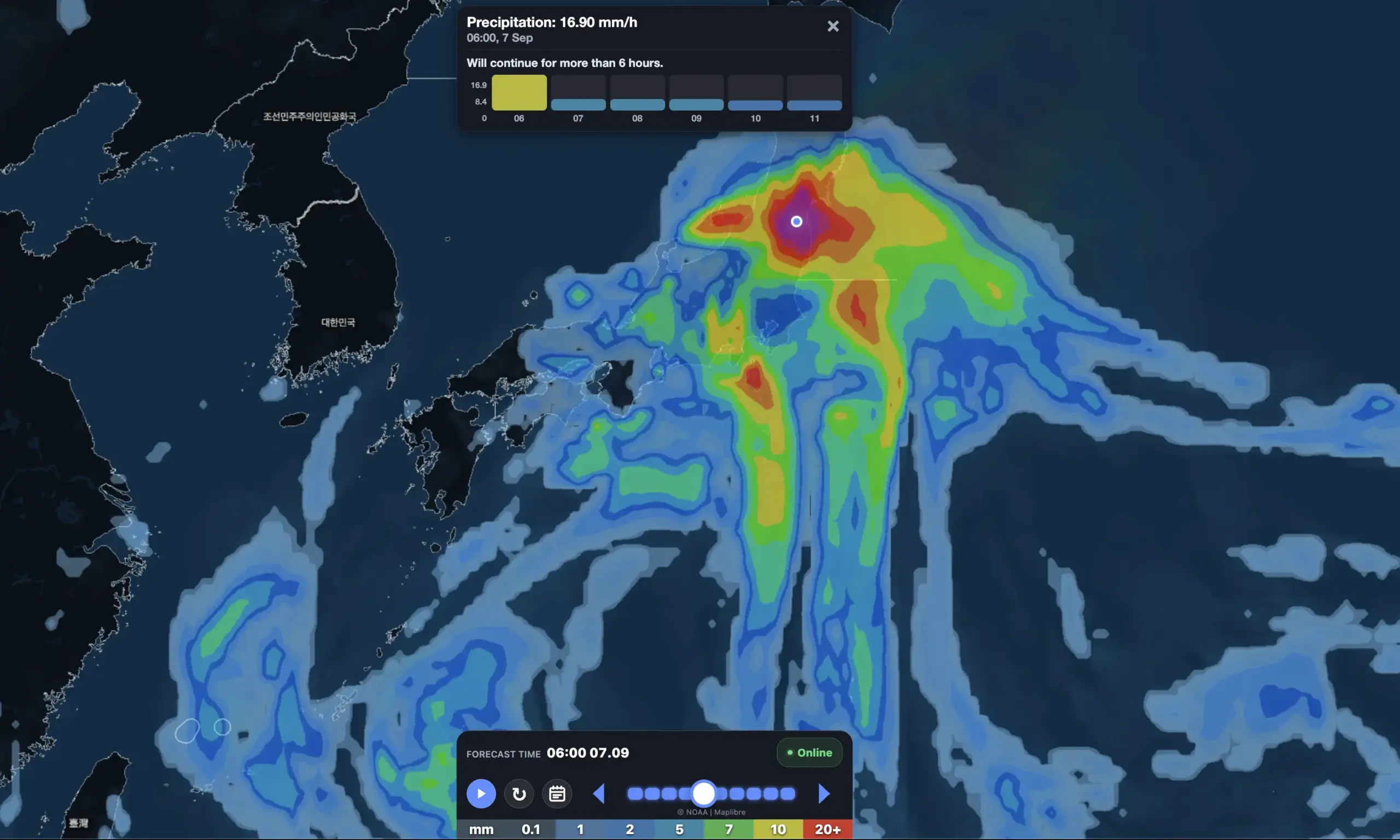
This is no longer a single-city model spike. The new Weather Forecaster forecast still shows around 310 mm of precipitation in Tokyo on September 7 — and the same extreme signal now stretches across a large part of Kanto. Yokohama is even higher at nearly 383 mm, while Saitama, Chiba and Ibaraki approach or exceed 190–200 mm.
That changes the story.
The main Japan weather threat for the beginning of the new week is no longer simply Typhoon No. 24 Krovanh. The bigger concern is a multi-system setup: Krovanh loops around Okinawa, another tropical depression moves north south of Honshu, and both systems continue feeding warm tropical moisture into a stalled autumn rain front — 秋雨前線.
Weathernews now independently warns that the front may become active again on Sunday, September 6 and Monday, September 7, with heavy rain expanding into Kanto and the Pacific side of Tohoku. It specifically notes that areas affected by the major August rainfall in Chiba could again receive heavy rain.
The exact 300–380 mm city totals are Weather Forecaster model signals, not official JMA rainfall warnings. But because the signal survives another model run and appears across multiple neighboring grid points, it deserves serious attention.
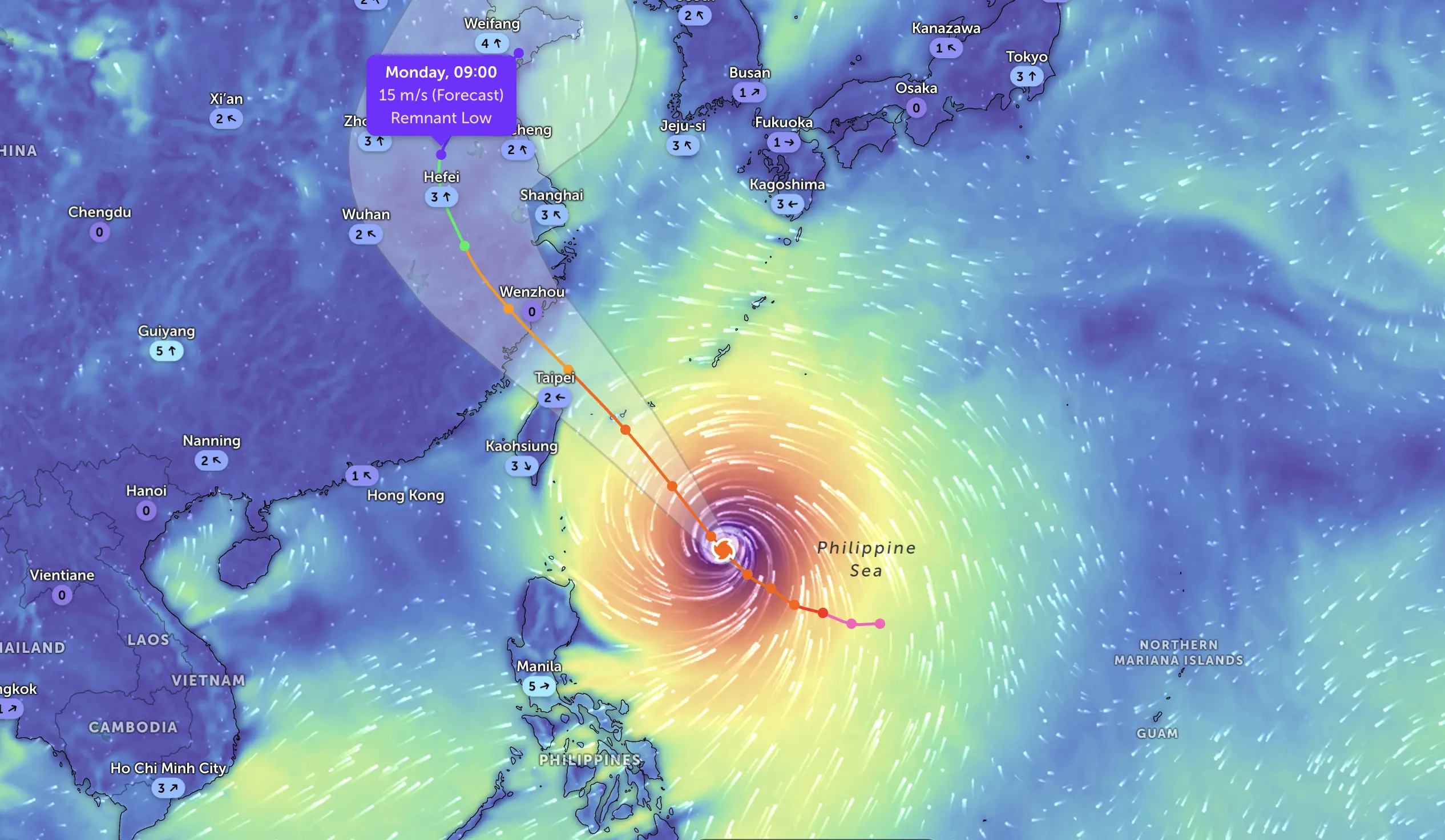
Typhoon No. 24 track: Krovanh loops around Okinawa, then turns back toward Japan
At 12 PM JST on September 5, Typhoon No. 24 was about 90 km north-northeast of Kumejima, moving south at around 15 km/h. Central pressure was 992 hPa, maximum sustained winds about 18 m/s (65 km/h) and peak gusts around 25 m/s (90 km/h). The unusual part is the track.
Krovanh is moving south toward Okinawa, then is forecast to turn east near the Daito Islands, turn north again and move toward the waters south of Shikoku while gradually weakening. Weathernews says the storm and another tropical depression are effectively interacting around a broad counter-clockwise circulation, continuing to pump warm, humid air toward Japan’s stationary autumn front. (ウェザーニュース)
This is important because the heaviest mainland rain may occur far from Krovanh’s center.
JMA’s short-range analysis also confirms that Typhoon No. 24 is moving south in the East China Sea while developed convective clouds east of the center are producing locally very intense rain. (Japan Meteorological Agency)
The strongest Weather Forecaster model signals across Japan
The clearest result is a broad Pacific-side Honshu flood signal peaking Monday, September 7.
RED MODEL SIGNAL — September 7
LocationSep. 7 precipitation7–13 Sep model totalPeak gust during weekMain concern
Yokohama
383 mm
510 mm
~52 km/h
Extreme urban/river flood signal
Tokyo
310 mm
462 mm
~60 km/h
Flash flooding, transport disruption
Saitama
200 mm
344 mm
~61 km/h
Rivers, lowlands, urban flooding
Chiba
190 mm
322 mm
~66 km/h
Flooding + saturated ground
Mito / Ibaraki
191 mm
286 mm
~58 km/h
River flooding, landslides
Sendai
219 mm
260 mm
~59 km/h
Tohoku Pacific-side heavy rain
Shizuoka
150 mm
415 mm
~45 km/h
Multi-day rain + landslide risk
Utsunomiya
125 mm
188 mm
~63 km/h
Inland flooding, strong gusts
Maebashi
107 mm
206 mm
~43 km/h
Mountain runoff / rivers
These are model-grid amounts. They are not guaranteed observations or official JMA rainfall totals.
But the fact that Tokyo, Yokohama, Chiba, Saitama, Ibaraki and neighboring prefectures are simultaneously showing very large values makes this much more significant than one isolated forecast pixel.
Tokyo: the 300 mm signal survives another forecast run
Weather Forecaster now gives Tokyo:
DateHigh / LowPrecipitationPeak gust
Sep. 7
26 / 23°C
309.6 mm
60 km/h
Sep. 8
28 / 22°C
94.6 mm
26 km/h
Sep. 9
31 / 21°C
21 mm
48 km/h
Sep. 10
24 / 20°C
23 mm
34 km/h
Sep. 11
25 / 20°C
1 mm
18 km/h
Sep. 12
27 / 22°C
3 mm
20 km/h
Sep. 13
26 / 19°C
9 mm
27 km/h
Why this matters
The Monday signal is not just “a wet day.”
310 mm in 24 hours would represent an extreme rainfall event if realized anywhere close to that value.
For Tokyo, the primary concerns would be:
urban drainage failure, flooded underpasses, small-river rises, rail disruption and dangerous conditions during the Monday commute.
The next day remains very wet in the model, so the risk is potentially two-day accumulation, not simply one violent shower.
Yokohama: now the strongest city signal
Yokohama is currently even more extreme than Tokyo.
Weather Forecaster gives:
September 7 — 383 mm
September 8 — 95 mm
The model total from September 7–13 is about 510 mm.
That would be a very serious multi-day hydrological signal if it persisted into short-range forecasts.
Kanagawa also contains steep terrain, which adds landslide and debris-flow risk to the urban flood concern.
This is one of the locations I would monitor most closely in the next forecast run.
Chiba: nearly 190 mm Monday, another 99 mm Tuesday
Chiba is important for another reason.
Weather Forecaster shows:
September 7 — ~190 mm
September 8 — ~99 mm
Weekly total: around 322 mm.
Weathernews specifically highlights the possibility that areas affected by the August 2026 Chiba heavy-rain disaster could again receive substantial rainfall around September 7. (ウェザーニュース)
This raises the sensitivity of the situation.
Previously saturated or damaged catchments can react faster than normal to a new rain event.
Saitama: more than 200 mm Monday
Saitama receives roughly:
September 7 — 200 mm
September 8 — 66 mm
September 9 — 41 mm
September 10 — 24 mm
The model week total approaches 344 mm.
Unlike coastal cities, Saitama’s main issue is not storm surge or surf.
It is river response and inland drainage, especially if high rainfall extends across multiple river basins simultaneously.
Ibaraki: Mito near 190 mm
Mito currently gets about 191 mm on Monday.
The model also produces another roughly 48 mm on September 9.
Weekly total: around 286 mm.
The main concern is the combination of heavy rain over urban areas and runoff from surrounding hills and river catchments.
Tochigi: Utsunomiya around 125 mm
Utsunomiya is somewhat lower than Tokyo/Yokohama but still significant:
September 7 — about 125 mm.
The model also produces gusts near 63 km/h.
That combination can create problems with branches and infrastructure while heavy rain is already affecting roads and rivers.
Gunma: heavy rain moves inland
Maebashi gets approximately:
107 mm September 7, followed by additional rain later in the week.
The 7-day model total is around 206 mm.
Inland mountainous terrain means even lower city-grid totals can translate into significant runoff from surrounding elevations.
Shizuoka: perhaps the most concerning multi-day rain signal
Shizuoka does not have Tokyo’s enormous single-day spike.
But it may have the more persistent event.
DatePrecipitation
Sep. 7
150 mm
Sep. 8
145 mm
Sep. 9
38 mm
Sep. 10
56 mm
Sep. 11
1 mm
Sep. 12
14 mm
Sep. 13
10 mm
Weekly total: approximately 415 mm.
This is a major landslide signal because Shizuoka combines:
Even if no single day reaches Tokyo’s modeled extreme, several consecutive wet days may be more dangerous for slope stability.
Sendai: southern Tohoku joins the flood-risk corridor
Sendai is another standout.
Weather Forecaster produces around:
219 mm on September 7.
The weekly total is about 260 mm.
This matches the independent Weathernews warning that developed rain clouds may extend north into Kanto and the Pacific side of Tohoku on Monday. (ウェザーニュース)
So the potential Monday rain corridor now stretches roughly:
Tokai → Kanto → southern Tohoku.
Fukushima: lower than Sendai, but still substantial
Fukushima has:
74 mm September 7
47 mm September 9
Weekly total: around 136 mm.
This is not in the same category as Tokyo or Yokohama, but it supports the broader northern extension of the rain shield.
Nagoya / Aichi: strong rain, then another pulse
Nagoya’s signal:
September 7 — 88 mm
September 9 — 53 mm
Week total: around 197 mm.
This points to an important feature of the week:
the front does not simply cross Japan once and disappear.
Instead, it oscillates and repeatedly reloads as tropical moisture continues feeding into it.
Kansai: rain peaks later than Kanto
The current Weather Forecaster forecast is considerably less extreme around Osaka and Kyoto than in Kanto.
Osaka
Peak: about 44 mm on September 9.
Weekly total: approximately 99 mm.
Kyoto
Peak: about 36 mm on September 9, with another 20+ mm episodes around September 11–12.
Weekly total: approximately 107 mm.
The main Kansai risk is therefore a long unsettled stretch, rather than Tokyo-style 300 mm daily totals in this run.
Hokuriku: rain shifts west again around September 9
Kanazawa
Weather Forecaster shows:
September 9 — about 66 mm.
Week total around 117 mm.
Niigata
The strongest period occurs earlier:
September 7 — about 63 mm, with a weekly total around 105 mm.
So while the most dangerous early-week rain is focused on the Pacific side, Hokuriku is not entirely dry.
Shikoku: Kochi reloads around September 9
Kochi’s largest modeled day during September 7–13 is:
September 9 — about 65 mm.
Weekly total: around 140 mm.
This follows the extreme rain already affecting parts of southern Japan before the week begins.
Weathernews reported that Typhoon No. 24 had already enhanced the autumn front across Kyushu and the Pacific side of western Japan, with very intense rainfall and line-shaped rainband potential. (ウェザーニュース)
Okinawa: direct Krovanh effects fade as mainland flood risk rises
Okinawa is a different story.
The strongest direct Typhoon No. 24 signal is actually before the requested week.
Weather Forecaster currently gives Naha on September 6:
~36 mm precipitation and gusts near 109 km/h.
By September 7, the wind signal drops to around 58 km/h, while rainfall becomes much lighter.
This fits the expected Krovanh loop: direct tropical impacts gradually ease around Okinawa while moisture from the wider circulation continues feeding the front farther north.
Weathernews says Krovanh is expected to loop counter-clockwise around the Okinawa area, then turn back toward Japan while weakening. (ウェザーニュース)
Week of September 7–13: overall weather pattern for Japan
Monday, September 7 — the critical day
This is currently the most dangerous day in the Weather Forecaster forecast.
Main risk corridor:
Shizuoka → Greater Tokyo/Kanto → Pacific Tohoku.
The most extreme city values:
Yokohama ~383 mm, Tokyo ~310 mm, Sendai ~219 mm, Saitama ~200 mm, Mito ~191 mm, Chiba ~190 mm.
Strong gusts of around 55–65 km/h appear in parts of Kanto and Tohoku at the same time.
Monday is the day that needs the closest JMA warning and radar monitoring.
Tuesday, September 8 — flooding risk may continue even if rain eases
Tokyo/Yokohama/Chiba remain very wet.
Shizuoka is particularly concerning with another ~145 mm model day.
This means rivers and slopes may keep responding even after the first rain maximum has passed.
Wednesday, September 9 — the front reloads
The rain emphasis becomes more distributed.
Notable current signals:
Nagoya ~53 mm
Kanazawa ~66 mm
Kochi ~65 mm
Osaka ~44 mm
Kyoto ~36 mm.
Parts of Kanto also remain unsettled.
Thursday, September 10 — cooler, still wet in some eastern areas
A noticeable temperature drop appears behind the rain zone.
Tokyo falls from about 31°C Wednesday to around 24°C Thursday.
Shizuoka still has roughly 56 mm in the model.
This could feel like the first more autumn-like break after a very humid beginning to the week.
Friday–Saturday, September 11–12 — temporary improvement, but not nationwide
The most extreme signal fades.
Still, local rain persists around Kansai, Hokuriku and parts of eastern Japan.
There should be longer dry windows, but the country does not move into a clean, stable high-pressure pattern yet.
Sunday, September 13 — generally quieter
Most major cities are considerably calmer.
But inland Kanto still has some renewed rain signals — roughly 20–30 mm around Utsunomiya and Maebashi in the current run.
So even the end of the week is not completely settled.
Japan risk map for the week
Risk levelRegionsMain hazard
🔴 Extreme model signal
Tokyo, Kanagawa, Chiba, Saitama
Flash/urban flooding, rivers, transport
🔴 Very high
Shizuoka
Multi-day rain, landslides
🔴 Very high
Ibaraki, southern Miyagi
Flooding, river rises
🟠 High
Tochigi, Gunma, Fukushima
Heavy rain, runoff, localized flooding
🟠 High
Aichi / Nagoya
Repeated frontal rain
🟡–🟠
Osaka, Kyoto, Ishikawa, Kochi
Secondary rain pulses later in week
🟠 before Sep. 7
Okinawa
Typhoon wind, rain, rough seas
MODEL SIGNAL vs OFFICIAL WARNING
OPEN-METEO MODEL SIGNAL
Weather Forecaster is currently showing an extraordinary, broad-scale rainfall maximum on September 7, including:
Tokyo ~310 mm
Yokohama ~383 mm
Saitama ~200 mm
Chiba ~190 mm
Mito ~191 mm
Sendai ~219 mm.
This is now a regional signal, not a single anomalous grid point.
OFFICIAL / JAPANESE FORECAST CONTEXT
Weathernews, based on the Japanese typhoon and frontal forecast, independently warns that the autumn front should become more active from September 6 into September 7 as tropical moisture moves north. Heavy rain is expected to expand toward Kanto and the Pacific side of Tohoku, though the timing and exact location remain uncertain.
JMA’s real-time warnings and advisories remain the official authority for heavy rain, landslides, floods, wind and thunderstorm warnings.
This distinction is critical:
A 300 mm Weather Forecaster number is not an official warning. But a persistent 150–380 mm multi-grid signal inside a region independently identified for heavy rain is a serious early warning signal that deserves monitoring.
What people should do
Kanto residents should prepare before Monday, not after heavy rain starts. Check drains around homes, avoid unnecessary basement parking and know local flood/evacuation routes.
Commuters in Tokyo, Yokohama and Chiba should check JMA warnings and radar before Monday morning travel. Rail and road disruption becomes much more plausible if the extreme model corridor verifies.
People near rivers and steep slopes should treat landslide and flood warnings seriously. Do not wait to see water entering a home before reacting to an evacuation instruction.
Drivers should never enter flooded underpasses or roads. Tropical-frontal rainfall can raise water extremely quickly.
Travelers should monitor Typhoon No. 24 separately from their local forecast. The storm center may be far away while its moisture is creating dangerous rain hundreds of kilometers north.
In Weather Forecaster, use the precipitation map with wind flow rather than relying only on a daily rain icon. The critical question during this setup is where the rain band is moving and whether it is repeatedly crossing the same city.
Weather Forecaster conclusion
Japan may be heading into one of the most important heavy-rain periods of early September.
The strongest concern is Monday, September 7.
The newest Weather Forecaster forecast has not removed the 300 mm Tokyo signal.
Instead, it has made the event look more spatially coherent:
383 mm Yokohama.
310 mm Tokyo.
200 mm Saitama.
190 mm Chiba.
191 mm Mito.
219 mm Sendai.
150 mm Shizuoka.
That is the key development.
At the same time, the official Japanese forecast pattern supports the mechanism: Typhoon No. 24 Krovanh is looping around Okinawa, another tropical depression is moving north, and both are feeding warm moisture into a stationary autumn rain front. Weathernews explicitly warns that Kanto and the Pacific side of Tohoku could see heavy rain around September 7.
The exact axis can still shift considerably.
A 100 km displacement would dramatically change city totals.
But if the next Weather Forecaster forecasts continue to show 150–300+ mm across multiple Kanto grids, this should be treated as one of the leading international severe-weather stories for September 6–7.
Source of all numerical forecasts: Weather Forecaster forecast model, fresh run checked September 5, 2026.
Official / Japanese verification: JMA weather and warning system plus Weathernews Japan’s current Typhoon No. 24 and autumn-front analysis.
Track Japan Rain and Typhoon No. 24 in Weather Forecaster
Check hourly rain, wind, radar and local weather conditions for Tokyo, Yokohama, Chiba, Saitama and other locations across Japan in Weather Forecaster.
The Founder and Chief Meteorologist at Pogodnik.com. With over 15 years of operational experience in synoptic analysis and climate forecasting, he specializes in storm tracking, magnetic storms, and atmospheric dynamics. A recognized expert in Ukraine’s meteorological sector, he maintains strategic collaborations with global agencies, including NOAA and ECMWF, to ensure high-precision data integration. His analytical reviews and scientific contributions are regularly featured in leading media outlets dedicated to weather science and environmental trends.