Updated Tuesday, September 22, 2026: Polo has rapidly strengthened from a tropical storm to a Category 4 hurricane. The National Hurricane Center now forecasts a possible Category 5 peak.
Hurricane Polo rapidly strengthens to Category 4 near Mexico as flood threat grows
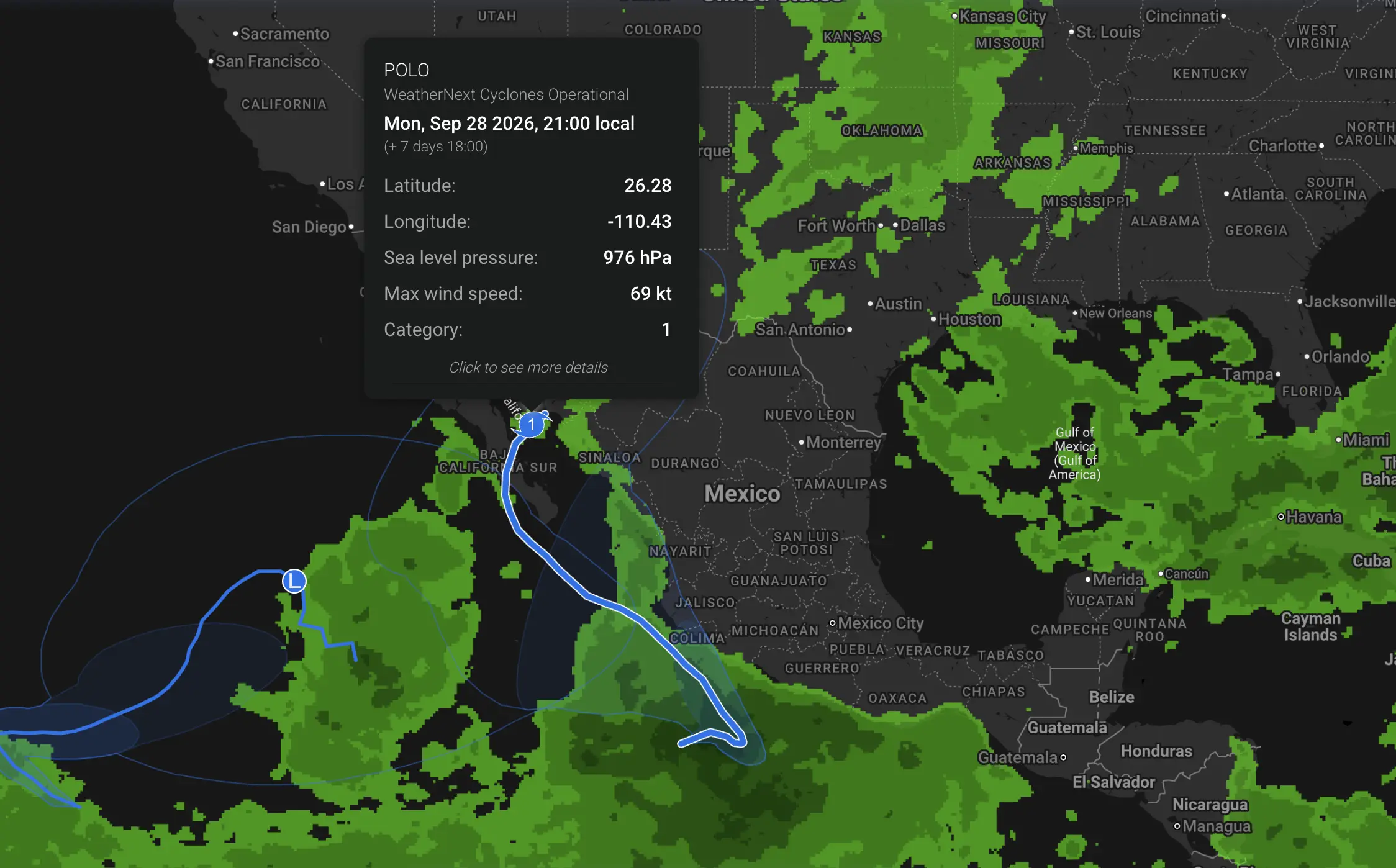
Hurricane Polo has undergone explosive intensification off southwestern Mexico and is now a powerful Category 4 hurricane. At 0600 UTC on Tuesday, September 22, the National Hurricane Center estimated maximum sustained winds of 130 mph, or 215 km/h, with a minimum central pressure of 955 hPa. Polo was centered near 14.7°N, 102.1°W, about 530 km south-southeast of Manzanillo and 340 km south of Zihuatanejo, moving east-southeast at about 7 km/h.
Only about a day earlier, Polo was still a tropical storm. Satellite analysis has shown a rapidly improving inner core and eye, with deep convection wrapping around the center. The official forecast now allows Polo to intensify further and reach Category 5 strength on Wednesday, September 23.
At a glance:
Current intensity: Category 4 hurricane with sustained winds near 215 km/h.
Central pressure: about 955 hPa in the latest intermediate advisory.
Category 5 risk: NHC forecasts a peak near 140 kt, about 260 km/h, on Wednesday, September 23.
Tropical Storm Watch: in effect from Tecpan de Galeana to Manzanillo.
Rainfall: 100–200 mm across coastal Guerrero and Michoacán, locally near 300 mm; 75–150 mm possible in coastal Oaxaca, Colima and Jalisco.
Main land threat: life-threatening flash flooding, mudslides, dangerous surf and rip currents even if the hurricane core remains offshore.
215 km/hcurrent sustained wind
~260 km/hforecast Category 5 peak
up to 300 mmisolated rainfall total
~9 mpeak seas already analyzed offshore
Hurricane Polo status on Tuesday, September 22
Parameter
Latest official value
Classification
Category 4 hurricane
Position
14.7°N, 102.1°W
Distance from Manzanillo
about 530 km south-southeast
Distance from Zihuatanejo
about 340 km south
Maximum sustained wind
215 km/h
Central pressure
955 hPa
Movement
east-southeast at about 7 km/h
Watch area
Tecpan de Galeana to Manzanillo
Category 5 hurricane is now possible
The latest NHC intensity forecast is more aggressive than the previous update. Polo is forecast to reach approximately 140 kt, or about 260 km/h, around Wednesday, September 23. That would place the cyclone in Category 5 on the Saffir-Simpson Hurricane Wind Scale.
The NHC discussion says conditions remain highly favorable for explosive intensification, with very warm ocean water, light vertical wind shear, abundant mid-level moisture and a compact inner core. The agency also notes that inner-core changes can cause intensity fluctuations after the peak.
Important: Polo is already a Category 4 hurricane. Category 5 is the official forecast for the next phase, not an observed intensity yet. The forecast can still change with every NHC advisory.
Tropical Storm Watch extended to Manzanillo
A Tropical Storm Watch is in effect from Tecpan de Galeana to Manzanillo. Tropical-storm-force conditions are possible somewhere in the watch area, generally within 48 hours.
The hurricane-force core is still forecast to remain mainly offshore, but the watch reflects the increasing risk from Polo’s outer circulation as it moves closer to southwestern Mexico and then turns northwest.
Official NHC forecast track: Tuesday, September 22 — Sunday, September 27
Time
Forecast position
Maximum sustained wind
Expected intensity
Tuesday, September 22 — 12 UTC
14.9°N 101.8°W
115 kt / 210 km/h
Category 4
Wednesday, September 23 — 00 UTC
15.1°N 101.7°W
140 kt / 260 km/h
Category 5
Wednesday, September 23 — 12 UTC
15.6°N 102.2°W
140 kt / 260 km/h
Category 5
Thursday, September 24 — 00 UTC
16.5°N 103.2°W
135 kt / 250 km/h
Category 4
Thursday, September 24 — 12 UTC
17.3°N 104.5°W
130 kt / 240 km/h
Category 4
Friday, September 25 — 00 UTC
17.7°N 106.0°W
125 kt / 230 km/h
Category 4
Saturday, September 26 — 00 UTC
18.6°N 109.2°W
115 kt / 215 km/h
Category 4
Sunday, September 27 — 00 UTC
20.1°N 111.7°W
105 kt / 195 km/h
Category 3
The track still keeps the hurricane center offshore through the forecast period. The most important uncertainty is the exact timing and location of the sharp northwest turn.
Will Hurricane Polo make landfall in Mexico?
A Mexican landfall is not currently forecast as a certainty. The official NHC center positions remain offshore, and the agency says it is still too early to determine the exact location or magnitude of coastal impacts.
However, the absence of a forecast landfall does not remove the risk. Polo’s rainbands, swells and tropical-storm-force winds can affect the coast well away from the eye. A relatively small track shift could also bring the strongest wind field closer to Guerrero, Michoacán or Colima.
Why Polo intensified so explosively
Polo is moving through an environment that strongly favors rapid intensification. Ocean temperatures south of Mexico are exceptionally warm, vertical wind shear is light, mid-level moisture is plentiful and the hurricane has developed a compact inner core.
The NHC discussion notes that satellite imagery shows an increasingly impressive structure, with a clearing eye and very cold cloud tops wrapping around the center. Those are classic signs of a rapidly strengthening tropical cyclone.
Intensity jump: tropical storm on Sunday night → hurricane on Monday → Category 4 by early Tuesday → possible Category 5 on Wednesday.
Mexico rainfall forecast: 100–200 mm, locally up to 300 mm
The greatest land threat may be rainfall rather than the hurricane-force wind core.
The NHC forecasts 4–8 inches, or roughly 100–200 mm, across coastal portions of Guerrero and Michoacán through Thursday, September 24, with isolated totals up to 12 inches, around 300 mm.
Coastal portions of Oaxaca, Colima and Jalisco may receive approximately 75–150 mm.
This rainfall can produce life-threatening flash flooding and mudslides, especially in mountainous terrain where tropical moisture is forced upslope and runoff concentrates rapidly in valleys, ravines and rivers.
City point forecasts are much lower than the regional flood forecast
Weather Forecaster point guidance shows why city-grid values must be interpreted carefully during a tropical cyclone. Narrow rainbands and terrain-enhanced precipitation can produce extreme totals only tens of kilometres away from a city point.
Location
Tuesday, September 22
Wednesday, September 23
Thursday, September 24
Friday, September 25
Peak gust signal
Zihuatanejo
0.8 mm
9.5 mm
3.3 mm
4.0 mm
around 51 km/h
Lázaro Cárdenas
3.3 mm
3.3 mm
20 mm
7.8 mm
around 59 km/h
Manzanillo
2.4 mm
near 0 mm
0.3 mm
2.7 mm
around 65 km/h
Model signal vs official warning: these are single-grid-point city forecasts. They do not override the NHC’s regional 100–300 mm rainfall guidance. During a tropical cyclone, official NHC, SMN/Conagua and local Protección Civil information takes priority.
Guerrero and Zihuatanejo: rainfall risk arrives before the closest approach
Guerrero is already exposed to Polo’s deep tropical moisture during the hurricane’s initial eastward phase. Heavy rain can occur even while the center remains well offshore.
The mountainous terrain north and east of the coast can rapidly amplify rainfall, increasing the risk of flash floods, landslides and road closures. Zihuatanejo and nearby communities should monitor updates closely even if city-grid rainfall remains much lower than the regional NHC totals.
Michoacán and Lázaro Cárdenas: one of the main flood-risk zones
Michoacán sits directly within the NHC’s highest storm-total rainfall zone. As Polo slows and turns northwest, moisture transport into the coastal mountains can become especially efficient.
The main concern is not simply the daily rainfall at one coastal point. It is the possibility of concentrated rainbands repeatedly affecting steep terrain and river basins inland.
Colima and Manzanillo: tropical storm conditions are now possible
Manzanillo is now included in the Tropical Storm Watch area. Although the current official track keeps Polo’s core offshore, a westward or northward shift would increase wind and rain impacts in Colima.
Swells and dangerous surf can arrive even without the eyewall approaching the city. Coastal conditions may therefore deteriorate well before any major rainfall reaches the immediate urban area.
Jalisco: risk increases as Polo turns northwest
Jalisco becomes more important later in the forecast as Polo turns northwest on Wednesday and Thursday. The official track moves the hurricane west-southwest of the Colima–Jalisco coast while it remains a major hurricane.
Coastal Jalisco is included in the NHC’s 75–150 mm rainfall zone, and dangerous surf and rip currents are expected along exposed beaches.
Dangerous surf and 9-metre seas
Polo is generating an extremely rough sea state. NHC high-seas analysis has already indicated seas near 9 metres close to the hurricane.
Swells generated by Polo are expected to affect southwestern Mexico. These swells can produce life-threatening surf and rip currents, including in places where rainfall remains limited.
Hurricane Polo timeline: September 22–27
Tuesday, September 22
Polo is already a Category 4 hurricane. Rapid intensification continues while the center moves east-southeast, with tropical-storm conditions possible near parts of southwestern Mexico.
Wednesday, September 23
The current NHC forecast reaches its peak near 140 kt, about 260 km/h — Category 5 intensity. Polo begins the sharp turn toward the northwest.
Thursday, September 24
Polo remains an extremely powerful Category 4 hurricane while moving northwest offshore. Heavy-rain, flooding, mudslide, surf and coastal-wind risks remain significant.
Friday, September 25
The center moves farther west of Colima and Jalisco but remains a major hurricane. Rainfall near the coast should gradually become more track-dependent.
Saturday, September 26
Polo is forecast to move farther into the Pacific and slowly weaken, but it may still remain a Category 4 hurricane.
Sunday, September 27
Gradual weakening continues farther offshore, with the current forecast still keeping Polo at major-hurricane intensity.
What could change in the next NHC advisory?
Three uncertainties remain especially important.
The exact point of the northwest turn. A turn farther east would bring the hurricane closer to Guerrero, Michoacán and Colima.
The intensity peak. Polo is in a rapidly changing inner-core phase, so eyewall cycles can cause short-term fluctuations even while the overall environment remains favorable.
The rainfall axis. The heaviest tropical rain does not have to fall under the eye. Terrain and rainband placement can shift local 200–300 mm maxima considerably.
Hurricane Polo: updated conclusion
Polo is no longer a tropical storm or a future Category 4 scenario. It is already a Category 4 hurricane.
At 0600 UTC on Tuesday, September 22, sustained winds were near 215 km/h and central pressure had fallen to 955 hPa.
The NHC now forecasts a possible Category 5 peak near 260 km/h on Wednesday, September 23. The core is still forecast to remain mainly offshore, so landfall in Mexico should not be presented as a certainty.
But the land threat has increased. A Tropical Storm Watch now extends to Manzanillo, up to 300 mm of rain is possible in the hardest-hit terrain, and dangerous surf and rip currents are expected along southwestern Mexico.
The next NHC advisories will be critical for determining exactly where Polo turns northwest, how close the eye comes to the coast and whether the hurricane reaches Category 5.
Follow local rain, wind and temperature forecasts across Mexico in Weather Forecaster. During a tropical cyclone, always use NHC, SMN/Conagua and local Protección Civil information as the primary sources for safety decisions.
Weather Forecaster forecast model: point forecasts for Manzanillo, Zihuatanejo and Lázaro Cárdenas.
This is a forecast update, not a guarantee of landfall. NHC advisories, Mexico’s SMN/Conagua and local Protección Civil information take priority over any single forecast scenario.
The Founder and Chief Meteorologist at Pogodnik.com. With over 15 years of operational experience in synoptic analysis and climate forecasting, he specializes in storm tracking, magnetic storms, and atmospheric dynamics. A recognized expert in Ukraine’s meteorological sector, he maintains strategic collaborations with global agencies, including NOAA and ECMWF, to ensure high-precision data integration. His analytical reviews and scientific contributions are regularly featured in leading media outlets dedicated to weather science and environmental trends.