Typhoon Jangmi Forecast: Japan, Okinawa and the Ryukyu Islands Brace for Heavy Rain, Dangerous Seas and Flood Risk
Typhoon Jangmi is the kind of storm that makes a chaser stop scrolling, zoom in on the track, and watch every model run. It is not just the wind core south of Japan that matters now. The bigger story is the wide moisture shield, dangerous seas, heavy rainfall bands and the spaghetti-model corridor pulling Jangmi toward the Ryukyu Islands and then close to the Pacific side of Japan through the first days of June 2026.
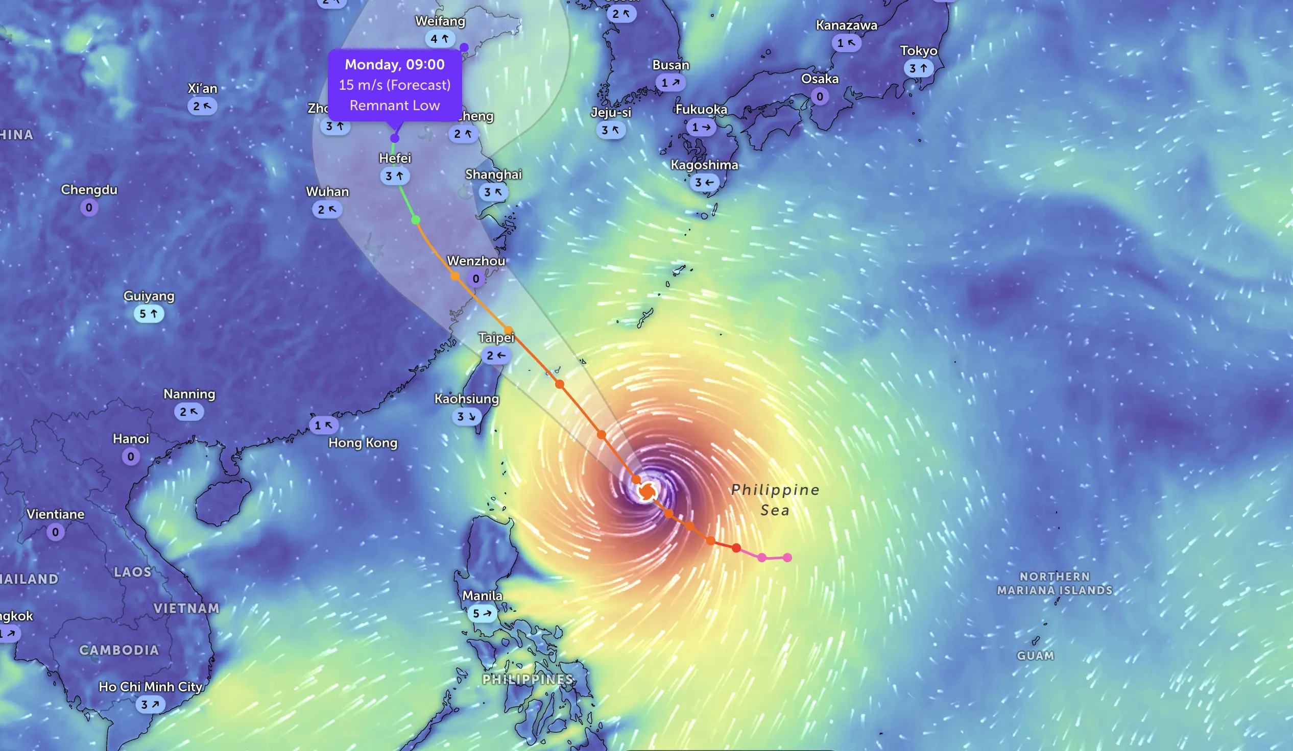
Jangmi intensified south of Japan and became a serious western Pacific threat for Okinawa, the Ryukyu Islands, waters east of Taiwan and parts of western and eastern Japan. The main danger is shifting from pure wind intensity to heavy rain, rough seas, storm surge exposure, landslides and river flooding. The spaghetti model screenshot shows a tight northeastward track corridor from the Philippine Sea past Japan, with the ensemble mean near eastern Honshu around June 3, 06:00 UTC, at about 982 hPa and 48 kt sustained winds. That is a weakening or transitioning storm signal, but still a dangerous rain and marine hazard.
Spaghetti model guidance for Typhoon Jangmi shows a strong northeastward clustering from the Philippine Sea toward Japan, with the ensemble mean near eastern Honshu around June 3, 2026.
Jangmi is not a storm to ignore
Jangmi has the look of a system that can punish areas far from the exact center. The track matters, yes — but with this kind of western Pacific typhoon, the rain shield, pressure gradient, feeder bands and ocean response can create major hazards even where the eye or remnant center stays offshore.
The Watchers reported that Jangmi strengthened south of Okinawa on May 31 and was forecast to bring heavy rainfall to Taiwan and southern Japan through June 3. The same report cited warnings for hazardous seas, strong winds, flooding and landslides, with nearly 300 flight cancellations in Japan from May 31 through June 2, mainly around Okinawa routes.
Jangmi is also known locally in the Philippines as Domeng. That matters because the storm has been interacting with the broader monsoon flow, helping enhance gusty winds and rough seas over parts of the northern Philippines, Batanes, Cagayan and nearby waters. Even after the strongest core moves away, the trailing moisture and monsoon surge can keep weather dangerous.
What the official data showed near peak intensity
According to the Watchers summary, the Joint Typhoon Warning Center reported Jangmi with maximum sustained winds of 130 km/h at 09:00 UTC on May 31, while the Japan Meteorological Agency analysis at 06:00 UTC placed the system moving north with a central pressure of 975 hPa, sustained winds near 108 km/h and gusts up to 162 km/h. JMA expected further intensification later on May 31, with pressure falling toward 970 hPa and gusts possibly reaching 180 km/h.
GDACS later classified JANGMI-26 as an overall green tropical cyclone event for Japan, based on maximum sustained wind, exposed population and vulnerability, but that does not mean the storm is harmless. GDACS still listed 1.3 million people exposed in Category 1 or higher wind conditions and a maximum wind speed of 139 km/h. Green impact categories can coexist with serious local flooding, transport disruption and coastal hazards.
Parameter
Reported or model signal
Why it matters
Storm name
Jangmi, also known as Domeng in the Philippines
Same cyclone, different regional naming systems.
Region at greatest concern
Okinawa, Ryukyu Islands, waters east of Taiwan, western/eastern Japan
These areas face the combined risk of rain, wind, waves and coastal hazards.
Reported JMA pressure on May 31
About 975 hPa at 06:00 UTC
A deep tropical cyclone with a strong pressure gradient and dangerous marine conditions.
Reported JTWC wind signal
Up to 130 km/h sustained winds at 09:00 UTC on May 31
Enough for damaging wind potential near the core and exposed islands.
Wave hazard near core
Significant waves around 12.2 m reported by JTWC via Watchers
Very dangerous for shipping, fishing boats, ferries and coastal operations.
Spaghetti screenshot mean near June 3
Near 35.80°N, 140.89°E, 982 hPa, 48 kt sustained winds
Suggests a weakening but still potent system near eastern Honshu and the Kanto offshore zone.
The spaghetti model: a tight track, but not a zero-risk track
The spaghetti map is the most important visual clue here. The ensemble tracks are not spraying wildly in every direction. They are clustered into a northeastward corridor, starting south of Japan, passing close to the Ryukyu chain and then bending toward the Pacific side of Japan. That kind of model clustering gives forecasters more confidence in the general track, but it does not remove the local uncertainty.
The ensemble mean on the screenshot places Jangmi near 35.80°N and 140.89°E around Wednesday, June 3, 2026, at 06:00 UTC. That is close to the Kanto-side zone of eastern Honshu, with Tokyo, Chiba and nearby Pacific-facing districts needing to watch the rain bands and coastal waters closely. The model mean shows sea-level pressure around 982 hPa and sustained winds around 48 kt, below typhoon strength but still strong enough to create rough seas and hazardous coastal weather.
The chaser read is simple: do not focus only on the black center dot. Watch the right-front quadrant, the offshore rain bands, the pressure gradient and the moisture feed into terrain. In Japan, heavy rain hitting mountains and river basins can become the bigger story than the exact landfall point.
Heavy rainfall, high waves, dangerous marine conditions, landslide risk in steep terrain.
June 2–3
Western and eastern Japan, Pacific side of Honshu
Heavy rain, flooding, landslides, rough surf, possible transport and aviation impacts.
Around June 3, 06:00 UTC
Near eastern Honshu/Kanto offshore corridor based on the spaghetti mean
Weaker wind core but still a serious rain, wave and coastal hazard.
Okinawa and the Ryukyu Islands: first line of impact
Okinawa and the Ryukyu chain are the first major watch zone. These islands can take a storm’s marine energy hard, even when the center passes nearby rather than directly overhead. Strong gusts, ferry disruption, airport delays, coastal spray, high surf and short-fuse flooding can all occur in a storm like Jangmi.
The Watchers report noted that more than 290 flights were canceled from May 31 through June 2, mainly departures from and arrivals in Okinawa. That is a serious signal for travelers: if your route depends on Okinawa, Naha, Amami or nearby island airports, check airline updates repeatedly and do not assume a single morning forecast will hold all day.
Taiwan and the northern Philippines: rain bands and monsoon surge
For Taiwan, the main concern is not necessarily a direct hit from the center. The more realistic hazard is the outer circulation, moisture transport and bands that can enhance rainfall, especially over eastern and northern terrain. When tropical moisture runs into mountains, rainfall can intensify quickly and create localized flooding or landslides.
For the northern Philippines, the cyclone’s local name Domeng is important because it has interacted with the southwest monsoon. The Watchers report noted strong to gale-force gusts in Batanes, Cagayan and many parts of Luzon and the Visayas, with rough seas along the eastern coast of Batanes. Small craft, ferry operators and coastal communities should treat this as a dangerous marine setup even if the typhoon center is moving away.
Japan: the rain threat may outlast the wind headline
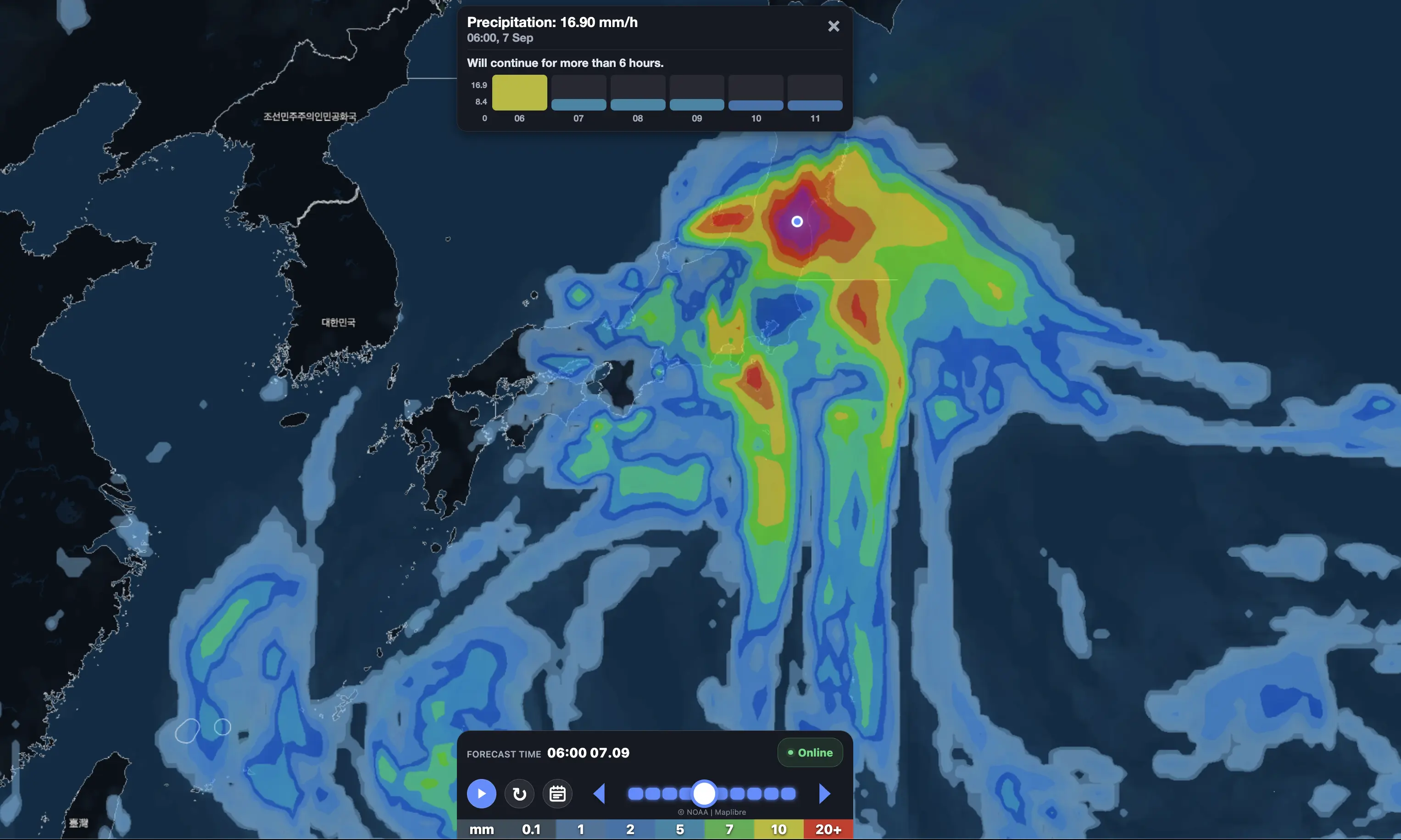
Japan’s biggest issue may become rainfall rather than the storm’s official category. NHK, cited by Watchers, reported that JMA warned of heavy rain exceeding 200 to 300 mm in various areas, with people urged to take precautions against strong winds, high waves, storm surges, landslides, overflowing rivers and flooding in low-lying areas.
The Guardian also reported that Jangmi was expected to bring strong winds and heavy rain to parts of Japan early in the week, with risks of flooding, storm surge and landslides. It noted that JMA expected pressure to fall to about 965 hPa, with maximum winds increasing and gusts potentially reaching 110 mph on Monday.
For residents and travelers in Japan: the safest forecast mindset is to plan for flooding first, not just wind. Avoid riverbanks, coastal roads, underpasses, mountain roads and low-lying parking areas during peak rain. Landslides can occur after the heaviest rain has already passed.
What would make this storm worse?
There are several ways Jangmi can overperform local expectations even if the center stays offshore or begins weakening. First, if the storm accelerates northeast while interacting with the mid-latitude flow, rain bands can become elongated and intense along the Pacific side of Japan. Second, if the right-front side of the storm lines up with coastal terrain, wind-driven rain and wave action can increase quickly. Third, saturated soils can turn later rainfall into faster runoff.
Risk factor
Why it matters
Who should watch closely
Track shifts west
Brings stronger wind and rain closer to populated areas of Japan.
If you are in Japan, Taiwan, the Ryukyu Islands or traveling through East Asia, keep official alerts open and use Pogodnik as an additional planning tool for day-by-day and hour-by-hour weather awareness.
FAQ: Typhoon Jangmi forecast
Where is Typhoon Jangmi heading?
The main forecast corridor takes Jangmi from the Philippine Sea toward the Ryukyu Islands and then northeast toward the Pacific side of Japan. The spaghetti screenshot shows a clustered track near eastern Honshu around June 3.
Will Jangmi make landfall in Japan?
The spaghetti guidance suggests the center may track close to the Pacific side of Japan, but the exact landfall or offshore path can still shift. Even without a direct landfall, heavy rain, rough seas and landslides remain serious hazards.
What is the biggest danger from Jangmi?
The biggest danger is likely heavy rainfall combined with landslides, flooding, high waves and transport disruption. Wind remains a concern near the core and exposed islands, but rainfall may become the larger impact as Jangmi moves toward Japan.
Which areas should monitor the storm most closely?
Okinawa, the Ryukyu Islands, Amami, waters east of Taiwan, parts of the northern Philippines, Kyushu, Shikoku, the Kii Peninsula, Tokai and Kanto should monitor official forecasts closely.
What does the spaghetti model show?
The spaghetti model shows many ensemble tracks bending northeast near Japan, with the ensemble mean near 35.80°N and 140.89°E around June 3, 06:00 UTC. That places the system close enough to eastern Honshu to keep rain, surf and coastal hazards in focus.
Is Jangmi still dangerous if it weakens?
Yes. A weakening tropical cyclone can still produce dangerous rainfall, flooding, rough seas and landslides, especially when moisture interacts with mountainous terrain and populated coastal zones.
Sources and methodology
This forecast is based on the Watchers report on Typhoon Jangmi, GDACS/JTWC impact information, Guardian weather tracker reporting and the user-provided spaghetti model screenshot. The spaghetti-model analysis is treated as guidance, not a deterministic forecast. For life-safety decisions, always follow Japan Meteorological Agency, local government and emergency-management instructions.
The Founder and Chief Meteorologist at Pogodnik.com. With over 15 years of operational experience in synoptic analysis and climate forecasting, he specializes in storm tracking, magnetic storms, and atmospheric dynamics. A recognized expert in Ukraine’s meteorological sector, he maintains strategic collaborations with global agencies, including NOAA and ECMWF, to ensure high-precision data integration. His analytical reviews and scientific contributions are regularly featured in leading media outlets dedicated to weather science and environmental trends.