Hurricane Nolo threatens Hawaii as Gonzalo forms near Cabo Verde: six tropical systems active across the Pacific and Atlantic
The global tropics are unusually busy as multiple hurricanes and tropical storms move simultaneously across the Pacific and Atlantic. The main threat is Hurricane Nolo south of Hawaii, where forecasters warn of potentially catastrophic flooding on the Big Island, while newly formed Tropical Storm Gonzalo has triggered a Tropical Storm Warning for all of Cabo Verde.
At a glance:
Nolo: hurricane south of Hawaii, with catastrophic rainfall risk and a sharp westward turn expected near the Big Island.
Gonzalo: newly formed tropical storm near Cabo Verde, where a Tropical Storm Warning is in effect.
Polo: still a very powerful eastern Pacific hurricane, now moving away from southwestern Mexico.
Odalys: strong Category 2 hurricane over open water with no direct land warning.
Fay: central Atlantic tropical storm expected to weaken and become post-tropical.
Surigae: strengthening western Pacific system approaching the waters south of Okinawa.
890 mmisolated Big Island rainfall potential from Nolo
120 km/hNolo sustained winds in the latest cited advisory
75 km/hGonzalo sustained winds near Cabo Verde
240 km/hPolo sustained winds in the latest cited advisory
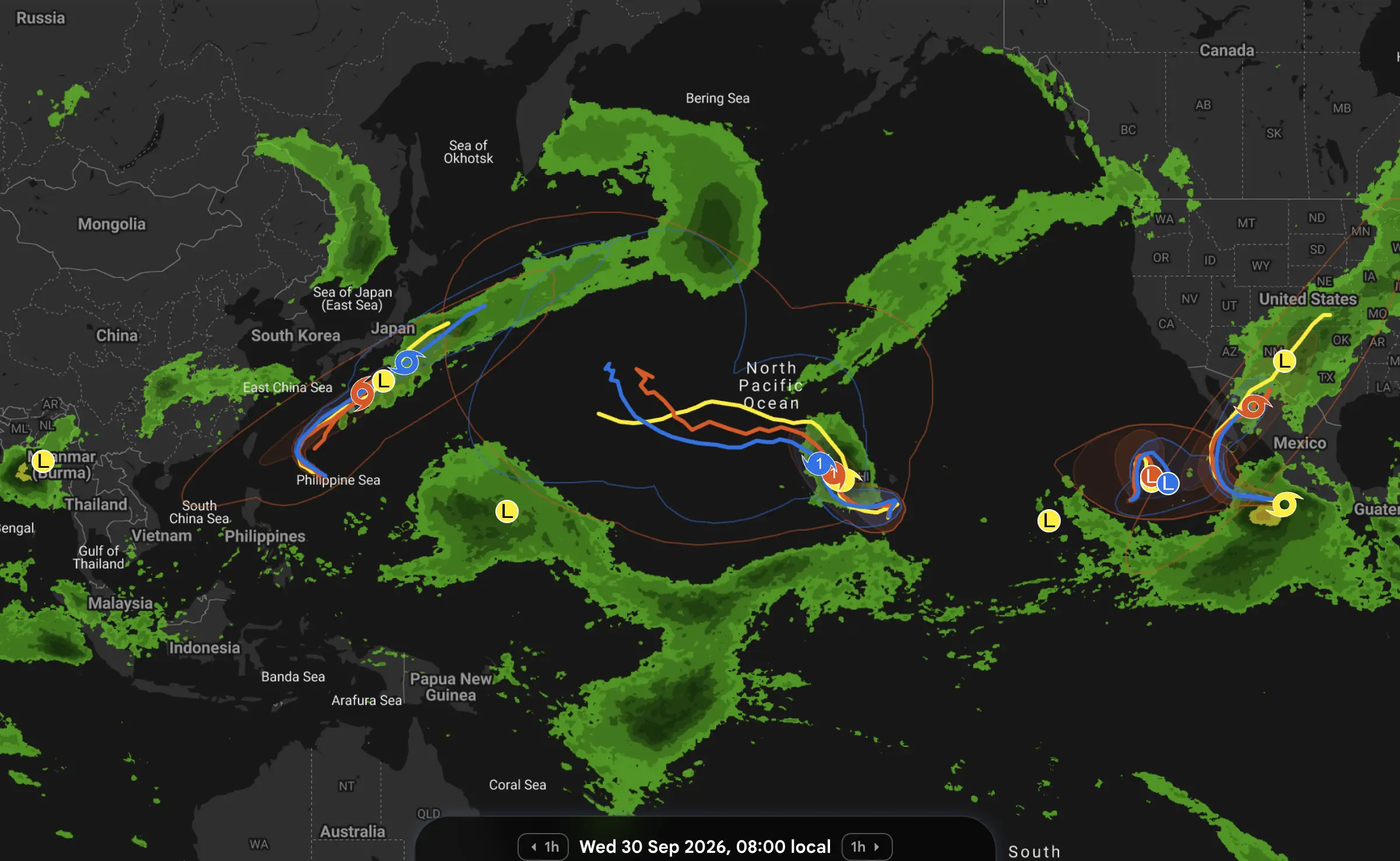
The Pacific-wide forecast map also shows how complex the pattern has become: one tropical cyclone is developing east of the Philippines and curving toward Okinawa, Nolo is approaching Hawaii from the south, two hurricanes remain active in the eastern Pacific, and a broad rain corridor stretches from Mexico into the southwestern United States.
Important: colored tracks on broad forecast maps should be treated as forecast scenarios rather than official tracks. For storm intensity, warnings and evacuation decisions, official NHC/CPHC and JMA advisories take priority.
Nolo is now a hurricane — and Hawaii is the main area of concern
The biggest change is Nolo.
Air Force Hurricane Hunter reconnaissance confirmed Thursday evening that Nolo had strengthened into a hurricane.
At 8:00 PM HST on Thursday, September 24, the center was near 15.3°N, 155.8°W, approximately 410 km south of South Point, Hawaii, with maximum sustained winds of 120 km/h, minimum pressure of 984 hPa, and movement toward the north-northeast at around 7 km/h.
A faster north-northeastward motion is expected through Friday, September 25.
Then comes the critical part of the forecast.
NHC expects a sharp turn toward the west on Saturday, September 26, just south of the Big Island. At the same time, Nolo is forecast to continue strengthening and could become a major hurricane.
That forecast turn is also the most important uncertainty visible on the map. A difference of even 50–100 km in the turning point could dramatically change the distribution of hurricane-force wind, rain and coastal flooding across the Big Island.
Hawaii warnings
A Tropical Storm Warning and Hurricane Watch are in effect for Hawaii County.
A Tropical Storm Watch is in effect for Maui County.
Tropical-storm-force winds could begin on the Big Island by late Friday, September 25, while hurricane conditions are possible by early Saturday, September 26.
Nolo rainfall could become catastrophic
NHC’s rainfall forecast is exceptionally high.
For the eastern and southern Big Island, Nolo is expected to produce 15–30 inches, roughly 380–760 mm, with isolated maxima around 35 inches — nearly 890 mm.
For western Big Island, the official forecast calls for about 125–200 mm, locally 250 mm.
Maui could receive approximately 100–200 mm, with isolated totals near 380 mm.
NHC explicitly warns that this could produce catastrophic and life-threatening flash flooding and mudslides, especially on steep terrain.
The risk is especially serious on the windward slopes of the Big Island. Tropical air is forced upward over the island’s mountains, dramatically increasing rainfall on the eastern and southeastern sides.
Weather Forecaster model guidance confirms a strong east-west rainfall contrast
Supplemental local model guidance supports that orographic contrast.
Location
Friday, September 25
Saturday, September 26
Sunday, September 27
Hilo
37 mm
77 mm
49 mm
Kona
6 mm
2 mm
4 mm
This difference does not contradict NHC. City-grid forecasts represent single model points, while NHC’s rainfall forecast covers broader terrain and explicitly accounts for narrow, extreme orographic rainfall bands.
For hazards, NHC’s 380–890 mm official rainfall outlook has higher priority than any individual city-grid total.
Why Nolo could intensify rapidly
Nolo’s structure improved rapidly during Thursday. Air Force reconnaissance found a falling central pressure and a strengthening inner core, while satellite imagery began showing a developing banding-type eye.
The storm is moving through a favorable tropical environment with sufficiently warm ocean water and a period of relatively supportive upper-level winds.
That is why the official forecast allows for steady to rapid intensification.
The key question is not only how strong Nolo becomes, but where exactly it makes its westward turn relative to the Big Island. That will determine whether Hawaii primarily faces an extreme rainfall disaster, or a combination of extreme rain plus damaging hurricane winds.
What the Nolo tracks on the map mean
The current official NHC/CPHC scenario has Nolo moving north-northeast first and then turning sharply west just south of Hawaii.
Some track solutions bend farther north; others remain farther south. The wider track envelope around Hawaii is exactly why residents should focus on the forecast cone and official warnings, not one single model line.
Nolo’s center can remain offshore and still produce catastrophic rainfall.
Search interest in “Hurricane Nolo” is rising
The Google Trends signal flagged for “hurricane nolo” is consistent with the sudden escalation in official alerts after Nolo became a hurricane.
That search interest makes sense meteorologically: this is no longer simply a distant tropical storm. Hawaii County is under a Tropical Storm Warning and Hurricane Watch, and NHC is using unusually strong wording about possible catastrophic flooding.
Gonzalo forms near Cabo Verde — Tropical Storm Warning issued
A second important development is taking place in the far eastern tropical Atlantic.
Tropical Storm Gonzalo formed south-southeast of Cabo Verde early Friday, September 25.
At 5:00 AM Cabo Verde time, Gonzalo was approximately 260 km east-southeast of the southernmost Cabo Verde Islands, moving north-northwest at about 13 km/h.
Maximum sustained winds were approximately 75 km/h, and central pressure was 1004 hPa.
A Tropical Storm Warning is in effect for all Cabo Verde Islands.
Cabo Verde rainfall
NHC expects around 30–75 mm across eastern portions of Cabo Verde on Friday, September 25, and Saturday, September 26. Western islands should generally receive less than 25 mm.
Parts of Guinea-Bissau, The Gambia and Senegal could receive 50–100 mm, locally more along the immediate coast.
Supplemental Weather Forecaster model guidance for Praia gives about 15 mm on Friday, September 25, with forecast gusts reaching approximately 58 km/h.
Again, this is a point forecast. Local rainbands near Gonzalo could produce much larger totals than the city-grid value.
Gonzalo may strengthen briefly, then weaken
NHC says some strengthening is possible during Friday. However, increasing upper-level wind shear is expected to become less favorable over the weekend, so a gradual weakening trend is forecast.
This means Gonzalo is very different from Nolo. Nolo is entering an intensification phase; Gonzalo appears to have a relatively short window for strengthening before atmospheric conditions become more hostile.
Its immediate issue is therefore Cabo Verde wind, rain and dangerous surf, rather than a long-lived major hurricane scenario.
Hurricane Polo remains extremely powerful west of Mexico
The major cyclone visible off Mexico on the map is Hurricane Polo.
Polo briefly reached Category 5 strength earlier this week and remains an exceptionally powerful hurricane.
At the cited 0300 UTC advisory on Friday, September 25, Polo was a Category 4 hurricane with maximum sustained winds of 240 km/h, minimum pressure of 935 hPa, located approximately 315 km southwest of Manzanillo.
It was moving west at about 19 km/h.
NHC says Polo could regain Category 5 status before weakening begins later Friday or Saturday.
The important change for Mexico is that the core is now moving away from the southwestern coast. Coastal tropical storm warnings have been discontinued, although Baja California Sur is being advised to continue monitoring the hurricane.
Hurricane Odalys is turning in the open eastern Pacific
Farther west of Mexico, another hurricane remains active: Odalys.
At 0300 UTC on Friday, September 25, Odalys had strengthened to maximum sustained winds of approximately 175 km/h, making it a strong Category 2 hurricane.
The center was roughly 1,625 km west-southwest of the southern tip of Baja California, moving east-northeast at around 13 km/h.
The forecast calls for a gradual turn toward the northeast on Friday and then toward the north during the weekend.
Unlike Nolo and Gonzalo, Odalys currently poses no direct land hazard, and no coastal warnings are in effect.
Tropical Storm Fay remains isolated over the central Atlantic
Another active storm, not visible on the Pacific-centered map, is Tropical Storm Fay.
Fay is located approximately 1,675 km west-southwest of the Azores, with maximum sustained winds near 85 km/h, pressure around 1005 hPa, and movement west at only about 9 km/h.
There are no coastal watches or warnings.
Fay could strengthen slightly for a short time, but stronger wind shear and dry air are expected to weaken the system. NHC expects Fay to become post-tropical during the weekend and then dissipate.
Western Pacific: Surigae developing east of the Philippines
The western side of the map shows another major tropical corridor stretching from the Philippine Sea toward Japan.
The active system there is Typhoon No. 26, Surigae.
As of 9:00 JST on Friday, September 25, Surigae was east of the Philippines, moving west-northwest at about 20 km/h, with central pressure near 1000 hPa, maximum sustained winds near 20 m/s — 72 km/h, and gusts around 30 m/s — 108 km/h.
The cyclone is forecast to intensify and gradually turn north.
By Sunday, September 27, it is expected to reach the waters south of Okinawa as a stronger typhoon.
After that, the system may slow. That creates a potentially important situation for Okinawa and the Amami Islands, because slower motion can extend the duration of strong winds, waves and heavy rain.
Farther ahead, the track toward mainland Japan remains uncertain.
Japan: the broad rain shield is not one single cyclone
A large precipitation band extends east and northeast of Japan into the North Pacific.
That should not automatically be interpreted as a single typhoon rain shield.
Part of this precipitation is associated with frontal and extratropical systems over the North Pacific, while Surigae is the tropical system developing farther south near the Philippines and Okinawa.
This distinction matters because Japan can experience widespread rain from an autumn front at the same time that a tropical cyclone approaches from the south.
South China Sea, Philippines and Southeast Asia: broad low pressure remains active
The map also shows broad low-pressure circulation and large rain areas around the Philippines, South China Sea, Vietnam, Myanmar and Thailand.
These are important monsoon and low-pressure zones, but the official sources checked for this update do not identify every “L” symbol on the map as a named tropical cyclone.
Therefore they should be described as areas of disturbed weather or low pressure, not automatically as tropical storms.
Southwest United States and northern Mexico: not a tropical hurricane track
On the eastern side of the map, a long precipitation corridor extends from Mexico into the southwestern and central United States.
A low-pressure center is also visible inland. This feature should not be confused with Polo.
Polo is offshore in the eastern Pacific. The inland system is part of a broader continental low/frontal moisture pattern, while Polo’s tropical circulation remains west of Mexico.
Global tropical cyclone snapshot
System
Basin
Current status
Main movement / forecast
Main concern
Nolo
Central Pacific
Hurricane, 120 km/h
NNE, then sharp west turn south of Hawaii
Catastrophic rain risk, Big Island wind/surge
Gonzalo
Atlantic
Tropical Storm, 75 km/h
NNW across Cabo Verde region
Tropical Storm Warning, rain and surf
Polo
East Pacific
Category 4, 240 km/h
West, then WNW/NW
Moving away from SW Mexico; could regain Cat 5
Odalys
East Pacific
Category 2, 175 km/h
ENE → NE → N
Open ocean, no land warning
Fay
Atlantic
Tropical Storm, 85 km/h
Slow westward
No land threat; weakening expected
Surigae
Western Pacific
Typhoon
WNW then north toward Okinawa
Strengthening; Okinawa/Amami risk
What the map says about the next five days
The image is especially useful as a large-scale pattern map.
It shows the entire Pacific basin operating almost like a conveyor belt of tropical and subtropical systems.
In the western Pacific, Surigae is forecast to curve north toward Okinawa. Across the central Pacific, Nolo becomes the most important land-impact system because its track bends close to Hawaii.
Farther east, Polo is moving away from Mexico while Odalys follows a curved open-ocean path.
Meanwhile, large non-tropical and monsoon rain areas remain active from Southeast Asia to the continental United States.
Outside this Pacific frame, the Atlantic now has Gonzalo near Cabo Verde and Fay over the central ocean.
Nolo is the storm to watch most closely
Among all active systems, Nolo currently deserves the highest attention for direct human impact.
It is strengthening. Its track makes a sharp turn near populated islands. Official hurricane and tropical storm alerts are active. And NHC is forecasting rainfall amounts that could approach 890 mm in parts of the Big Island.
Supplemental Weather Forecaster model guidance also supports a multi-day heavy-rain episode in eastern Hawaii, though its city-grid totals are lower than the official terrain-enhanced NHC forecast.
The key period is Friday, September 25 through the weekend.
A relatively small track change could determine whether the Big Island mainly experiences catastrophic flooding or a much more dangerous combination of flooding and hurricane-force winds.
Track tropical weather in Weather Forecaster
Follow local rain, wind and temperature forecasts across Hawaii, Cabo Verde, Mexico and Japan. During tropical cyclones, always use NHC/CPHC, JMA and local emergency information as the primary source for safety decisions.
NHC / Central Pacific Hurricane Center: official advisories for Hurricane Nolo, Hurricane Polo, Hurricane Odalys, Tropical Storm Gonzalo and Tropical Storm Fay.
Western Pacific: JMA-derived current information for Typhoon No. 26 Surigae and its forecast toward Okinawa.
Weather Forecaster forecast model: point guidance for Hilo and Kona on Hawaii Island and Praia, Cabo Verde; used only as supplemental local forecast guidance, not as the official tropical cyclone warning source.
Forecast tracks and intensity can change quickly. Official tropical-cyclone advisories and local emergency information take priority over individual model scenarios.
The Founder and Chief Meteorologist at Pogodnik.com. With over 15 years of operational experience in synoptic analysis and climate forecasting, he specializes in storm tracking, magnetic storms, and atmospheric dynamics. A recognized expert in Ukraine’s meteorological sector, he maintains strategic collaborations with global agencies, including NOAA and ECMWF, to ensure high-precision data integration. His analytical reviews and scientific contributions are regularly featured in leading media outlets dedicated to weather science and environmental trends.