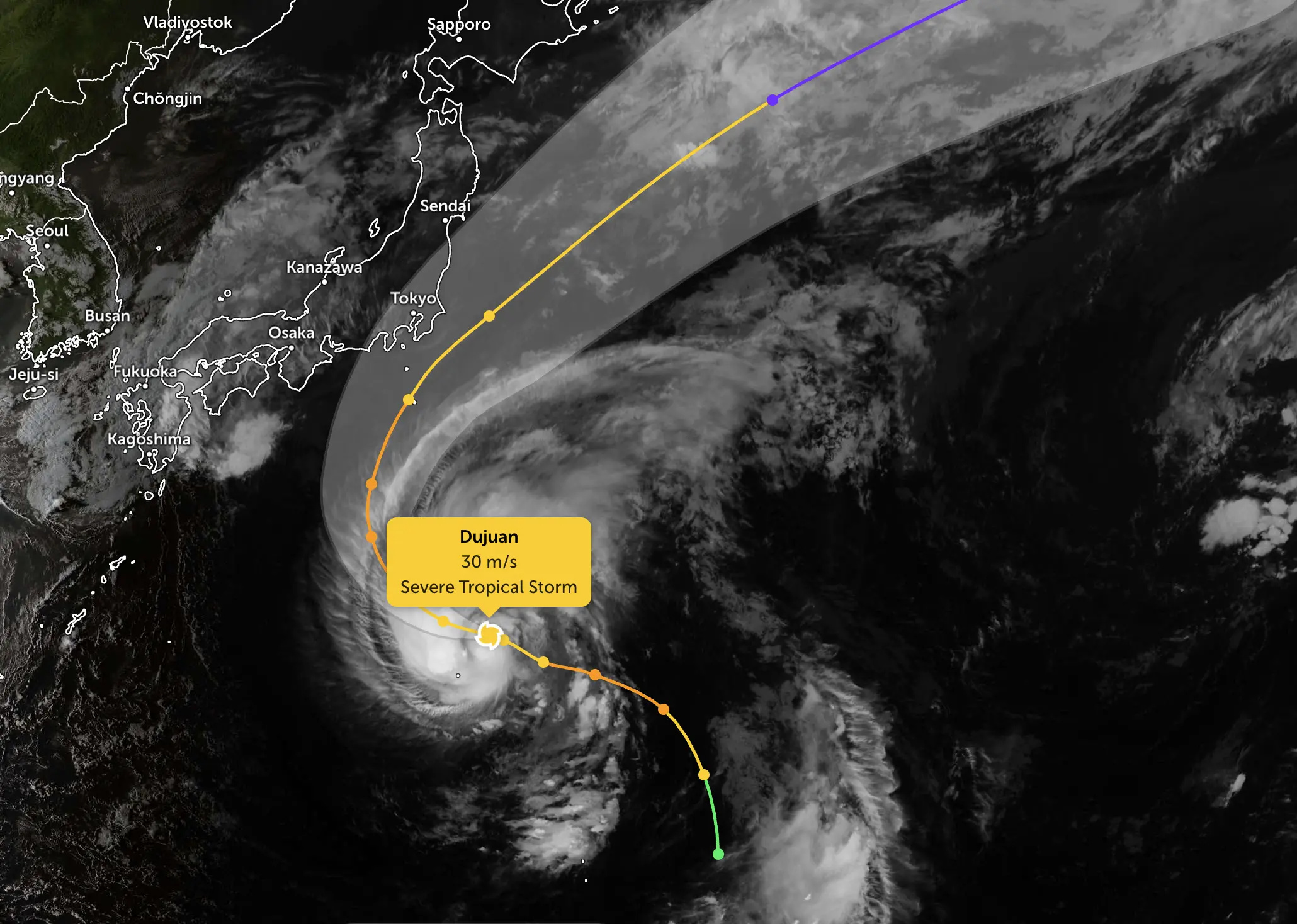
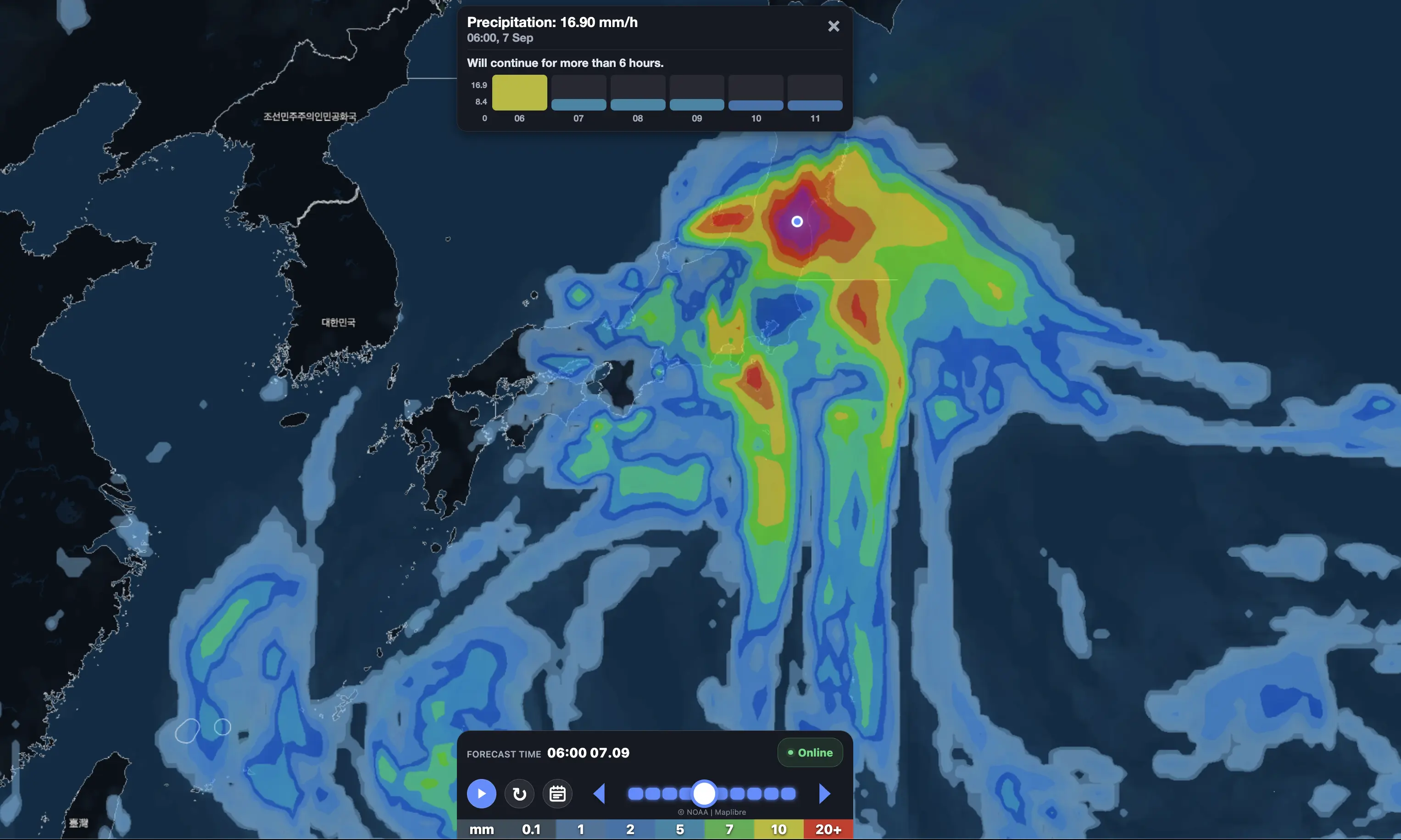
Typhoon Dujuan is now passing the Izu Islands and closing in on the Kanto region as an already dangerous rain disaster expands across eastern Japan. JMA’s latest 14:00 JST estimate places the large, strong typhoon about 40 km northwest of Hachijojima, with central pressure near 960 hPa, sustained winds of 40 m/s (144 km/h) and gusts to 55 m/s (198 km/h). The cyclone is moving northeast at about 25 km/h.
Rainfall impacts are already severe. Reuters reports that parts of the Izu Islands and Chiba Prefecture have received more than 300 mm of rain since Saturday, with flood and landslide warnings in force. In Yokohama, the emergency situation has escalated further: official municipal and Kanagawa disaster portals confirm Level 4 evacuation orders in selected districts. Level 4 means people in dangerous areas should evacuate. The storm center does not need to cross central Tokyo or Yokohama for the rain and landslide threat to become life-threatening.
At a glance — September 21 emergency update:
Dujuan: 960 hPa, sustained wind 40 m/s, gusts 55 m/s, moving northeast near 25 km/h.
Current position: about 40 km northwest of Hachijojima at 14:00 JST.
Izu / Chiba: some locations have already exceeded 300 mm of accumulated rain since Saturday.
Yokohama: Level 4 evacuation orders are active in selected areas of several wards.
Tokyo/Kanto: the heaviest rain is expected through the afternoon and evening, with flooding and landslide risk rising rapidly.
Open-Meteo signal: full-day September 21 point forecasts are around 250–275 mm for Tokyo/Yokohama and about 219 mm for Chiba, with intense hourly bursts.
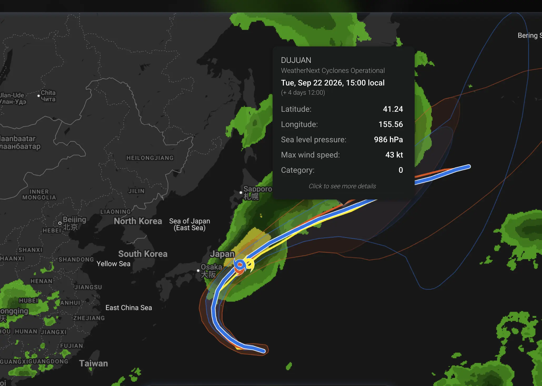
Track: Dujuan is forecast to accelerate northeast tonight, pass east of Kanto, move offshore of Sanriku on September 22 and become extratropical east of Japan by September 23.
960 hPacurrent central pressure
55 m/smaximum gusts — about 198 km/h
Level 4evacuation orders active in parts of Yokohama
Dujuan has strengthened into a large, strong typhoon near Hachijojima
The storm is now significantly stronger than it was in the previous article update. The latest JMA-derived 14:00 estimate gives a central pressure of 960 hPa, maximum sustained winds of 40 m/s and maximum gusts of 55 m/s.
The center was estimated roughly 40 km northwest of Hachijojima, moving northeast at about 25 km/h. This is slightly different from some earlier media snapshots that placed the center around 50 km northwest and moving near 30 km/h; the newer JMA-derived estimate is used here.
Dujuan remains classified by JMA as a large and strong typhoon. Its large wind field means dangerous conditions extend far from the center.
Official forecast rule: the center track is not the impact map. Kanto can experience dangerous rain, flooding and landslides even if Dujuan’s center remains offshore.
Yokohama confirms Level 4 evacuation orders
This is the most important new public-safety development in the Kanto region.
Yokohama’s disaster portal is operating in emergency mode, and the Kanagawa Prefecture disaster portal confirms Level 4 evacuation orders in selected areas of Tsurumi, Hodogaya, Kohoku, Totsuka and Tsuzuki wards, alongside Level 3 evacuation information in several other wards.
Under Japan’s warning system, Level 4 means everyone in dangerous locations should evacuate. Residents should follow the exact municipal instructions for their address rather than assuming the order covers an entire ward.
Examples of current Level 4 evacuation areas
In Tsurumi Ward, Level 4 orders were issued for parts of Kami-sueyoshi 5-chome and Komaoka 3-chome.
In Hodogaya Ward, the city confirms an evacuation order for part of Sakuragaoka 1-chome after a landslide occurred. The affected area includes two households and six residents.
In Totsuka Ward, Level 4 orders expanded by early afternoon to include parts of Yoshida-cho, Yabe-cho, Minami-Maioka, Matano-cho and Maeda-cho, among other landslide-warning zones. The official portal lists large numbers of households in some of these areas — for example, more than 1,100 households in part of Yabe-cho and nearly 800 in part of Yoshida-cho.
Do not generalize the order to all of Yokohama. Level 4 orders apply to specified hazard areas. Residents should use Yokohama City or Kanagawa Prefecture disaster portals to check their exact address and nearest open evacuation site.
Why Yokohama is now at serious risk even before the typhoon’s closest approach
The danger is not coming only from the wind core.
Dujuan is pulling an enormous tropical moisture plume northward into the frontal zone over Kanto. This is producing long-duration rain before the center makes its closest approach. Once the typhoon moves farther north this afternoon and evening, stronger wind and additional rain bands will overlap with ground that is already saturated.
That is a classic setup for landslides, urban flooding and rapid runoff. Hillside neighborhoods are particularly vulnerable because saturated soils can fail even if rainfall intensity temporarily decreases.
The official Level 4 evacuation orders are therefore a response to actual local hazard conditions, not merely a precaution based on a computer model.
More than 300 mm already recorded in Izu and Chiba
Reuters reports that some locations in the Izu Islands and Chiba Prefecture have already accumulated more than 300 mm of rainfall since Saturday. Flood and landslide warnings have been issued as Dujuan approaches eastern Japan.
This accumulated rainfall is critical. A second or third burst of intense rain can cause a much larger disaster than the same rainfall amount over dry ground because soils, drains and rivers are already under stress.
Authorities are also watching for linear rain bands — narrow, persistent corridors of thunderstorms capable of producing extreme rainfall over the same locations for several hours.
Open-Meteo update: Tokyo, Yokohama and Chiba remain in the main rain corridor
The fresh Open-Meteo point forecast strongly supports the official concern, although these values are model guidance, not observations.
Location
September 21 forecast rainfall
Peak hourly forecast
Peak forecast gust
Yokohama
about 274 mm
about 40 mm/h
about 74 km/h
Tokyo
about 251 mm
about 41 mm/h
about 62 km/h
Chiba
about 219 mm
about 28 mm/h
about 84 km/h
Shizuoka
about 62 mm
about 9 mm/h
about 71 km/h
Nagoya
about 5 mm
light rain
about 44 km/h
The latest forecast therefore reinforces a major shift already visible in the article’s previous update: the highest impact corridor is now Kanto — especially Tokyo, Yokohama and Chiba — rather than Nagoya.
Open-Meteo’s daily totals should not be compared directly with Reuters’ “300+ mm” accumulated observations. The Reuters figure covers rainfall since Saturday in some locations, while the table above is a point forecast for the September 21 calendar day.
Yokohama: rain could intensify sharply through the afternoon and evening
The latest hourly forecast for Yokohama is particularly concerning.
Rainfall increases through the afternoon, with several forecast hours in the 20–40 mm/h range. Wind gusts also strengthen, reaching roughly 60–75 km/h during the evening.
Atmospheric pressure falls rapidly toward the upper 980s hPa before recovering later tonight as the typhoon pulls northeast. That combination — falling pressure, strengthening wind, saturated terrain and repeated tropical rainbands — explains why evacuation orders can escalate quickly even before the storm center reaches its closest point to Kanto.
Tokyo: dangerous rain remains possible without a direct center crossing
Tokyo’s current point forecast is similar to Yokohama’s, with more than 250 mm for the day and a peak hourly signal around 40 mm.
Wind in central Tokyo is less extreme than the forecast around exposed Chiba or offshore areas, but gusts can still exceed 60 km/h.
The key risk in Tokyo is therefore not simply “how close does the eye pass?” The combination of prolonged rain, drainage overload and rivers responding to upstream rainfall may be more important for many neighborhoods.
Chiba: already saturated, with the strongest wind signal among the major cities checked
Chiba has already experienced extreme rainfall in parts of the prefecture, and the new Open-Meteo forecast still gives about 219 mm for September 21.
Forecast gusts rise above 80 km/h late in the day. Combined with saturated ground, this increases the risk of fallen trees, localized power disruption and additional landslides.
Reuters reports that rainfall totals above 300 mm have already been observed in parts of Chiba since Saturday.
Shizuoka: heavy weather continues, but the main axis has shifted east
Shizuoka remains in a wet and windy environment, but the updated point forecast is much lower than the earlier 100+ mm model scenarios.
The latest Open-Meteo forecast gives around 62 mm for September 21, with gusts around 70 km/h. This is still significant, especially in mountainous terrain, but the strongest current rainfall signal is farther east across Kanto.
Nagoya: much lower direct weather impact, but regional disruption continues
Nagoya remains well west of the main rain corridor. The latest point forecast gives only about 5 mm of rain for September 21 and gusts near 40–45 km/h.
That does not mean the region is unaffected. Reuters reports that the Asian Games’ equestrian competition in Aichi was postponed because of the typhoon. Transport and event disruption can extend far beyond the area of highest rainfall.
Dujuan’s next path: Kanto tonight, then rapidly out to sea
JMA’s forecast keeps Dujuan strong while it accelerates northeast.
Time
Forecast position
Intensity / movement
September 21, 14:00 JST
about 40 km northwest of Hachijojima
960 hPa; 40 m/s; gusts 55 m/s; northeast ~25 km/h
September 21, 21:00 JST
about 100 km east-southeast of Katsuura
strong typhoon; around 960 hPa; northeast ~35 km/h
September 22, 00:00 JST
about 150 km east of Choshi
strong typhoon; accelerating northeast around 45 km/h
September 22, 12:00 JST
offshore of Sanriku
strong typhoon; east-northeast around 50 km/h
September 23, 09:00 JST
far east of Japan
forecast to become an extratropical cyclone
The forecast track keeps the center mostly offshore of mainland Kanto, but the broad wind field and tropical rain shield overlap heavily with the Tokyo metropolitan region.
Could Dujuan still make landfall in Kanto?
A direct mainland Kanto landfall is not the main official center-track scenario in the latest guidance. The center is forecast to pass offshore and accelerate northeast.
However, this distinction has become less important for immediate public safety because severe impacts are already occurring inland. Heavy rain, landslides and evacuation orders can occur without the eye crossing the coast.
What Level 4 means for residents
Yokohama’s official guidance defines Level 4 as an evacuation order: people in dangerous places should evacuate.
Residents should not wait for a higher Level 5 alert. Level 5 indicates that a disaster may already be occurring or imminent, and it may not always be issued.
If outdoor evacuation has become more dangerous because of extreme rain or wind, residents should follow local emergency instructions on vertical evacuation or moving to a safer part of a sturdy building.
Track local Japan weather in Weather ForecasterFollow rain, wind and hourly conditions for Tokyo, Yokohama, Chiba, Shizuoka and Nagoya. During a typhoon, official JMA and municipal evacuation instructions always take priority over weather-app model guidance.
Japan Meteorological Agency: official typhoon track and warning system. JMA typhoon information.
Yokohama City Disaster Prevention Portal: current evacuation information and Level 4 evacuation guidance. Yokohama disaster portal.
Kanagawa Prefecture Disaster Information Portal: current Level 4 evacuation orders by ward and neighborhood. Kanagawa disaster portal.
Reuters: observed rainfall above 300 mm in parts of the Izu Islands and Chiba, plus flood and landslide warnings.
Open-Meteo Forecast API: updated point forecasts for Yokohama, Tokyo, Chiba, Shizuoka and Nagoya. These are model forecasts and are not official warnings.
This is an emergency forecast update. Official JMA warnings, municipal evacuation orders and local emergency instructions take priority over individual model runs or app forecasts.
The Founder and Chief Meteorologist at Pogodnik.com. With over 15 years of operational experience in synoptic analysis and climate forecasting, he specializes in storm tracking, magnetic storms, and atmospheric dynamics. A recognized expert in Ukraine’s meteorological sector, he maintains strategic collaborations with global agencies, including NOAA and ECMWF, to ensure high-precision data integration. His analytical reviews and scientific contributions are regularly featured in leading media outlets dedicated to weather science and environmental trends.