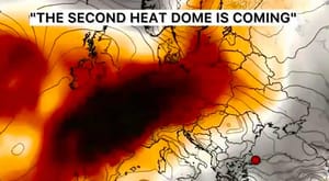
Europe’s Heat Returns After the Cold Blast: Where the Late-September Warm Surge Will Hit — and Where It May Fall Short
Europe is about to swing from one extreme to another. Just days after a sharp polar intrusion brought the first snow to the Romanian and Ukrainian Carpathians, frost risk to parts of Germany and unusually cold conditions across the Balkans, a large ridge of high pressure is building back across western and southern Europe.
The change will be dramatic in some regions.
Southern Spain is forecast to approach 37–38°C, southwestern France will climb above 30°C, northern Italy will warm again toward the upper 20s, and parts of the Balkans will recover by more than 10 degrees from this week’s cold spell.
But there is an important update.
Fresh Weather Forecaster model guidance checked on Tuesday, September 22, shows that the warming is not equally strong everywhere, and some of the more aggressive heat-dome scenarios published earlier are not yet confirmed at city level.
Spain and southwestern France clearly support a major late-season heat signal. Germany warms later. Italy and the Balkans recover substantially. But Paris, London and Stockholm are currently much cooler than the broadest heat-dome projections would suggest.
At a glance:
Southern Spain: the strongest confirmed heat signal, with Seville near 37–38°C.
Southwestern France: Bordeaux around 31–32°C, consistent with official Météo-France guidance for the Garonne corridor.
Italy: warming builds later, especially Sunday, September 27, through Tuesday, September 29.
Germany: immediate heat is not confirmed; stronger warming is delayed toward Tuesday, September 29, and Wednesday, September 30.
London, Paris and Stockholm: mild to warm, but no short-range major heatwave signal in the latest city guidance.
Europe is flipping from a polar outbreak to a heat dome
The large-scale atmospheric pattern over Europe is undergoing a major reversal.
Earlier this week, cold air plunged southward through Eastern Europe and the Balkans. Snow reached the high Carpathians in Romania and Ukraine, including Bâlea Lac and Mount Pip Ivan, while temperatures fell sharply from Germany through Romania, Bulgaria and the western Balkans.
Now the pressure pattern over the Atlantic and Europe is reorganizing.
A deep upper-level trough is developing over the North Atlantic while a strong ridge expands northward from North Africa and the Mediterranean into western and central Europe.
That creates a powerful southerly to southwesterly flow between the Atlantic low and the continental ridge.
In simple terms, Europe begins drawing much warmer air northward from Spain, North Africa and the western Mediterranean.
Severe Weather Europe describes the pattern as a renewed heat dome, with unusually warm air at roughly 850 hPa — around 1.5 km above sea level — spreading across large portions of the continent and anomalies potentially reaching 8–12°C above average in parts of western, central and eventually northern Europe.
The physical mechanism is straightforward.
Under a strong ridge, air slowly sinks. As that air descends, it is compressed and warms. Cloud formation is suppressed, sunshine becomes more persistent and the ground heats efficiently during the afternoon.
That is why strong blocking highs can turn an already warm air mass into exceptional surface heat.
Where the heat arrives first: Spain and Portugal
The clearest and most robust heat signal is over the Iberian Peninsula.
Severe Weather Europe projects temperatures of 34–38°C across south-central Spain and Portugal, with some scenarios approaching 40°C locally before the weekend.
Fresh Weather Forecaster city guidance strongly supports the broad heat signal, though not necessarily 40°C in every city.
No meaningful rainfall is forecast through the entire period.
AEMET independently confirms the same trend: its current forecast for Seville reaches 37°C Wednesday and Thursday and around 38°C Friday, with dry conditions.
This is therefore one of the strongest confirmed late-September heat signals in Europe.
Why southern Spain gets so hot
very warm continental air is already present over Iberia;
the building ridge suppresses clouds and precipitation;
the southwesterly circulation limits the arrival of cooler Atlantic air across inland Andalusia.
The result is several consecutive days in the mid-to-upper 30s. For late September, that is exceptionally hot.
Lisbon: hot at first, then Atlantic influence returns
Portugal experiences a somewhat different evolution.
Weather Forecaster model guidance gives Lisbon around 31–32°C from Tuesday, September 22, through Friday, September 25, around 27°C on Saturday, September 26, and approximately 24–25°C on Sunday, September 27, and Monday, September 28.
So the heat dome does reach western Iberia, but the Atlantic begins moderating coastal Portugal earlier than inland southern Spain.
This illustrates one of the most important features of this setup: the Atlantic trough and continental heat ridge sit side by side.
A small shift in their boundary can mean the difference between 24°C and 35°C.
France: strong heat in the southwest, much weaker in Paris
France will also warm substantially, but the strength of the heat depends heavily on location.
Météo-France officially says temperatures will remain above seasonal averages through the end of September, with values often exceeding 30°C in southern France. It expects approximately 32–33°C along the Garonne corridor around Wednesday, September 23, and Thursday, September 24.
Bordeaux: clear heat-dome signal
Tuesday, September 22: 28.9°C
Wednesday, September 23: 30.7°C
Thursday, September 24: 32.2°C
Friday, September 25: 30.1°C
After that, cooler Atlantic air begins pushing inland and temperatures fall. This is a strong late-season hot spell.
Paris: warmer, but not a 30°C heatwave in the latest run
The broad Severe Weather Europe scenario had suggested northern France and the Benelux could climb into the low 30s.
Current Weather Forecaster city guidance does not support that for Paris this week.
Date
Forecast high
Tuesday, September 22
24.2°C
Wednesday, September 23
25.2°C
Thursday, September 24
22.0°C
Friday, September 25
25.2°C
Saturday, September 26
23.2°C
Sunday, September 27
21.6°C
Monday, September 28
24.2°C
Tuesday, September 29
26.0°C
Paris is warm for the time of year, but the present city forecast does not show a 30°C event.
This does not mean the upper-level ridge forecast is wrong. It means the hottest low-level air currently remains farther southwest, while northern France stays closer to the boundary of the Atlantic flow.
United Kingdom: warmth reaches southern England, but no major heatwave
The broader heat-dome analysis suggests a brief spell of mid-to-upper 20s for southern England. Current Weather Forecaster guidance is more conservative.
For London, Tuesday, September 22, reaches about 24.4°C; Wednesday falls near 21.7°C; Thursday near 19.8°C; Friday rebounds to 23.7°C; the weekend stays around 20–21°C; and Monday, September 28, falls to around 16.6°C.
So London gets mild to warm weather, but the latest city forecast does not confirm a sustained late-September heatwave.
The Atlantic trough remains too close. Farther west — especially Ireland and western Scotland — the influence of the Atlantic remains stronger.
Severe Weather Europe also highlights a high-moisture corridor into the western British Isles, with heavy orographic rainfall possible in exposed western areas.
Germany: the warming is delayed
Germany is perhaps the clearest example of why timing matters.
The broad heat-dome analysis suggests temperatures could rise toward 27–29°C, especially from Sunday into early next week. But the current city forecast shows that this warming arrives later than the core Iberian heat.
The current forecast does support the idea of a warm ridge expanding into Germany — but later, around the very end of September rather than immediately this weekend.
DWD’s short-range forecast also remains cool for Wednesday, September 23, and Thursday, September 24, with many German stations around 16–20°C.
For Germany the best wording is: warming is likely, but the strongest phase is delayed toward Tuesday, September 29, and Wednesday, September 30.
Milan is therefore not seeing immediate 30°C heat, but the upward trend is clear.
Florence and Tuscany
Tuesday, September 22: 27.2°C
Wednesday, September 23: 25.5°C
Thursday, September 24: 25.7°C
Friday, September 25: 23.1°C
Saturday, September 26: 26.0°C
Sunday, September 27:28.3°C
Monday, September 28:29.3°C
This closely matches the broader analysis, which identifies Tuscany and the Po Valley as among the warmest areas of Italy once the ridge strengthens.
Italy’s warming is real, but it is strongest toward Sunday, September 27, through Tuesday, September 29, not uniformly throughout the week.
Balkans: a dramatic rebound after the cold blast
The Balkans have just experienced one of the sharpest cool spells of the month. Temperatures fell dramatically, and snow reached high terrain in Romania and Bulgaria. Now the pattern reverses.
Zagreb
Tuesday, September 22: 18.6°C
Wednesday, September 23: 19.7°C
Thursday, September 24: 21.1°C
Friday, September 25: 17.4°C
Saturday, September 26: 20.5°C
Sunday, September 27: 23.3°C
Monday, September 28:24.7°C
That is a significant rebound from the cool middle of the week.
Greece returns toward late-summer warmth by the weekend. This is consistent with the larger ridge gradually expanding east and northeast.
Scandinavia: the strongest warmth is not here yet
The broader scenario projects the warm ridge farther north toward Sweden and Finland around the turn of the month, suggesting that the strongest temperature anomalies could eventually shift into Scandinavia.
Current Weather Forecaster city guidance for Stockholm does not yet show major warmth through Monday, September 28.
Tuesday, September 22: 17.0°C
Wednesday, September 23: 16.8°C
Thursday, September 24: 15.0°C
Friday, September 25: 13.6°C
Saturday, September 26: 13.6°C
Sunday, September 27: 14.2°C
Monday, September 28: 15.2°C
Tuesday, September 29: 17.0°C
Wednesday, September 30: 17.4°C
Thursday, October 1: 17.6°C
So the northward expansion of the warm anomaly remains a longer-range signal, not yet a strong short-range surface heat event in Stockholm.
Upper-air temperature anomalies can become very strong before the full surface response appears at a specific city. Clouds, wind direction, proximity to cold seas and shallow autumn boundary layers can all limit daytime temperatures.
Main cities: Tuesday, September 22 — Monday, September 28
Phase 1 — Iberia and southwestern France: Tuesday, September 22 — Friday, September 25
This is the strongest immediate heat zone. Southern Spain reaches 36–38°C. Southwestern France reaches 30–33°C. Portugal remains hot, though Atlantic moderation begins near the coast.
Phase 2 — Italy and the central Mediterranean: Saturday, September 26 — Tuesday, September 29
The ridge expands east. Northern and central Italy warm into the upper 20s. Florence approaches 29–30°C. Milan reaches the upper 20s. Parts of the Balkans rebound into the low-to-mid 20s after the cold spell.
Phase 3 — Germany and farther north: around Tuesday, September 29, into early October
Fresh Weather Forecaster guidance suggests the warm push into Germany is delayed. Berlin goes from only 14°C on Friday, September 25, to about 26°C by Wednesday, September 30 — a rise of roughly 12°C in five days.
This supports the broader atmospheric idea of the ridge migrating northeast, although the exact intensity remains lower in some cities than earlier deterministic scenarios suggested.
Why this warm spell is so unusual
Late September is a transition season. Solar radiation is already much weaker than in July or August, nights are significantly longer and the average temperature declines rapidly across northern and central Europe.
That means reaching 35–38°C in Spain or near 30°C in Tuscany this late in the month requires a particularly warm air mass plus strong subsidence and sunshine.
Severe Weather Europe estimates that parts of western Europe could experience near-surface temperature anomalies around 10–14°C above late-September climatology in the core of the warm spell.
But that number should be treated as a regional anomaly signal, not a promise that every city will be 10–14°C above average.
The Atlantic low is just as important as the heat dome
A heat dome does not develop in isolation.
The deep trough over the North Atlantic actually helps amplify the ridge over continental Europe. The stronger the Atlantic trough becomes, the stronger the southwesterly flow on its eastern side can become.
That flow transports warm air northward from Iberia, North Africa and the Mediterranean.
This creates an atmospheric dipole: Atlantic low to the west + strong European ridge to the east.
Between them lies a fast southwesterly corridor. That same corridor can carry very moist air toward Ireland, western Scotland and Norway.
So Europe can simultaneously have 37°C sunshine in Spain and heavy Atlantic rainfall farther northwest.
Why the heat dome does not mean heat everywhere
A “heat dome over Europe” is a continental-scale description. It does not mean London, Paris, Berlin, Stockholm, Madrid and Milan all experience the same temperature.
distance from the ridge center;
wind direction near the surface;
cloud cover;
proximity to the Atlantic or North Sea;
elevation;
soil moisture;
timing of frontal passages;
how deeply the warm upper-level air mixes down to the surface.
That is why Seville can reach 37°C while Berlin remains near 14–19°C on the same day.
Spain: the strongest confirmed heat risk
Of all the claims in the broader European heat-dome scenario, Spain has the strongest short-range confirmation.
Weather Forecaster model guidance gives Seville 36–37°C for several consecutive days. AEMET gives very similar values and predicts up to 38°C.
AEMET’s seasonal outlook also favors above-normal temperatures across Spain during September–October–November, though seasonal guidance should not be interpreted as a day-to-day heatwave forecast.
So the late-September Spanish heat is supported at multiple time scales.
France: official forecasts confirm the southern heat
Météo-France provides strong official support for the southern French warming.
Its September 21 update says the air mass is warming and temperatures will remain above seasonal averages through the end of September.
It expects widespread temperatures above 30°C in the south, and 32–33°C around the Garonne basin.
Météo-France also highlights a significant wildfire danger because hot, dry weather is combining with already dry vegetation around the Mediterranean.
Germany: why the forecast is less certain
The difference between Severe Weather Europe’s broad 27–29°C German scenario and the cooler short-range city forecast is mostly a question of timing.
DWD still has Germany near the upper teens around Wednesday, September 23, and Thursday, September 24. The city forecast then begins warming Berlin after Monday, September 28, reaching about 26°C by Wednesday, September 30.
So the warming mechanism exists. What remains uncertain is exactly how quickly the ridge expands eastward and how efficiently the warmer air reaches the surface.
What happens at the end of September?
The biggest forecast question is whether the ridge continues migrating north and east.
Severe Weather Europe argues that ensemble trends favor blocking through the end of September and into early October, with the warm anomaly eventually extending from France and Germany toward Denmark, Sweden and Finland.
Fresh Weather Forecaster guidance provides partial support for that evolution. Berlin clearly warms by Wednesday, September 30. Paris reaches 26°C on Tuesday, September 29, though it then turns cooler again. Stockholm warms only modestly toward 17–18°C.
So the broad warm ridge remains plausible, but the surface heat signal becomes much less certain with latitude and forecast lead time.
Is this another summer heatwave?
In southern Spain, the answer is effectively yes in terms of temperature. Values near 37–38°C would qualify as genuine summer-like extreme heat even though astronomical autumn has begun.
In southwestern France, 30–33°C is also exceptionally warm for late September.
In northern France, Britain, Germany and Scandinavia, however, it is more accurate to describe the event as an unseasonably warm spell rather than a confirmed heatwave based on current short-range forecasts.
Could records fall?
Potentially, especially in southwestern Europe.
But record claims require comparison with official station climatology.
A 37–38°C forecast for Seville is extremely hot for late September, but it should not automatically be called a record until AEMET confirms the relevant station record.
Similarly, 30–33°C in southern France is highly unusual, but whether a local record falls depends on the station and exact date.
For now, the safest description is: exceptional late-season heat with potential for local records, especially in Spain and southern France.
What about wildfire danger?
This may become one of the more important secondary impacts.
Météo-France specifically notes that persistent warmth and lack of rain are increasing wildfire sensitivity in southern France, where vegetation remains very dry.
Southern Spain is also forecast to remain completely dry during the hottest phase.
Several consecutive days near 35–38°C, low humidity and dry fuels can increase fire-weather risk even without strong winds.
Any official wildfire restrictions or alerts should be checked locally.
What the latest forecasts confirm — and what they do not
Strongly confirmed
Southern Spain: mid-to-upper 30s, locally near 38°C.
Southwestern France: 30–33°C.
Northern/central Italy: warming into the upper 20s late in the week.
Balkans: substantial recovery after the polar outbreak.
Germany: warming arrives later, particularly around Tuesday, September 29, and Wednesday, September 30.
Partially confirmed
Paris / northern France: warm, but the latest city guidance stays mostly in the low-to-mid 20s rather than 30°C.
London: mild to warm, but no major heatwave signal.
Stockholm / Scandinavia: warmer air may arrive later, but strong surface warmth is not yet confirmed through the end of September.
Not confirmed in the latest city forecast
widespread 30°C temperatures across northern France;
27–29°C in Berlin during the immediate weekend;
a major warm spell in Stockholm before Tuesday, September 29.
Those outcomes could still reappear in later runs if the ridge strengthens or shifts.
Europe weather forecast: Tuesday, September 22 — Monday, September 28
Region
Peak timing
Current signal
Spain
Thursday, September 24 — Saturday, September 26
Seville around 36–37°C, locally possibly hotter
Portugal
Tuesday, September 22 — Friday, September 25
Lisbon near 31–32°C, followed by Atlantic cooling
Southwestern France
Wednesday, September 23 — Friday, September 25
Bordeaux around 31–32°C
Paris / northern France
Variable
Mainly 22–26°C, warmer than average but much less extreme
United Kingdom
Tuesday and Friday
Southern England mostly 20–24°C
Germany
Later, around Sep. 29–30
Berlin cool first at 14–19°C, then much warmer
Northern Italy
Sunday, September 27 — Monday, September 28
Milan gradually rises toward 27°C
Tuscany
Sunday, September 27 — Monday, September 28
Florence approaches 29°C
Balkans
Weekend
Temperatures recover into the low-to-mid 20s
Greece
Sunday, September 27 — Monday, September 28
Athens rises back toward 27°C
Scandinavia
Later-range signal
Stockholm still mostly 14–17°C
The bigger picture: Europe’s weather pendulum swings again
The most remarkable feature of late September 2026 may not be the absolute heat alone. It is the speed of the transition.
Within days, the continent moves from snow in the Carpathians, frost risk in Germany and unusually cold Balkan weather to 37°C in southern Spain, 32°C in southwestern France and a rapidly rebuilding warm ridge over central Europe.
That dramatic swing is the result of highly amplified atmospheric circulation.
A deep Atlantic trough and a strong European ridge are creating large north-south exchanges of air.
One week sends polar air deep into southeastern Europe. The next draws subtropical air far north.
Conclusion
A major warm pattern is returning to Europe, but the latest data show it will be highly uneven.
The strongest and most certain heat is over Spain and southwestern France, where temperatures of 30–38°C are strongly supported by both city guidance and national forecasts.
Italy and the Balkans warm more gradually. Germany likely sees its most important warming closer to the end of September.
Farther north, especially around Stockholm, the aggressive early-October heat-dome scenario remains a longer-range possibility rather than a fully confirmed short-range event.
The key feature to watch is the position of the Atlantic trough.
If it stays farther west, the European ridge can expand farther north and east, allowing much warmer air into Germany and Scandinavia. If the Atlantic low shifts east sooner, western and northern Europe will cool before the heat dome fully develops.
Track Europe weather in Weather Forecaster
Follow hourly temperature, precipitation and wind changes as the ridge expands across Europe and the Atlantic boundary shifts from day to day.
Severe Weather Europe — synoptic analysis of the late-September/early-October ridge, Atlantic trough, heat-dome development and projected temperature anomalies: analysis.
Météo-France — official guidance confirming renewed heat across southern France, 30°C+ temperatures, 32–33°C potential along the Garonne corridor and elevated wildfire danger: official update.
AEMET — official Seville forecast confirming approximately 36–38°C during the peak of the late-September hot spell: Seville forecast.
DWD — official German short-range guidance confirming the immediate Wednesday, September 23 — Thursday, September 24 period remains much cooler before later warming.
Weather Forecaster forecast model — city-level temperature and precipitation checks for Seville, Lisbon, Bordeaux, Paris, London, Berlin, Milan, Florence, Zagreb, Athens and Stockholm, with extended checks through Thursday, October 1, for Paris, Berlin and Stockholm.
This is a weather forecast, not a guarantee of record temperatures. Official warnings and local emergency information from national meteorological services take priority over model guidance.
The Founder and Chief Meteorologist at Pogodnik.com. With over 15 years of operational experience in synoptic analysis and climate forecasting, he specializes in storm tracking, magnetic storms, and atmospheric dynamics. A recognized expert in Ukraine’s meteorological sector, he maintains strategic collaborations with global agencies, including NOAA and ECMWF, to ensure high-precision data integration. His analytical reviews and scientific contributions are regularly featured in leading media outlets dedicated to weather science and environmental trends.