Winter 2026–2027 Forecast: Historic El Niño, Snowfall Outlook and Polar Vortex Risk
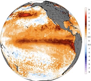
The Winter 2026–2027 forecast has received its strongest update yet. El Niño is now firmly established, the World Meteorological Organization expects it to strengthen into a very strong event, NOAA says there is a 69% chance of a historically strong October–December peak, and NOAA GFDL’s newest experimental forecast keeps all 30 ensemble members in historically strong territory.
Winter 2026–2027 at a glance
- A very strong, potentially historic El Niño is the dominant seasonal driver, with persistence through winter highly likely.
- The southern United States has the strongest wet/storm-track signal, while Canada and much of the northern U.S. lean warmer overall.
- Snow potential is strongest in selected western mountains and parts of the Central Plains, Ohio Valley and Mid-Atlantic, especially later in winter.
- Much of lowland Europe leans toward below-normal snowfall, while northern Europe and the higher Alps retain a better snow signal.
- A possible weakening of the Polar Vortex around late December and January remains the key mid-winter wildcard; a specific SSW cannot be forecast this far ahead.
Local winter forecasts: Los Angeles · Denver · New York City · London · Kyiv
This matters because the newest ECMWF and UKMO snowfall forecasts are now showing the first clear winter snow map:
more snow potential across the Sierra Nevada, Utah, the Central and Southern Rockies, the Central Plains and parts of the eastern United States; less reliable seasonal snow across the Pacific Northwest, northern U.S. and much of southern Canada; and a widespread lowland snow deficit across Europe, except for northern areas and the higher Alps.
Winter 2026–2027 in one sentence:
A very strong, potentially historic El Niño is now the dominant winter driver, favoring a wet southern U.S. storm track, warmer Canada and northern U.S., a stronger mid-to-late winter snow signal across parts of the West, Plains and Mid-Atlantic, and a mild Atlantic-driven Europe where elevation and latitude will decide who gets snow.
Updated September 9, 2026 using WMO, NOAA/CPC, NOAA GFDL SPEAR, ECMWF and UKMO snowfall guidance summarized by Severe Weather Europe, and a fresh September ECMWF SEAS5 ensemble-mean run.

What changed in the Winter 2026–2027 forecast?
The biggest uncertainty from early summer is gone. We are no longer asking whether El Niño will form strongly enough to influence winter.
El Niño is firmly established and already coupled to the atmosphere.
~100%
WMO likelihood El Niño persists through February 2027
>90%
NOAA chance of a very strong event during fall/winter
69%
NOAA chance OND reaches a historic RONI threshold
30 / 30
GFDL ensemble members keep a historically strong El Niño
The September 2026 El Niño upgrade:
- WMO: El Niño is firmly established, should strengthen further, and is expected to become very strong before peaking toward the end of 2026.
- WMO persistence: near-100% likelihood that El Niño continues through February 2027.
- NOAA/CPC: greater than 90% chance of a very strong El Niño during Northern Hemisphere fall and winter.
- Historic scenario: CPC gives a 69% chance that the October–December RONI reaches at least +2.5°C, exceeding previous events in the record dating to 1950 by that metric.
- GFDL SPEAR: the September forecast trimmed the peak slightly from August, but all 30 members still show an El Niño capable of competing with or surpassing the strongest historical events.
One detail needs careful wording: NOAA’s current seasonal ENSO probability table gives a 100% probability of
El Niño conditions
through DJF. That is not the same as saying there is a 100% chance of record strength. The record-strength estimate remains a separate 69% October–December scenario.
Severe El Niño winter weather outlook: why the search interest is justified
The phrase
severe El Niño winter weather outlook
is now describing a real atmospheric setup, not a speculative summer forecast.
Very strong El Niño events typically strengthen the subtropical jet across the southern United States and displace the main storm track southward. The result is a classic north-south winter split:
- warmer seasonal background across Canada and much of the northern U.S.;
- more Pacific moisture across California and the southern U.S.;
- more opportunities for southern and central U.S. winter storms when cold air is available;
- reduced seasonal snow in parts of the Pacific Northwest, northern Plains and Great Lakes;
- a milder Atlantic flow into much of Europe.
A strong El Niño does not guarantee a snowstorm in any city. It changes the background odds and the preferred storm tracks.
New snowfall forecast: the strongest signal in the latest update
The September 3 Severe Weather Europe snowfall update adds something much more concrete than a general warm/wet winter map: it shows the first month-by-month ECMWF and UKMO snowfall anomalies for Winter 2026–2027.
United States and Canada: where snowfall now looks better
The ECMWF seasonal-average snow forecast shows above-normal snowfall potential across parts of the
Southwest, Central Plains, Midwest, eastern U.S. and Mid-Atlantic
, while the highest western mountain potential is focused on the
Sierra Nevada, Utah, Great Basin and Central/Southern Rockies
.
The season starts slowly in December, then the signal strengthens sharply in January and February.
| Period | Stronger snow signal | Weaker snow signal |
|---|---|---|
| December | Central Plains; parts of East/Northeast; some western high elevations | Pacific Northwest, Great Lakes, much of northern U.S., southern Canada |
| January | Sierra Nevada, Great Basin, Central Rockies, Central/Southern Plains, Midwest, Ohio Valley, Mid-Atlantic | Pacific Northwest, northern Plains, much of western Canada |
| February | Broad southern-half U.S. corridor from Sierra/Central Rockies through Plains, Ohio Valley and Mid-Atlantic | Pacific Northwest, northern Plains, Great Lakes, New England, much of southern Canada |
UKMO independently shows a similar January expansion of above-average snowfall across the western, central and eastern United States. That agreement is important because it reduces the chance that the pattern is just one model’s isolated signal.
Europe: less snow overall, but not everywhere
The new ECMWF and UKMO guidance is much less favorable for widespread European lowland snow.
Most of western, central, northwestern and southern Europe is forecast to receive below-normal seasonal snowfall.
The dominant pattern is a North Atlantic low-pressure zone and a southern high-pressure ridge, producing a milder westerly to southwesterly flow.
But there are two important exceptions:
- northern and northeastern Europe, where colder temperatures preserve snow more reliably;
- the high Alps, where elevation keeps precipitation as snow even during a warmer winter.
Severe Weather Europe specifically highlights Alpine elevations above roughly
1,800–2,000 meters
as a more favorable natural-snow zone.
Seasonal update: what the fresh SEAS5 run shows
| DJF temperature anomaly | DJF precipitation anomaly | DJF snowfall anomaly | Signal | |
|---|---|---|---|---|
| Los Angeles / Southern California | +1.5 / +0.9 / +0.7°C | +79.9 / +93.4 / +60.4 mm | 0 / 0 / 0 cm | Very strong wet signal; mountain snow depends on elevation |
| Seattle | +1.6 / +1.4 / +1.7°C | -9.5 / -10.5 / -4.1 mm | -6.65 / -4.27 / -2.03 cm | Warm, slightly drier, reduced low-elevation snow |
| Denver | +0.4 / -0.3 / -0.2°C | -1.0 / +5.0 / +11.6 mm | -0.77 / +2.87 / +3.78 cm | Snow signal improves in January–February |
| Atlanta | -0.3 / -0.6 / +0.2°C | +15.1 / +14.7 / +15.6 mm | +0.56 / -0.84 / -0.28 cm | Wetter South; brief winter-weather windows still conditional |
| New York City | +2.1 / +1.5 / +1.5°C | +36.9 / +31.2 / +18.6 mm | -4.76 / +0.49 / -4.83 cm | Warm/wet seasonal background; one major snowstorm still possible |
| Calgary | +1.9 / +1.5 / +2.0°C | -3.1 / -1.6 / +0.8 mm | -2.31 / -1.33 / -2.31 cm | Warm western Canada signal with reduced seasonal snow |
| London | +0.7 / +1.0 / +0.1°C | +2.3 / +12.0 / -1.9 mm | -1.40 / -0.42 / -0.21 cm | Mild Atlantic winter, lowland snow suppressed |
| Berlin | +1.2 / +1.2 / +0.3°C | +6.4 / +4.3 / +2.6 mm | -1.68 / -0.49 / +1.19 cm | Mild/wetter lowland winter, mixed rain-snow events |
| Kyiv | +1.2 / +1.2 / +0.8°C | +10.7 / +0.9 / +10.0 mm | -0.42 / -1.68 / +2.38 cm | Warmer overall, wetter at times, February snow signal improves |
| Zermatt-area Alpine grid (~1,600 m model elevation) | +0.9 / +1.0 / +0.7°C | +14.2 / +6.4 / +8.0 mm | +8.47 / +3.64 / +4.83 cm | Warm anomaly but positive high-elevation snow signal |
Numbers are December / January / February anomalies from the September ECMWF SEAS5 Ensemble Mean. Complex terrain can produce large local errors, especially for snowfall.
California: wet winter signal is now very strong
California remains one of the clearest wet-weather signals in the entire U.S. outlook.
The fresh SEAS5 point check near Los Angeles shows precipitation anomalies of roughly
+80 mm in December, +93 mm in January and +60 mm in February
.
That does not mean every month will produce repeated atmospheric rivers, but it strongly supports a core-to-late winter wet bias.
At lower elevations the hazards are heavy rain, flooding, landslides and debris flows around burn scars. In the Sierra Nevada, the same enhanced Pacific moisture can translate into a major snowfall season when storm temperatures are cold enough.
Pacific Northwest: the snowfall signal weakens further
Seattle’s SEAS5 signal is nearly the opposite of Southern California: all three winter months are warmer than normal, precipitation is slightly below the model climatology, and snowfall anomalies are negative.
This fits both ECMWF and UKMO snowfall maps, which keep the Pacific Northwest and northern Rockies in one of the most persistent seasonal snow-deficit zones.
Forecast disagreement:
The Old Farmer’s Almanac has leaned snowier in parts of the Pacific Northwest. The current NOAA/ECMWF/UKMO dynamical pattern is less favorable, with a warmer northern tier and the main Pacific storm track displaced farther south. Weather Forecaster currently gives more weight to the dynamical-model consensus.
Utah, Sierra Nevada and Central/Southern Rockies: best western snow setup
The September snowfall update strengthens the case for a favorable mountain season across the Sierra Nevada, Utah, the Great Basin and the Central/Southern Rockies.
Denver’s fresh SEAS5 point forecast is a useful confirmation: the snow anomaly is near neutral in December, then rises to roughly
+2.9 cm in January and +3.8 cm in February
in the model grid.
At high mountain elevations the seasonal anomaly can be much larger than in a city grid.
Southern U.S.: wetter does not mean constantly cold
Texas, the lower Mississippi Valley and the Southeast remain close to the stronger subtropical jet.
The main signal is
wetter and stormier than normal
, not a permanently cold winter.
Atlanta’s SEAS5 point forecast is slightly cooler than model climatology in December and January and wetter in all three winter months.
That is the kind of pattern that can create high-impact winter weather when short-lived Arctic air overlaps with a moisture-rich southern storm. The same corridor can also produce severe thunderstorms and flooding when temperatures stay mild.
Northeast: warm seasonal average, but snowstorms are not eliminated
New York City’s SEAS5 signal is strongly warmer and wetter overall. December and February snowfall anomalies are negative, while January is close to slightly positive.
This is an important reminder: a warm winter does not mean a snow-free winter.
A single well-timed coastal storm can still produce major snowfall if cold Canadian air is in place. But the seasonal background favors more rain/snow battles and fewer long periods of persistent snow cover.
Appalachians and Mid-Atlantic: one of January’s most interesting zones
The new ECMWF and UKMO snowfall guidance shows unusually good January agreement from the Plains through the Ohio Valley and into the Mid-Atlantic.
Severe Weather Europe also highlights the Appalachians as an interesting eastern snow zone during strong El Niño patterns.
This does not guarantee above-normal snow at every station, but it raises the odds of high-impact individual events during the heart of winter.
Canada Winter 2026–2027: warm signal remains dominant
Canada is still forecast to be warmer than normal overall, especially across western and central regions.
Calgary’s SEAS5 point forecast is +1.5 to +2.0°C above model climatology through DJF, with below-normal snowfall in all three winter months.
The new ECMWF and UKMO snowfall maps also show a broad seasonal snow deficit over much of southern Canada, particularly the southwest.
Eastern Canada is more mixed. January guidance increases snowfall potential toward Quebec and Labrador, while Atlantic Canada remains highly dependent on coastal-storm tracks.
Europe Winter 2026–2027: mild Atlantic flow, weak lowland snow season
The European snow forecast has become clearer — and it is not especially favorable for lowland snow lovers.
Both ECMWF and UKMO now show a broad below-normal snowfall season across much of western, central, northwestern and southern Europe.
The reason is simple: precipitation may be frequent, but the dominant westerly to southwesterly flow is too mild to support persistent lowland snow.
United Kingdom, Ireland and Western Europe
London’s fresh SEAS5 run keeps winter warmer than model climatology, with a small precipitation surplus in January but negative snow anomalies through DJF.
For the UK, Ireland, France and Benelux, rain and wind remain more likely than prolonged lowland snow.
Germany, Poland and Central European lowlands
Berlin shows about +1.2°C temperature anomalies in both December and January, with slightly wetter-than-normal conditions.
Snow is below normal in December and near/below normal in January before a modest improvement in February.
The most common travel hazards may therefore be wet snow, freezing rain, refreezing and rapid thaw-freeze cycles rather than a continuous deep snowpack.
The Alps: elevation is everything
The high Alps remain one of the best European snow stories.
The Zermatt-area SEAS5 grid is warmer than normal but also wetter, with positive snowfall anomalies in all three winter months.
The model grid elevation is only around 1,600 m, so exact local amounts should not be taken literally. But the direction agrees with the broader ECMWF snowfall map:
higher Alpine terrain can benefit from extra moisture even while lower resorts see more rain and thaw.
Scandinavia and northern Europe
Northern and northeastern Europe remain the most reliable large-scale snow zones on the continent because temperatures stay cold enough for precipitation to fall as snow much more often.
Eastern Europe and Ukraine
Kyiv’s September SEAS5 run shows a winter that is warmer than model climatology in all three months, with wetter signals in December and February.
Snowfall is slightly below model climatology in December and January, then turns positive in February.
That supports a highly variable winter pattern:
- thaws and rain during Atlantic or Black Sea warm sectors;
- wet snow and freezing rain near frontal boundaries;
- short but potentially sharp continental cold outbreaks;
- heavier snow when cold air and moisture overlap.
A warmer-than-normal Ukrainian winter can still contain disruptive snow and ice events.

Polar Vortex: January remains the main wildcard
The new September 3 snowfall article is mainly about snow anomalies, not the stratosphere. But the separate late-August/early-September seasonal guidance still shows an important background signal.
ECMWF indicates weaker-than-normal stratospheric westerly winds around late December and January, while UKMO shows an even stronger weakening over a similar period.
This is not a forecast of a specific Sudden Stratospheric Warming event.
It means the background atmosphere may become more favorable for Polar Vortex disruption.
Why January matters:
If Arctic air escapes south while the El Niño subtropical jet is carrying abundant Pacific moisture across the southern U.S., snow and ice risk can jump sharply even during an otherwise mild winter. Europe would also have a better chance of temporary blocking and colder outbreaks if the weakened vortex couples downward.
December 2026: El Niño pattern takes control
North America:
the southern storm track strengthens, but the snowfall season starts relatively slowly in many regions. California turns wetter; Canada and the far northern U.S. remain mild overall.
Europe:
westerly to southwesterly flow dominates. Lowland snow is generally below normal, while the Alps and northern regions perform better.
January 2027: the snow map improves across the U.S.
January is now the most interesting month in the current snowfall outlook.
ECMWF and UKMO both expand positive snow anomalies across the Sierra Nevada, Great Basin, Central Rockies, Central/Southern Plains, Ohio Valley and Mid-Atlantic.
At the same time, the Pacific Northwest, northern Plains and much of western Canada remain below normal.
If the Polar Vortex weakening signal becomes dynamically important, January also has the best chance of producing dramatic cold/warm contrasts.
February 2027: southern storm track remains active
The February ECMWF snowfall forecast continues the strong El Niño southern jet pattern.
Above-average snow extends broadly from the Sierra Nevada and south-central Rockies through the Plains, Ohio Valley and Mid-Atlantic.
Snow deficits persist across the Pacific Northwest, northern Plains, Great Lakes, New England and much of southern Canada.
In Europe, February currently carries one of the broadest lowland snowfall deficits because the southern ridge and mild Atlantic flow remain dominant.
Winter 2026–2027 regional summary
| Region | Most likely winter | Main hazards |
|---|---|---|
| California | Wetter than normal; strongest wet signal core to late winter | Atmospheric-river episodes, floods, landslides, heavy Sierra snow |
| Pacific Northwest | Warmer, slightly drier, reduced seasonal snow | Rain at lower elevations, snowpack deficits, thaw periods |
| Utah / Central & Southern Rockies | Improving snow signal, especially Jan–Feb | Heavy mountain snow, winter travel disruption |
| Southern U.S. | Wet and stormy; brief cooler windows | Flooding, severe storms, freezing rain and occasional snow |
| Central Plains / Mid-Atlantic | Strongest snow opportunity Jan–Feb | Major winter storms, snow, ice, rapid temperature changes |
| Northern U.S. | Warmer overall | Short Arctic outbreaks, blizzards during limited cold windows |
| Western Canada | Clearly warmer, lower seasonal snow in many areas | Thaw/refreeze, episodic Arctic cold, travel disruption |
| Eastern Canada | Warmer overall but more mixed snow signal | Snow, freezing rain, coastal storms |
| Western Europe | Mild, wet and Atlantic-driven | Windstorms, flooding, limited lowland snow |
| Central European lowlands | Mild and somewhat wetter | Wet snow, freezing rain, thaw-freeze cycles |
| High Alps | Warm anomaly but favorable high-elevation snow | Heavy snow, avalanche risk, lower-elevation rain/thaw |
| Scandinavia / NE Europe | Warmer anomaly but still snow-reliable | Snowstorms, strong winds, Arctic outbreaks |
| Ukraine / Eastern Europe | Warmer average with large swings | Thaws, freezing rain, sudden cold, episodic heavy snow |
Three Winter 2026–2027 scenarios
Most likely: very strong El Niño dominates
Canada and the northern United States remain warmer overall. The southern United States has an active, moisture-rich storm track. California turns wetter. Europe stays predominantly mild and Atlantic-driven, with lowland snow deficits.
High-impact scenario: Polar Vortex weakens sharply
If the late-December/January stratospheric weakening develops into a major disruption and couples into the troposphere, Arctic air could reach farther south into North America or Europe.
This would sharply increase the risk of snow and ice where cold air collides with the active El Niño storm track.
Warm/stormy scenario: Polar Vortex stays organized
If the stratospheric vortex remains relatively organized, the classic El Niño pattern should dominate more consistently: very mild Canada, a wet southern U.S., fewer sustained northern snow periods and a mild, stormy Atlantic winter in Europe.
What could still change the forecast?
- the exact strength and longitude of the El Niño peak;
- whether tropical Pacific warming remains focused farther east or shifts west;
- the exact position of the subtropical jet;
- whether the Polar Vortex weakening produces a major stratospheric disruption;
- Greenland or Scandinavian blocking;
- the exact Atlantic storm track into Europe;
- how often Arctic air reaches the central and eastern U.S.;
- how often cold continental air reaches central and eastern Europe.
Track Winter 2026–2027 in Weather Forecaster
Seasonal forecasts tell us the most likely background pattern. They cannot predict the exact date of a blizzard, ice storm or atmospheric river several months in advance.
As winter gets closer, daily and hourly forecasts become much more important.
The
provides hourly weather, rain and snow forecasts, wind, pressure, air quality and geomagnetic information for locations across the United States, Canada and Europe.
Winter 2026–2027: updated conclusion
Winter 2026–2027 is now shaping up as a very strong, potentially historic El Niño winter with a much clearer snowfall divide.
WMO says El Niño is firmly established and has a near-100% chance of persisting through February 2027.
NOAA gives greater than 90% odds of a very strong event and a 69% chance that October–December reaches a historic RONI threshold exceeding previous events since 1950.
GFDL’s September 8 experimental forecast is slightly weaker than its August peak forecast, but all 30 ensemble members still keep El Niño among the strongest historical events.
The newest snowfall guidance adds the clearest regional map yet:
- Sierra Nevada, Utah, Great Basin, Central/Southern Rockies: strong mountain-snow potential;
- Central/Southern Plains, Ohio Valley and Mid-Atlantic: snow signal strengthens in January and February;
- Pacific Northwest, Great Lakes and much of southern Canada: below-normal seasonal snow risk;
- Europe: widespread lowland snow deficit, but better snow in the north/northeast and high Alps;
- Ukraine: warmer overall, but with mixed precipitation, freeze-thaw episodes and a better February snow signal in the fresh SEAS5 run.
The major wildcard remains the Polar Vortex. The current late-December/January weakening signal raises the possibility of short, high-impact Arctic outbreaks inside an otherwise mild seasonal pattern.
This winter still does not look simply warm or cold. It looks divided: wet in the south, warm in the north, snowier in selected storm corridors and mountains, and highly dependent on when cold air intersects the active El Niño jet.
Winter 2026–2027 FAQ
Is El Niño officially established?
Yes. WMO says El Niño is firmly established and is expected to strengthen into a very strong event.
Will El Niño last through winter?
Almost certainly. WMO gives a near-100% likelihood of persistence through February 2027, while NOAA’s ENSO phase outlook currently keeps El Niño at 100% through DJF.
Could this become the strongest El Niño since 1950?
Yes. NOAA/CPC gives a 69% chance that October–December reaches at least +2.5°C in the three-month RONI, which would exceed previous events in the record dating back to 1950 by that metric.
What does NOAA GFDL say?
The September 8 experimental SPEAR forecast is slightly weaker than August, but all 30 ensemble members still show an El Niño that can compete with or surpass the strongest historical events.
Where does U.S. snow look best?
The strongest current mountain signals are in the Sierra Nevada, Utah, Great Basin and Central/Southern Rockies. January and February also improve snowfall chances across the Central/Southern Plains, Ohio Valley and Mid-Atlantic.
Where does snow look weakest?
The Pacific Northwest, northern Plains, Great Lakes and much of southern Canada remain the most persistent snow-deficit zones in the latest ECMWF/UKMO guidance.
Will Europe have a snowy winter?
Not broadly at low elevations. ECMWF and UKMO favor below-normal snowfall across much of western, central and southern Europe. The better snow zones are northern/northeastern Europe and the higher Alps.
Will California have a wet winter?
Yes, the current seasonal models strongly favor a wetter winter. The fresh SEAS5 point check near Los Angeles shows large positive precipitation anomalies in December, January and February.
Will the Polar Vortex break down?
No specific Sudden Stratospheric Warming can be forecast this far ahead. But ECMWF and UKMO both show weaker stratospheric westerly winds around late December and January, making disruption a key mid-winter risk to monitor.
This is a long-range seasonal forecast describing the most likely winter pattern. Exact snowstorms, ice storms, cold waves, floods and atmospheric-river events can only be forecast reliably much closer to the event.