Southern California Weather This Week: Marie Surf, Coastal Flooding and a Hot Start to September 7–13
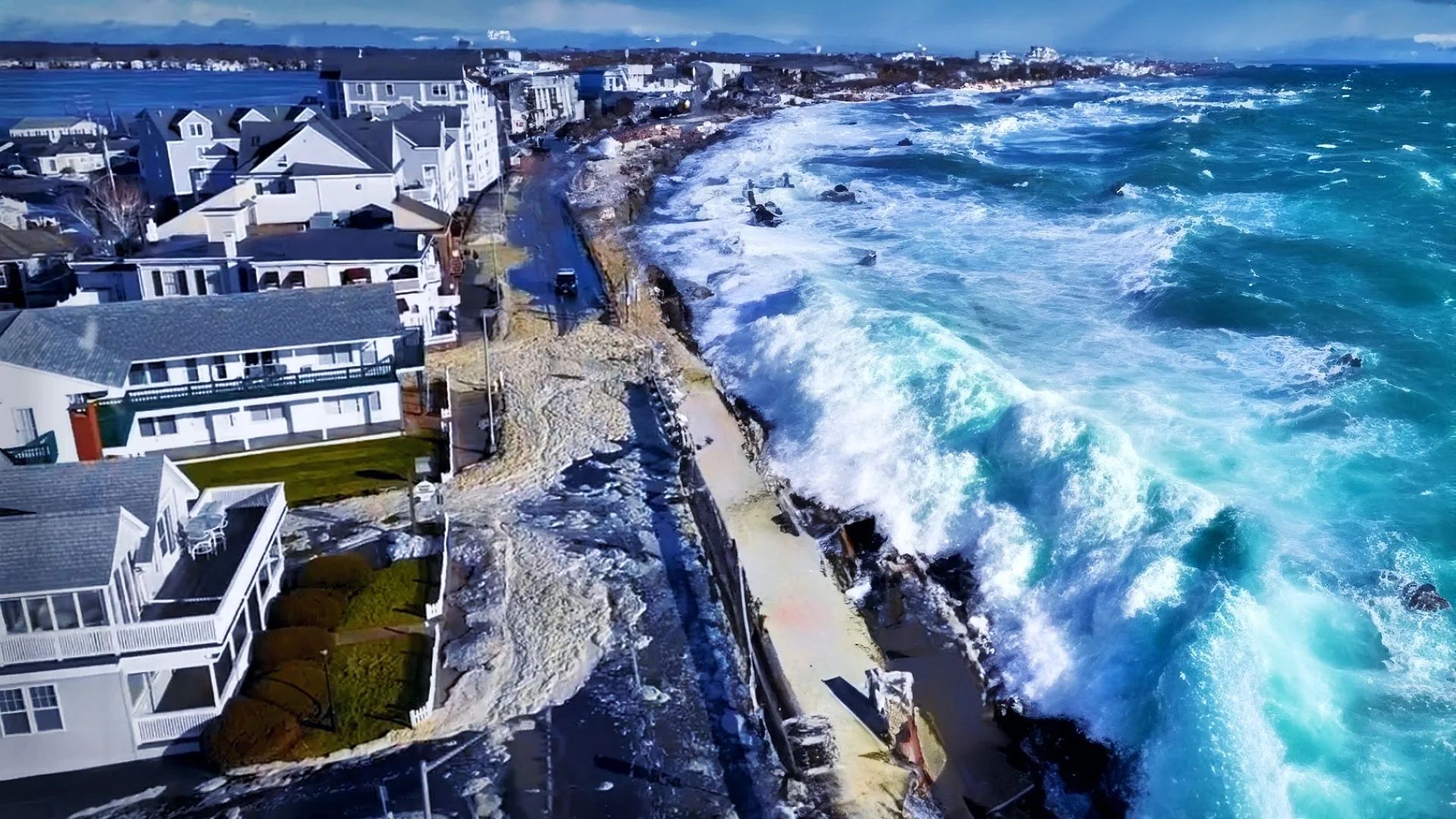
Southern California begins the week with its biggest weather danger coming from the ocean, not from a hurricane landfall. Marie has weakened from a hurricane to Tropical Storm Marie, but its long-period swell is still producing dangerous surf, powerful rip currents and coastal flooding from San Diego and Orange County north through Los Angeles, Malibu and Ventura County. The National Weather Service keeps High Surf and Coastal Flood Advisories in effect through 11 PM PDT Tuesday, September 8.
Southern California weather this week — at a glance
Biggest immediate hazard: high surf, rip currents and coastal flooding Monday–Tuesday.
Surf: 6–10 ft on exposed Orange/San Diego beaches; 5–8 ft with local sets to 12 ft from Los Angeles to Ventura.
Heat: warmest conditions Monday–Wednesday, especially away from the immediate beach.
Cooling: temperatures drop sharply toward the weekend.
Marie: the storm stays offshore and weakens, but the swell outlasts the storm’s intensity.
And this is not just a forecast threat.
At Newport Beach, lifeguards carried out 177 rescues on Saturday alone as Marie’s swell reached Southern California. Some south-facing beaches have already seen surf around 10 feet, while authorities described rip currents as life-threatening.
The week then changes character: dangerous surf dominates Monday and Tuesday, while inland and even some coastal grid locations become very warm. From Wednesday onward the swell should gradually ease, and by the weekend Southern California turns noticeably cooler and mostly dry.
Marie now: where is the storm?
As of 8 PM PDT Sunday, September 6, Marie had weakened to a tropical storm.
The National Hurricane Center placed the center near 24.2°N, 123.2°W, about 695 miles southwest of San Diego.
Maximum sustained winds had fallen to 70 mph, with Marie moving northwest at about 6 mph.
There are no tropical storm or hurricane watches or warnings for the California coast.
That distinction matters.
California is not facing Marie’s wind core.
It is facing the energy Marie has already transferred into the Pacific Ocean.
NHC expects Marie to continue weakening over cooler water and increasingly dry air, eventually becoming a post-tropical remnant low around midweek. But its swells will continue affecting Southern California for another couple of days.
Current Southern California warnings
For Orange County and San Diego County, NWS forecasts breaking waves of:
6–10 feet on south- and southwest-facing beaches, with 4–7 feet on west-facing beaches.
Strong rip currents and longshore currents are expected, along with minor coastal flooding around high tide. The High Surf Advisory and Coastal Flood Advisory remain valid through Tuesday night.
Farther north, conditions may be locally even rougher.
For Los Angeles County beaches, Malibu, Ventura County and the Channel Islands, NWS expects generally 5–8 foot breaking waves with local sets up to 12 feet, especially on south-facing shores. Moderate coastal flooding and potentially life-threatening rip currents are possible.
The timing of high tide makes Monday and Tuesday especially important.
Around Los Angeles County, high tide is forecast near 7 feet Monday evening and around 7.2 feet Tuesday evening. Around La Jolla, tides rise to approximately 6.7 feet Monday and 6.8 feet Tuesday. Higher tide plus large swell increases the chance of water reaching vulnerable parking areas, walkways and low-lying roads.
Newport Beach remains one of the main locations to watch because its south-facing shoreline is highly exposed to Marie’s swell.
Location
Peak temperature
Strongest gust
Weekly rain signal
Main coastal threat
Mon Sep. 7
90 / 71°F — 32 / 22°C
0 in / 0 mm
18 mph / 28 km/h
High surf, rip currents, coastal flooding
Tue Sep. 8
92 / 71°F — 34 / 21°C
Trace
19 mph / 30 km/h
High surf continues; high-tide flooding risk
Wed Sep. 9
92 / 79°F — 34 / 26°C
Trace
11 mph / 18 km/h
Swell begins easing; hot and humid
Thu Sep. 10
87 / 77°F — 31 / 25°C
0
12 mph / 19 km/h
Warm, mostly dry
Fri Sep. 11
83 / 74°F — 28 / 23°C
0
13 mph / 21 km/h
Gradual cooling
Sat Sep. 12
78 / 71°F — 26 / 22°C
0
15 mph / 25 km/h
Cooler coastal weather
Sun Sep. 13
78 / 70°F — 25 / 21°C
0
15 mph / 24 km/h
Mostly quiet
Source: Weather Forecaster forecast model, fresh September 7 run.
One important caveat: Weather Forecaster grid temperatures can run hotter than the immediate beach itself, particularly during weak sea-breeze conditions when a grid cell includes warmer inland terrain.
The official local coastal forecast is therefore useful for beach-level temperature, while Weather Forecaster is especially useful here for tracking the week’s broader temperature trend.
The trend itself is very clear:
hot Monday–Wednesday → sharp cooling toward the weekend.
Newport Beach: 177 rescues in one day
Marie has already produced one of the most striking coastal-weather stories of the weekend.
Newport Beach lifeguards reported 177 rescues on Saturday.
The local lifeguard battalion chief described red-flag conditions across the beach and warned that powerful currents were moving both along the shoreline and directly out to sea.
That number matters because the biggest hazard is not necessarily the visible height of the wave.
A person can look at an 8-foot wave and understand that it is large.
A rip current is much harder to recognize from shore.
It can rapidly pull even a strong swimmer away from the beach.
This is why NWS is advising inexperienced swimmers to stay out of the water while the advisory remains active.
Table 2: Southern California coastal hotspots
Location
Peak temperature
Strongest gust
Weekly rain signal
Main coastal threat
Newport Beach
92°F / 34°C Tue–Wed
19 mph / 30 km/h
Essentially dry
6–10 ft surf, rip currents, flooding
Huntington Beach
88°F / 31°C Tue
21 mph / 34 km/h Tue
Essentially dry
High surf and strong currents
Long Beach
99°F / 37°C Tue\*
28 mph / 45 km/h Tue
Essentially dry
Coastal flooding, runoff/water quality concern
Santa Monica
96°F / 35°C Tue\*
20 mph / 33 km/h Mon
Essentially dry
5–8 ft surf, local sets to 12 ft
Oxnard / Ventura coast
89°F / 32°C Tue\*
17 mph / 27 km/h Mon
Essentially dry
5–8 ft surf, local sets to 12 ft, coastal flooding
San Diego
97°F / 36°C Mon\*
18 mph / 29 km/h Mon
Less than 0.05 in / 1 mm
6–10 ft south-facing surf, rip currents
\*Immediate beaches may stay cooler than the Weather Forecaster grid value because of marine influence and afternoon sea breezes.
Source for temperature, rainfall and wind: Weather Forecaster forecast model.
Source for surf hazards: National Weather Service San Diego and NWS Los Angeles/Oxnard.
Monday, September 7: one of the most dangerous beach days
Monday is still a high-risk ocean day.
The strongest combination is:
large Marie swell + very strong rip currents + unusually high evening tide.
Orange and San Diego County beaches remain under High Surf and Coastal Flood Advisories.
Malibu, Santa Monica, the Los Angeles County beaches and Ventura County are also under advisories, with NWS now allowing for local 12-foot sets on the most exposed south-facing shores.
The weather on land may look deceptively good.
That is part of the danger.
Warm temperatures, breaks of sunshine and little rain can make Monday feel like an ideal beach day while ocean conditions remain dangerous.
Sunny weather does not mean a safe ocean.
Tuesday, September 8: surf remains dangerous while heat peaks
Tuesday is the second major coastal-risk day.
NWS warnings currently continue through 11 PM Tuesday.
Tides are slightly higher than Monday in some areas, so coastal flooding remains possible around the evening high tide.
At the same time, Weather Forecaster shows the hottest temperatures of the week across much of the coastal corridor.
Newport Beach rises to roughly 92°F / 34°C.
Huntington Beach reaches around 88°F / 31°C.
The Los Angeles Basin may become considerably hotter away from the immediate shoreline.
This combination could bring large beach crowds precisely while the water remains hazardous.
That makes Tuesday another day when lifeguard warnings should be taken seriously.
Wednesday, September 9: Marie begins losing its grip
By Wednesday, Marie should be well into its weakening phase and approaching post-tropical status.
The official High Surf Advisories currently expire Tuesday night.
That does not mean Wednesday morning suddenly becomes completely safe.
Long-period swell can linger after the storm itself weakens.
But the trend should be toward smaller surf and slowly improving rip-current conditions.
Weather Forecaster keeps the region warm and almost entirely dry.
Thursday and Friday: quieter ocean, gradual cooling
By Thursday, the story shifts away from Marie.
Newport Beach falls from the low 90s earlier in the week to the upper 80s Thursday and low 80s Friday.
The same cooling pattern develops across Orange, Los Angeles and Ventura counties.
Marine influence strengthens again.
No significant rain event currently appears in the Weather Forecaster forecast.
Weekend: Southern California cools down
The biggest land-weather change arrives next weekend.
Newport Beach drops to around 78°F / 26°C Saturday and Sunday.
Huntington Beach falls into the mid-70s.
Oxnard and Ventura become even cooler, with afternoon temperatures around the low-to-mid 70s.
San Diego’s Weather Forecaster grid falls from roughly 97°F Monday to around 71°F by Sunday.
Again, the exact coastal values may be lower than the hottest grid estimates early in the week, but the cooling trend is very strong.
So this week has two very different halves:
Monday–Tuesday: dangerous Marie surf + hot weather.
Wednesday–Friday: swell gradually eases, still warm.
Weekend: much cooler and calmer.
What is happening right now?
Marie has already caused real impacts across Southern California.
Newport Beach recorded 177 rescues Saturday.
NWS has reported surf reaching around 10 feet on some south-facing beaches.
Seal Beach closed beachfront parking areas because of high surf and flooding concerns.
Long Beach issued a swimming advisory after runoff affected coastal water quality.
Authorities throughout the region continue urging people to stay away from jetties and rocks and to swim only near staffed lifeguard towers if entering the water at all.
For Los Angeles, Malibu and Ventura County, the latest NWS update now allows local wave sets around 12 feet through Tuesday.
Official warning vs model forecast
OFFICIAL NHC: Marie is now a tropical storm well offshore, about 695 miles southwest of San Diego as of Sunday evening. It is weakening and is not forecast to make landfall in Southern California. No tropical cyclone watches or warnings are in effect for California.
OFFICIAL NWS: High Surf and Coastal Flood Advisories remain in effect through Tuesday night for much of the Southern California coast. Surf reaches 6–10 feet in Orange/San Diego County and 5–8 feet with local sets up to 12 feet from Los Angeles/Malibu into Ventura County. Dangerous rip currents and coastal flooding are the primary threats.
WEATHER FORECASTER MODEL SIGNAL: The week is mostly dry. The main land-weather event is a very warm Monday–Wednesday followed by significant cooling into the weekend.
The strongest hazard is therefore not heavy rain or hurricane wind.
It is the ocean.
What should beachgoers do?
For Monday and Tuesday, inexperienced swimmers should stay out of the water.
Even experienced swimmers and surfers should remain near staffed lifeguard areas and follow local closures.
Stay off jetties, breakwaters and exposed rocks. Large sets can arrive suddenly and sweep people into the ocean.
Do not drive around coastal-flood barricades or through seawater covering roads.
And do not assume that Marie’s downgrade from hurricane to tropical storm means the surf danger has ended.
The storm weakens faster than the swell does.
That is the key message for Southern California this week.
Track Southern California weather in Weather Forecaster
Check hourly temperatures, wind, rain and local coastal conditions for Newport Beach, Los Angeles, San Diego and other Southern California locations in Weather Forecaster.
Tropical Storm Marie will stay far offshore and continue weakening, but Southern California remains in a dangerous surf window through Tuesday.
The immediate hotspots are:
Newport Beach, Huntington Beach and other Orange County beaches;
San Diego County’s south- and southwest-facing shores;
Long Beach and the Los Angeles County coast;
Malibu;
Oxnard and Ventura County.
The most dangerous combination occurs Monday and Tuesday, when large swell overlaps with high tides.
After that, Marie’s influence fades.
By the weekend, Southern California should be substantially cooler, mostly dry and much calmer.
Sources
Sources: Weather Forecaster forecast model; National Hurricane Center; National Weather Service San Diego; National Weather Service Los Angeles/Oxnard; Associated Press.
The Founder and Chief Meteorologist at Pogodnik.com. With over 15 years of operational experience in synoptic analysis and climate forecasting, he specializes in storm tracking, magnetic storms, and atmospheric dynamics. A recognized expert in Ukraine’s meteorological sector, he maintains strategic collaborations with global agencies, including NOAA and ECMWF, to ensure high-precision data integration. His analytical reviews and scientific contributions are regularly featured in leading media outlets dedicated to weather science and environmental trends.