Atlantic Hurricane Season 2026: NOAA, Copernicus and WMO Signals, Storm Names in the US and Europe, and What Forecasters Expect
The 2026 Atlantic hurricane season has not officially started yet, but meteorologists are already watching the large-scale climate signals that often shape how active, dangerous and unpredictable the season may become. This year, the Atlantic enters spring with a warm ocean background, a fading La Niña, rising uncertainty around ENSO-neutral conditions, and a growing chance that El Niño could begin to re-emerge later in the warm season. That mix does not support easy headlines. It supports caution.
The Atlantic is quiet for now, and as of mid-March 2026 there are no tropical cyclones being tracked by the National Hurricane Center. But the basin is entering pre-season with warm sea-surface temperatures, a fading La Niña and a likely transition to ENSO-neutral through spring and early summer. That keeps the 2026 signal mixed: there is enough oceanic heat to support dangerous storms, but the atmosphere has not yet committed to a clearly hyperactive pattern. Europe should also watch the season closely, not only because of ex-hurricanes and autumn windstorms, but because drought, wildfire danger, heavy rain, flood risk and Atlantic-driven storm tracks increasingly overlap. Below is the full meteorological setup, the official storm-name lists for the Atlantic, Eastern Pacific and Central Pacific, and the main storm-name systems used across Europe.

Is hurricane season 2026 already active?
No. As of March 11, 2026, the Atlantic basin is quiet. The National Hurricane Center reports that there are no tropical cyclones in the Atlantic at this time, and routine Tropical Weather Outlooks will resume on May 15 unless a special situation develops earlier. The official Atlantic hurricane season still runs from June 1 through November 30. That matters because it means any serious March assessment of the season must be framed as an early outlook based on background signals, not as a final forecast of named storms, hurricanes or landfalls.
That distinction is important for both weather journalism and operational forecasting. A quiet basin in March does not tell you whether August and September will be dangerous. Tropical cyclone seasons are shaped far more by the evolving ocean-atmosphere background than by whether a random off-season disturbance appears on satellite imagery in late winter. For that reason, the most valuable way to rewrite a hurricane-season article for 2026 is to focus on the real drivers that forecasters are watching right now.
The key climate signal for 2026: La Niña is fading
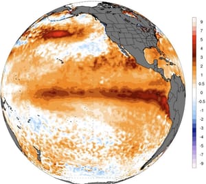
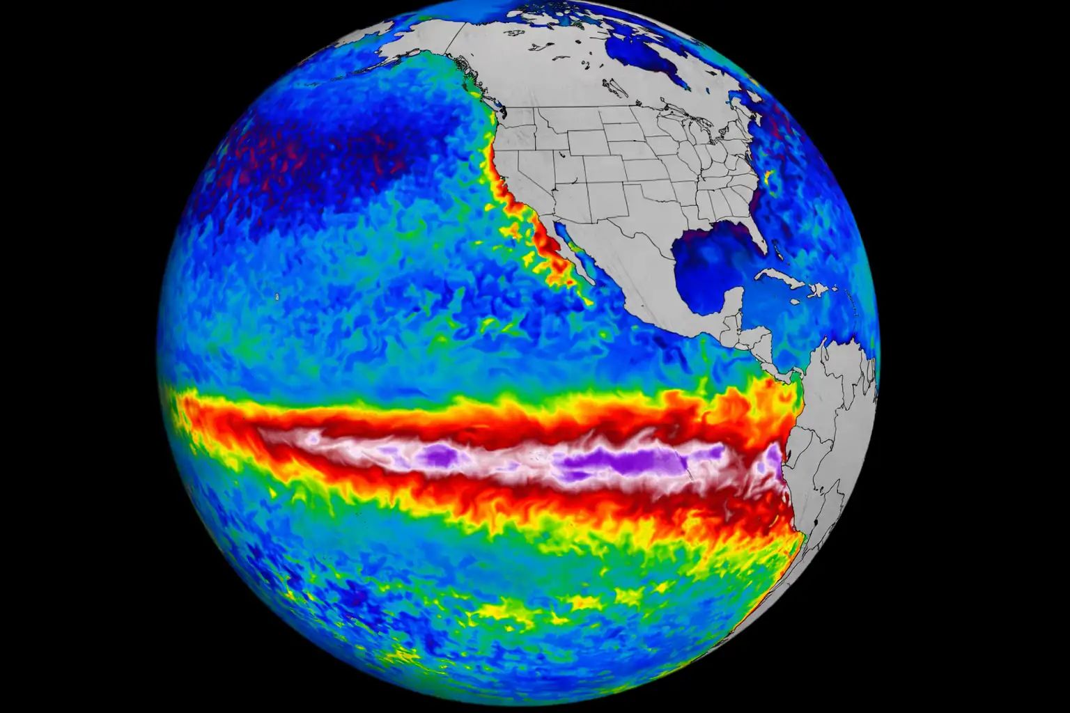
The biggest pre-season atmospheric storyline is ENSO. NOAA‘s Climate Prediction Center says a transition from La Niña to ENSO-neutral is expected during February-April 2026, with ENSO-neutral likely to persist through the Northern Hemisphere summer. WMO is sending a similar message. Its early March update says weak La Niña is fading, neutral conditions are expected until July, and the chance of El Niño gradually rises later in the warm season. In other words, the Pacific is no longer locked into a strong La Niña-style background that would automatically favor a more active Atlantic.
That does not mean the Atlantic is safe. It means the signal is more complicated. La Niña usually lowers vertical wind shear across parts of the Atlantic and often creates a friendlier environment for tropical cyclones. El Niño often does the opposite by increasing upper-level winds and making it harder for storms to organize or intensify efficiently. But spring is notoriously difficult for ENSO forecasting. This is the so-called spring predictability barrier, when confidence in long-range Pacific evolution drops. So the 2026 setup is not a clean one. It is transitional, and transitional years often demand more careful language.
The Atlantic is still warm enough to matter
Even with the Pacific in transition, the Atlantic itself remains important. WMO’s Global Seasonal Climate Update for March-April-May 2026 says the North Tropical Atlantic and South Tropical Atlantic remain slightly above average, while warmth also persists across the extratropical North Atlantic. Copernicus reports that the average sea-surface temperature for February 2026 over 60°S-60°N was 20.88°C, tied for the second-highest February value on record. That does not automatically guarantee a hyperactive Atlantic season, but it does mean the basin is not entering 2026 from a cool or energy-starved background.
This is one of the most important corrections to sensational hurricane-season writing. A warm Atlantic does not guarantee a record year. But it raises the ceiling. If atmospheric conditions become supportive during peak season, especially from August into October, the basin would still have sufficient oceanic fuel to produce high-end hurricanes, rapid intensification episodes and destructive rainfall events. Warm water is not the whole story. But without it, a dangerous season is harder to build. With it, the threat remains very real.
What forecasters can and cannot say in March 2026
At this point in the calendar, the honest professional answer is not “2026 will be explosive” and not “2026 will be mild.” The signal is mixed. Warm Atlantic waters lean supportive. A fading La Niña and likely ENSO-neutral summer do not strongly suppress the basin. But rising odds of El Niño later in the season introduce uncertainty, especially for late-summer and autumn storm behavior. That is why the best early interpretation is this: the Atlantic has enough heat to generate dangerous hurricanes in 2026, but the atmospheric pattern has not yet provided a clean green light for a clearly above-normal season.
Why one landfall can define an entire season
Another mistake common in weather coverage is treating storm counts as the whole story. They are not. A season with a moderate number of named storms can still become catastrophic if one major hurricane hits the Gulf Coast, Florida, the Carolinas, the Caribbean or Atlantic Canada at the wrong angle, speed and tide cycle. Tropical storms can also be devastating through freshwater flooding, inland wind damage, tornadoes and prolonged power outages. Seasonal outlooks describe basin-wide activity. They do not tell a family in Louisiana, Cuba, Puerto Rico or the Outer Banks whether they will be hit.
That is why preparedness messaging should begin long before the final seasonal numbers are issued. Even in a mixed-signal year, the consequences of one bad landfall are enough to justify preparation.
Why Europe should care about Atlantic hurricane season 2026
Europe does not experience hurricane season in the same way as the United States or the Caribbean, but it is still part of the wider North Atlantic risk picture. Ex-tropical cyclones can transition into powerful post-tropical systems that affect Ireland, the United Kingdom, Iberia, France, the North Sea region and Scandinavia. In some years, Atlantic tropical systems also reshape downstream jet-stream patterns, rainfall distribution and early autumn windstorm risk.
There is another reason Europe matters in a 2026 storm article: compound hazards. The European Forest Fire Information System shows that the 2025 wildfire season in the European Union ended with a total burnt area of 1,034,552 hectares, with especially high activity in Portugal, Spain, southern France, southern Italy, Greece, Türkiye, Ukraine and parts of the UK. That means European risk communication in 2026 should not focus only on named autumn storms. It should also consider how heat, drought, wildfire exposure, later heavy rain, flood episodes and Atlantic storm tracks can interact within the same broad climate season.
What is the early professional read on the 2026 season?
The most balanced meteorological interpretation is this. The Atlantic is not entering 2026 under a strongly suppressive background. Ocean temperatures remain warm enough to support serious storms. ENSO is shifting away from La Niña and toward neutral, which removes one classic reason for a highly active Atlantic but does not shut the basin down. If El Niño develops later than expected, the core of the Atlantic season could still become dangerous. If El Niño develops faster or stronger, vertical wind shear could become a more effective limiting factor. Either way, March is still too early for clean confidence.
So the responsible headline is not panic and not complacency. It is uncertainty with meaningful risk.
Official 2026 storm names in the United States basins
Atlantic storm names for 2026
The Atlantic list for 2026 is fixed in advance under the WMO naming system. These are the names assigned to the 2026 Atlantic season in order:
| # | 2026 Atlantic storm names |
|---|---|
| 1 | Arthur |
| 2 | Bertha |
| 3 | Cristobal |
| 4 | Dolly |
| 5 | Edouard |
| 6 | Fay |
| 7 | Gonzalo |
| 8 | Hanna |
| 9 | Isaias |
| 10 | Josephine |
| 11 | Kyle |
| 12 | Leah |
| 13 | Marco |
| 14 | Nana |
| 15 | Omar |
| 16 | Paulette |
| 17 | Rene |
| 18 | Sally |
| 19 | Teddy |
| 20 | Vicky |
| 21 | Wilfred |
These Atlantic lists rotate every six years. A name is only changed if a storm becomes so deadly or destructive that using the same name again would be inappropriate. That is why the list is usually stable, with occasional replacements after major disasters.
Eastern Pacific storm names for 2026
The Eastern Pacific also uses a fixed rotating list. The 2026 names are:
| # | 2026 Eastern Pacific storm names |
|---|---|
| 1 | Amanda |
| 2 | Boris |
| 3 | Cristina |
| 4 | Douglas |
| 5 | Elida |
| 6 | Fausto |
| 7 | Genevieve |
| 8 | Hernan |
| 9 | Iselle |
| 10 | Julio |
| 11 | Karina |
| 12 | Lowell |
| 13 | Marie |
| 14 | Norbert |
| 15 | Odalys |
| 16 | Polo |
| 17 | Rachel |
| 18 | Simon |
| 19 | Trudy |
| 20 | Vance |
| 21 | Winnie |
| 22 | Xavier |
| 23 | Yolanda |
| 24 | Zeke |
Central Pacific storm names likely next in 2026
The Central Pacific does not reset to A every year in the same way as the Atlantic or Eastern Pacific lists. Instead, the names are used sequentially across four rotating lists. Because the 2025 Central Pacific season already used Iona and Keli, the next names in sequence entering 2026 are:
| # | Next Central Pacific names in sequence |
|---|---|
| 1 | Lala |
| 2 | Moke |
| 3 | Nolo |
| 4 | Olana |
| 5 | Pena |
| 6 | Ulana |
| 7 | Wale |
This is an important technical detail because many general-interest articles incorrectly assume the Central Pacific starts from a fresh alphabetical list each year. It does not. It continues from the next unused name in the sequence.
How hurricane names are chosen in the US basins
In the Atlantic and Eastern Pacific, the lists are pre-approved, international and cyclical. They are maintained through the World Meteorological Organization system. Names are reused every six years unless retired. Retirement happens only when a storm becomes so deadly or costly that reusing the name would be insensitive and confusing. In early March 2026, WMO announced that the name Melissa had been retired and replaced with Molly for future use, which is a current example of how the system updates after a destructive storm.
If a tropical cyclone forms outside the traditional season, it still takes the next name based on the calendar and the relevant naming list. In the Central Pacific, names are simply taken one after another from the running list.
Official storm-name systems used in Europe
Europe does not have one single continent-wide storm list. It uses regional operational naming groups, coordinated across national meteorological services. This is one of the most misunderstood points in storm reporting. There is no one universal “Europe 2026 storm names list” equivalent to the Atlantic hurricane list. Instead, different groups name storms depending on where impacts are expected first and which warning service issues the first qualifying alert.
Western Europe group: UK, Ireland and the Netherlands
The Western Europe group led by the Met Office, Met Éireann and KNMI uses the following 2025/26 list:
| # | Western Europe storm names 2025/26 |
|---|---|
| 1 | Amy |
| 2 | Bram |
| 3 | Chandra |
| 4 | Dave |
| 5 | Eddie |
| 6 | Fionnuala |
| 7 | Gerard |
| 8 | Hannah |
| 9 | Isla |
| 10 | Janna |
| 11 | Kasia |
| 12 | Lilith |
| 13 | Marty |
| 14 | Nico |
| 15 | Oscar |
| 16 | Patrick |
| 17 | Ruby |
| 18 | Stevie |
| 19 | Tadhg |
| 20 | Violet |
| 21 | Wubbo |
This naming season runs from September 1 to August 31. A storm is named when it is expected to produce medium or high impacts in one of the partner countries, typically corresponding to amber or red warning thresholds. Wind is the main trigger, but rain and snow impacts can also be considered.
South-West Europe group: Spain, Portugal, France, Belgium, Luxembourg and Andorra
The South-West group uses its own 2025/26 list:
| # | South-West Europe storm names 2025/26 |
|---|---|
| 1 | Alice |
| 2 | Benjamin |
| 3 | Claudia |
| 4 | Davide |
| 5 | Emilia |
| 6 | Francis |
| 7 | Goretti |
| 8 | Harry |
| 9 | Ingrid |
| 10 | Joseph |
| 11 | Kristin |
| 12 | Leonardo |
| 13 | Marta |
| 14 | Nils |
| 15 | Oriana |
| 16 | Pedro |
| 17 | Regina |
| 18 | Samuel |
| 19 | Therese |
| 20 | Vitor |
| 21 | Wilma |
In this group, the depression is named when it is expected to trigger at least an orange wind warning in one of the participating countries. The meteorological service that expects to issue the first qualifying warning assigns the next name from the pre-agreed list. The same storm keeps that name for its entire life cycle.
Northern Europe group: Scandinavia from 2026
From January 1, 2026, Denmark, Sweden and Norway moved to a shared public naming list. The names are:
| # | Scandinavia shared storm names |
|---|---|
| 1 | Anna |
| 2 | Björn |
| 3 | Cecilia |
| 4 | Daniel |
| 5 | Elena |
| 6 | Filip |
| 7 | Gunilla |
| 8 | Hugo |
| 9 | Ida |
| 10 | Johan |
| 11 | Karin |
| 12 | Lukas |
| 13 | Miriam |
| 14 | Noah |
| 15 | Olivia |
| 16 | Pelle |
| 17 | Ronja |
| 18 | Sture |
| 19 | Tonje |
| 20 | Urban |
| 21 | Vilma |
| 22 | Ymer |
Each country uses slightly different criteria. Sweden may name major snowstorms, heavy rain and flood-producing systems with major societal consequences. Denmark names warned storms with mean winds of at least 25 m/s. Norway uses a consequence-based warning structure and can apply names to red-level wind, rain, snow or water-level events. This means the shared list may be used differently by each country.
Central Europe: Berlin naming tradition and why it matters
Central Europe introduces a different layer of complexity. The Berlin Weather Map and the Wetterpate system associated with Freie Universität Berlin name high-pressure and low-pressure systems over Europe. In even-numbered years such as 2026, low-pressure systems receive female names and high-pressure systems receive male names. In odd-numbered years the pattern reverses. This is not the same as the operational storm-warning lists used by EUMETNET groups, but it still appears frequently in media coverage across Germany and neighboring countries.
So if a reader asks for “all 2026 storm names in Europe,” the technically correct answer is that Europe does not have one single fixed storm list. Western Europe, South-West Europe and Scandinavia have pre-published operational lists, while parts of Central Europe also use the Berlin naming convention for pressure systems. Those systems overlap in media language, which is why confusion is so common.
How storms are named in Europe
The basic principle is impact-based naming. In the UK-Ireland-Netherlands group, storms are named when medium or high impacts are expected. In the South-West group, a storm gets a name when one of the participating services expects to issue an orange or red wind alert first. In Scandinavia, each national service applies its own consequence thresholds. The purpose is not branding. It is public safety. A named storm is easier to communicate, easier to remember and easier for emergency managers, media, transport operators and the public to follow across several forecast cycles.
Another important operational rule is that storms already named by one recognized group are usually not renamed by another group. If the remnants of an Atlantic hurricane reach Europe, the established tropical name is generally retained rather than replaced with a new local one.
The 2026 Atlantic hurricane season is not active yet, and there is no honest reason to pretend otherwise. But the season is already meteorologically interesting. A fading La Niña, likely ENSO-neutral conditions into summer, a warm Atlantic background and the chance of El Niño emerging later create a setup that is neither cleanly hostile nor fully favorable for tropical cyclones. The basin still has enough oceanic heat to produce dangerous hurricanes if the atmosphere cooperates. Europe, meanwhile, should watch the season through the broader lens of Atlantic storm tracks, ex-tropical systems, flood episodes, drought stress and wildfire vulnerability.
That is the real early message for 2026: not hype, not dismissal, but a season worth watching closely from the very start.