Arthur Remnants Trigger Gulf Coast Flash Flood Emergency: Life-Threatening Rainfall Threat
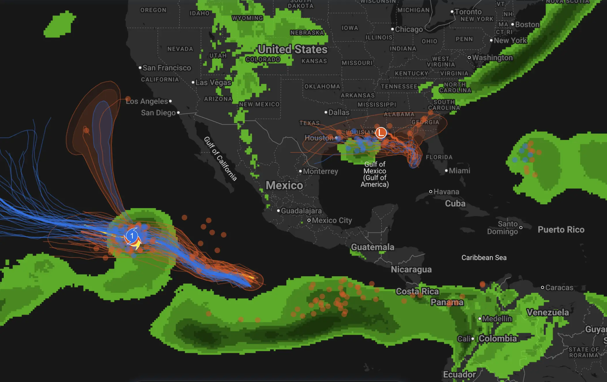
Arthur has lost its tropical-storm status, but the most dangerous part of the system is still unfolding. A deep tropical moisture plume left behind by Arthur is feeding repeated thunderstorms across the central Gulf Coast, creating a high-end flash flood setup from Louisiana and Mississippi toward Alabama and the Florida Panhandle.
The main threat is not wind. It is rainfall. The National Weather Service Weather Prediction Center has highlighted a dangerous excessive rainfall setup for the central Gulf Coast, where storms may repeatedly move over the same areas and produce rainfall rates of several inches per hour. New Orleans, southern Mississippi, Mobile, Pensacola and nearby communities should watch flash flood warnings closely.
Arthur is no longer a tropical cyclone, but the flood threat remains life-threatening. When a tropical system weakens over land, the wind headline can fade quickly while the rainfall shield remains active. That is exactly the danger now: saturated ground, repeated storm bands and extremely efficient tropical downpours.
Arthur is post-tropical, but the moisture plume is still dangerous
The National Hurricane Center reported that Arthur degenerated into a low pressure area along the upper Texas coast. Coastal tropical watches and warnings were discontinued, and the system weakened inland. But the remnants are still carrying a very deep plume of tropical moisture across the southeastern United States.
That moisture is expected to produce widespread heavy rainfall from the Mid and Upper Texas coast east-northeast into Louisiana, Mississippi, Alabama, western Georgia and the Florida Panhandle. Local rainfall totals may reach dangerous levels where storms train over the same communities for several hours.

Why the Gulf Coast flood setup is so efficient
This setup is dangerous because the atmosphere is loaded with moisture and energy. WPC describes a strong low-level jet near 850 hPa pushing deep Gulf moisture into the coast. Precipitable water values are above 2.6 inches, and instability over the Gulf is high enough to support intense, efficient rain-producing thunderstorms.
In simple terms, the atmosphere can convert moisture into rainfall very quickly. The strongest cells can produce rainfall rates near 3 inches per hour. In urban areas or already saturated watersheds, that kind of rainfall can overwhelm drainage systems within a short time.
The most dangerous corridor
| Area | Main threat | Why it is dangerous | What to watch |
|---|---|---|---|
| Southeast Louisiana | Flash flooding, river rises, urban flooding | Repeated storms may move over already wet areas, and drainage can be overwhelmed quickly. | Flash flood warnings, road closures, bayous, canals and low-lying neighborhoods. |
| New Orleans metro | Urban flash flooding | Heavy rain rates can exceed drainage capacity, especially if bands stall nearby. | Underpasses, low streets, pump capacity, local emergency alerts. |
| Southern Mississippi | Training storms and creek flooding | Multiple waves of storms may track across the same areas, raising streams and small rivers quickly. | County warnings, water-covered roads, rapidly rising creeks. |
| Southern Alabama | Heavy rain, flash flooding, possible severe storms | Moisture remains deep while storm lines shift eastward into the state. | Mobile-area warnings, flood-prone roads, lightning and brief tornado potential. |
| Mobile, Alabama | Life-threatening flash flooding | WPC specifically notes that urban areas including Mobile could see dangerous flooding if training storms persist. | Local NWS alerts, flooded intersections, coastal and inland drainage issues. |
| Pensacola and Florida Panhandle | Flash flooding later in the day and evening | The trailing rain band may drift toward the Panhandle, bringing repeated downpours. | Flash flood warnings, road washouts, beach and rip current hazards. |
Training storms and backbuilding convection: why flooding can escalate fast
Training storms happen when thunderstorm cells repeatedly move over the same area, like train cars passing over the same track. Backbuilding occurs when new storms keep forming on the upstream side of an existing storm line, allowing heavy rain to continue over or near the same region.
This is the core danger with Arthur’s remnants. The rain shield is not just moving through once. Bands can reorganize, stall or rebuild along the Gulf Coast, especially from Louisiana and Mississippi toward Alabama and the Florida Panhandle. If the axis stalls for only a few hours, rainfall totals can climb quickly.
What could change in the forecast
The biggest uncertainty is the exact placement of the heaviest training band. A shift of only 50 to 100 miles can decide which cities see the worst flooding. If the axis remains farther west, Louisiana and Mississippi may take the hardest hit. If it shifts east faster, Mobile, Pensacola and the Florida Panhandle could become the main impact zone.
The flood threat is already high-confidence, but the exact local maximum will depend on where storms train longest. Residents should not focus only on the center of Arthur’s remnants. The most dangerous flooding may occur well away from the old center, beneath persistent rain bands.
Rainfall amounts: how much could fall?
| Rainfall signal | Meaning | Flood impact |
|---|---|---|
| 5 to 10 inches | Broad storm-total rainfall potential across the Gulf Coast and Southeast corridor | Flash flooding, flooded roads, swollen creeks and urban drainage problems. |
| Near 12 inches | Possible in parts of the highest-risk zone where storms repeat | Significant flash flooding becomes more likely, especially on saturated ground. |
| Near 20 inches locally | Extreme local maximum possible in the most persistent rain bands | Dangerous to life-threatening flooding, road closures, water rescues and river rises. |
| Rainfall rates near 3 inches per hour | Possible in the strongest tropical downpours | Flooding can begin quickly, even before storm totals become extreme. |
Why this is more than a coastal rainstorm
Arthur’s remnants are interacting with a larger weather pattern over the Southeast. Deep tropical moisture is moving inland while a frontal boundary helps focus thunderstorm development. This can spread the flood threat beyond beaches and coastal towns into inland communities, river basins and urban corridors.
Flooding is also more likely because parts of the region have already received heavy rain in recent days. When soils are nearly saturated, new rainfall runs off faster into streets, creeks, rivers and drainage systems.
Additional hazards: tornadoes, surf and rip currents
Although flooding is the dominant hazard, Arthur’s remnants can still produce other threats. A few tornadoes are possible in parts of the Southeast, especially where tropical rain bands maintain enough low-level spin. Along the Gulf Coast, swells and rip currents can remain dangerous even after the tropical storm label disappears.
People near the coast should avoid entering rough surf, and drivers should treat flooded roads as life-threatening. Most flood deaths occur in vehicles, often when drivers underestimate the depth or force of moving water.
Safety checklist for the Gulf Coast
If a flash flood warning is issued, act immediately. Do not wait for water to reach your home or vehicle. Move to higher ground, avoid flooded streets and follow local emergency instructions.
| Situation | What to do | Why it matters |
|---|---|---|
| Flash flood warning | Move to higher ground immediately | Water can rise quickly, especially near creeks, canals and low roads. |
| Flooded road | Turn around and choose another route | The road may be washed out, and moving water can carry vehicles away. |
| Heavy rain at night | Avoid unnecessary travel | Flooded roads are much harder to see in darkness. |
| Urban flooding | Avoid underpasses and low intersections | Water depth can increase rapidly in city drainage corridors. |
| Power outages | Keep phones charged and use flashlights instead of candles | Flooding and storms can disrupt electricity and emergency communication. |
| Coastal surf | Stay out of rough water and follow beach flag warnings | Rip currents can remain life-threatening after the storm weakens. |
Impact outlook by state
| State | Flood concern | Key areas to monitor |
|---|---|---|
| Louisiana | High flash flood risk where rain bands train or backbuild | New Orleans, Baton Rouge area, southeast Louisiana, parishes near coastal drainage basins. |
| Mississippi | High risk for repeated downpours and creek flooding | Southern Mississippi, Gulfport-Biloxi corridor, inland counties with saturated soils. |
| Alabama | Flash flooding risk increasing as storms shift east | Mobile, southern Alabama, central Alabama and communities near flood-prone streams. |
| Florida Panhandle | Flood risk may grow later as trailing storms move in | Pensacola, coastal Panhandle, low roads, beaches and drainage-sensitive neighborhoods. |
| Georgia | Heavy rain possible as moisture spreads inland | Western Georgia and areas already dealing with wet ground. |
| Texas | Lingering flooding and runoff concerns | Upper Texas coast, southeast Texas, low-lying and recently flooded locations. |
How certain is the flood forecast?
The forecast confidence is high that Arthur’s remnants will create a dangerous flood setup across the Gulf Coast and Southeast. The combination of deep tropical moisture, strong low-level inflow, high instability, saturated soils and repeated storms supports a significant flash flood threat.
The main detail that can still change is the placement of the heaviest rain axis. That means warnings may shift through the day as radar trends show where storms are training longest. People from Louisiana and Mississippi to Alabama and the Florida Panhandle should monitor local alerts closely.
Pogodnik app
Use Pogodnik to monitor storms, heavy rain, wind and local weather changes before dangerous conditions arrive. Check hourly forecasts, precipitation, wind, cloud cover and local weather updates for your location. Download the Pogodnik Android app: https://play.google.com/store/apps/details?id=com.bitltd.pogodnik
Main takeaway
Arthur’s tropical phase is over, but the flood threat is not. The remnants are still feeding a dangerous Gulf Coast rainfall event, with training storms, backbuilding convection and extremely efficient tropical downpours capable of producing life-threatening flash flooding.
The highest concern runs from Louisiana and Mississippi toward Alabama and the Florida Panhandle. The exact axis may shift, but the message is clear: do not drive into floodwater, keep alerts enabled and follow local warnings immediately.
FAQ: Arthur remnants and Gulf Coast flash flooding
Is Arthur still a tropical storm?
No. Arthur has degenerated into a post-tropical low pressure area, but its moisture plume is still producing dangerous heavy rainfall.
Why is flooding still dangerous if Arthur weakened?
Weak tropical systems can still carry deep moisture. When rain bands train over the same area, flash flooding can become the main hazard even after winds decrease.
Where is the highest flood risk?
The highest risk is focused along the central Gulf Coast, especially parts of Louisiana, Mississippi, southern Alabama and the Florida Panhandle.
Could New Orleans, Mobile or Pensacola flood?
Yes. These urban areas are within the broader zone where repeated storms may produce dangerous flash flooding if rain bands stall or backbuild nearby.
How much rain could fall?
Many areas may receive 5 to 10 inches of rain, with higher local totals possible. In the most persistent rain bands, totals could locally approach 20 inches.
What should people do during a flash flood warning?
Move to higher ground, avoid flooded roads, stay out of underpasses and follow instructions from local authorities. Never drive through moving water.
Severe Weather Chicago: Tornado Risk, 80 mph Winds and Rotating Supercells Threaten Illinois