Europe’s Heat Dome Is Becoming a Continental Emergency: Fires, Water Bans and Tropical Nights Spread
Europe’s latest heat dome is no longer only a temperature story. France has activated an emergency response for extreme heat, the Netherlands has restarted its National Heat Plan, Britain is facing an “extreme” wildfire risk alongside widening water restrictions, and Germany is counting the human cost of the record-breaking June heatwave. The dangerous pattern is expected to continue through the weekend and into the middle of July, with only uneven and often stormy relief.
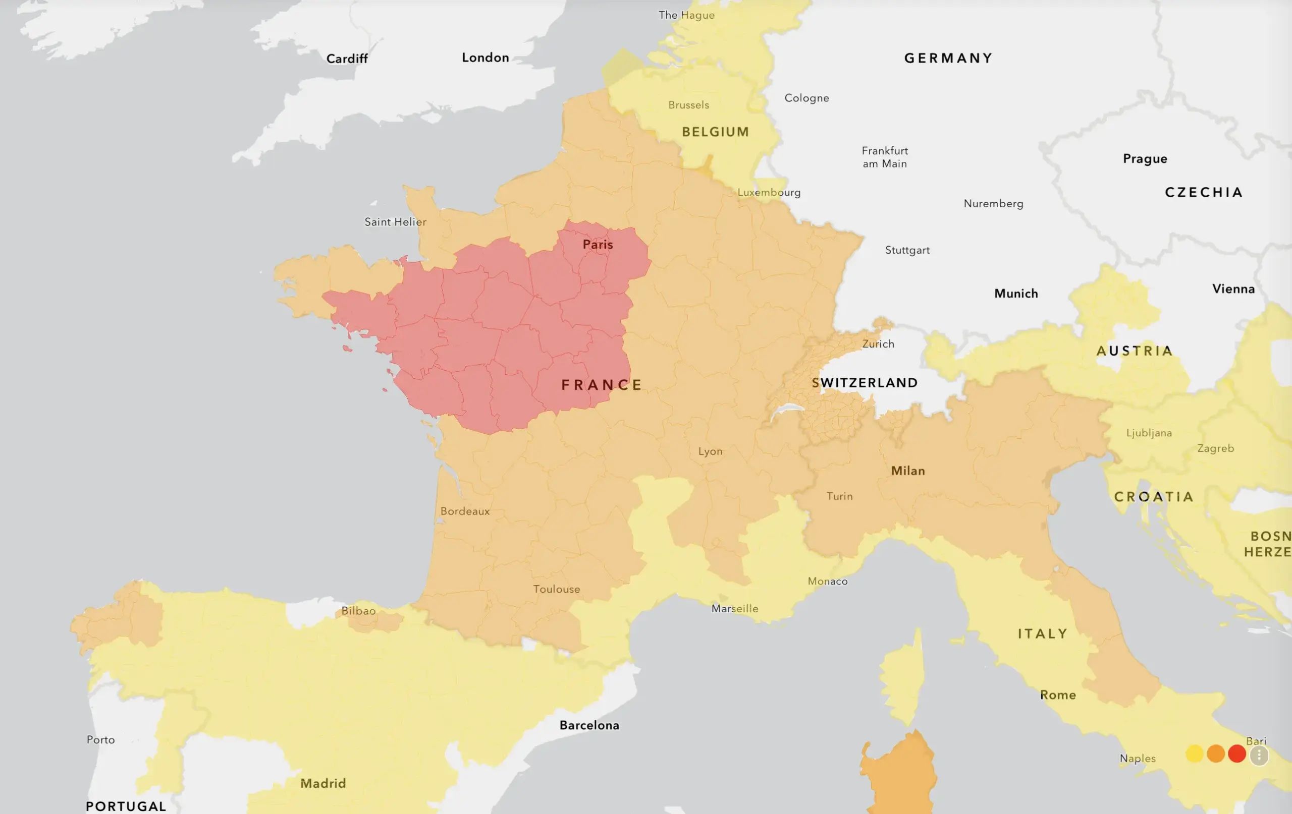
France: 24 departments are under red heat vigilance and 59 under orange on July 11. Maximum temperatures of 33–38°C are widespread, locally reaching 39°C, while nighttime lows remain near 18–24°C.
United Kingdom: temperatures reached 35.2°C in Derbyshire on Friday. Heat-health alerts remain active through Sunday, while London’s wildfire risk is expected to become extreme from Saturday to Monday.
Netherlands: the National Heat Plan has been activated again. Southern areas may reach 32°C this weekend and 33°C later next week, with very high UV exposure.
When could it cool: limited thunderstorm relief may begin in parts of France and southern Britain, but a broader shift toward cooler and more changeable conditions is most credible in the Netherlands from July 18 onward.
Europe heatwave 2026: the crisis in four numbers
24 French departments under red heat vigilance on July 11
35.2°C Temperature recorded at Coton in the Elms, Derbyshire
32–33°C Possible maximum temperatures in the Netherlands through July 16
5,120 Estimated heat-related deaths reported in Germany during the 2026 heat crisis
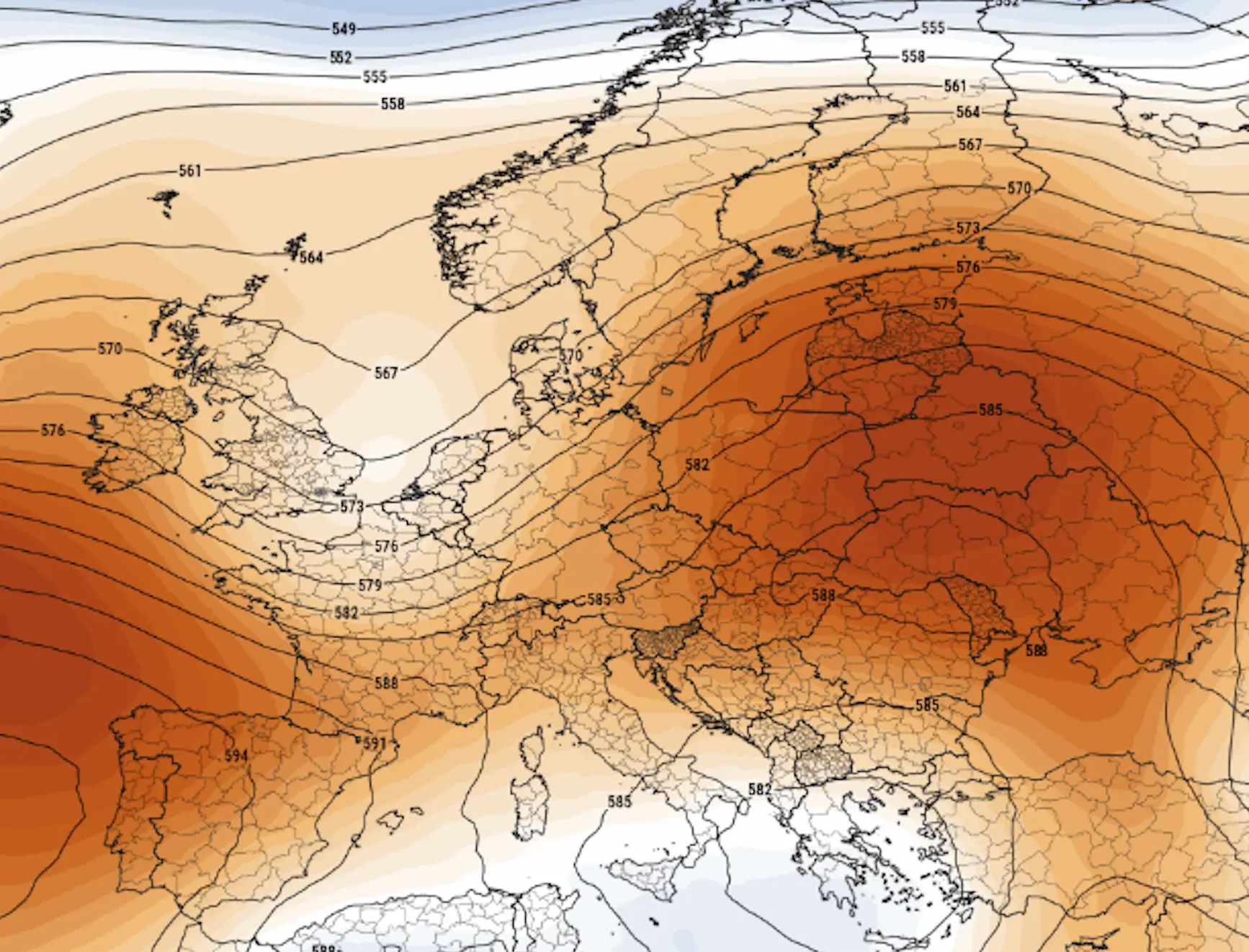
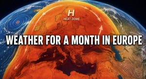
These events are connected by the same large-scale atmospheric pattern. A powerful ridge of high pressure has expanded across Western Europe, suppressing widespread rain and allowing hot air to remain trapped near the surface. Meteorologists often describe this structure as a heat dome or an omega blocking high.
Under this pattern, the ground and buildings heat up day after day. Overnight temperatures then remain unusually high, creating the “tropical nights” now dominating health and climate coverage across Europe. The danger is cumulative: the body, housing stock, transport networks and water systems lose their normal nighttime recovery period.
France activates its extreme heat emergency response
France has moved from heat warnings to emergency coordination. On July 10, the government activated its new Extreme Heat ORSEC response mechanism in departments placed under red alert. The system coordinates civil protection, health services, cooling centres, local government and support for isolated residents.
The escalation has been rapid. RSOE EDIS reported nine departments under red alert and 72 under orange on Friday. By Saturday, July 11, Météo-France had expanded red vigilance to 24 departments, with another 59 departments under orange heat vigilance.
Saturday’s forecast places much of France between 33°C and 38°C, locally close to 39°C. Paris was near 36°C on Friday afternoon, while Lyon and Toulouse reached around 37°C. Nighttime temperatures are also unusually high, commonly remaining between 18°C and 23°C and locally close to 24°C.
France is not completely dry. Thunderstorms are expected across parts of the southeast, the Alps, Massif Central and Corsica, where locally heavy rainfall, small hail and strong wind gusts may develop. But these storms will bring only local and temporary relief rather than ending the national heatwave.
The RSOE report says the current heatwave began on July 4 and is expected to continue at least through Tuesday, July 14, with another rise in temperature on Sunday. During the first week of July, 9,921 hectares burned in France — nearly three times the area recorded during the same period a year earlier.
Bastille Day, the Tour de France and wildfire danger converge
The French heat emergency is colliding with one of the country’s busiest public-event periods. Several Bastille Day fireworks displays have been cancelled because of wildfire danger, including events in Hérault and Vendée.
Wildfire conditions have also disrupted the Tour de France. Organisers restricted spectator access near a stage finish after a large fire in southern France forced emergency operations close to the race route.
This is a defining feature of Europe’s 2026 heat crisis: weather warnings are no longer isolated environmental notices. They are affecting national celebrations, sporting events, tourism, rail services, electricity generation and public safety at the same time.
UK heatwave: records, hosepipe bans and an extreme fire warning
The United Kingdom is experiencing another prolonged spell of very hot weather. Temperatures reached 35.2°C at Coton in the Elms in Derbyshire on Friday, making 2026 the first year in the UK record to produce six separate days at or above 35°C.
The year has also become the first to record temperatures of at least 35°C in three different calendar months. Nine days have reached or exceeded 34°C so far this summer.
Amber heat-health alerts are active across the North West, Yorkshire and the Humber, East Midlands, West Midlands, East of England, London, South West and South East. The North East remains under a yellow alert. The alerts are scheduled to continue until 9 p.m. on Sunday, July 12.
The Met Office expects central and southern England and Wales to record several consecutive days above 30°C. Wales and southwest England may reach around 32–34°C during the weekend. The focus of the heat is gradually shifting west, while some eastern coastal areas receive slightly cooler air from the sea.
Heat is now interacting with dry vegetation and wind. The London Fire Brigade expects the wildfire threat in the capital to rise from elevated to extreme between Saturday and Monday and has urged the public not to use disposable barbecues.
Firefighters have already responded to moorland fires near Glossop and Tintwistle Moor in Derbyshire, while a trackside vegetation fire at Stratford Station disrupted rail services in London.
Water restrictions are expanding at the same time. Hosepipe bans cover parts of eastern and southern England, Cambridge, Hampshire, the Isle of Wight and sections of Kent. The restrictions follow repeated heatwaves and a record-warm spring that sharply increased demand on water supplies.
The heatwave also coincides with major World Cup interest. Police warned that emergency call volumes could rise around England’s quarter-final against Norway and asked the public not to use emergency numbers for non-urgent matters.
The Netherlands activates the National Heat Plan for a second time
Dutch authorities reactivated the National Heat Plan on Saturday for Zeeland, South Holland, North Brabant, Limburg, Utrecht, Gelderland and Overijssel. The plan alerts hospitals, care providers, families and the public to increased risks for older adults, young children and people with chronic conditions.
KNMI forecasts sunshine and dry weather, with temperatures ranging from the low 20s on the Wadden Islands to around 32°C in Limburg. Heat warnings remain active through Monday.
The next rise is expected from July 14 to July 16. National ranges of 29–32°C are forecast for Tuesday and Wednesday, followed by 28–33°C on Thursday. UV levels will remain high to very high, increasing the risk of rapid sunburn and heat stress during outdoor work or recreation.
This is the second activation of the Dutch heat plan during summer 2026. The previous activation ran from June 18 to June 29.
Germany and Western Europe are still counting the cost of June
Western Europe has recorded its hottest June in the observational record, according to the Copernicus Climate Change Service. The month was also the second-warmest June globally and coincided with record sea-surface temperatures.
In Germany, the late-June heatwave was historic. Hundreds of weather stations set all-time temperature records, and the national temperature exceeded 41°C in several areas. The Robert Koch Institute has linked an estimated 5,120 deaths to the heat, with the overwhelming majority occurring among people aged 75 and older.
Germany is now heating up again under high pressure. The German Weather Service expects dry, very warm to hot weather, with values around 36°C along the Rhine. The southwest remains the most exposed area during the current phase.
The death toll is a reminder that a heatwave does not need to set a national record every day to remain deadly. Repeated hot days, warm nights and limited recovery time can be more dangerous than a single dramatic maximum.
Spain’s wildfire disaster shows how quickly the heat dome can turn deadly
Europe’s heat emergency is unfolding alongside a deadly wildfire in Spain’s Almería province. As of July 11, at least 12 people had been reported dead and 23 missing after a fast-moving fire swept through an expatriate community near Los Gallardos and Bédar.
More than 3,000 hectares burned as heat, dry vegetation, steep terrain and wind accelerated the fire. Hundreds of residents were evacuated, while military emergency units and firefighters joined the response.
The disaster has become one of the leading European news stories because it connects the heat dome directly with evacuation decisions, tourism safety and public compliance. Authorities said several victims attempted to leave through unsafe routes instead of following local shelter or evacuation instructions.
When will the Europe heatwave end?
There is no single cooling date for Europe. The high-pressure block is affecting each country differently, and the first relief may arrive through thunderstorms rather than a clean change to cool Atlantic air.
Country or region
Heat forecast
First possible relief
Confidence
Main complication
France
33–38°C widely on July 11, locally 39°C; heat intensifies again Sunday
No reliable nationwide relief before Tuesday, July 14
High heat confidence
Thunderstorms may bring local relief but also hail, gusts and flash flooding
United Kingdom
Low to mid-30s through the weekend; heat focus shifts west
Local thunderstorm risk increases in southern areas from Monday
Moderate
Most areas remain dry, sunny and very warm into the new week
Netherlands
Up to 32°C this weekend and 33°C possible by July 16
Most credible broader change begins from July 18
Moderate-high
Hot, dry conditions persist before showers become more likely
Germany
Hot and dry, locally around 36°C near the Rhine
Model guidance suggests the main heat dome may weaken after July 14
Moderate
The southwest may remain hotter than northern and eastern areas
Iberian Peninsula
Interior heat and fire danger remain high
Atlantic coasts may cool earlier than inland regions
Regional
Dry wind can keep fire danger elevated even after temperature falls
Western Europe overall
Heat dome remains influential through mid-July
More unsettled Atlantic weather becomes more plausible after July 17–18
Medium
The ridge may rebuild, delaying a complete pattern change
The Netherlands currently has the clearest official signal for a wider change. KNMI gives an 80% probability of a transition to less warm and slightly more changeable weather between July 18 and July 25, with temperatures moving closer to the long-term average.
Tropical nights are becoming Europe’s hidden heat emergency
Daytime records generate headlines, but warm nights often determine the health impact. A tropical night generally means that the temperature does not fall below 20°C. During severe urban heatwaves, central districts can remain above 24°C or 25°C until sunrise.
Buildings retain the heat absorbed during the day, especially in dense historic centres with little vegetation. Many European homes were designed to retain warmth during winter and have limited active cooling. This creates dangerous indoor conditions long after the outdoor maximum has passed.
Repeated tropical nights increase dehydration, sleep deprivation and cardiovascular strain. They are particularly dangerous for older adults, infants, pregnant people, outdoor workers and those with heart, lung or kidney disease.
Thunderstorms may break the heat — but create a new threat
The edge of a heat dome can become a severe-weather corridor. Very warm, humid air near the surface stores convective energy. When a front, mountain circulation or sea-breeze boundary supplies lift, thunderstorms can strengthen rapidly.
Météo-France expects storms across southeastern France on July 11, particularly near the Alps, Massif Central and Corsican terrain. Locally heavy rainfall, hail and strong wind gusts are possible. Autan wind gusts may reach around 50–60 km/h.
Southern Britain could see an increasing thunderstorm risk from Monday. Later in the week, shower and thunderstorm chances also begin to rise in the Netherlands.
Local storms may lower temperatures for a few hours, but they do not automatically remove the heat dome. They can instead produce flash flooding, downbursts, lightning and tree damage while the wider region remains hot.
The heat dome is colliding with Europe’s biggest current stories
Wildfires in Spain and France: fatalities, evacuations and thousands of burned hectares have moved fire risk to the centre of European news coverage.
Bastille Day: fireworks have been cancelled in parts of France because of the danger of new ignitions.
Tour de France: spectator access has been restricted near fire-affected routes.
World Cup: UK police and emergency services are preparing for heavier demand during major England fixtures while the heat alert remains active.
Hosepipe bans: millions of British households face limits on garden watering, car washing and filling private pools.
Energy security: hot rivers, cooling demand and stressed grids are raising concern about power generation and peak electricity consumption.
Tropical nights: nighttime heat is becoming a major health, productivity and housing issue from London to Paris, Milan and Athens.
What Europeans should do during the heat emergency
Check official alerts twice a day. Heat, wildfire and storm warnings may change quickly as the ridge shifts.
Watch the nighttime forecast. A minimum above 20°C is an important warning that homes and bodies may not recover.
Drink before feeling thirsty. Older adults often feel less thirst despite becoming dehydrated.
Close shutters and curtains before direct sunlight reaches windows. Ventilate only when the outdoor temperature falls below the indoor temperature.
Move exercise, work and travel to the morning. Avoid strenuous activity during the hottest afternoon hours.
Follow fire restrictions. Do not use disposable barbecues, burn vegetation or park vehicles over dry grass.
Never enter closed wildfire routes. Follow official evacuation or shelter instructions rather than choosing an improvised escape route.
Do not leave children, older people or animals in vehicles. Interior temperatures can become deadly within minutes.
Take thunder seriously. When storms develop after extreme heat, move indoors and stay away from trees, exposed ridges and water.
Track the heat dome, storms and wildfire risk in Weather Forecaster
During a prolonged heatwave, the maximum temperature is only one part of the risk. Weather Forecaster provides hourly temperature, feels-like conditions, rainfall, thunderstorms, wind, air quality, fire maps and local weather changes for your location.
Check the forecast before travelling, visiting forests or beaches, attending outdoor events or planning work during the hottest part of the day.
The emergency alerts, observed temperatures, heat-plan activations and current wildfire impacts are confirmed. The broad heat-dome pattern through mid-July also has strong support from national meteorological agencies and medium-range model guidance.
The exact date of a continent-wide cooldown remains less certain. Local thunderstorms can interrupt the heat without ending it, and the blocking high may rebuild after a temporary weakening. Forecast confidence is therefore higher for continued heat through July 14 than for the precise timing of the final breakdown.
FAQ: Europe heat dome and heatwave forecast
Which European countries are under the most serious heat alerts?
France currently has the broadest emergency alert structure, with 24 departments under red heat vigilance and 59 under orange on July 11. Heat-health alerts are also active across most of England, while the Netherlands has activated its National Heat Plan.
How hot will France be?
Maximum temperatures of 33–38°C are expected across much of France on July 11, locally reaching around 39°C. Nighttime temperatures remain unusually high at 18–23°C and locally around 24°C.
When will the UK heatwave end?
The weekend remains hot, with low to mid-30s in central and southern areas. Thunderstorms may become more likely in parts of southern Britain from Monday, but most areas are expected to remain dry and very warm into the new week.
When will the Netherlands cool down?
Heat may continue through July 16 or 17, with temperatures locally reaching 32–33°C. KNMI sees an 80% chance of less warm and more changeable weather from July 18 to July 25.
What is a tropical night?
A tropical night is generally a night when the temperature does not fall below 20°C. Repeated tropical nights increase health risk because people and buildings cannot cool properly.
Why does a heat dome increase wildfire risk?
A heat dome produces persistent sunshine, dry ground and high temperatures. Vegetation loses moisture, and wind can then spread even a small ignition rapidly.
Can thunderstorms end the heatwave?
Thunderstorms can produce short local cooling, but they do not necessarily remove the large high-pressure system. Heat may return quickly after the storm passes.
What are the main Europe heatwave risks?
The main risks are heat illness, tropical nights, wildfire, drought, water restrictions, infrastructure stress, transport disruption and severe thunderstorms on the edge of the heat dome.
The Founder and Chief Meteorologist at Pogodnik.com. With over 15 years of operational experience in synoptic analysis and climate forecasting, he specializes in storm tracking, magnetic storms, and atmospheric dynamics. A recognized expert in Ukraine’s meteorological sector, he maintains strategic collaborations with global agencies, including NOAA and ECMWF, to ensure high-precision data integration. His analytical reviews and scientific contributions are regularly featured in leading media outlets dedicated to weather science and environmental trends.