Winter Returns to Europe: When the Late-March and Early-April 2026 Cold Snap Will Hit
The end of March 2026 is preparing a sharp weather reversal for Europe. After a milder, almost spring-like spell, Arctic air, a winter storm, snow, and overnight frosts are set to return across parts of the continent. This does not mean a new “ice age” for all of April, but it does mean a very real return to a winter pattern for several days — with temperatures well below normal, growing risks for orchards and vineyards, travel disruption, and dangerous conditions in mountain regions.
The key points about winter’s return
23 March: circulation begins to reorganise and the Arctic outbreak starts to develop.
24 March: sharp cooling spreads into Western Europe.
25–27 March: peak of the cold wave, with snowfall across Central Europe and the Balkans and frosty mornings in the West.
28–29 March: the cold lingers, with frost remaining especially dangerous for agriculture.
Early April: parts of the Balkans and the Alps may still feel the after-effects of this winter relapse.
Why spring is slipping backwards again in Europe
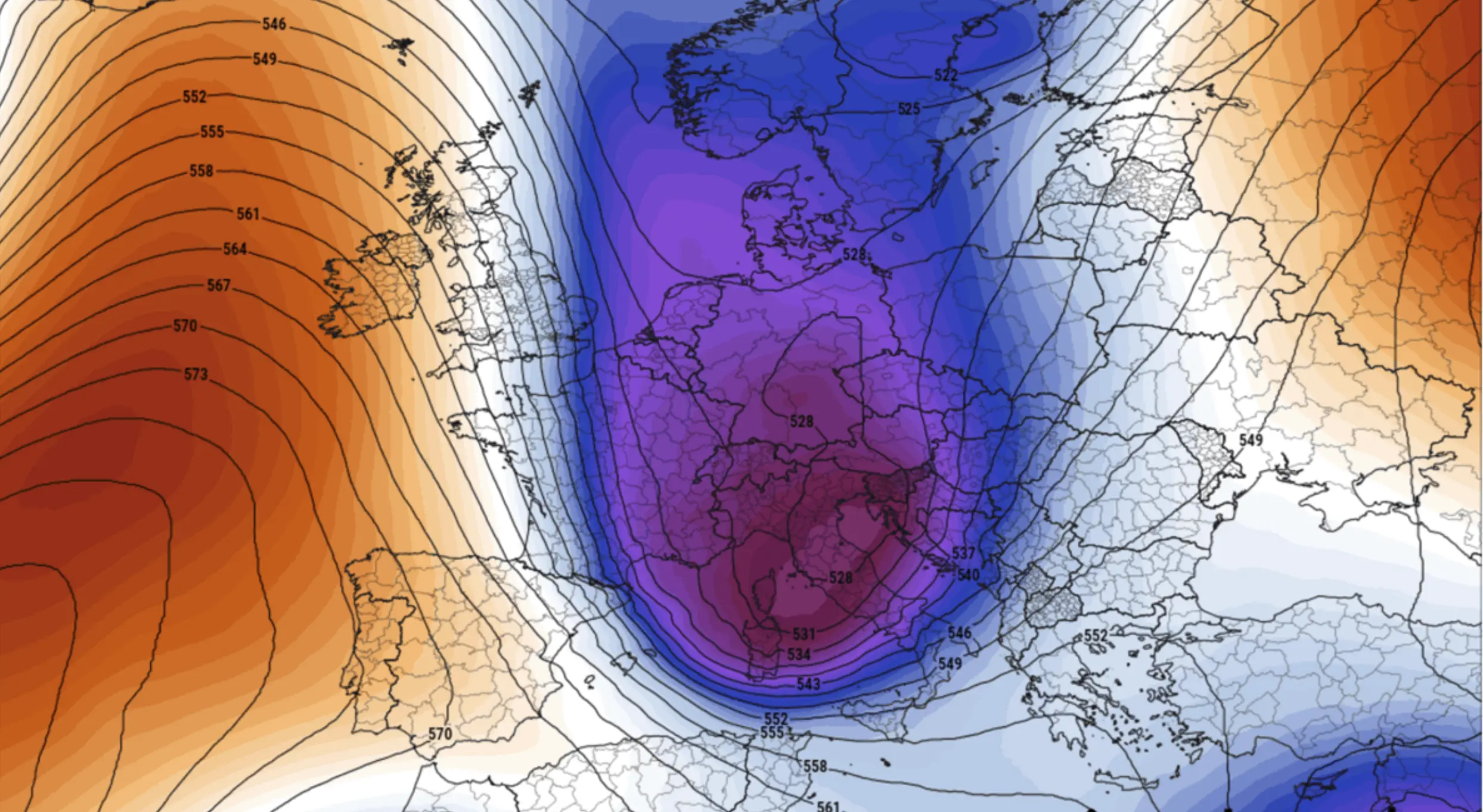
At the turn from March into April, Europe is moving into a classic late-winter setup. A blocking high is strengthening over the North Atlantic and towards Greenland, cutting off the usual supply of milder oceanic air. In response, a corridor opens for Arctic air to plunge southwards — first into Western Europe, then into Central Europe, the Alps, and the Balkans.
The cold air then starts interacting with warmer, moister Mediterranean air. That is what helps produce a secondary cyclone over the northern Mediterranean, bringing snow, sleet, strong winds, and a more sustained winter episode than a brief spring cold front would usually deliver.
When exactly the cold spell begins
23 March 2026
On Monday, 23 March, the main atmospheric pattern starts to shift. Blocking over the Atlantic strengthens, and cold air begins moving south. Not all of Europe will feel the full return of winter on this day, but 23 March is the point at which the whole event is set in motion.
24 March 2026
On Tuesday, 24 March, the frontal system pushes quickly across Western Europe, and temperatures begin to fall sharply. From this point, the spring-like background starts to break down in a number of countries. Conditions turn colder, windier, and wetter, with the first wintry precipitation appearing in some areas.
25 March 2026
On Wednesday, 25 March, the cold reaches the Alps and strengthens over Western Europe. This becomes one of the first truly high-impact days. Across England, northern England, Wales, and Ireland, morning lows may fall to around −2°C, with even lower values in Scotland. By this stage, it becomes clear that this is not just an ordinary front, but a genuine late-season winter relapse.
26–27 March 2026
This is the peak of the entire episode. On Thursday and Friday, a secondary cyclone develops over Italy and the Adriatic, intensifying snowfall across the Alps, Central Europe, and the Balkans. In France and the Benelux countries, morning temperatures may drop to −2 to −6°C. In Germany, Czechia, the Alpine region, and parts of Poland, minima may be even lower, with widespread wintry precipitation.
28–29 March 2026
By the end of the week, the cold will begin to ease only slowly in Western Europe, but frosty mornings will remain a serious threat for vineyards, orchards, and early vegetation. Across the Balkans and the Alps, the cold pool is likely to last longer, with distinctly wintry conditions lingering close to the end of March.
Which countries will be hit hardest
United Kingdom and Ireland
The most unpleasant conditions here are expected on 25 and 26 March. The main issue will not necessarily be heavy snowfall, but the sharp return of sub-zero nights after milder weather. Frost, sleet, slippery roads, and cold winds are all likely.
France, Belgium, the Netherlands, Luxembourg
France and the Benelux countries fall into one of the most vulnerable zones between 26 and 28 March. Morning temperatures may drop to −2 to −6°C in places, which is already dangerous for vineyards, fruit trees, and early spring growth. Eastern France may also see snow or sleet.
Germany, Czechia, Slovakia, Poland
Central Europe is one of the main target zones for this late-winter blow. On 26–27 March, frosty mornings are forecast, in places below −5°C, together with snow and other wintry precipitation. Germany, Czechia, Slovakia, and Poland all sit inside the corridor where late winter could make a particularly forceful return.
The Alps: Austria, Switzerland, northern Italy, southern Germany, eastern France
The Alps are the main snowfall hotspot of the whole event. This is where the heaviest snow is expected. In the mountains, significant fresh accumulations are likely, locally up to 75–100 cm by the end of the episode. That is a full winter storm, with risks of travel disruption, avalanche danger, and difficult conditions on mountain passes.
Italy
Italy plays a key role in the development of the cyclone. In the north of the country and across mountain areas, snowfall risk is high, while in central regions temperatures may locally slip below freezing on Friday and Saturday. For late March, that is already a serious setback.
The Balkans: Slovenia, Croatia, Bosnia and Herzegovina, Serbia, Montenegro
The Balkans are the second major zone of winter’s return after the Alps. Snow and cold may last longest here. With the cyclone in place, blizzard-like conditions, strong winds, and frosty mornings are possible. The western Balkans and northern parts of the region could remain under the influence of this cold spell through Sunday, 29 March, and in some places into early April.
Northern Spain and the Pyrenees
Snow is also likely in the Pyrenees and northern Spain. This is not expected to be the main centre of the cold outbreak, but it will still be a noticeable secondary expression of the wider winter relapse.
Corsica, Sardinia, Sicily
Even the Mediterranean islands will not be completely spared. Parts of Corsica, Sardinia, and Sicily may see unusually low temperatures for late March, with wintry precipitation possible in higher terrain.
Where the heaviest snow is expected
The most intense snowfall is expected in the Alps and the western Balkans. Widespread snow zones are also likely across Germany, Czechia, Slovakia, Poland, eastern France, and northern Italy. Local or more episodic snowfall is possible in the United Kingdom, the Benelux countries, northern Spain, and the Pyrenees.
Why this is especially dangerous right now
The main problem is not only the snow or the drop in temperature itself. This winter relapse arrives after a milder spell, when nature has already started to wake up. That means frosts of −2 to −6°C in late March can be much more damaging than the same cold would have been in February. Vineyards, fruit trees, and early crops are all at risk.
Additional dangers affect transport and logistics. By late March, much of Europe is already mentally and operationally moving out of winter mode. That is exactly why sleet, overnight refreezing, strong winds, and sudden drops in visibility become especially disruptive.
What this means for Europe as a whole
Europe is not heading into a brand-new prolonged winter at the end of March and the start of April 2026, but it is facing a sharp and potentially damaging late-season winter relapse. In the West, it will show up mainly through frost, cold mornings, and local sleet or wet snow. In Central Europe, it will be more clearly expressed through snowfall and stronger cooling. In the Alps and the Balkans, it will feel like a full-scale return of winter storm conditions.
The most difficult part is the timing. The problem is not just the weather itself, but that it arrives after parts of Europe have already begun shifting into a spring rhythm.
Main takeaway
Late March and early April 2026 in Europe look set to bring a sharp late-winter relapse. The most vulnerable countries and regions are the United Kingdom, Ireland, France, Belgium, the Netherlands, Luxembourg, Germany, Czechia, Slovakia, Poland, Austria, Switzerland, northern Italy, Slovenia, Croatia, Bosnia and Herzegovina, Serbia, the western Balkans, northern Spain, and the Pyrenees.
Put very simply: from 25 to 29 March, Europe will feel winter again, and for parts of Central Europe, the Alps, and the Balkans, the effects may stretch into the first days of April.
FAQ: what matters most
When will the cold spell begin in Europe?
The atmospheric shift begins on 23 March, with the sharp turn to colder conditions starting on 24 March.
When is the peak of the winter relapse?
The strongest cooling and snowfall are expected between 25 and 27 March 2026.
Where will the heaviest snow fall?
The largest snowfall totals are expected in the Alps and the western Balkans.
Where will frost be most dangerous?
In France, the Benelux countries, Germany, Czechia, and parts of Central Europe, frost will be especially dangerous for orchards, vineyards, and early vegetation.
Could the cold continue into April?
Yes. In parts of the Balkans and the Alps, the effects of this winter episode may still be felt during the first days of April.
The Founder and Chief Meteorologist at Pogodnik.com. With over 15 years of operational experience in synoptic analysis and climate forecasting, he specializes in storm tracking, magnetic storms, and atmospheric dynamics. A recognized expert in Ukraine’s meteorological sector, he maintains strategic collaborations with global agencies, including NOAA and ECMWF, to ensure high-precision data integration. His analytical reviews and scientific contributions are regularly featured in leading media outlets dedicated to weather science and environmental trends.