Polar Vortex Disruption 2026: Europe’s Arctic Blast Has Arrived — But Is the Worst Still Ahead?
The polar vortex 2026 didn’t just weaken. It shattered — splitting into two fragments and sending the coldest air in years across North America and then straight into the heart of Europe. Late March brought temperature anomalies of −7 to −11°C below normal across France, Germany, and the Alps. And now, another deep polar low is carving through the Mediterranean. The question everyone is asking: is April going to be any different?
POLAR VORTEX 2026 ARCTIC BLAST EUROPE SPRING FORECAST EL NIÑO 2026
How the Polar Vortex 2026 Fell Apart — and Why Europe Got Hit Twice
To understand what is happening right now across Europe — and what is likely coming in April — you need to go back to late November 2025. That is when the first domino fell.
A rare, early-season Sudden Stratospheric Warming (SSW) event hit the polar stratosphere, a full two months ahead of the typical February window. According to Severe Weather Europe’s analysis, this was among the earliest such events on record in the past 70 years. The polar vortex — that enormous spinning wall of cold over the Arctic that keeps frigid air locked away from the mid-latitudes — took a direct hit. It deformed, stretched, and weakened. But it didn’t collapse completely. Not yet.
The second blow came in February 2026. A major SSW event drove temperatures in the stratosphere more than 40°C above normal at the 10 mb level — roughly 30 km above the Earth’s surface. This time, the vortex didn’t just wobble. It split. Two separate vortex fragments went their own ways across the Northern Hemisphere — the most destructive configuration possible, known as a split-type disruption. One lobe drove a historic arctic blast across America in late February and March. The other lobe started rotating toward Europe.
What is a polar vortex split? The stratospheric polar vortex normally sits as a single organized cyclone over the Arctic. When a Sudden Stratospheric Warming event is powerful enough, it can physically break the vortex into two rotating fragments. Each fragment then acts as an independent “cold release valve,” allowing Arctic air to escape into the mid-latitudes. A split-type SSW is the most impactful category — and 2026 produced a textbook example.
The mechanism connecting stratosphere to surface takes three to six weeks. That explains the timing perfectly: the February SSW produced the March cold wave. Severe Weather Europe described the late-March pattern as a “classic late-season Arctic plunge into Europe, driven by the interaction between a displaced polar vortex lobe, a powerful jet stream, and a Blocking High over the Atlantic.” The Atlantic blocking high — a large ridge of high pressure anchored over Greenland and the northeast Atlantic — is the key structural element. It cuts off Europe’s usual supply of mild, westerly air and redirects the polar jet stream southward, directly over the continent.
The Late-March Cold Wave: What the Data Actually Showed
The numbers from the late-March cold weather event across Europe were striking. This was not a borderline cold snap — it was a full-scale polar vortex 2026 Europe impact event, the kind that meteorologists flag as historically significant.
Source: Windy.com surface temperature analysis, 27 March 2026, 05:00 UTC. Anomaly calculated against 1991–2020 WMO climate normals.
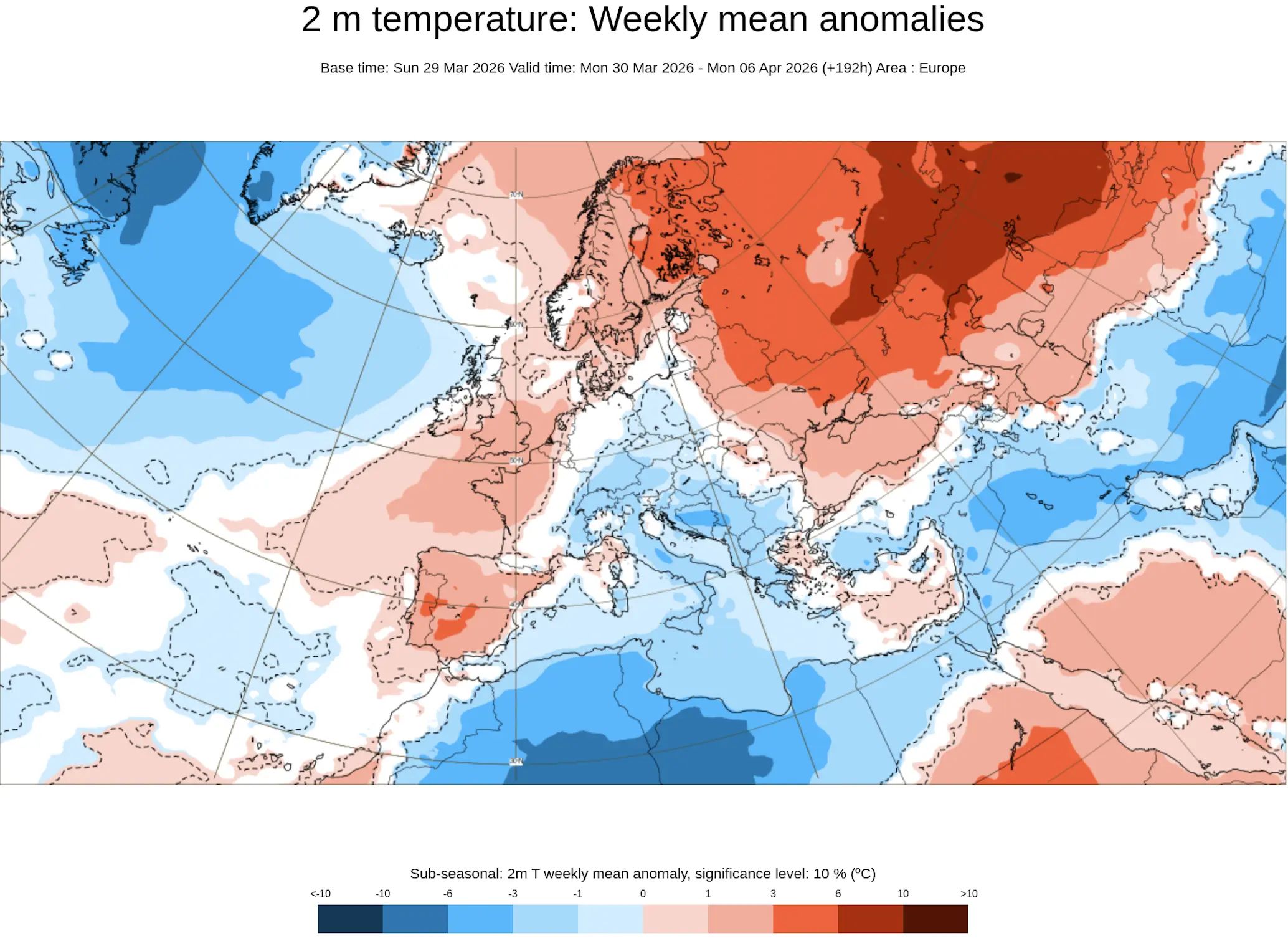
These are not rounding errors or minor deviations. A −12°C anomaly in Innsbruck in late March puts temperatures in the range you’d expect for early January. The 500 hPa geopotential heights over Western Europe — the standard measure of upper-level atmospheric cold — dropped to 522–528 dam, values typical of mid-winter. The sharp temperature drop of 15 to 20°C within just two days across the UK, France, and Germany was described by Severe Weather Europe as the defining characteristic of the event: not a gradual cooling, but a sudden, violent reversal of what had been an unusually warm early spring.
The Mediterranean Is Next: A Deep Polar Punch Into Greece and the Aegean
Just as Western and Central Europe begin to register a slight recovery from the late-March deep freeze, the same blocking pattern is generating a second, more southern impact. A powerful upper-level cold wave — described by Severe Weather Europe’s Marko Korošec as “the final kick of the polar vortex collapse” — is carving a path southward through the atmosphere toward the warmer waters of the Ionian and Aegean Seas.
By Wednesday (April 1–2), this upper-level wave cuts off from the main flow and becomes a cut-off low over the southern Mediterranean. The warm sea surface below provides heat and moisture. The polar-origin air aloft provides violent instability. The result is a pattern that meteorologists classify as baroclinic instability — and it acts as an engine for rapid, explosive cyclogenesis.
⛈ Greece & Aegean: Active Severe Weather Threat (April 1–3, 2026)
Torrential rain and thunderstorms — rainfall totals locally exceeding 100 mm in 24 hours over south and central Greece
Flash flood risk — particularly in mountainous terrain and urban areas of Athens, Thessaloniki, and the Peloponnese
Dangerous Aegean winds — gale-force gusts locally reaching 9–10 Beaufort; wave heights up to 7 metres
Severe thunderstorms and tornado risk — rotating supercells not excluded over the Aegean, particularly in the Crete–Rhodes–Izmir corridor
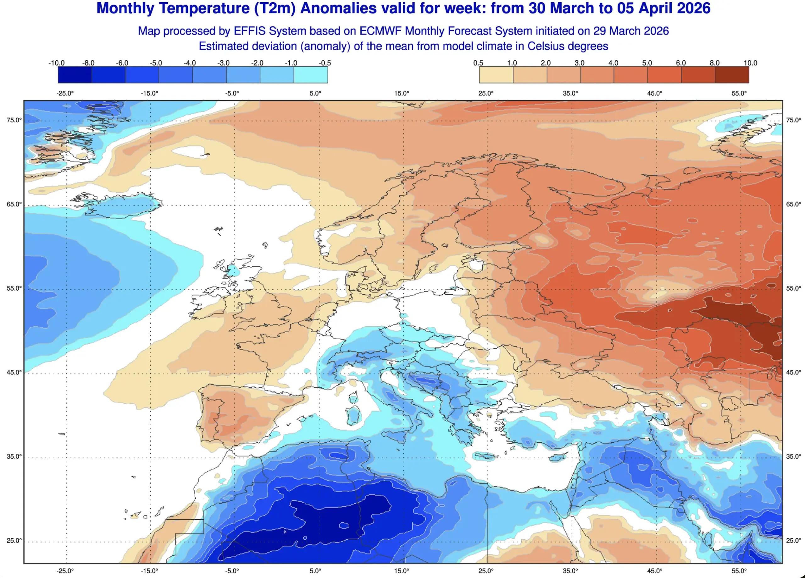
Temperature anomaly — up to 15°C below normal for early April across Algeria, Tunisia, Libya, and the southern Mediterranean basin
This is the same blocking signature at work: the massive high-pressure ridge over the North Atlantic and Western Europe is not just forcing cold air into France and Germany. On its eastern flank, the deep trough digging south across Scandinavia and Central Europe toward the Mediterranean generates a powerful jet stream in between. That jet delivers unseasonably cold, polar-origin air deep into the Mediterranean basin — far further south than any model would project during a normal spring.
Weather Forecast Europe April 2026: Will the Polar Vortex Strike Again?
This is the question that matters most for the Europe spring weather forecast 2026: once this current wave passes, does Europe get a genuine window of seasonal weather — or does the vortex remnant take another shot?
The honest answer, based on the current model consensus and the state of the stratosphere, is: probably both. April 2026 is forecast to open with a continuation of the volatile, blocked pattern — and then gradually transition toward more seasonal conditions in the second half of the month as the stratospheric signal exhausts itself.
Here’s why. The stratospheric polar vortex itself has effectively dissolved for the season — this is normal by spring. But its legacy persists in the troposphere. The Greenland blocking high, which was set in motion by the vortex disruption, tends to be self-reinforcing for several weeks. It reshapes the planetary wave structure in ways that keep the North Atlantic flow split and the door to cold air partially open. After the February 2021 SSW, for example, Europe saw cold intrusions well into April. The 2018 “Beast from the East” had a similar origin story.
Period
Pattern
Cold Risk for Europe
Confidence
Mar 31 – Apr 3
Greenland block active; deep cut-off low → Mediterranean
HIGH — ongoing
✅ High
Apr 4 – 10
Block persists; new trough possible into W. Europe
MODERATE — 30–40%
⚠️ Medium
Apr 11 – 17
Block begins eroding; Atlantic ridge building slowly
LOW-MODERATE
⚠️ Medium-Low
Apr 18 – 30
El Niño signal asserts; zonal flow restoring
LOW — spring establishing
✅ Medium-High
⚠️ Polar vortex April 2026 — key risk window: ECMWF ensemble members consistently flag a 500 hPa height anomaly 60–150m below normal over parts of Western Europe in the April 4–10 window. This is the signature of a significant cold intrusion. While the ensemble mean is less alarming, the spread is large enough — and the historical analog (post-SSW April cold events in 2009, 2018, 2021) strong enough — to treat this window as a genuine cold risk, not a statistical footnote.
Which European Regions Are Most Vulnerable in April 2026?
Not all of Europe faces the same risk. Geography, elevation, and proximity to the blocking pattern’s eastern flank all determine who takes the brunt. Here is how the risk breaks down by region for the weather forecast Europe April 2026:
🇫🇷 France / 🇧🇪 Benelux / 🇩🇪 Germany — HIGHEST RISK. These regions sit directly under the eastern flank of the Greenland block, where deep cold troughs arrive first and most intensely. Winegrowing regions in Champagne, Burgundy, and the Rhine Valley face frost risk through at least mid-April. Temperature anomalies of −5 to −8°C below normal remain possible in cold outbreak episodes during the first two weeks.
🇨🇭 Switzerland / 🇦🇹 Austria / 🇸🇮 Slovenia — HIGH RISK (amplified by Alpine topography). Cold air pools in Alpine valleys more efficiently than in lowland areas, producing the most extreme temperature anomalies seen in the late-March event. Even when surface temperatures recover slightly on the plains, the Alps keep generating their own cold pools.
🇬🇧 United Kingdom / 🇮🇪 Ireland — MODERATE-HIGH RISK. The UK sits at the leading edge of every cold intrusion arriving from the northwest. Strong northerly or northwesterly flows bring snow showers to Scotland and northern England and freezing nights to most of the country. The northwest coast is simultaneously a pathway for mild Atlantic breaks — so the pattern here is more volatile than further east.
🇵🇱 Poland / 🇨🇿 Czech Republic / 🇸🇰 Slovakia — MODERATE RISK (with a late onset). Eastern Central Europe receives cold intrusions slightly later than the western flank, but once established, cold air can get trapped under anticyclonic conditions and persist longer. The April 4–10 window is the main concern here.
🇬🇷 Greece / 🇮🇹 southern Italy / 🇹🇷 western Turkey — DIFFERENT RISK TYPE. These regions are not primarily threatened by persistent surface cold — they are threatened by the deep cut-off lows that the blocking pattern generates. Severe thunderstorms, torrential rain, dangerous winds, and flash flooding are the primary hazards here, not sustained frost.
🇪🇸 Spain / 🇵🇹 Portugal — LOW-MODERATE RISK. The Iberian Peninsula is partially shielded by its southwesterly position. Mountain snowfall is possible in the Pyrenees and Sierra Nevada, and some below-normal temperatures in the north, but severe surface cold at lowland elevations is less likely than further northeast.
🇺🇦 Ukraine / 🇧🇾 Belarus / Eastern Europe — LOW RISK. Eastern Europe remains in a warm anomaly zone during this episode — the same dipole pattern that drives cold into the west drives warm air advection from the south and southeast into the east. Kyiv, Minsk, Warsaw, and Bucharest are likely to see above-normal temperatures throughout most of this period.
El Niño Is Building Fast — And That Changes the April 2026 Outlook Gradually
Here is where the polar vortex 2026 story intersects with the bigger picture of what is happening in the tropical Pacific — and why April is likely to be the last difficult month before the atmosphere truly resets.
La Niña has dissolved. Severe Weather Europe’s March 27 summer forecast update confirmed what ocean data has been screaming for weeks: a massive subsurface warm Kelvin wave has swept from west to east across the equatorial Pacific, erasing the remnant La Niña cold pool and pushing sea-surface temperatures well into positive territory. The NMME and international multi-model forecasts now agree — El Niño is emerging, with some models projecting a Super El Niño developing by late 2026 or into 2026/2027.
🌊 ENSO Transition — What It Means for Europe
Mar–Apr 2026
La Niña
Fading · Europe still cold-vulnerable
May–Jul 2026
Neutral
Block eroding · Spring normalizing
Jun–Aug 2026
El Niño
62% probability · Summer warming
For Europe, the relevance of this ENSO shift is gradual rather than immediate. El Niño doesn’t flip a switch and end cold weather overnight. But it does shift the background atmospheric circulation in ways that make persistent Greenland blocking progressively less likely as spring advances. The Azores High strengthens, the westerly Atlantic flow reasserts, and the jet stream tends to track in a more zonal (east–west) path rather than the amplified meridional (north–south) waves that have been sending Arctic air deep into the continent.
The practical takeaway: April 4–10 is the last credible window for a significant cold outbreak in Western and Central Europe. After that, the probability drops significantly. The second half of April should see temperatures trending toward or above seasonal norms across most of the continent.
Historical Context: The Three Best Analogs for What Europe Is Experiencing
This is not the first time a major SSW event and polar vortex split have produced a late-season European cold wave. Forecasters lean on historical analogs to calibrate how long these patterns persist and how intense they get. The three closest analogs to the 2026 polar vortex disruption episode are:
February–March 2018 (“Beast from the East”). A powerful SSW in January 2018 split the vortex and produced the most severe late-winter cold snap in the UK and Western Europe in nearly three decades. February and March 2018 brought blizzard conditions to Britain, −10°C in Paris, and record late-March snowfall across Central Europe. Cold outbreaks persisted intermittently through most of April before the pattern finally broke.
January–April 2021. A major SSW in January 2021 produced cold waves that kept arriving through April. France suffered devastating late-frost events on April 7–8, 2021, destroying an estimated 80% of some vineyard harvests. The persistent blocking pattern extended cold intrusion risk well beyond what most seasonal outlooks had anticipated.
February–March 2009. An SSW event led to cold outbreaks in the UK, France, and Germany through March, followed by a volatile April before a warm May. The analogy is less extreme than 2018 or 2021 — and the 2026 scenario may land somewhere between the two in terms of severity.
🌱 Agricultural note for Western and Central Europe: The 2021 analogy is the most directly cautionary one for growers. Vineyards in Champagne, Burgundy, Bordeaux, the Rhine Valley, and northern Italy that already woke up under the warm early-March temperatures are now at serious risk of late-frost damage. The April 4–10 cold window deserves attention from any farmer or grower with active early-season vegetation. Active frost protection measures are warranted.
📊 Bottom Line: Polar Vortex 2026 Europe — What to Expect in April
The polar vortex disruption 2026 has been one of the most consequential late-winter atmospheric events in recent memory. Two SSW events, a split-type vortex collapse, an arctic blast across America in February–March, and then a delayed, powerful cold wave into Europe in late March — the sequence was textbook.
For polar vortex April 2026 Europe, the risk is not zero — and pretending otherwise would be misleading. The Greenland blocking high is still active. Another cold intrusion into Western and Central Europe in the April 4–10 window carries a 30–40% probability based on ECMWF ensemble guidance. The Mediterranean faces its own separate threat from deep cut-off lows through early April.
After mid-April, the probability of further significant cold outbreaks drops sharply as La Niña fully dissolves and El Niño begins to assert its influence on the large-scale circulation. Spring should finally arrive — for real — in the third week of April. But for now, winter is not done making its case.
Frequently Asked Questions
Is the polar vortex disruption 2026 finally over for Europe?
Not entirely. The stratospheric vortex has dissolved for the season, but its legacy — the Greenland blocking high — keeps the cold air door partially open for Western and Central Europe through early to mid-April. The April 4–10 window carries a 30–40% probability of another significant cold episode based on ECMWF ensemble guidance.
Which European regions are most at risk of cold weather in April 2026?
Western France, Benelux, Germany, Switzerland, and Austria carry the highest risk of surface cold in early April. Greece and the Aegean face a different threat — severe weather from deep Mediterranean cut-off lows. Eastern Europe (Ukraine, Belarus, Poland east) remains in a warmer zone for most of this period.
What caused the polar vortex 2026 to collapse so severely?
Two Sudden Stratospheric Warming events — an unusually early one in late November 2025 and a final, major one in February 2026 — combined to split the polar vortex into two fragments. This split-type disruption is the most impactful category and, historically, produces the most persistent downstream cold weather impacts for both North America and Europe.
How does the arctic blast in America relate to the cold wave in Europe?
Both events trace back to the same polar vortex split. One lobe drove the arctic blast across America in February–March; the second lobe shifted toward the European side of the Northern Hemisphere with a 3–4 week delay. It’s a classic “sequential delivery” pattern from a split-type SSW — North America gets hit first, Europe follows.
How does El Niño change the spring 2026 outlook for Europe?
As El Niño establishes in the Pacific through spring and summer 2026, it gradually shifts the large-scale atmospheric circulation toward a more zonal (east–west) jet stream pattern. This weakens Greenland blocking episodes and makes persistent cold intrusions into Western Europe progressively less likely. The main effect should be felt from mid-to-late April onward, with spring fully establishing before the end of the month.
The Founder and Chief Meteorologist at Pogodnik.com. With over 15 years of operational experience in synoptic analysis and climate forecasting, he specializes in storm tracking, magnetic storms, and atmospheric dynamics. A recognized expert in Ukraine’s meteorological sector, he maintains strategic collaborations with global agencies, including NOAA and ECMWF, to ensure high-precision data integration. His analytical reviews and scientific contributions are regularly featured in leading media outlets dedicated to weather science and environmental trends.