US Heat Wave 2026: Historic Heat Dome Hits 200+ Million Americans Before Fourth of July
A historic heat dome is locking a huge part of the United States under dangerous heat just as millions prepare for Fourth of July travel, outdoor events and holiday gatherings. The worst conditions stretch from the central U.S. and Midwest toward the Great Lakes, the I‑95 corridor, the Southeast and the East Coast, where humidity is pushing heat index values into the 105–115°F range.
Main threat: this is not just hot summer weather. A blocking high-pressure ridge is trapping heat and moisture over more than two-thirds of the contiguous United States, creating dangerous heat stress for more than 200 million people.
Peak window: the most dangerous holiday-period heat is expected from Thursday through the Fourth of July weekend, with the heat dome likely lingering into the early part of next week in parts of the central and eastern U.S.
Long-range signal: NOAA CPC shows renewed extreme heat risk for July 9–15 from the Southwest and Great Basin into the Rockies, Great Plains and Upper Midwest, plus a separate heat risk for the eastern Gulf Coast and Florida Peninsula.

Why This Heat Wave Is So Dangerous
The United States is entering a high-impact heat event at one of the worst possible times: the Fourth of July holiday period. Millions of people will be outside for parades, concerts, fireworks, baseball games, barbecues, beach trips, travel delays and major public gatherings. At the same time, the atmosphere is placing a “lid” over much of the country.
A heat dome forms when a large ridge of high pressure traps hot air beneath it. Air sinks, compresses, dries out and heats further near the surface. Clouds and storms are suppressed in many areas, sunshine becomes relentless, humidity builds in the lower atmosphere, and overnight temperatures stay too warm for the body to recover.
This heat wave is especially dangerous because humidity is high. In many areas, the thermometer may show the upper 90s or low 100s Fahrenheit, but the human body may experience the heat as 105–115°F because sweat cannot evaporate efficiently. That is when heat exhaustion and heat stroke can develop quickly, especially for outdoor workers, children, older adults, athletes, travelers and people without reliable cooling.
What Is Driving the Historic Heat Dome?
The current setup features a strong upper-level ridge and broad high pressure over the central and eastern United States. To the west, a deeper upper wave is moving into the Pacific Northwest and western states, while downstream ridging builds over the central and eastern U.S. This pattern helps lock hot and humid air over the most populated corridors of the country.
The hottest and most humid air mass first expands across the central U.S., the Midwest, the Great Lakes, the Northeast and eastern Canada. At roughly 850 mb, temperatures may run around 10–15°C above normal across parts of the Great Lakes, Northeast and Ontario. At the surface, that translates into highs in the mid-90s to near 100°F across many cities and heat index values above 110°F in the most humid areas.
The I‑95 corridor is one of the most exposed zones. New York City, Philadelphia, Washington, D.C. and surrounding suburbs face dangerous heat compounded by concrete, asphalt, dense buildings, traffic and hot nights. Midwest hubs such as Chicago, Detroit and St. Louis also remain in the dangerous heat corridor.

Fourth of July Heat Timeline
July 2–3
Heat Builds Fast
Heat intensifies across the central and eastern U.S. as the ridge strengthens. Many areas push into the 90s, while high humidity drives heat index values above 100°F.
July 4 Weekend
Peak Holiday Danger
The Fourth of July weekend brings the biggest public-exposure risk. Outdoor gatherings, travel, fireworks and sporting events coincide with dangerous heat index values in many metro areas.
July 7–15
Heat Risk Reloads
Long-range guidance points to a rebuilding ridge and renewed heat risk from the Southwest and Great Basin into the Rockies, Great Plains and Upper Midwest, plus Florida and the eastern Gulf Coast.
Region-by-Region Forecast: Where the Heat Hits Hardest
The table below summarizes the main heat zones for the first half of July. Local National Weather Service offices should be checked for official watches, warnings and advisories, but the broad pattern is clear: intense holiday heat in the central and eastern U.S., followed by renewed risk shifting west and north-central during week two.
| Region | Fourth of July Weekend | July 7–11 | July 9–15 Long-Range Signal | Main Risk |
|---|---|---|---|---|
| I‑95 Corridor: NYC, Philadelphia, Washington, D.C., Baltimore, Boston | Dangerous heat and humidity. Highs in the upper 90s to near 100°F are possible in many urban areas, with heat index values much higher. | Some moderation may arrive, but humid heat can linger, especially in cities and coastal plains. | Heat risk may ease compared with the holiday peak, but warm nights and humidity remain important. | Urban heat stress |
| Midwest and Great Lakes: Chicago, Detroit, St. Louis, Indianapolis, Cleveland | Very hot and humid. Thunderstorms may interrupt heat locally, but the overall heat index remains dangerous. | Pattern becomes more variable, with storm chances and possible heat breaks. | Upper Midwest may re-enter heat risk if the ridge rebuilds toward the north-central U.S. | Heat plus storms |
| Southeast: Atlanta, Nashville, Charlotte, Raleigh, Birmingham | High humidity creates oppressive apparent temperatures. Heat index values over 105°F are possible in many locations. | Heat remains a concern, but storms may bring localized relief and localized flooding risks. | Above-normal temperatures remain favored along parts of the Southeast and Mid-Atlantic coasts. | Humid heat |
| Florida and Eastern Gulf Coast | Hot, humid and oppressive, especially away from immediate sea-breeze relief. | Heat index values remain dangerous during afternoon hours. | NOAA CPC highlights a slight risk of extreme heat for the eastern Gulf Coast and Florida Peninsula through July 9–15. | Persistent heat risk |
| Texas and Southern Plains | Very hot. High cooling demand and warm nights remain major problems. | Heat remains favored, especially where dry soils and strong sunshine persist. | NOAA’s July outlook increases above-normal temperature probabilities over parts of Texas, reaching 60–70% in some areas. | Long-duration heat |
| Southwest: Arizona, New Mexico, Nevada, Southern California deserts | Hot desert conditions continue, with very high afternoon temperatures. | Heat risk rebuilds as the ridge shifts or reamplifies westward. | NOAA CPC highlights extreme heat risk across the Southwest and Great Basin during July 9–15. | Extreme heat reload |
| Great Basin, Rockies, Northern Intermountain West | Not the first core of the holiday heat dome, but hot and dry conditions increase risk. | Heat begins to rebuild as mid-level high pressure redevelops. | NOAA CPC indicates slight risk of extreme heat from the Great Basin and Rockies into the Great Plains during July 9–15. | Week‑2 heat risk |
| Pacific Northwest and California | More influence from the western upper trough, but dry winds and fire weather can still be a concern. | Pressure gradients may strengthen along the West Coast. | NOAA CPC highlights episodic high-wind risk for parts of California and the Pacific Northwest during July 9–15. | Wind and fire concern |
Heat Index: Why 100°F Can Feel Like 115°F
The heat index combines air temperature and humidity to estimate how hot conditions feel to the human body. When humidity is high, sweat evaporates more slowly. That weakens the body’s natural cooling system. A temperature near 95–100°F can therefore feel closer to 105–115°F when the air is humid and stagnant.
This is why the eastern two-thirds of the U.S. are under such serious concern. The combination of high temperatures, Gulf and Atlantic moisture, weak overnight cooling and dense urban surfaces creates a dangerous feedback loop. The body loses water and salt faster, the heart works harder, and heat illness risk rises even for healthy people.

Do not judge danger by the thermometer alone
A humid 96°F afternoon can be more dangerous than a dry 102°F afternoon. Always check heat index, HeatRisk, local warnings and overnight lows before planning outdoor work, sports, travel or holiday events.

Hot Nights Are the Hidden Emergency
The heat dome is not only creating dangerous afternoons. It is also trapping warmth overnight. In major urban corridors, overnight lows may fail to drop below 75°F or even 80°F. That removes the recovery window the body normally needs after daytime heat exposure.
This is especially dangerous for people without air conditioning, older adults living alone, infants, outdoor workers staying in poorly cooled housing, people with heart or lung disease, and anyone taking medications that affect hydration or temperature regulation.
A single hot day is stressful. Several hot days followed by hot nights can become a public-health emergency. Emergency rooms, cooling centers, power grids and public transit systems can all face stress at the same time.
Long-Range Forecast: What Happens After the Fourth of July?
NOAA’s 6–10 day outlook is valid for July 7–11, and the 8–14 day outlook is valid for July 9–15. The key message is that the holiday heat dome may not simply disappear. The pattern shifts, but heat risk remains in the forecast.
The CPC hazards outlook for July 9–15 highlights a slight risk of extreme heat across much of the Great Basin, Northern Intermountain region, Rockies, Southwest and Great Plains. It also keeps a separate extreme heat risk for the eastern Gulf Coast and Florida Peninsula. At the same time, parts of the Mid‑Atlantic and Southeast carry a heavy-precipitation risk, meaning the next pattern may combine heat, humidity, storms and flooding.
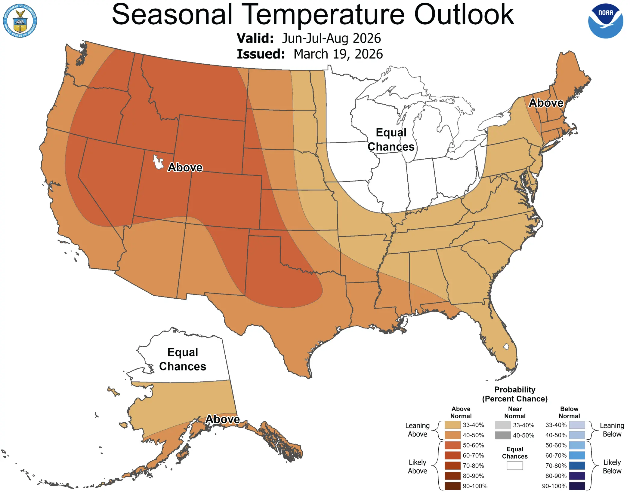
NOAA’s July monthly outlook favors above-normal temperatures across the western third of the contiguous U.S., the southern tier and much of the East Coast into New England. Above-normal temperature probabilities are especially enhanced over parts of Texas, where some areas reach 60–70% chances of a warmer-than-normal July. The outlook also notes uncertainty across the Northern Plains, Upper Midwest, Great Lakes and Ohio Valley, where model differences and pattern shifts reduce confidence.
The CFSv2 seasonal and monthly guidance is a model tool, not the official forecast by itself, but it supports the idea that the broader summer pattern remains warm-biased in key regions. For practical planning, this means the first heat dome is not the end of the story. July can produce several pulses: an eastern holiday heat wave first, then a western or central U.S. heat reload later.
Why Power Grids and Infrastructure Are Under Pressure
Extreme heat affects more than health. It pushes power demand higher as homes, offices, stores, hospitals and data centers run cooling systems for long hours. When nighttime temperatures remain high, air conditioning does not get a break. That keeps electricity demand elevated overnight and can stress the grid during the next afternoon peak.
Roads, rails and airports are also affected. Asphalt softens, rail tracks expand, and very hot air can reduce aircraft performance during takeoff. Public transportation can slow down exactly when people need cooling centers, shade and safe mobility.
The same heat also increases stress on livestock, wildlife and crops. Warm nights reduce recovery for animals as well as people. High humidity makes cooling harder. Drought-stressed vegetation can worsen wildfire danger across the West and parts of the Plains.
Fourth of July Events: What Organizers and Families Should Do
- Move events earlier or later. The hottest part of the day is usually mid-afternoon into early evening, especially in urban areas.
- Build a cooling plan. Know where the nearest air-conditioned building, cooling center, shaded park shelter or public library is located.
- Do not rely on water alone. Shade, rest, loose clothing, cooling breaks and reduced activity are also necessary.
- Check on older adults. A phone call is not always enough. People may not realize how hot their apartment has become.
- Protect pets. Pavement can burn paws, and pets can overheat quickly in parked cars or crowded outdoor events.
- Watch storms after peak heat. Some regions may see severe thunderstorms on the edge of the heat dome, especially from the northern Plains into the Midwest and Great Lakes.
Heat Illness: Warning Signs to Know
Heat exhaustion can begin with headache, dizziness, weakness, nausea, heavy sweating, thirst, irritability and elevated body temperature. If symptoms worsen, vomiting develops, confusion appears or the person stops sweating and becomes hot to the touch, heat stroke becomes a medical emergency.
Move the person to a cooler place, loosen clothing, apply cool wet cloths, offer small sips of water if they are awake and not vomiting, and seek medical help if symptoms persist or worsen. Heat stroke requires immediate emergency care.
Track Heat, Humidity and Local Storms in the Pogodnik App
During a heat dome, a simple temperature number is not enough. Check hourly temperature, humidity, storms, wind, air quality, fire risk and local alerts before travel, outdoor work or Fourth of July events. Pogodnik helps you follow the weather for your location and see when dangerous heat may ease.
FAQ
How many Americans are affected by the July 2026 heat dome?
More than 200 million Americans are exposed to dangerous heat conditions from this heat dome, with more than 230 million likely to experience daytime highs above 90°F during the event.
Where is the heat wave most dangerous?
The highest near-term risk stretches from the central U.S. and Midwest into the Great Lakes, Northeast, Southeast and I‑95 corridor. The long-range risk later shifts toward the Southwest, Great Basin, Rockies, Great Plains, Florida and the eastern Gulf Coast.
What is the heat index expected to reach?
In the most humid parts of the heat dome, heat index values may exceed 105°F and locally approach or surpass 110°F. Some forecasts and reports indicate peak apparent temperatures up to around 115°F in the worst areas.
Will the heat wave end after the Fourth of July?
Not everywhere. The first holiday heat dome may weaken or shift in some regions, but NOAA CPC long-range guidance indicates renewed extreme heat risk during July 9–15 across parts of the Southwest, Great Basin, Rockies, Great Plains, Florida and the eastern Gulf Coast.
Why are hot nights dangerous?
Hot nights prevent the body from recovering after daytime heat. When overnight lows stay near or above 75–80°F in cities, heat stress accumulates and the next day begins with the body already under strain.
What should people do during the heat dome?
Limit outdoor activity, avoid the hottest part of the day, drink water regularly, seek air-conditioned spaces, check on vulnerable people, never leave children or pets in cars, and follow local NWS watches, warnings and HeatRisk guidance.
Sources
This article is based on Severe Weather Europe’s analysis of the historic U.S. heat dome, NOAA Climate Prediction Center 6–10 day and 8–14 day outlooks, CPC week‑2 hazards, NOAA/NWS HeatRisk guidance, CDC and NWS heat safety guidance, and current reporting from AP, Reuters and The Guardian.
NOAA CPC — Monthly Outlook Discussion,
NWS HeatRisk