Polar Vortex Collapse Brace for Wild Weather in the U.S. and Canada in 2025
The polar vortex collapse in early 2025 has already shaken up weather patterns, and its effects are set to linger through May, with new twists forecast for the U.S. and Canada as summer approaches. Triggered by a powerful Sudden Stratospheric Warming (SSW) event in March, this atmospheric upheaval is driving chilly snaps, warm spells, and unpredictable storms. Here’s what’s happening, why it matters, and how it could impact your spring and early summer plans in 2025.
What’s the Polar vortex collapse, and Why Should You Care?
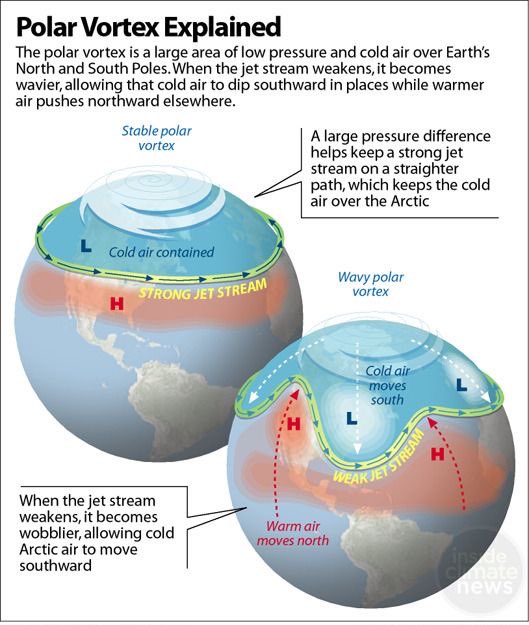
Picture the polar vortex as a massive, spinning shield of frigid air circling the North Pole. It stretches high into the atmosphere, from the troposphere (where our weather happens) to the stratosphere (a drier, higher layer). When it’s strong, it locks Arctic cold in the polar regions, keeping places like the U.S. and Canada relatively mild during winter and early spring. But when it weakens or collapses—watch out! That icy air can spill southward, bringing Arctic chills, snow, and stormy weather to places unaccustomed to such conditions.
In March 2025, a dramatic stratospheric warming event caused the polar vortex to split apart, setting the stage for months of unusual weather across North America. This polar vortex collapse is no small matter—it’s already reshaped spring and is poised to influence early summer. Let’s dive into how it works and what you can expect. (Explanation)
Take a look at what a polar vortex is and why it causes such bitter cold temperatures. pic.twitter.com/pKUhTThzyS
The Science Behind the Chaos: Stratospheric Warming
The key player in this drama is Sudden Stratospheric Warming (SSW). This happens when temperatures in the stratosphere—10 to 50 km above Earth—spike rapidly, sometimes by 20–40°C in just days. These heat surges, often triggered by waves of energy rising from the troposphere, disrupt the polar vortex’s steady spin. In March 2025, an unusually intense SSW event shattered the vortex into two cores, as seen in mid-stratospheric analyses at 31 km (18.5 miles). The result? A deformed vortex, with a high-pressure “void” that’s been stirring up trouble ever since.
This stratospheric chaos doesn’t stay up high—it crashes down to the surface. High-pressure anomalies from the stratosphere slowly descend, altering the jet stream and triggering weather anomalies like cold fronts, warm surges, and storms. Forecasts show this influence peaking in mid-May before fading, but not before leaving a mark on North American weather.
Key Terms to Know
Polar Vortex Collapse: When the vortex weakens or splits, releasing cold air southward.
Sudden Stratospheric Warming (SSW): A rapid stratospheric temperature spike that disrupts the vortex.
Pressure Anomaly: Abnormal high or low pressure that shifts weather patterns.
Temperature Anomaly: Unusual warm or cool conditions compared to normal.
How the Polar Vortex Collapse Is Shaping Spring 2025
The stratospheric warming 2025 event has already made spring a rollercoaster. Since March, high-pressure anomalies have been sinking from the stratosphere, influencing weather across the U.S. and Canada. Here’s how it’s playing out and what’s coming next.
Early May: A Tale of Two Climates
In early May, the lingering effects of the polar vortex collapse are creating a stark contrast across North America:
Unseasonable Warmth: A high-pressure ridge over the northern U.S. and southern Canada is bringing balmy temperatures, with highs soaring into the mid-80s to low 90s in the northern Plains and upper Midwest—way above normal for May!
Chilly South and East: Meanwhile, low-pressure systems are ushering in cooler-than-normal air over the southern and eastern U.S., with temperatures dipping into the mid-60s along the East Coast. The Northwest, including northern California, is also feeling a cool bite, with highs in the high 30s to low 40s.
Rainy Southeast: Expect wet weather in the southeastern and eastern U.S., as low-pressure systems fuel heavy rainfall. The central and northern U.S., however, will stay drier under high-pressure influence.
Mid-May: A New Cold Wave
By mid-May, the final wave of stratospheric influence will hit, bringing fresh changes:
High-Pressure Shift: A strong high-pressure system over the North Atlantic and Greenland will nudge a ridge into western North America, while a low-pressure area over the continent pulls colder air south.
Cooling Trend: A chilly airmass will spill from western Canada into the northern and western U.S., dropping morning temperatures to the low 40s or even mid-30s in the upper Midwest and western states. The central and eastern U.S. will hold onto above-normal warmth for now.
Rain on the Way: Rainfall will ramp up across the northern and north-central U.S. and south-central Canada, tied to a cold front sweeping in from the north.
Late May: Winter’s Last Gasp?
As May wraps up, the polar vortex collapse could deliver a final surprise:
Cooler East: A highCreative Assistant: h-pressure system over eastern Canada will strengthen, driving a cooler airmass across western and southern Canada into the northern and eastern U.S. Ensemble forecasts suggest unseasonably cold temperatures, with single-run models hinting at morning lows in the 30s and 40s in parts of the eastern U.S.
Widespread Rain: Increased precipitation is expected over the northern and eastern U.S., linked to low-pressure systems and the advancing cool airmass. This pattern echoes the typical 0-60 day temperature anomalies following an SSW event, signaling the last hurrah of the stratospheric warming’s influence.
What’s in Store for Early Summer 2025?
As the stratospheric warming 2025 effects fade in late May, new weather patterns are gearing up for the meteorological summer (June, July, August). Extended-range forecasts offer a glimpse into June 2025:
Late May to Early June
Eastern Cool, Southern Heat: The ECMWF model predicts below-normal temperatures persisting in the eastern U.S., paired with increased rainfall for an unsettled end to spring. The southern U.S. and Plains will see above-normal temperatures, while western Canada and the northwestern U.S. stay cooler.
Dynamic Transition: This mix of cool, wet conditions in the east and warm, stable weather in the south sets the stage for a varied start to summer.
June 2025 Outlook
Western Heatwave: A high-pressure ridge over the western U.S. will bring stable, hot conditions to the western and central U.S. and southwestern Canada, with temperatures climbing well above average.
Milder East: A low-pressure trend in the eastern U.S. and southeastern Canada will keep temperatures milder, with a higher chance of rainfall and unsettled weather. The U.S. NCEP’s CFSv2 model aligns with this, forecasting a tame early summer in the east.
Regional Divide: Expect a split summer vibe—scorching and sunny in the west, cooler and stormier in the east.
These trends suggest a dynamic summer kickoff, with regional differences driven by the lingering atmospheric shifts from the polar vortex collapse.
Why This Matters: Impacts on Life and Economy
The polar vortex collapse isn’t just a weather nerd’s fascination—it hits where it hurts: your daily life and wallet. Here’s what’s at stake in spring and early summer 2025:
Agriculture: Late cold snaps or snow could damage early crops or delay planting, especially in the central and eastern U.S., threatening farmers’ livelihoods.
Travel Disruptions: Snow, ice, or storms may snarl roads, delay flights, and disrupt supply chains, particularly in the eastern U.S. and Canada.
Energy Costs: Colder temperatures will spike heating demand, potentially straining power grids and hiking utility bills, while hot western summers could drive up cooling costs.
Health and Safety: Extreme weather swings—chilly mornings to scorching afternoons—pose risks, especially for vulnerable populations.
Lessons from Past Polar Vortex Collapses
History shows the polar vortex can pack a punch. In January 2014, a collapsed vortex plunged the U.S. into a deep freeze, with temperatures dropping to -40°C in some areas and heavy snow paralyzing cities like Chicago and New York. In February 2021, a similar event crippled Texas’s power grid, leaving millions without heat. These events remind us that a polar vortex collapse can disrupt lives and economies on a massive scale.
How to Prepare for Spring and Summer 2025
Don’t let the polar vortex collapse catch you off guard. Here’s how to stay ahead:
Stay Informed: Monitor local weather forecasts for updates on cold fronts, storms, or heatwaves.
Prepare for Cold: Stock up on warm clothing, blankets, and emergency supplies, especially in the eastern U.S. and Canada, where late chills are likely.
Plan for Heat: In the western U.S., ensure air conditioning is ready and stay hydrated during early summer heatwaves.
Protect Crops: Farmers should consider frost protection measures for early spring planting.
Conserve Energy: Insulate homes and use energy-efficient heating and cooling to manage rising utility costs.
A Changing Atmosphere
The polar vortex collapse and stratospheric warming 2025 events highlight the complexity of our atmosphere. While weather is unpredictable, understanding phenomena like the polar vortex equips us to handle its surprises. As the stratospheric effects phase out in May, new patterns will shape summer, with a hot west and milder east. Keep an eye on forecasts, stay prepared, and brace for a season of surprises.
For a deeper dive into summer 2025 weather trends, check back for our upcoming analysis with detailed forecasts for the season. Forewarned is forearmed!
The Founder and Chief Meteorologist at Pogodnik.com. With over 15 years of operational experience in synoptic analysis and climate forecasting, he specializes in storm tracking, magnetic storms, and atmospheric dynamics. A recognized expert in Ukraine’s meteorological sector, he maintains strategic collaborations with global agencies, including NOAA and ECMWF, to ensure high-precision data integration. His analytical reviews and scientific contributions are regularly featured in leading media outlets dedicated to weather science and environmental trends.