Global Severe Weather Alert: Typhoon Saudel, 118°F Heat, European Storms and India Flood Risk — August 26 to September 1
A dangerous late-summer weather pattern is developing across four major regions at once.Typhoon Saudel is crossing the Ryukyu Islands near Okinawa, an Extreme Heat Warning remains in force around Phoenix with temperatures near 118°F, a storm boundary is sharpening across Central and Western Europe, and India is entering another multi-day period of monsoon rain, thunderstorms and localized flood risk.
The most important point is that these hazards are not connected to one global storm. They are separate high-impact weather systems occurring at the same time: a tropical cyclone in Japan, extreme desert heat in the United States, frontal storms in Europe and a moisture-loaded monsoon pattern across India.
Important: This article combines numerical forecast signals from Open-Meteo with official warning products from GDACS/JTWC, NOAA/NWS and the India Meteorological Department. Model values are not official warnings by themselves. Local authorities and national meteorological services should always take priority when watches or warnings are issued.
Severe weather outlook — August 26 to September 1
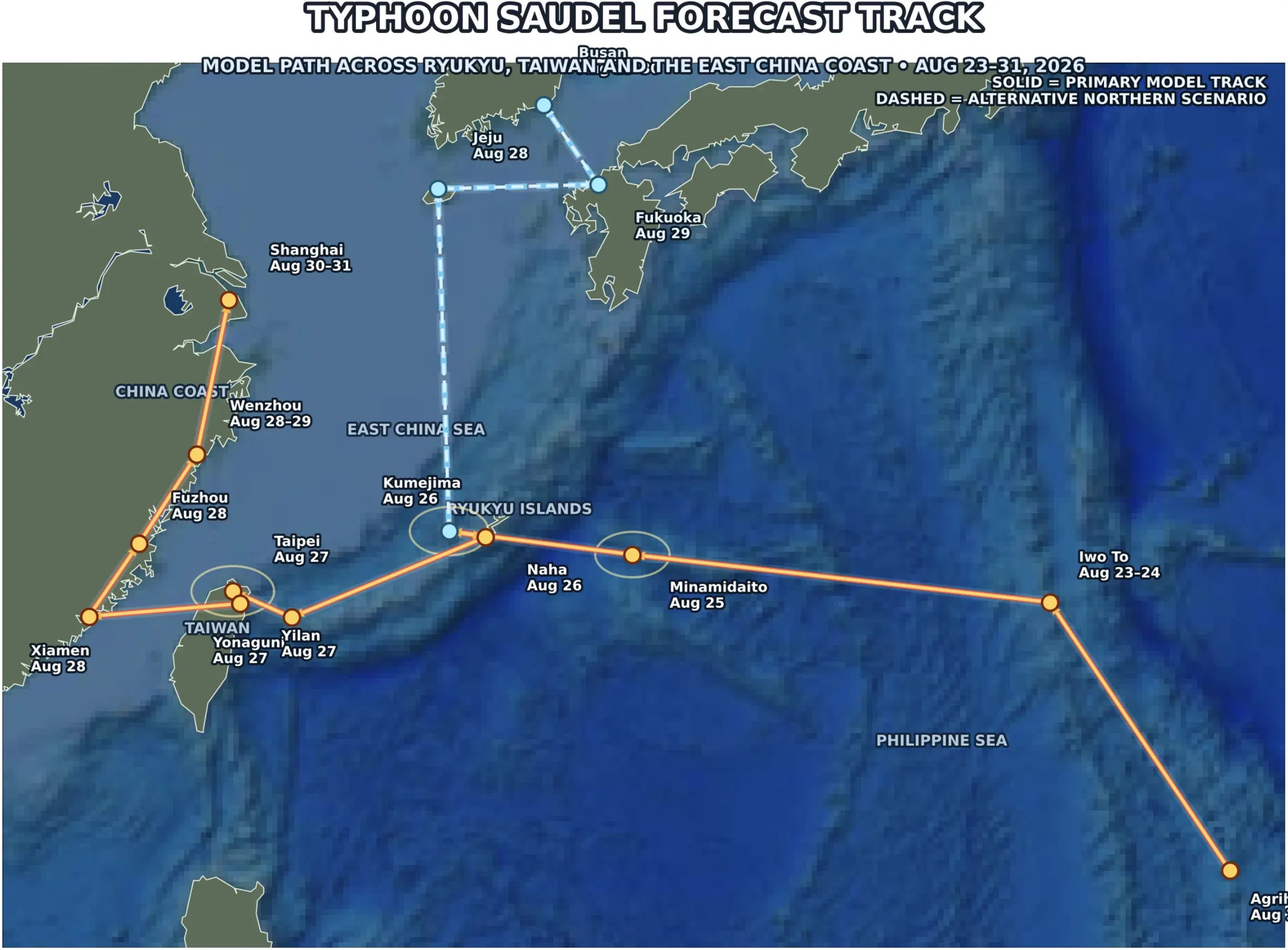
Japan: Okinawa and Kumejima face the clearest organized storm threat as Typhoon Saudel passes the Ryukyu Islands on August 26.
Europe: Amsterdam, Prague, Berlin and Zurich turn stormier around August 27–31, while Vienna has a high-end wind-gust signal above 80 km/h.
United States: Phoenix remains under an Extreme Heat Warning, with model temperatures peaking near 47.6°C / 118°F on August 26.
Lower Mississippi Valley: NOAA/WPC has a Marginal Risk of excessive rainfall on August 26 from parts of the Southwest and Rockies to the Central Plains and Lower Mississippi Valley.
India: Uttarakhand remains in a widespread wet pattern through August 31, while Gangetic West Bengal has a heavy-rain window from August 28–30; Kolkata’s model rainfall peaks near 49 mm on August 29.
Global severe weather hotspots at a glance
Region
Location
Peak window
Main hazard
Key forecast signal
Japan
Naha / Okinawa
Aug 25–27
Typhoon wind, thunderstorms, heavy rain
Gusts near 86–94 km/h; 20–27 mm/day
Japan
Kumejima
Aug 26
Typhoon wind and rain
~33 mm rain; gusts near 85 km/h
Europe
Vienna
Aug 28–29
Strong wind after heat
Model gusts ~83 km/h Aug 28 and ~78 km/h Aug 29
Europe
Amsterdam
Aug 27–30
Repeated rain and thunderstorms
~17 mm Aug 28; ~15 mm Aug 30
Europe
Prague
Aug 28
Thunderstorm / heavy rain
~17 mm rain with thunderstorm code
Europe
Berlin
Aug 28
Thunderstorm / heavy rain
~15 mm rain with thunderstorm code
Europe
Zurich / Alps
Aug 27–31
Heat break, thunderstorms, Alpine rain
31.5°C → 23.9°C; ~14 mm rain Aug 28
USA
Phoenix
Aug 25–29
Extreme heat
47.6°C / 118°F Aug 26; official Extreme Heat Warning
USA
Dallas
Aug 27–Sep 1
Persistent dangerous heat
40–41°C / 104–106°F on multiple days
India
Kolkata / Gangetic West Bengal
Aug 28–31
Heavy monsoon rain, thunderstorms
~49 mm Aug 29; ~37 mm Aug 30
India
Dehradun / Uttarakhand
Aug 26–31
Repeated thunderstorms, heavy rain, slope/flash-flood risk
Rain every day; IMD heavy-rain periods Aug 25–26 and 30–31
India
Gangtok / Sikkim
Aug 26–31
Mountain rain and localized landslide risk
~18 mm Aug 26 and ~17 mm Aug 31
Japan: Typhoon Saudel is the most organized severe-weather threat
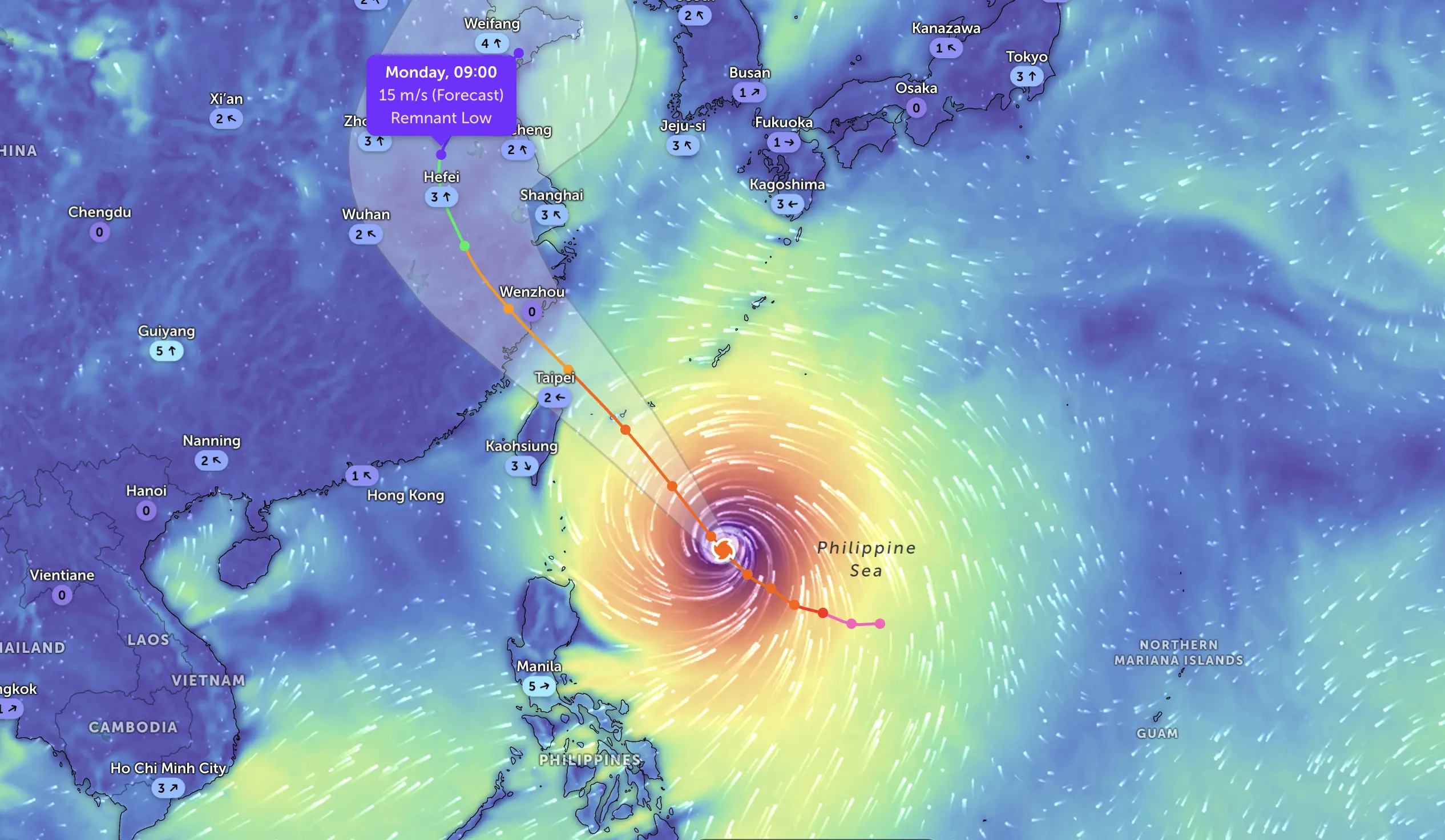
The clearest storm threat in this entire outlook is Typhoon Saudel. GDACS/JTWC classifies Saudel as an Orange tropical cyclone, with Japan among the exposed countries and a landfall window around August 25–26. GDACS has indicated maximum winds along the cyclone track above 200 km/h, while the city-level Pogodnik forecast is naturally much lower because it represents a grid point on land rather than the storm’s maximum wind near the center.
For Naha, Okinawa, Pogodnik currently shows around 20 mm of rain on August 25 and 27 mm on August 26. Maximum city-grid gusts reach roughly 94 km/h on August 25 and 86 km/h on August 26. Thunderstorm-related WMO weather codes remain in the forecast through August 27.
Kumejima, west of Okinawa’s main island, is even closer to the expected core corridor. The August 26 city-point forecast gives about 33 mm of rain and maximum gusts around 85 km/h. Even if the precise track shifts, the Ryukyu Islands remain the highest-confidence severe-weather zone in this article.
Why the numbers can look confusing: Typhoon-center wind estimates from JTWC/GDACS can exceed 200 km/h while a city forecast shows gusts near 80–100 km/h. These values measure different things. The first describes the cyclone’s strongest winds near its core; the second is a model estimate for a specific land grid point. A small track shift can dramatically change the local number.
For broader Japan travel planning, Pogodnik also provides forecasts for Tokyo, although Tokyo is not currently the main Saudel impact zone.
Europe: a storm boundary sharpens around August 27–31
Europe’s severe-weather signal is more fragmented than Japan’s. There is no single continent-wide cyclone in the current forecast. Instead, a warm sector over Central Europe is followed by a more active Atlantic and frontal pattern, increasing the risk of thunderstorms, stronger gusts and short-duration heavy rain.
Amsterdam: repeated rain and a thunderstorm window
Amsterdam is one of the most persistent wet signals in the European forecast. Pogodnik gives roughly 6 mm on August 27, 17 mm on August 28 and 15 mm on August 30. August 28 carries a thunderstorm weather code, while August 30 has a heavy-shower signal.
Wind also increases late in the period. By August 31, model gusts reach roughly 59 km/h. This is below a classic damaging-wind threshold, but the repeated rain plus stronger wind makes the Netherlands one of the more credible multi-day unsettled zones.
Vienna: 34°C heat followed by a high-end wind signal
Vienna has one of Europe’s most striking model contrasts. The city warms to about 33.8°C on August 28, while the deterministic Pogodnik forecast simultaneously produces maximum gusts near 82.8 km/h. August 29 still carries gusts around 78 km/h.
Those are important numbers, but they should be treated as a high-end model signal, not as an official Austrian wind warning. The strongest gust values need confirmation from later runs and national warning products as the front approaches.
Prague and Berlin: thunderstorm rain around August 28
In Prague, temperatures rise close to 29°C on August 27–28, then the model brings around 17 mm of rain on August 28 with a thunderstorm weather code. Gusts are less extreme than Vienna but could still approach 45–50 km/h.
Berlin shows a similar frontal timing: around 15 mm of rain on August 28 and a thunderstorm signal. The current run is less extreme than earlier forecasts that showed 30+ mm, which is a reminder that convective rainfall can change substantially from run to run.
Zurich: an 8°C heat collapse and Alpine thunderstorms
Zurich may jump to about 31.5°C on August 27, then fall to only 23.9°C on August 28. The same day brings roughly 14 mm of rain with a thunderstorm code.
Another storm signal appears on August 31. Because Alpine terrain can strongly enhance rainfall and storm development, city-grid totals should not be treated as an upper limit for surrounding mountain areas.
Athens: severe weather of a different kind — persistent heat
While Central Europe turns stormier, Athens remains hot and almost completely dry. Pogodnik gives around 37°C on August 26–27 and another rise to roughly 37°C on August 31, with nighttime temperatures remaining in the mid-20s Celsius.
That makes heat stress — rather than thunderstorms — the main hazard in Greece.
United States: an official Extreme Heat Warning in Phoenix
Phoenix is under an official NWS Extreme Heat Warning. The National Weather Service says dangerously hot conditions with afternoon temperatures roughly 106–116°F are expected across the Phoenix metropolitan area, with Major to Extreme HeatRisk. The warning is in effect through Saturday evening.
The Pogodnik city forecast for Phoenix is even hotter on August 26: approximately 47.6°C, or 117.7°F.
The overnight heat is equally important. Minimum temperatures remain above 30°C on several nights, and the model has an exceptionally warm nighttime value near 36–37°C during the hottest part of the period. Even if that exact number changes, there is very little nocturnal relief.
By August 29–30, temperatures fall somewhat, but still remain extremely hot by most standards. A small monsoon-rain signal returns around August 30, when the model gives about 4 mm.
Dallas: repeated 104–106°F heat
Dallas also remains under intense late-summer heat. Pogodnik shows highs near 40–41°C / 104–106°F on August 27–30, with very warm nights around 28–30°C.
A weak rain break appears on August 26, but it does not end the larger heat pattern. The city rapidly returns above 40°C afterward.
Flash-flood risk from the Southwest to the Lower Mississippi Valley
Heat is not the only U.S. hazard. NOAA’s Weather Prediction Center has a Marginal Risk of excessive rainfall for August 26 across portions of the Southwest and Rockies into the Central Plains and Lower Mississippi Valley.
WPC specifically highlights the Ozarks and Lower Mississippi Valley as a corridor where high atmospheric moisture may support heavier thunderstorm rainfall. Precipitable-water values are forecast above 2 inches in parts of the Lower Mississippi Valley, including eastern Louisiana and Alabama.
This does not mean every city will flood. It means localized thunderstorms could produce rainfall rates high enough to create flash-flood problems, especially where storms repeat over the same area.
India: the monsoon risk broadens again
India’s hazard is not one isolated cyclone. It is a broad monsoon setup with repeated heavy-rain and thunderstorm windows across several regions.
Kolkata and Gangetic West Bengal: the strongest city-scale rain signal
Pogodnik currently gives Kolkata a major rainfall increase late in the week:
August 29: about 48.9 mm
August 30: about 36.9 mm
August 31: about 16.8 mm
September 1: about 18.6 mm
Thunderstorm-related WMO codes remain in the forecast through this period.
This is supported by the India Meteorological Department. IMD’s August 25 evening bulletin calls for fairly widespread to widespread rainfall over Gangetic West Bengal from August 25–31, with isolated heavy rainfall during August 28–30. IMD also highlights thunderstorms, lightning and gusty winds over West Bengal and Sikkim during much of the period.
Uttarakhand / Dehradun: repeated rain, thunderstorms and terrain risk
In Dehradun, Pogodnik shows rain every day from August 26 through August 31, generally around 6–13 mm per day, with repeated thunderstorm codes.
IMD is more important than any single city-grid number here: it forecasts fairly widespread to widespread rainfall across Uttarakhand from August 25–31, with heavy rainfall during August 25–26 and again August 30–31. Thunderstorms and lightning are also expected throughout the period.
In mountain terrain, the main concern is not just urban flooding. Repeated rain can increase the risk of landslides, road disruption, debris flows and rapid rises in small streams.
Gangtok / Sikkim: mountain rainfall remains active
Gangtok’s Pogodnik forecast has around 18 mm on August 26 and another 17 mm on August 31. IMD expects heavy rainfall over Sub-Himalayan West Bengal and Sikkim during August 25–28, along with thunderstorms, lightning and gusty winds.
The exact city total is less important than the broader mountain signal. Orographic rainfall can vary sharply over short distances, and steep terrain increases sensitivity to runoff and slope instability.
Which hazards are most dangerous?
Typhoon Saudel is the most organized storm system because it has a defined tropical-cyclone circulation and an official GDACS/JTWC track near Japan.
Phoenix has the clearest officially warned heat emergency: an NWS Extreme Heat Warning with temperatures in the 106–116°F range and Major to Extreme HeatRisk.
India has the broadest rainfall footprint. The IMD warning area covers multiple states and several consecutive days, with heavy or very heavy rain in different regions.
Europe has the greatest uncertainty in exact local storm intensity. The broad frontal transition is credible, but city-scale rain and wind peaks can shift significantly as August 28–31 approaches.
Day-by-day severe-weather timeline
Date
Most important severe-weather zones
August 26
Saudel near Okinawa/Kumejima; Phoenix extreme heat; WPC excessive-rain risk from Southwest/Rockies to Central Plains and Lower Mississippi Valley; heavy rain risk in Uttarakhand/Sikkim.
August 27
Saudel impacts begin easing around Okinawa but strong gusts remain; Central Europe heats up ahead of the front; Dallas heat strengthens.
August 28
Amsterdam, Prague, Berlin and Zurich turn stormier; Vienna reaches its strongest wind signal; Gangetic West Bengal enters its heavy-rain window.
August 29
Kolkata rainfall peaks near 49 mm; Vienna wind remains strong; Amsterdam stays unsettled; Phoenix remains under dangerous heat.
August 30
Repeated rain around Amsterdam; Kolkata remains very wet; IMD heavy-rain risk returns to Uttarakhand; Dallas heat peaks near 41°C.
August 31
India remains active from Uttarakhand to Gangetic West Bengal; Athens heats back toward 37°C; parts of Central Europe stay unsettled.
September 1
Kolkata remains wet; European storm activity becomes more fragmented; U.S. heat persists in the southern tier.
Track these locations on Pogodnik
For local temperature, rain, wind and hourly updates, these Pogodnik location pages were verified before publication:
Indian city links were intentionally not inserted because exact Pogodnik location URLs for Kolkata, Dehradun and Gangtok could not be reliably verified in the public search index. They were not guessed.
Safety: what travelers and residents should do
In Okinawa, follow Japanese local emergency instructions and avoid exposed coastal areas during Saudel’s closest approach. Tropical-cyclone conditions can deteriorate rapidly even if city-level forecasts appear lower than storm-center wind estimates.
In Phoenix and the Desert Southwest, minimize strenuous outdoor activity during the hottest hours. The NWS warns that heat illness can escalate quickly under Major to Extreme HeatRisk, especially when nights remain very warm.
Across Central Europe, travelers should monitor local warnings around August 28–31. Thunderstorm tracks can shift by tens of kilometers, changing who receives the strongest wind or heaviest rain.
In India, avoid flooded roads and pay particular attention to landslide-prone mountain routes in Uttarakhand and Sikkim. Lightning remains a major hazard during monsoon thunderstorms even where total rainfall is moderate.
The world is entering a high-impact weather window between August 26 and September 1.
Japan faces the most organized storm threat as Typhoon Saudel passes the Ryukyu Islands. Phoenix faces the most extreme heat, with an official NWS warning and temperatures close to 118°F. Europe faces the sharpest frontal transition, with thunderstorms and stronger winds developing after late-summer warmth. And India faces the broadest flood-and-thunderstorm footprint, with IMD warnings spanning several regions and multiple days.
The most important forecast rule for this period is simple: do not focus on one dramatic model number. Watch whether the signal survives each new forecast cycle and whether official warning agencies begin upgrading the threat.
Prepared for Pogodnik using current model guidance and official warning products. Forecast details can change rapidly, especially for tropical cyclones, thunderstorms and localized heavy rainfall. Updated August 25, 2026.
The Founder and Chief Meteorologist at Pogodnik.com. With over 15 years of operational experience in synoptic analysis and climate forecasting, he specializes in storm tracking, magnetic storms, and atmospheric dynamics. A recognized expert in Ukraine’s meteorological sector, he maintains strategic collaborations with global agencies, including NOAA and ECMWF, to ensure high-precision data integration. His analytical reviews and scientific contributions are regularly featured in leading media outlets dedicated to weather science and environmental trends.