Europe Heat Dome 2026: Heatwave, Wildfires, Atlantic Cooldown and the U.S. Warning Signal
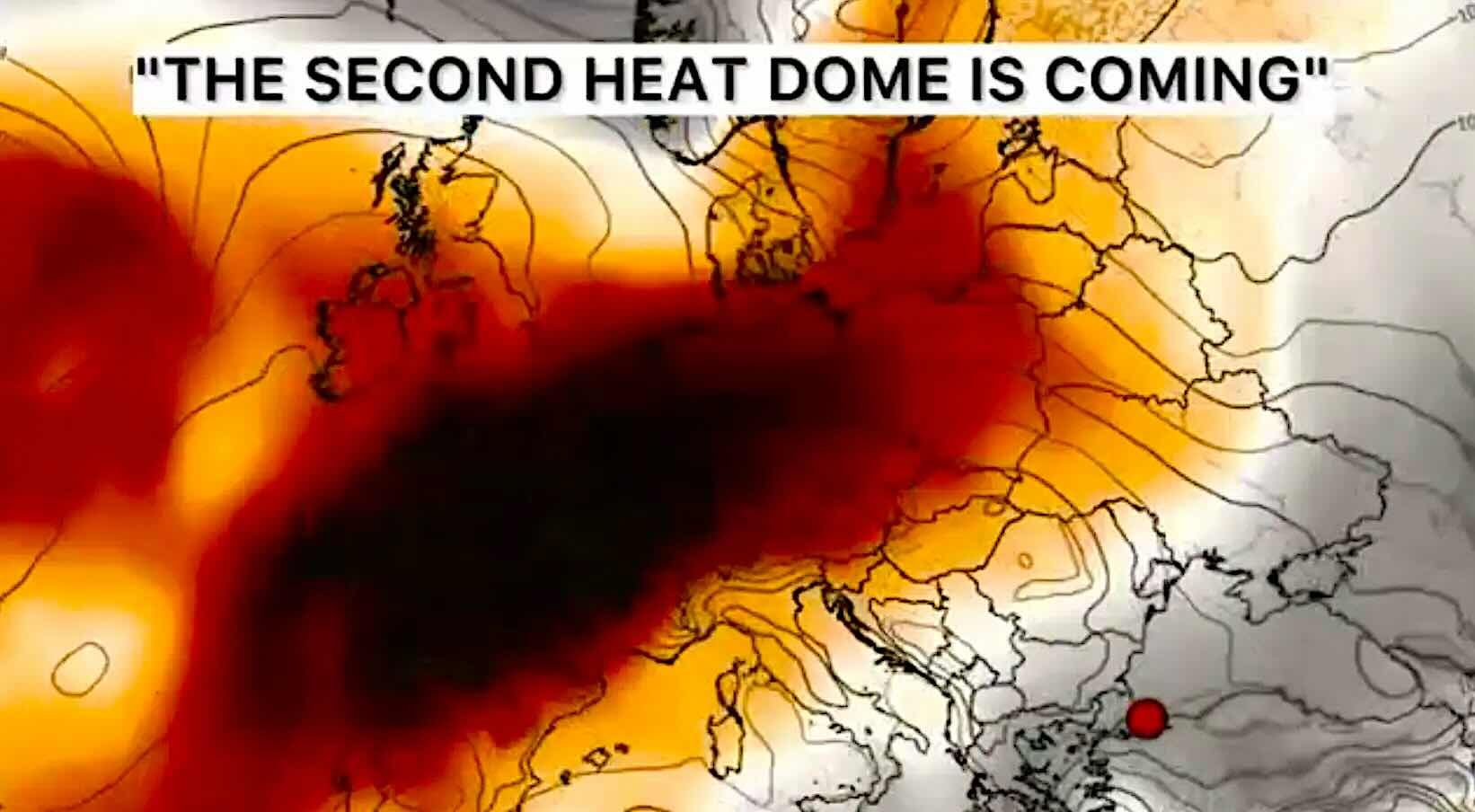
Europe is entering another dangerous weather phase: extreme heat is rebuilding over Spain, Portugal and France, wildfire pressure is rising across the south, and storm-producing fronts are pushing into Central and Eastern Europe. At the same time, the United States is under a historic Fourth of July heat dome affecting more than 200 million people — a warning sign that the same blocking pattern can turn summer heat into a multi-system emergency on both sides of the Atlantic.
Main Europe risk: Spain, Portugal and southern France remain the core of the heatwave, with local temperatures near or above 40°C and fire danger staying high.
Cooldown signal: cooler Atlantic air can temporarily break the heat across parts of Central and Eastern Europe, but the transition zone may produce thunderstorms, hail, squalls and flash flooding.
Global warning: the U.S. heat dome shows how dangerous this setup becomes when high pressure traps heat and humidity for days, forcing heat index values into the 105–115°F range and keeping nights dangerously warm.
What to watch after July 12–14: if the European ridge rebuilds, heat may again expand north and east into France, the Alps, northern Italy, Germany, the Balkans and possibly the western edge of Eastern Europe.
Track heat, storms, wildfire smoke and air quality in Pogodnik
During a week like this, a single temperature number is not enough. Use Pogodnik to check hourly weather, thunderstorms, wind, rainfall, wildfire maps, air quality and magnetic storm updates for your location. This is especially important when heat, smoke, fires, heavy rain and severe thunderstorms are happening close together.
Europe is heating up again: the southern heat dome is rebuilding
The most intense heat is now concentrated across southern and western Europe. Spain has issued a special heatwave warning, and current alerts point to maximum temperatures up to 43°C around the Guadalquivir Valley. This is no longer just “hot summer weather.” At this level, roads, railways, power demand, hospitals and the human body all come under stress.
Portugal is also in the danger zone. Heat warnings are active across inland districts, including Beja, Castelo Branco, Évora and Portalegre, where both daytime and nighttime temperatures are dangerously high. The night matters as much as the afternoon: when the air does not cool, the body cannot recover.
France is entering another high-risk heat episode after its historic June heat. Météo-France reported 40.8°C in Moules-et-Baucels, 40.7°C in Pissos and 40.4°C in Narbonne on July 6. For Narbonne, that was an unprecedented July value.
Forecasts for France point to widespread 36–38°C, with 38–40°C and locally higher values in the southwest and near the Gulf of Lion. The problem is not only the peak temperature. The real danger is duration: several hot days and warm nights in a row can turn a heatwave into a health and infrastructure emergency.
Southern Europe is burning: heat dome turns drought into wildfire risk
Under a heat dome, dry vegetation, low humidity and wind can quickly turn a fire risk into an evacuation crisis. In southern France, a major wildfire near the Spanish border forced more than 10,000 people from their homes across roughly two dozen communities. The fire burned about 4,600 hectares, and 16 people were reported injured, including four firefighters.
Spain and Portugal are also dealing with active fire pressure. In Spain, fires have burned thousands of hectares in vulnerable natural areas, while in Portugal the Vouzela area has seen estimates of burned land reaching roughly 10,000–13,000 hectares. Even before final financial damage estimates are available, the impact is already clear: evacuations, road closures, emergency aviation, tourism disruption and ecological damage.
For Europe, wildfire risk is no longer a secondary effect of heat. It is part of the same event. Heat dries fuels, dry fuels feed fires, smoke worsens air quality, and air quality then becomes a public health issue for cities far from the flames.
Pogodnik helps monitor fire and air-quality conditions
During hot and windy weather, check not only temperature but also nearby fire activity, smoke and air quality. Pogodnik includes a wildfire map and air-quality information, helping you decide whether to travel, exercise outside, visit forests or delay outdoor plans.
The U.S. heatwave is not the main European story, but it is a powerful warning signal. Severe Weather Europe describes a historic heat dome over the central and eastern United States, where a blocking high-pressure “lid” traps heat and humidity across more than two-thirds of the contiguous country. More than 200 million Americans are directly affected by dangerous heat, while more than 230 million are expected to experience daytime highs above 90°F.
The most dangerous U.S. corridor stretches from the central states and Midwest into the Great Lakes, the Northeast, the Southeast and the I‑95 urban corridor, including New York City, Washington, D.C. and Philadelphia. Heat index values are forecast to climb into the 105–115°F range, while overnight lows in dense urban zones may fail to drop below 75–80°F.
Why does this matter for Europe? Because the mechanism is the same. When a blocking ridge stalls, hot air sinks, compresses and heats further. Clouds are suppressed, sunshine becomes relentless, and nights stay warm. In Europe, this same setup can turn Spain, Portugal, France, Italy, the Balkans and the UK into regional heat-risk zones, even if the exact temperature numbers differ.
The U.S. case also shows the infrastructure side of heat: air conditioning demand rises, grids strain, outdoor events become dangerous, livestock and wildlife suffer, and cities accumulate heat night after night. Europe faces the same pattern — but often with older housing, less air conditioning, dense historic city centers and vulnerable rail and power infrastructure.
Atlantic cooling does not cancel heat — it can sharpen Europe’s storm zone
A second important signal comes from the far North Atlantic. Severe Weather Europe describes a returning cold ocean anomaly, or “cold blob,” in the subpolar North Atlantic east of Newfoundland, with a tail linking back toward the Gulf Stream region. The core area is around 0.5–2°C colder than the same period last year, which is a meaningful change for ocean temperatures.
For Europe, this does not mean instant cold weather. Instead, it can be a sign of a more dynamic Atlantic pattern. Cold ocean anomalies in this region can coincide with shifts in pressure, the jet stream and storm tracks. When cooler Atlantic air pushes toward Europe while the south remains under a heat dome, the result is not a clean cooldown — it is often a collision zone.
That collision zone matters for France, Germany, the Alps, northern Italy, Czechia, Austria, Poland, Romania, the Balkans and Ukraine. A front can bring relief from heat, but it can also trigger heavy rain, hail, severe wind gusts and sudden flooding after several hot days.
Italy and Romania show what happens when heat meets a front
Italy has already seen the dangerous transition. After roughly two weeks of intense heat, severe thunderstorms, heavy rain and damaging wind hit parts of the country. In Veneto, firefighters responded to nearly 400 emergency calls after storms brought down trees, branches, poles and caused flooding, including inside homes.
Romania then showed the same risk on the eastern flank of Europe. After temperatures above 40°C, a severe storm struck Bucharest and 20 counties. Emergency services received more than 2,200 calls, water had to be pumped from hundreds of homes and streets, about 1,000 trees were brought down, and nearly 500 vehicles were damaged.
This is the European storm warning after a heat dome: the worst weather may arrive not during the hottest hour, but when cooler air finally reaches overheated and humid air near the surface.
United Kingdom: heat returns, but not like the June extreme
The United Kingdom is also moving back into a warmer pattern. Health heat alerts are active in England for the July 4–11 period, with the southeast expected to peak around 34°C on July 9–10.This is not expected to be as extreme as the late-June heat episode, but warm nights, urban heat and vulnerable housing still matter. In the UK, many homes are designed to retain warmth, not to release heat during prolonged summer episodes. That makes even lower maximum temperatures risky for older people, people with chronic illness and households without effective cooling.
Super El Niño and warm oceans: the global background behind Europe’s extremes
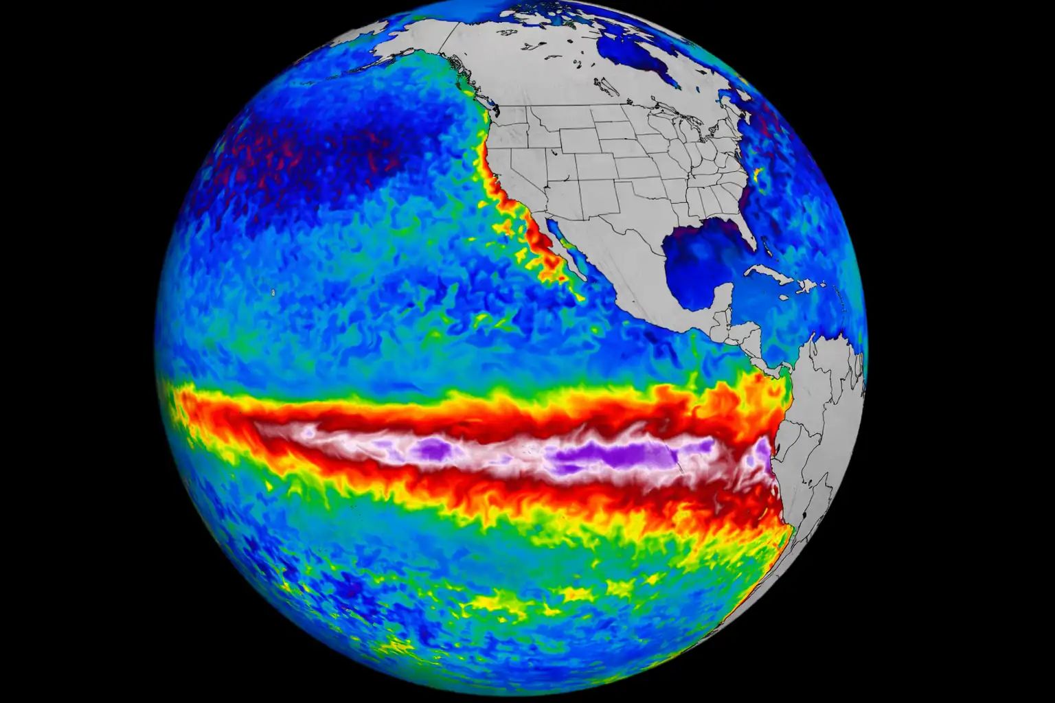
The global background is becoming more energetic. NOAA keeps an El Niño Advisory active, with El Niño conditions present and forecast to strengthen toward winter 2026/2027. Severe Weather Europe also highlights a developing Super El Niño signal in the tropical Pacific, while the cold North Atlantic anomaly remains visible in long-range ocean forecasts.
This does not mean every heatwave, storm or wildfire comes directly from El Niño. But it does mean the global system is loaded with stronger contrasts: warm oceans, cold anomaly zones, stronger pressure gradients, more moisture and more available energy for extreme events.
Copernicus Marine has also reported persistent ocean warmth and expanding marine heatwaves in the first half of 2026. A warmer ocean surface gives the atmosphere more water vapor and more energy. For Europe, that can amplify heavy rain events, while heat domes over land can intensify drought, fire risk and hot nights.
Europe forecast: July 7–14 risk map
Period
Risk zone
Expected weather
Main danger
July 7–9
Spain, Portugal, southern and southwestern France
Maximums around 38–43°C, locally above 40°C
Heat and wildfires
July 7–10
Central Europe: Germany, Alps, Czechia, Austria, Poland
Cooler Atlantic air pushes into hot air; scattered storms and local severe weather
Storms after heat
July 8–10
United Kingdom and parts of Ireland
Heat builds again, with southeast England peaking near 34°C
Warm nights
July 9–12
Italy, Balkans, Romania, parts of Eastern Europe
High contrast between heat and fronts; heavy rain, hail and squalls possible
Severe thunderstorm clusters
July 10–12
Taiwan, Ryukyu Islands, eastern China coast
Bavi may bring waves, surge, rain, wind and landslide risk
Typhoon
After July 12–14
France, Alps, northern Italy, Germany, Central Europe
Heat may return north and east if the ridge strengthens again
Heat return risk
After July 12–14
Europe-wide pattern
Forecast confidence decreases: either renewed heat ridge or another Atlantic frontal push
Pattern uncertainty
On July 7–9, the main European heat core is Spain, Portugal and southern to southwestern France. Temperatures around 38–43°C remain possible, with local values above 40°C. Fire danger stays high where dry vegetation and wind overlap.
On July 8–10, heat strengthens again across the United Kingdom and parts of Ireland, with southeast England likely to see the highest values. This is not expected to match the June extreme, but duration and warm nights still increase health risk.
On July 9–12, the storm corridor becomes important from Italy and the Balkans into Romania and parts of Central and Eastern Europe. Where hot air is forced out by fronts, severe thunderstorms may develop quickly.
After July 12–14, Europe faces a fork in the road: either the ridge rebuilds and heat expands north and east again, or Atlantic fronts keep pushing into the continent and maintain a more unsettled pattern. This is the point where daily model updates matter most.
Why Europe should watch the U.S. heat dome closely
The U.S. heat dome is not a European forecast map, but it is a real-time case study of what happens when a blocking ridge becomes strong and stable. In the U.S., the event is affecting more than 200 million people, with heat index values climbing past 110°F in many areas and hot nights adding cumulative stress.
Europe has the same vulnerability pattern: dense cities, aging populations, railways sensitive to heat, high power demand, wildfire-prone landscapes and homes that are often poorly adapted for long hot nights. When a European heat dome stalls, the risk is not only the afternoon maximum. It is the multi-day accumulation.
That is why the U.S. event matters for readers in Europe: it shows how quickly a heatwave can become a public health, transport, energy and wildfire problem at the same time.
Check heat, storms and fire maps before travel
This week, check more than the daily maximum. Look at thunderstorms, wind gusts, rainfall timing, air quality and wildfire risk. Pogodnik helps you monitor the forecast for your current location and plan travel, outdoor work and family activities more safely.
Europe’s July weather is no longer just “hot in the south and rainy in the north.” It is a collision of weather regimes. A heat dome is holding extreme temperatures over southern Europe. Atlantic fronts are trying to break into the continent. The North Atlantic cold anomaly hints at a more dynamic jet-stream environment. The U.S. heat dome shows how dangerous a stalled ridge can become. And tropical systems like Bavi show how warm oceans can rapidly convert energy into destructive storms.
For Europe, the next key period is July 7–14. The biggest immediate heat risk remains Spain, Portugal and France. The highest severe-storm transition risk runs from northern Italy and the Alps toward the Balkans, Romania and parts of Central and Eastern Europe. After July 12–14, the question is whether Atlantic fronts keep pressing east or the ridge rebuilds and pulls heat back toward central Europe.
Safety advice for people in risk zones
During heat: avoid direct sun in the hottest part of the day, drink water regularly, reduce physical load and check on older people, children and people with chronic illness.
During wildfire danger: do not light fires, do not throw cigarette ends, and avoid forest travel without checking local warnings.
During thunderstorms and squalls: avoid isolated trees, open fields, water, metal structures and temporary outdoor installations.
During heavy rain: do not drive across flooded roads and do not park in low-lying areas, under trees or near unstable structures.
During typhoon threat: prepare water, documents, medicine, phone power, food supplies and an evacuation route before warnings escalate.
During hot nights: cool the home early, ventilate only when outdoor air is cooler, and do not rely only on daytime temperature forecasts.
FAQ
Where is the strongest heat in Europe now?
The most dangerous heat zones for July 7–9 are Spain, Portugal and southern to southwestern France, where maximum temperatures around 38–43°C are possible and local values may exceed 40°C.
Why is the U.S. heat dome relevant for Europe?
The U.S. heat dome uses the same atmospheric mechanism: a blocking high-pressure ridge traps heat and humidity for days. It shows how quickly heat can become a health, energy, transport and infrastructure emergency.
Can the Atlantic cooldown stop the European heatwave?
Not directly. Cooler Atlantic air can temporarily break heat in Central and Eastern Europe, but if the southern ridge remains strong, the result may be a stormy transition rather than a stable cooldown.
Where is the highest severe-storm risk after the heat?
The highest storm-transition risk runs from northern Italy and the Alps toward the Balkans, Romania and parts of Central and Eastern Europe, where hot air can collide with incoming cooler air.
Could heat return to Central Europe after July 12–14?
Yes. If the ridge strengthens again, heat may expand north and east into France, the Alps, northern Italy, Germany and parts of Central Europe. If Atlantic fronts stay active, the pattern may remain more unsettled.
What is the main risk for European cities?
The main urban risk is cumulative heat: hot days followed by warm nights. When nights stay warm, the body and buildings do not recover, raising health risks even if the daytime maximum is not record-breaking.
The Founder and Chief Meteorologist at Pogodnik.com. With over 15 years of operational experience in synoptic analysis and climate forecasting, he specializes in storm tracking, magnetic storms, and atmospheric dynamics. A recognized expert in Ukraine’s meteorological sector, he maintains strategic collaborations with global agencies, including NOAA and ECMWF, to ensure high-precision data integration. His analytical reviews and scientific contributions are regularly featured in leading media outlets dedicated to weather science and environmental trends.