Hurricane Season and U.S. Landfalls: Why 2026 May Be Quieter, But Still Dangerous
The 2026 Atlantic hurricane season is shaping up as one of the most interesting forecast puzzles in years. A fast-developing El Niño may suppress storm formation across the tropical Atlantic, yet warm waters near parts of the western Atlantic and Gulf Coast mean U.S. landfall risk cannot be dismissed. For homeowners from Texas to Florida, the Carolinas and the Northeast, the message is simple: fewer storms does not mean zero danger.
Key takeaways: The 2026 Atlantic hurricane season is expected by several major forecast groups to be near or slightly below average, mainly because El Niño tends to increase wind shear over the Atlantic. CSU forecasts 13 named storms, 6 hurricanes and 2 major hurricanes. TSR is more aggressive on the quiet side, with 12 named storms, 5 hurricanes and 1 major hurricane. NC State is closer to average, with 12–15 named storms and 6–9 hurricanes. AccuWeather forecasts 11–16 named storms and warns of 3–5 direct U.S. impacts. The biggest risk for the United States is not the total storm count — it is whether one storm finds a short window of favorable conditions close to land.
2026 Atlantic hurricane season: the setup
The official Atlantic hurricane season runs from June 1 through November 30, with the climatological peak around September 10 and the most active stretch usually from mid-August through mid-October. The Atlantic basin includes the open Atlantic, the Caribbean Sea and the Gulf region — three very different storm environments that can behave differently in the same year.
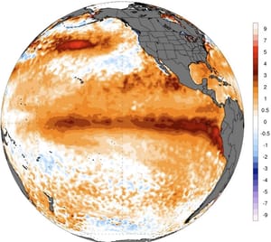
For 2026, the dominant climate signal is the rapid transition toward El Niño in the tropical Pacific. El Niño is not an Atlantic phenomenon, but it can reshape the upper-level wind pattern across the Atlantic basin. When El Niño strengthens, stronger westerly winds aloft often spread across the Caribbean and tropical Atlantic. That increases vertical wind shear, which can tilt developing storms, tear apart their thunderstorm core and prevent them from organizing into hurricanes.
That is the “atmospheric shield” idea behind many 2026 forecasts. But the shield is not perfect. It can weaken for a few days, shift north or south, or fail to cover the Gulf Coast and western Atlantic at the wrong time. That is why U.S. landfall risk must be analyzed separately from basin-wide storm numbers.
Forecast comparison: what the major hurricane outlooks say
Forecast source
Named storms
Hurricanes
Major hurricanes
Main message
Colorado State University
13
6
2
Somewhat below normal because El Niño may increase Atlantic wind shear
Tropical Storm Risk
12
5
1
Around 40% below the 1991–2020 norm, with reduced landfall numbers
NC State University
12–15
6–9
2–3
Near recent averages, with Gulf activity close to normal and Caribbean activity slightly lower
AccuWeather
11–16
4–7
2–4
Near to below average, but with 3–5 direct U.S. impacts possible
1991–2020 Atlantic average
14
7
3
Baseline for comparing seasonal activity
The forecast spread is important. CSU and TSR lean toward a quieter season. NC State is closer to a normal year. AccuWeather agrees that the season may not be hyperactive, but it highlights the practical risk that matters most to Americans: direct impacts. A season can finish below average and still produce a damaging U.S. landfall.
Why El Niño usually suppresses Atlantic hurricanes
El Niño warms the central and eastern tropical Pacific and changes the global circulation pattern. In the Atlantic, that often means three hostile ingredients for hurricanes: stronger vertical wind shear, more sinking air and drier mid-level air. Hurricanes need a vertically stacked circulation, deep moisture and persistent thunderstorm bursts near the center. El Niño attacks all three.
El Niño effect
Impact on hurricanes
Why it matters for the U.S.
More vertical wind shear
Disrupts storm structure and weakens developing systems
Long-track Cape Verde hurricanes become less likely
Sinking air over parts of the Atlantic
Suppresses thunderstorm growth
The Main Development Region can become less productive
Drier mid-level atmosphere
Injects dry air into tropical waves
Storms struggle to intensify before reaching the Caribbean or U.S.
Enhanced Pacific activity
Energy shifts toward the eastern Pacific basin
The Atlantic can be quieter while the Pacific is more active
The key phrase is “usually suppresses.” El Niño lowers the odds of a hyperactive Atlantic season, but it does not shut down the basin. If a storm forms closer to the coast — in the Gulf, near the Bahamas or off the Southeast coast — it may not need a long journey across the hostile deep tropics. Short-track storms can still intensify quickly if local water temperatures, moisture and upper-level winds briefly line up.
The landfall problem: why a quieter season can still hit hard
Landfall risk is not controlled only by how many storms form. It also depends on where storms form, how steering currents evolve, whether high pressure blocks a recurvature path, and whether the Gulf Coast or Southeast coast sits near a weakness in the steering flow. This is why the U.S. can experience damaging hurricanes even in a season that looks modest on paper.
The biggest danger in 2026 may be a “homegrown” system: a storm that forms close to land in the Gulf, western Caribbean, near the Bahamas or off the Southeast coast. These systems often have less ocean distance to cover but can still produce high-impact hazards, especially heavy rainfall, storm surge and inland wind damage.
Regional U.S. landfall outlook
Region
2026 risk signal
What to watch
Preparation focus
Texas Coast
Lower than a classic La Niña year, but not zero
Western Gulf disturbances, late-season fronts, weak steering currents
Forecast analyst note: the Atlantic may be split in two
One of the most useful ways to view 2026 is not “active or inactive,” but “where is the basin hostile and where can it open a window?” The deep tropical Atlantic may be suppressed by El Niño-related wind shear and sinking motion. But the western Atlantic and Gulf region can behave differently, especially if local sea surface temperatures are warm and shear temporarily relaxes.
This split-basin pattern is why a simple storm-count forecast can be misleading for the public. A weaker Main Development Region reduces the odds of long-track major hurricanes from Africa to the Caribbean. But it does not erase the risk of a late-forming storm near the U.S. coastline. For emergency managers, insurers and coastal residents, the landfall question is more important than the basin total.
What could make the 2026 season more active than expected?
There are several ways the season could overperform the quieter forecasts. First, El Niño may develop but fail to couple strongly with the atmosphere during the peak months. Second, Atlantic water temperatures could run warmer than expected near the western basin. Third, wind shear can relax for short but critical windows. Fourth, tropical waves can still find favorable pockets even in a hostile background pattern.
Upside risk factor
Why it matters
Possible result
Delayed atmospheric El Niño response
The ocean warms, but Atlantic wind shear does not increase fast enough
More storms than expected during August and September
Warm western Atlantic waters
Storms forming near land have more available heat energy
Higher risk for quick intensification close to the U.S.
Weak steering currents
Storms can slow down near the coast
Extreme rainfall and flooding risk increases
Active late-season Caribbean
October systems can form after peak shear patterns shift
Florida and the Gulf Coast remain exposed late in the season
What could make the 2026 season even quieter?
The quiet-case scenario is straightforward: El Niño strengthens early, wind shear becomes widespread across the Caribbean and tropical Atlantic, and the Main Development Region struggles to produce organized storms. If dry air is persistent and pressure is higher across the deep tropics, many tropical waves may fail before they can become named storms.
In that scenario, the season could resemble a suppressed Atlantic year with fewer long-track hurricanes and fewer major hurricanes. But even then, a single Gulf or Southeast coast storm could dominate the season’s impact.
New for 2026: the hurricane cone is changing
For U.S. residents, one of the most important operational changes is not the seasonal forecast — it is how warnings are displayed. In 2026, the National Hurricane Center’s operational cone graphic includes inland tropical storm and hurricane watches and warnings. That matters because hurricane impacts do not stop at the beach. Inland wind damage, power outages and flooding can extend far from the coastline.
NHC is also testing an experimental cone that uses ellipses rather than circles and is designed to better represent along-track and cross-track forecast errors. The practical takeaway is simple: do not treat the cone as an impact map. A storm’s rain, surge, tornadoes and damaging winds can occur outside the cone, while the cone itself mainly communicates uncertainty in the track of the storm center.
Most likely 2026 hurricane season scenario
The most likely outcome is a near- to slightly below-average Atlantic season with fewer long-track major hurricanes than a classic La Niña year. El Niño should work against the deepest tropical Atlantic, especially during the heart of the season. The U.S. landfall risk is probably lower than in an extremely active season, but it remains meaningful along the Gulf Coast, Florida and the Southeast.
The highest-impact scenario for the United States would be a short-track storm forming close to land during a brief shear minimum. These storms can be harder for the public to mentally prepare for because they may develop quickly and offer less lead time than long-track hurricanes crossing the Atlantic for a week.
Preparation guide for U.S. coastal residents
Before the season
During a storm watch
During a warning
Know your evacuation zone
Charge devices and power banks
Follow local evacuation orders immediately
Review insurance, including flood coverage
Secure outdoor furniture and loose objects
Stay away from windows and flooded roads
Prepare a 7-day supply kit
Fill prescriptions and fuel vehicles
Do not use generators indoors or in garages
Plan for pets, elderly relatives and medical needs
Check official NHC and local NWS updates
Expect inland impacts even away from the coast
El Niño helps, but it does not guarantee safety
The 2026 Atlantic hurricane season may not be a blockbuster on paper. El Niño is a legitimate suppressing force, and several major forecasts point toward near- or below-average activity. But U.S. hurricane risk is not measured only by seasonal totals. It is measured by landfalls, rainfall, storm surge, power outages and how prepared communities are before the first warning is issued.
If you live near the Gulf Coast, Florida, the Southeast coast or a flood-prone inland area, prepare as if one storm could find you. A quieter season can still be a costly season. In hurricane forecasting, the number that matters most is not how many storms form in the Atlantic — it is whether one of them reaches your coastline.
FAQ: 2026 hurricane season and U.S. landfalls
Will the 2026 Atlantic hurricane season be active?
Most current forecasts suggest a near- to slightly below-average season. CSU predicts 13 named storms, TSR predicts 12, NC State predicts 12–15 and AccuWeather predicts 11–16.
Why could El Niño reduce Atlantic hurricane activity?
El Niño often increases vertical wind shear over the Atlantic and Caribbean. Strong shear disrupts tropical storms and can prevent hurricanes from organizing or intensifying.
Does a quieter season mean the United States is safe?
No. A below-average season can still produce a damaging U.S. landfall. The greatest concern is a short-track storm forming close to the Gulf Coast, Florida, the Bahamas or the Southeast coast.
Which U.S. areas should watch the season most closely?
Texas, Louisiana, Mississippi, Alabama, Florida, Georgia, the Carolinas and parts of the Northeast should monitor the season closely. Inland communities must also prepare for wind and flooding impacts.
What is new from the National Hurricane Center in 2026?
The operational cone graphic now includes inland tropical storm and hurricane watches and warnings. NHC is also testing an experimental cone that uses ellipses to better represent forecast uncertainty.
The Founder and Chief Meteorologist at Pogodnik.com. With over 15 years of operational experience in synoptic analysis and climate forecasting, he specializes in storm tracking, magnetic storms, and atmospheric dynamics. A recognized expert in Ukraine’s meteorological sector, he maintains strategic collaborations with global agencies, including NOAA and ECMWF, to ensure high-precision data integration. His analytical reviews and scientific contributions are regularly featured in leading media outlets dedicated to weather science and environmental trends.