Japan Heavy Rain Alert: Former Typhoon Krovanh Fuels Flood and Landslide Risk
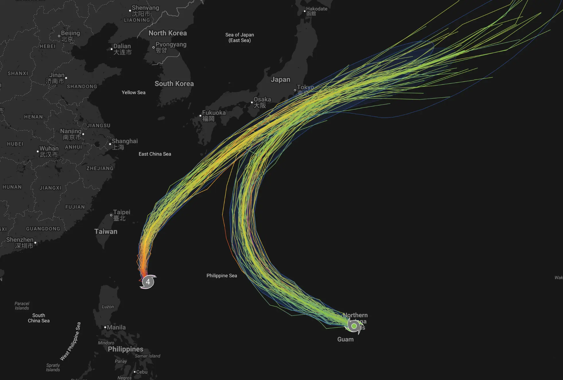
Japan’s weather emergency has changed again. Typhoon No. 24 Krovanh has weakened into a tropical depression, but its tropical moisture is now feeding a stalled autumn rain front across Japan — expanding the threat from a typhoon-track story into a widespread heavy-rain, flooding and landslide event.
Japan heavy rain — key risks now
線状降水帯: linear precipitation bands have formed in Aichi and Gifu.
名古屋 大雨: Nagoya is under Level 4 heavy-rain and landslide danger.
東京 雨: renewed heavy rain may spread into Kanto-Koshin overnight.
洪水警報 / 土砂災害: flooding and landslide risk remain elevated in saturated areas.
JR 運休 / JR東日本 運行状況: transport disruption can change quickly during intense rain bands.
Updated: September 8, 2026. This article uses current JMA and Weathernews warnings plus a fresh Weather Forecaster forecast model run.
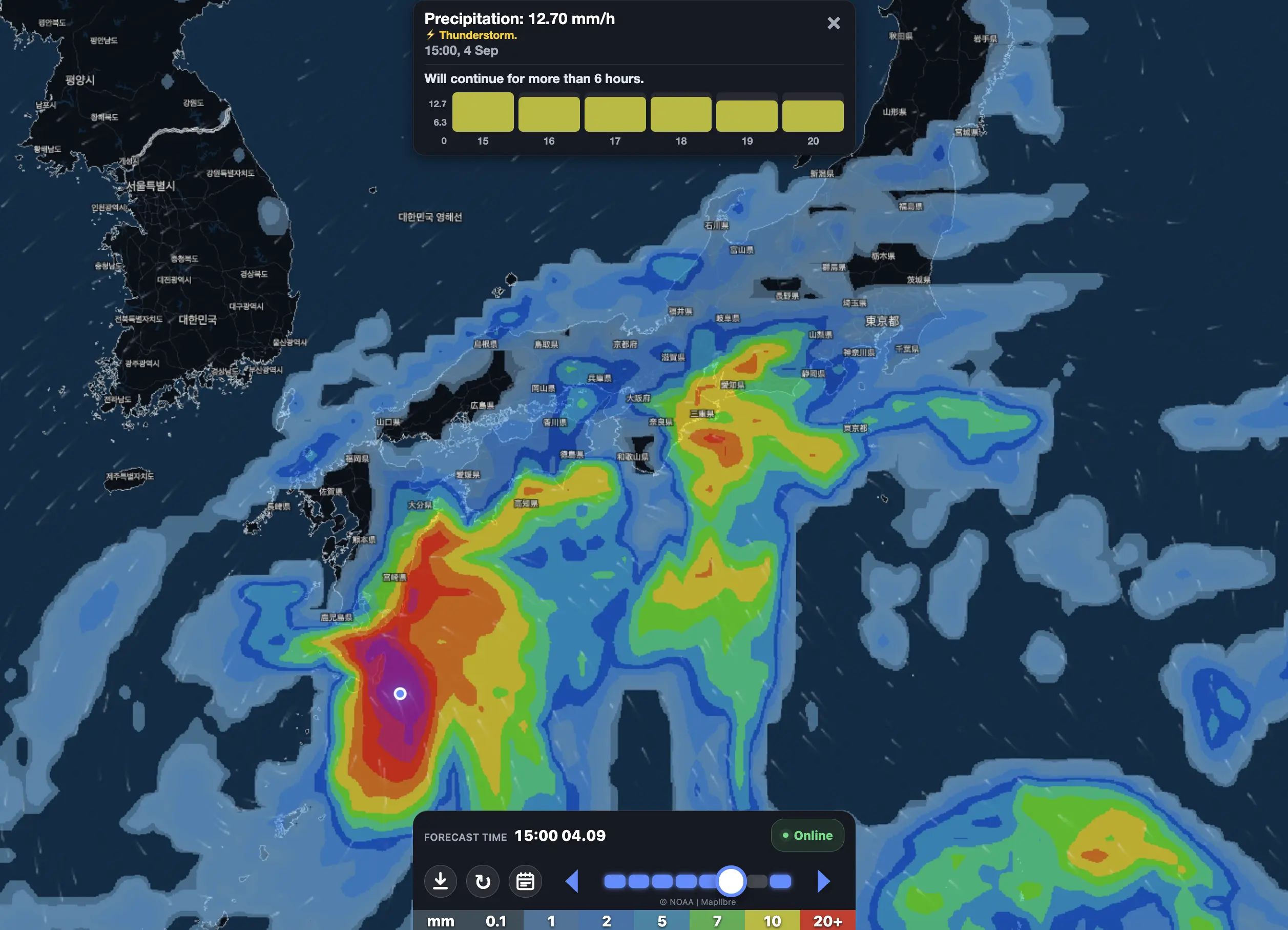
Heavy and very heavy rain is affecting a broad corridor from western Japan through Tokai and toward Kanto and Tohoku.
The most serious new development is in Aichi and Gifu, where a linear precipitation band — 線状降水帯 — has already formed.
102 mm/hr Observed at Komaki, Aichi
~100 mm/hr Estimated near Tajimi, Gifu
~150 mm / 3 hr Estimated in parts of Aichi–Gifu rain-band corridor
Level 4 Heavy-rain / landslide danger around Nagoya
Japan heavy rain — what matters now
Krovanh is no longer a typhoon: it has weakened into a tropical depression.
The danger has expanded: warm, humid tropical air is feeding Japan’s autumn rain front.
Tokai: a linear precipitation band has already formed over western Aichi and the Mino region of Gifu.
Nagoya: heavy-rain and landslide danger has reached Level 4 conditions.
Kanto-Koshin: heavy rain may intensify again Tuesday night into Wednesday morning.
Izu Islands / southern Chiba: ground remains highly saturated after record rainfall.
Main hazards: landslides, flash flooding, river flooding, lightning, hail and severe convective gusts.
Tornado-like violent gusts: possible near the strongest thunderstorms.
The search intent is now completely different.
Yesterday, the question was:
Where is Typhoon No. 24 going?
Today, the more urgent question is:
Where will Japan’s next extreme rain corridor form, and which areas face flooding or landslides?
Former Typhoon Krovanh is now a tropical depression
Krovanh has lost typhoon status, but that does not mean the meteorological threat has ended.
The tropical depression is moving north near western Japan while sending a deep plume of warm, moisture-rich air toward the autumn rain front stalled along the Pacific side of Honshu.
That moisture supply is helping thunderstorms repeatedly develop along the front.
The tropical depression is expected to become absorbed into a frontal low around September 9, while the autumn rain front remains active through approximately September 10.
Why a weaker tropical system can still cause extreme rain:
A tropical cyclone can lose its closed typhoon circulation while still carrying enormous amounts of tropical moisture.
When that moisture collides with a stationary front, rainfall can become more widespread than when the storm had a compact typhoon core.
Tokai emergency: linear precipitation band forms in Aichi and Gifu
This is the most important live update.
JMA reported a linear precipitation band over western Aichi and the Mino area of Gifu during the afternoon of September 8.
Repeated thunderstorms were moving over the same corridor, rapidly increasing the risk of landslides, river flooding and urban inundation.
At Komaki, Aichi, 102 mm of rain was measured in only one hour.
Near Tajimi, Gifu, radar estimates indicated roughly 100 mm in one hour.
Parts of the Aichi–Gifu corridor may have received nearly 150 mm in three hours.
Nagoya: Level 4 danger
Developed thunderstorms moved directly across the Nagoya area during the afternoon.
Heavy Rain Warnings are in effect for both ground-loosening / landslide risk and inundation risk.
A Flood Warning and Thunderstorm Advisory have also been issued.
People near slopes, rivers and low-lying roads should follow local evacuation information and JMA warning maps rather than waiting for water to enter buildings.
Japan rainfall forecast: where JMA sees the largest totals
Regional JMA guidance for the period into the morning of September 9 has highlighted very large potential totals.
These are regional maximum forecasts, not city-wide guaranteed totals.
Inside a linear precipitation band, an individual town can receive far more rain than a nearby city only 20–30 km away.
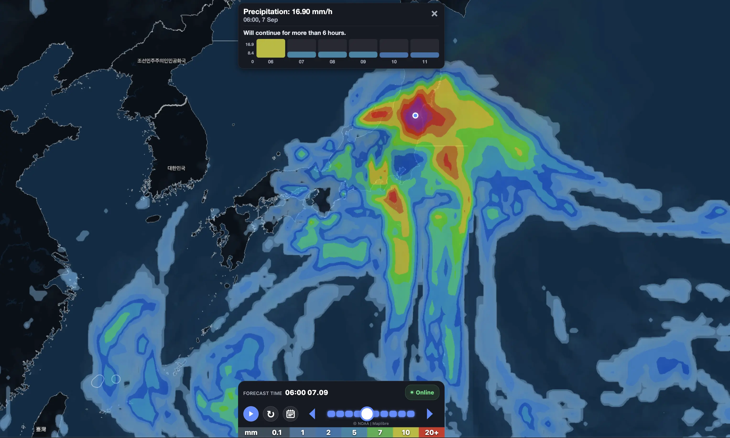
Kanto rain may intensify again tonight
Kanto had a relative lull during the daytime on September 8, but that improvement may be temporary.
Rain associated with the active Tokai system is expected to spread eastward.
JMA has issued advance information about the possibility of another linear precipitation band in Kanto-Koshin through early September 9.
Individual thunderstorms may be capable of more than 50 mm in one hour.
This matters especially because parts of Kanto are already saturated from the previous round of exceptional rain.
Izu Islands and southern Chiba remain extremely vulnerable
Even if the next rain band does not produce the highest totals there, the ground is already saturated.
By midnight at the start of September 8, observed 24-hour rainfall had reached approximately:
Niijima: 328.0 mm;
Oshima: 310.5 mm;
Katsuura, Chiba: 266.0 mm;
Tateyama, Chiba: 241.0 mm.
That means a smaller additional rainfall event can now trigger a much larger hydrological response.
Why linear precipitation bands are so dangerous
線状降水帯 is not simply another name for heavy rain.
It describes a narrow corridor where thunderstorms repeatedly develop and move across the same area.
One storm may last only 20–30 minutes.
But if five or six storms follow the same track, rainfall can accumulate catastrophically within only a few hours.
This is how locations can move from normal rainfall to:
100 mm in one hour;
150 mm in three hours;
rapid river flooding;
landslides with little warning;
roads becoming impassable.
Severe thunderstorms: lightning, hail and violent gusts
The danger is not limited to rainfall.
The atmosphere near the front is extremely humid and unstable.
JMA warns about:
frequent lightning;
hail;
severe wind gusts;
rapidly developing thunderstorms;
locally violent gusts associated with tornado-like rotation.
If a developed cumulonimbus cloud approaches and conditions suddenly become dark and windy, move inside a sturdy building.
Do not shelter beneath isolated trees.
Weather Forecaster: the strongest city signals through September 12
The latest Weather Forecaster forecast model also shows a broad multi-day heavy-rain pattern rather than one isolated wet day.
Location
Sep. 8
Sep. 9
Sep. 10
Sep. 11
5-day signal
Shizuoka
124 mm
91 mm
23 mm
53 mm
~311 mm
Nagoya
36 mm
73 mm
33 mm
46 mm
~225 mm
Kanazawa
28 mm
81 mm
9 mm
41 mm
~175 mm
Osaka
31 mm
39 mm
35 mm
28 mm
~154 mm
Tokyo
44 mm
34 mm
14 mm
30 mm
~127 mm
Yokohama
18 mm
49 mm
12 mm
17 mm
~98 mm
Kochi
18 mm
7 mm
25 mm
15 mm
~88 mm
Sendai
14 mm
40 mm
1 mm
19 mm
~73 mm
Chiba
6 mm
29 mm
7 mm
15 mm
~65 mm
MODEL SIGNAL vs OFFICIAL WARNING
Weather Forecaster values describe a model grid over individual cities.
Official JMA warnings must take priority during linear rain-band events because real thunderstorms can concentrate 50–100+ mm of rain inside a very narrow corridor that a city-grid forecast cannot resolve precisely.
Shizuoka remains one of the most concerning locations in the model.
Weather Forecaster currently gives:
September 8: about 124 mm;
September 9: about 91 mm;
September 10: about 23 mm;
September 11: around 53 mm;
September 12: around 20 mm.
That is more than 300 mm over five days in the current city-grid forecast.
For Shizuoka, repeated rainfall is particularly dangerous because of steep terrain and the high landslide sensitivity of mountain slopes.
Nagoya: heavy rain continues after today’s emergency
Today’s extreme rain does not necessarily end when the current linear rain band weakens.
Weather Forecaster still gives Nagoya approximately:
36 mm September 8;
73 mm September 9;
33 mm September 10;
46 mm September 11;
37 mm September 12.
The model also gives gusts near 53 km/h on September 9.
After more than 100 mm per hour has already occurred locally in Aichi, any additional rain becomes more dangerous because drainage systems, rivers and slopes are already stressed.
Tokyo: renewed rain rather than an “all clear”
The Tokyo story has also changed again.
Central Tokyo is not currently showing another 300 mm model day.
Instead, Weather Forecaster now shows a prolonged wet period:
September 8: about 44 mm;
September 9: about 34 mm;
September 10: around 14 mm;
September 11: around 30 mm.
Peak model gusts on September 9 reach roughly 53 km/h.
This is a lower daily total than earlier extreme model runs, but it is still important because Kanto soils and rivers have already been affected by several days of heavy rainfall.
Yokohama and Chiba
Yokohama’s current model peak comes on September 9 with around 49 mm.
Chiba has around 29 mm on September 9.
But Chiba’s model number should not be interpreted as low risk.
Southern Chiba has already experienced 24-hour observed rainfall exceeding 240–260 mm in some locations, so landslide and river risk can remain high even when the next forecast total is smaller.
The Founder and Chief Meteorologist at Pogodnik.com. With over 15 years of operational experience in synoptic analysis and climate forecasting, he specializes in storm tracking, magnetic storms, and atmospheric dynamics. A recognized expert in Ukraine’s meteorological sector, he maintains strategic collaborations with global agencies, including NOAA and ECMWF, to ensure high-precision data integration. His analytical reviews and scientific contributions are regularly featured in leading media outlets dedicated to weather science and environmental trends.