Super Typhoon Kong-rey Bring Record Rains to China and Threaten Japan with Flooding and Landslides

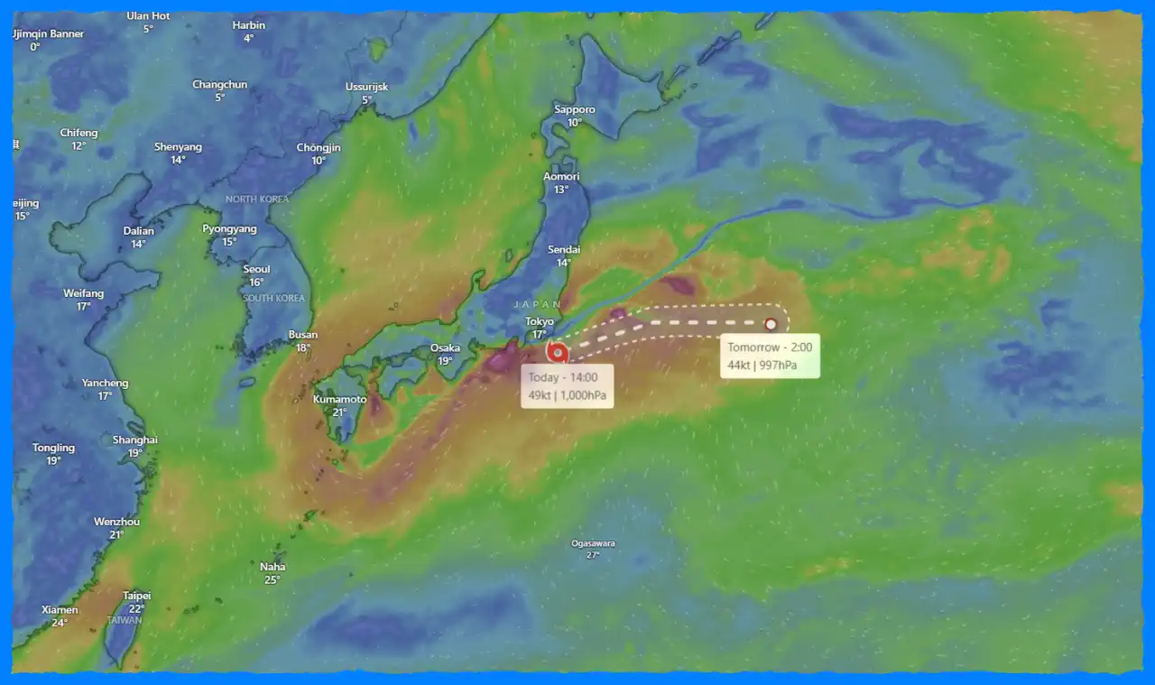
The remnants of former Super Typhoon “Kong-rey” are wreaking havoc across East Asia, particularly in China and Japan. After making landfall in Taiwan, where it left a tragic toll of three fatalities and over 500 injuries, Kong-rey has since transformed into an extratropical low, continuing its destructive path. As it moves away from Taiwan, it has now begun to heavily impact coastal regions of China and poses significant risks of landslides and flooding in Japan.
Devastation in Taiwan
Super Typhoon Kong-rey peaked as a Category 4-equivalent storm, reaching sustained winds of 240 km/h (150 mph) before making landfall in Taiwan on October 31. The storm brought torrential rains, with Hualien recording an astonishing 119.5 mm (4.70 inches) in just one hour and over 300 mm (12 inches) within a 24-hour period. The aftermath left three people dead, with four others missing and hundreds injured. Additionally, the storm triggered widespread power outages, affecting over 843,000 households, and left many without water.
Impact on Coastal China
As Kong-rey transitioned into its extratropical phase, it brought severe weather to eastern coastal provinces of China, particularly Zhejiang and Fujian. On November 1, over 80 weather stations in Zhejiang reported record-breaking rainfall for the month of November, with Linhai station measuring an unprecedented 216.3 mm (8.5 inches). This volume shattered previous monthly records set in 1997. Similarly, Shanghai experienced its heaviest November rainfall on record, accumulating 252 mm (9.9 inches) of rain in a single day.
The storm not only caused record precipitation but also resulted in extensive disruptions, including flooding in urban areas and damage to infrastructure. In Hallasan, South Korea’s Jeju Island, a staggering 268.5 mm (10.57 inches) of rain was reported on November 1, causing significant flooding and damage to buildings across the island.
Anticipated Impact on Japan
With the storm’s remnants now heading toward Japan, the Japan Meteorological Agency (JMA) has issued warnings for potential rain-related disasters. Western Japan, particularly northern Kyushu, is expected to receive up to 250 mm (9.84 inches) of rainfall from November 1 to November 2. The situation could be even more severe from November 2 to 3, as the storm influences weather patterns across eastern regions, including the Tohoku area, where similar levels of rain are anticipated.
Authorities are on high alert as the heavy rain increases the risk of landslides and flooding in low-lying areas. The JMA warns residents of these impending conditions and advises them to prepare for possible evacuations and emergency measures.
Conclusion
The impact of Super Typhoon Kong-rey serves as a stark reminder of the increasing volatility of weather patterns in the region. As the remnants continue to move through East Asia, the risks associated with heavy rainfall and the potential for natural disasters remain a significant concern. Local authorities and residents must remain vigilant and prepared as they face the aftermath of this powerful storm and its continued effects on the region.
Gleb Perov is the founder and chief meteorologist of POGODNIK, a leading weather forecasting service in Eastern Europe. With over 15 years of hands-on experience in meteorology and climate analysis, he has worked private weather services.
Gleb is the author of numerous scientific and analytical publications on climate, magnetic storms, and atmospheric processes. He regularly collaborates with major international agencies such as NOAA, ECMWF.


