Winter storm cripples Iowa and Indiana as snow, ice and extreme cold trigger major highway shutdowns
What happened: rapid snowfall and near-zero visibility
A fast-moving but intense winter storm system moved across the central United States in mid-December, impacting large portions of Iowa before advancing east into Indiana. Snowfall intensified rapidly, covering interstates and secondary roads with packed snow and ice, while strong, gusty winds reduced visibility to near zero in open and rural areas.
As temperatures dropped well below freezing, untreated road surfaces became increasingly slick. The combination of snow, ice and blowing snow created whiteout conditions at times, making travel extremely hazardous even on major highways.

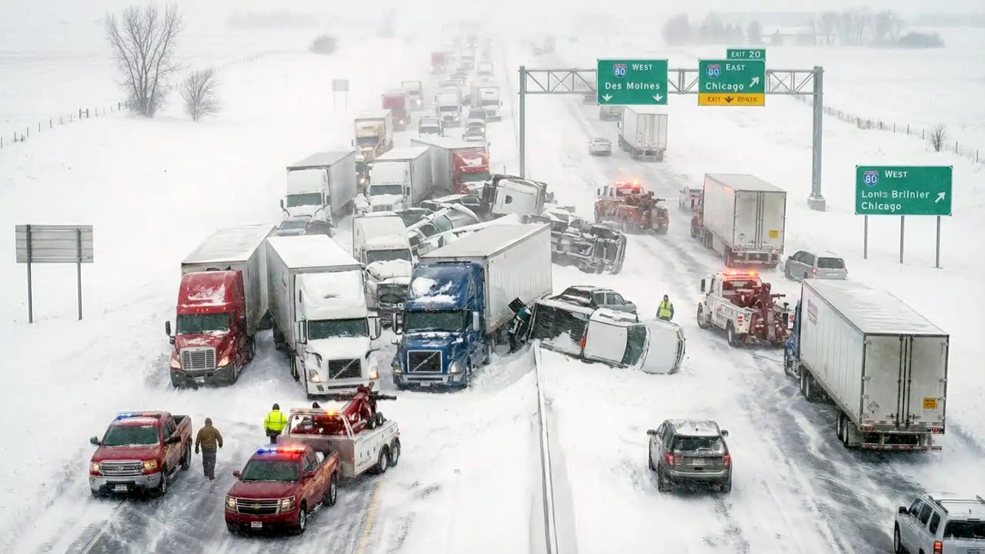
Interstate 80 paralyzed by massive pileups
Interstate 80 emerged as one of the most severely affected routes, particularly across eastern Iowa and into parts of Indiana. Authorities reported multiple large-scale, multi-vehicle crashes involving passenger cars and commercial trucks. In several locations, traffic came to a complete standstill for hours as emergency crews struggled to reach crash sites through snow-covered lanes.
Both eastbound and westbound lanes of I-80 were shut down repeatedly as wreckage blocked the roadway and conditions became too dangerous for continued travel. Vehicles were left immobilized on the interstate, with some drivers forced to wait for hours in freezing temperatures as snow continued to fall and winds drove additional drifting across cleared sections.
Emergency response stretched thin
Emergency responders faced significant challenges navigating congested and icy roads while assisting injured motorists and coordinating vehicle removals. Snowplows and road crews worked continuously, but persistent snowfall and blowing snow repeatedly erased progress, quickly covering freshly cleared lanes.
Law enforcement agencies across Iowa reported numerous slide-offs and minor crashes throughout the storm period, especially in rural areas where drifting snow further reduced traction and visibility. Travel advisories were issued, and authorities repeatedly urged residents to stay off the roads unless absolutely necessary.
Indiana sees similar impacts as storm shifts east
As the storm advanced eastward, central and northern Indiana experienced similar conditions. Persistent snowfall combined with icy bridges and overpasses led to a sharp increase in weather-related crashes. Urban and suburban roads became slick within hours, complicating commutes and emergency operations.
Snowplow crews worked around the clock to keep major routes passable, but falling temperatures made road treatment difficult. Refreezing overnight conditions frequently undid daytime improvements, keeping travel risks elevated well into the following days.
Broader impacts beyond transportation
The storm disrupted daily life across both states. Schools and public services faced delays or temporary closures, while residents were advised to limit outdoor exposure due to the extreme cold and wind chill. Power systems were closely monitored as freezing temperatures drove up energy demand, raising concerns about localized outages.
Communities responded by checking on vulnerable residents, assisting neighbors with snow removal and preparing emergency shelters in case prolonged outages or stranded motorists required additional support.
Why conditions remained dangerous for days
Meteorologists noted that the storm was embedded in a broader winter pattern, with Arctic air firmly in place across the central United States. Even after the heaviest snowfall eased, additional snow showers, gusty winds and dangerously cold air persisted, keeping road surfaces icy and visibility reduced.
Overnight refreezing repeatedly transformed slushy or wet surfaces into hard ice, increasing the risk of accidents during early morning and nighttime travel. Officials warned that roads could appear clear while remaining deceptively slick, particularly on bridges, overpasses and shaded sections.
Short-term forecast and outlook
Forecasters warned that hazardous conditions would continue until the storm system fully cleared the region and temperatures began to stabilize. While snowfall intensity was expected to gradually decrease after December 15, cold air lingering over Iowa and Indiana meant that ice and compacted snow would remain a concern.
Authorities continued to urge patience and preparedness, emphasizing the importance of carrying emergency supplies such as warm clothing, food, water and fully charged mobile devices when travel could not be avoided. With cleanup and recovery efforts ongoing, residents were advised to monitor official weather updates closely and prioritize safety over convenience.

Gleb Perov is the founder and chief meteorologist of POGODNIK, a leading weather forecasting service in Eastern Europe. With over 15 years of hands-on experience in meteorology and climate analysis, he has worked private weather services.
Gleb is the author of numerous scientific and analytical publications on climate, magnetic storms, and atmospheric processes. He regularly collaborates with major international agencies such as NOAA, ECMWF.


