Europe Is Not Done With Extreme Weather: New Forecasts Raise Heat, Fire and Autumn Flood Risks
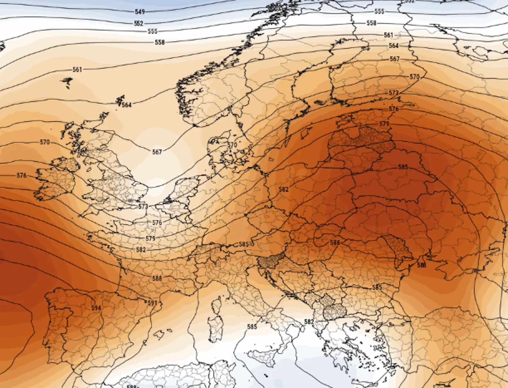
Europe’s most dangerous weather story of 2026 may not be the heatwave that has already happened. New long-range forecasts suggest that the same background pattern responsible for drought, wildfires and repeated bursts of extreme heat could persist into August before giving way to a very different threat: violent thunderstorms, flash floods and a potentially stormier start to autumn.
The central forecast is not for every part of Europe to remain exceptionally hot, dry or stormy at the same time. Seasonal models cannot predict individual heatwaves, floods or windstorms months in advance. What they can identify is the background environment that makes those events more or less likely.
The latest signal points to an unusually warm late summer across much of the continent, continued drought stress in several regions and a heightened fire-weather threat around the Mediterranean and parts of central and eastern Europe. The most pessimistic plausible scenario would combine another major heat dome in August with worsening water shortages, widespread wildfires and, later, a sharp transition to high-impact storms.
That worst-case chain of events is possible, but it is not the primary forecast. Its estimated probability remains substantially lower than the probability of a more moderate continuation of above-normal temperatures.
What the latest European forecast signals
Above-normal temperatures remain the leading scenario for much of Europe through August.
Another widespread and intense heatwave is possible, but not guaranteed.
Drought and wildfire danger are already elevated and could worsen where substantial rain fails to arrive.
Central Europe faces a dangerous combination of heat, dry ground and locally severe thunderstorms.
The risk of wetter and stormier weather gradually increases in western and northern Europe during autumn.
Early cold outbreaks are possible later in autumn, especially in eastern Europe, but confidence is currently low.
The forecast in one table
Weather risk
Most likely scenario
Most pessimistic plausible scenario
Estimated probability of pessimistic scenario
Late-summer heat
Temperatures remain above normal across large parts of Europe, with several shorter regional heatwaves.
A persistent heat dome produces another extensive heatwave, with temperatures locally reaching or exceeding 40°C in southern and southeastern Europe and challenging local records farther north.
35–45%
Drought
Existing drought continues in parts of western, central, southern and eastern Europe, with only uneven relief from thunderstorms.
A dry August sharply reduces river flow and soil moisture, expanding agricultural losses and water restrictions.
40–55%
Wildfires
Periods of high or very high fire danger persist around the Mediterranean and in other drought-affected areas.
Several simultaneous large fires overwhelm regional resources, threaten communities and cause long-range smoke transport.
25–35%
Severe thunderstorms
Storm outbreaks develop along the edges of hot air masses, especially across France, the Alps, Germany, Poland, Czechia, Austria, northern Italy and the Balkans.
A major heat breakdown triggers destructive wind, very large hail, flash flooding and isolated tornadoes across multiple countries.
25–40%
Autumn rainfall and floods
Atlantic systems become more influential from September into October, bringing more frequent rain to western and northern Europe.
Slow-moving lows and moisture-rich Mediterranean systems produce repeated flooding in western, central or southern Europe.
25–35%
Early autumn cold
Brief cooler spells interrupt an otherwise mild early autumn.
A strongly amplified pattern sends an unusually early cold outbreak into eastern or central Europe, bringing early frost or mountain snow.
15–25%
Important: These percentages are calibrated risk estimates based on the strength, persistence and agreement of current ensemble signals. They are not official probabilities of a specific disaster occurring in a particular city. A 30% probability of an extreme regional scenario still means that the less severe outcome remains more likely.
Why the European outlook has become more dangerous
Europe entered the second half of July with several hazards already active at once. Extreme heat had intensified drought, lowered river levels, damaged crops and increased wildfire danger. When cooler air finally reached some regions, the relief was accompanied by destructive thunderstorms, lightning and damaging wind.
This sequence matters because the ground and vegetation retain the impact of previous heat even after air temperatures fall. A few days of rain may reduce immediate fire danger, but they do not automatically restore depleted soil moisture, reservoirs or major rivers.
The European Drought Observatory reported that conditions remained critical across much of Europe in late June and had worsened in central-western areas. Watch or warning conditions also persisted in parts of the Baltic region and the Iberian Peninsula despite limited local recovery.
The most important question is therefore not simply whether Europe will experience another heatwave. It is whether the next heatwave arrives before the continent has had enough sustained rain to reduce drought and fire vulnerability.
August 2026: heat remains the dominant risk
ECMWF seasonal guidance continues to support above-normal temperature probabilities across broad parts of Europe. This does not mean every week will be hot, nor does it guarantee another record-breaking event. It indicates that warm periods are likely to outweigh cooler interruptions when the month is averaged as a whole.
The main scenario for August is a fluctuating pattern: ridges of high pressure produce repeated heat across southern, central and eastern Europe, while Atlantic disturbances periodically bring cooler weather and thunderstorms into the west and northwest.
The most pessimistic plausible scenario is more persistent. In that version, high pressure rebuilds over western or central Europe and becomes slow-moving. Hot air from North Africa then expands northward through Spain and France, or northeastward through Italy, the Balkans and central Europe.
Under such a configuration, daytime temperatures could again exceed 40°C across parts of Spain, Portugal, Italy, Greece and the Balkans. France, Germany, the Benelux countries, southern Britain, Poland, Czechia, Austria and Hungary could experience shorter but intense heat spikes.
The estimated probability of a broad, persistent August heat-dome episode is around 35–45%. The probability of at least one significant regional heatwave is higher, approximately 65–75%.
Western Europe: heat, drought and water pressure
France and the Benelux countries
France remains one of Europe’s most exposed countries because high temperatures are interacting with drought, stressed agriculture and constraints on river-dependent energy and transport systems.
The most likely outcome is another warmer-than-normal period interrupted by thunderstorms and temporary Atlantic cooling. However, rain from thunderstorms is often highly uneven. One district may receive flash flooding while a nearby area remains nearly dry.
The pessimistic scenario would bring another prolonged heatwave, further pressure on water resources and renewed restrictions in the driest departments. If a cold front then breaks the heat, France, Belgium, Luxembourg and the Netherlands could face damaging thunderstorms.
Probability of this combined heat-and-severe-storm scenario: 30–40%.
United Kingdom and Ireland
The strongest heat is less likely to persist as long as it might farther south, because the Atlantic can reassert itself more quickly. Even so, blocking highs can still direct unusually warm air into Britain and Ireland.
The leading scenario is for alternating warm, dry spells and more changeable Atlantic weather. The higher-impact scenario would involve another unusually hot period, worsening local water shortages and grass-fire danger before thunderstorms arrive.
Probability of a notable renewed heat episode: 30–40%. Probability of prolonged record-level heat across most of the region: approximately 15–25%.
Southern Europe: the highest heat and wildfire exposure
Spain and Portugal
The Iberian Peninsula remains highly vulnerable to extreme temperatures, drought and fast-moving wildfires. Even where recent rain has provided partial relief, vegetation and deeper soil layers may remain dry.
The most likely scenario is continued above-normal heat with several periods of very high fire danger. The pessimistic scenario would involve repeated incursions of Saharan air, temperatures above 40°C and wind-driven fires occurring in more than one region at the same time.
Probability of an extreme multi-day Iberian heatwave in August: 40–50%. Probability of a major simultaneous-fire episode affecting several regions: 25–35%.
Italy, Greece and the Balkans
Southern Italy, Greece and the Balkans could become one of Europe’s main heat centres if high pressure shifts east. Warm seas would add moisture to the lower atmosphere, increasing nighttime heat stress and making conditions more dangerous for vulnerable populations.
In the higher-impact scenario, extreme heat is followed by dry thunderstorms, lightning ignitions and strong outflow winds. Later, slow-moving Mediterranean lows could bring torrential rain to terrain already damaged by fire.
Probability of severe regional heat: 45–60%. Probability of a combined heat, wildfire and subsequent flash-flood sequence in at least one Mediterranean country: 20–30%.
Central Europe: where heat could collide with severe storms
Germany, Switzerland, Austria, Czechia, Slovakia, Poland and Hungary may lie near the boundary between hot continental air and cooler Atlantic air. This transition zone is often where the most dangerous thunderstorms develop.
The base scenario is for several warm or hot periods, each interrupted by showers and thunderstorms. Most storms would remain local, but some could produce large hail, damaging wind and intense rainfall.
The pessimistic scenario would involve a strongly heated and humid air mass followed by an energetic upper-level trough. That setup could support organised severe thunderstorms or mesoscale convective systems crossing multiple countries.
Potential impacts would include destructive wind gusts, very large hail, widespread tree damage, railway disruption, power outages and flash flooding in urban areas.
Probability of at least one significant multi-country severe-weather outbreak before the end of August: 30–45%. Probability of a truly exceptional, widespread outbreak: 10–20%.
Eastern Europe and Ukraine: prolonged warmth with an uncertain storm track
Eastern Europe is likely to remain warmer than normal overall, although the precise placement of blocking highs and storm tracks is uncertain.
The most likely scenario brings recurring heat to Romania, Moldova, Ukraine and neighbouring areas, interrupted by local fronts and thunderstorms. Rainfall distribution is likely to remain uneven, leaving some agricultural areas exposed to worsening soil-moisture deficits.
The pessimistic scenario would involve a persistent ridge extending from the Balkans toward eastern Europe. That could produce prolonged heat, drought stress and elevated fire danger, especially where spring and early-summer rainfall was insufficient.
Probability of a significant August heat episode in southeastern and eastern Europe: 50–65%. Probability of a long-lived extreme heat dome affecting a broad part of the region: 25–35%.
Northern Europe and Scandinavia: lower heat risk does not mean low risk
Northern Europe is less likely to experience the prolonged extreme heat expected farther south, but blocking can occasionally push unusually warm air into Scandinavia and the Baltic region.
Long daylight, dry vegetation and warm anomalies can quickly elevate forest-fire danger. Lightning from isolated storms may also ignite fires far from populated areas.
The leading scenario is variable weather with both warm ridges and cooler Atlantic or Arctic interruptions. The pessimistic scenario would bring a persistent Scandinavian block, regional drought and a notable increase in forest fires.
Probability of a prolonged Scandinavian or Baltic warm block: 25–35%. Probability of a widespread exceptional heat event: 10–20%.
Wildfire forecast: the danger may peak before the heat does
Wildfire risk is not controlled by temperature alone. Wind, humidity, fuel dryness, lightning and the number of simultaneous ignitions determine whether a fire remains manageable or becomes a regional emergency.
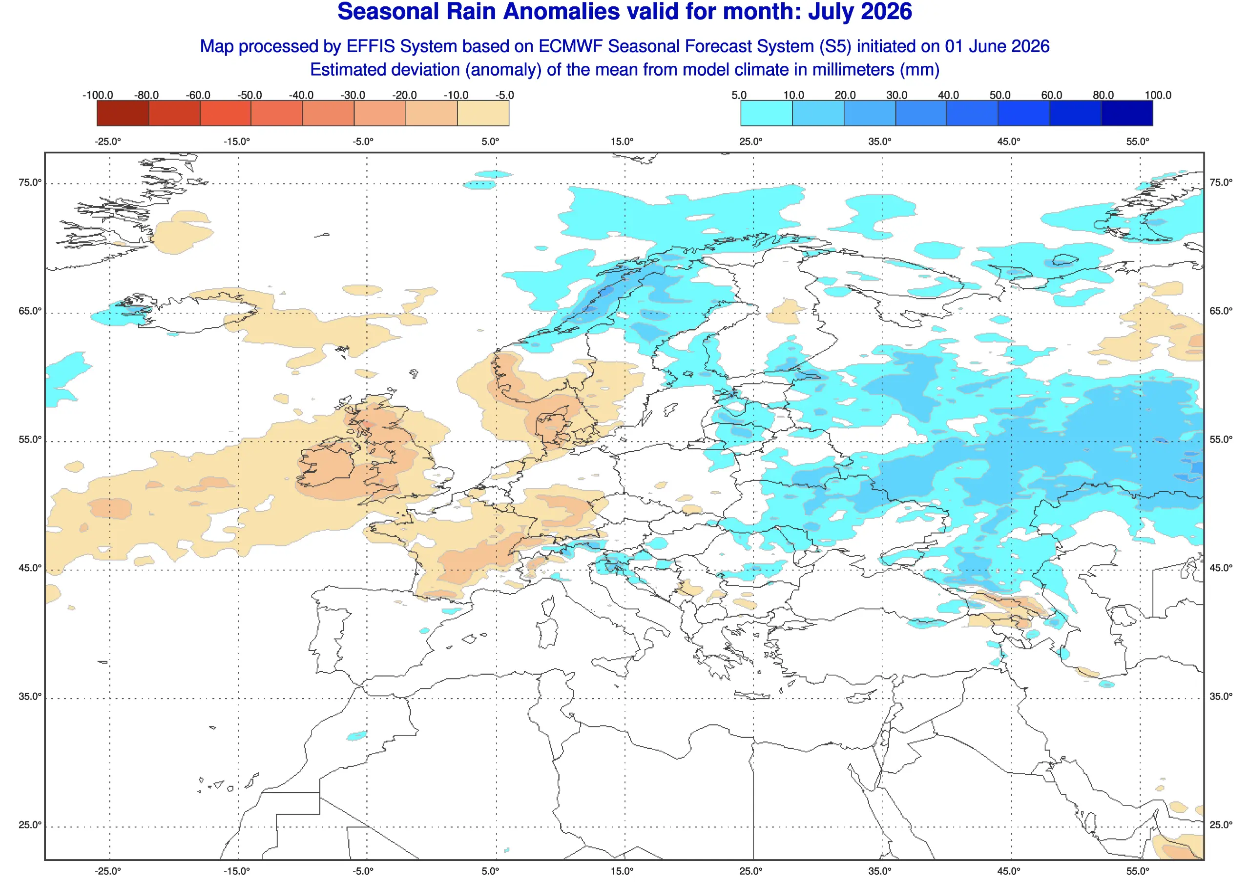
Copernicus EFFIS seasonal products provide long-range temperature and rainfall anomaly guidance for European fire-weather assessment. Existing drought means that even a brief return of strong wind and extreme heat could quickly produce critical conditions.
The most likely wildfire pattern is a series of regional emergencies around the Mediterranean rather than one continuous continent-wide crisis.
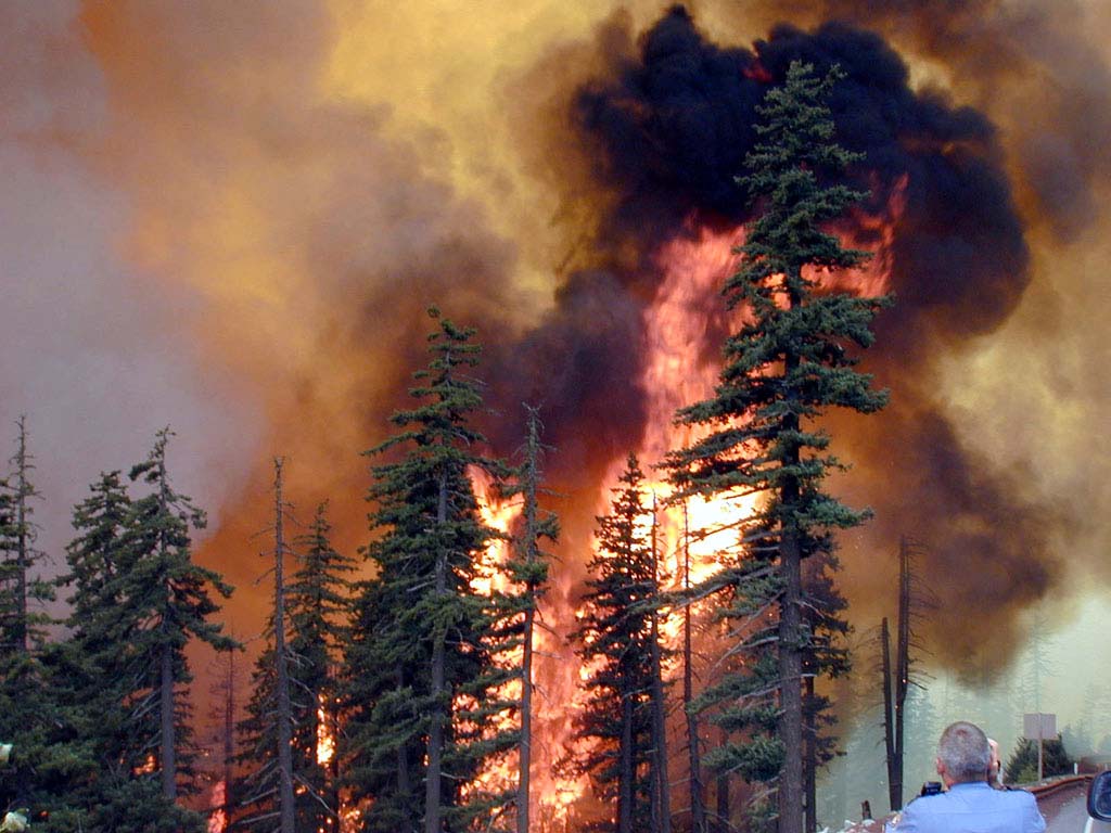
The most dangerous scenario would involve large fires burning simultaneously in Spain, Portugal, southern France, Italy, Greece or the Balkans. Competition for aircraft and specialist crews could then become as important as the weather itself.
Estimated probability of at least one major European wildfire emergency during the remainder of summer: 60–75%. Probability of simultaneous high-impact fire emergencies in several countries: 25–35%.
September 2026: summer heat may not end on schedule
September is the first major transition point. Seasonal warmth can persist well into the month, particularly across the Mediterranean and eastern Europe, while Atlantic systems begin to become more active farther west.
The main scenario is a delayed transition: warm conditions remain dominant across southern and central Europe, but rain and wind become more frequent in the northwest.
The pessimistic scenario would feature a final major heat surge followed by a rapid pattern breakdown. Very warm Mediterranean waters could add moisture to developing storms, increasing the risk of excessive rainfall.
Probability of an unusually warm September across much of Europe: 55–70%. Probability of a major late-season heatwave affecting several countries: 25–35%.
October and November: the flood and windstorm risk rises
Forecast confidence decreases significantly by October and November. Nevertheless, several broad risks can already be identified.
If Atlantic circulation strengthens, western and northern Europe would face more frequent low-pressure systems, rain and strong wind. If blocking remains farther east, the storm track could repeatedly target the same regions.
Southern Europe faces a different hazard. Warm Mediterranean waters can provide additional moisture to slow-moving depressions, increasing the potential for torrential rain and flash flooding in Spain, southern France, Italy, the Adriatic region and Greece.
The main autumn scenario is for an uneven transition, with wetter periods in western and northern Europe and continued warmth farther south and east.
The pessimistic scenario would be a sequence of Atlantic windstorms or Mediterranean flood events rather than one single Europe-wide disaster.
Probability of a notably active autumn storm period in western or northern Europe: 30–40%. Probability of at least one major Mediterranean flood episode: 35–50%. Probability of an exceptional continent-wide storm season is lower, approximately 10–20%.
Could Europe face an early cold outbreak?
A warm seasonal forecast does not eliminate the possibility of an early cold spell. Strong blocking near Greenland, Scandinavia or western Russia can briefly pull Arctic air southward even during an otherwise mild autumn.
The most likely outcome is for early autumn to remain predominantly mild, with short cooler interruptions.
The more pessimistic agricultural scenario would involve an abrupt cold outbreak in October or November, bringing early frost to eastern and central Europe after an extended warm growing season.
At present, the probability of an unusually early and widespread cold outbreak is only 15–25%. It should be monitored, but it should not be presented as the primary autumn forecast.
What could invalidate this forecast?
Seasonal forecasts describe probabilities, not a fixed sequence of weather events. Several developments could significantly change the outcome.
A more active Atlantic storm track could bring earlier drought relief to western and central Europe.
A persistent Scandinavian block could redirect both heat and rainfall into different regions.
Repeated cut-off lows could produce local floods even during an otherwise dry month.
Changes in tropical Pacific and Atlantic circulation may alter the European jet stream later in autumn.
Small shifts in the position of a ridge or trough can determine whether one country receives extreme heat while another receives severe storms.
How this forecast was preparedThis analysis combines ECMWF SEAS5 seasonal temperature and rainfall probabilities, ECMWF sub-seasonal guidance, Copernicus European Drought Observatory indicators, Copernicus EFFIS fire-weather products and the observed state of Europe in July 2026.
The probability ranges are an editorial synthesis of ensemble agreement, current land conditions, seasonal predictability and known regional exposure. They do not replace national weather-service warnings.
What residents and travellers should watch
Heat: nighttime minimum temperatures can be as dangerous as daytime peaks, especially in large cities.
Wildfires: follow evacuation orders immediately and avoid routes crossing active fire zones.
Thunderstorms: damaging wind and hail may develop before heavy rain reaches a location.
Flash floods: never drive through floodwater, particularly in mountain valleys and Mediterranean coastal areas.
Travel: check national warnings shortly before departure because seasonal outlooks cannot identify local storm timing.
Europe’s most likely late-summer outcome is continued abnormal warmth, recurring regional heatwaves and persistent drought or wildfire stress in the most vulnerable areas.
The most pessimistic credible scenario is more complex: another major heat dome intensifies drought and fire danger in August, then collapses into destructive thunderstorms before a stormier autumn raises the risk of floods and damaging wind.
That full chain of extremes is not the primary forecast. Its estimated probability is around 20–30%. But individual parts of it—especially renewed heat, major wildfires or regional flash flooding—are considerably more likely.
The open question for Europe is therefore no longer whether the weather will remain unusual. It is which hazard comes next, and whether drought-stricken regions receive useful rain or only another round of damaging storms.
Track changing weather conditions with PogodnikUse the Pogodnik weather app to follow local temperature forecasts, rain, thunderstorms, wind and severe-weather changes. During wildfire season, also check official national warnings and the Copernicus European Forest Fire Information System before travelling.
The Founder and Chief Meteorologist at Pogodnik.com. With over 15 years of operational experience in synoptic analysis and climate forecasting, he specializes in storm tracking, magnetic storms, and atmospheric dynamics. A recognized expert in Ukraine’s meteorological sector, he maintains strategic collaborations with global agencies, including NOAA and ECMWF, to ensure high-precision data integration. His analytical reviews and scientific contributions are regularly featured in leading media outlets dedicated to weather science and environmental trends.