Weather in Europe in December 2025: Long-Range Forecast, Snow Risks and Christmas Outlook
December 2025 in Europe is shaping up to be a month of contrasts: after a strong late-November snow outbreak, circulation turns milder and stormier at the start of December, while the second half of the month increasingly favours colder air outbreaks and more active snowfall – especially across Scandinavia, the Alps, the Carpathians and parts of Central and Eastern Europe.
Quick summary for December 2025
Where it will be coldest:
Northern and inland Scandinavia, Finland, northern European Russia (Karelia, Murmansk), the north-eastern Baltic region.
Mountain regions: Norwegian mountains, the Alps, the Carpathians, the Pyrenees, the Dinaric Alps and parts of the Balkans.
Where the most snow is expected:
Reliable snow: the mountains (Alps, Pyrenees, Carpathians, Norwegian mountains, Tatras, Scandinavia). Early-season snow depth in Austrian, Swiss and French resorts is already increasing quickly, and by Christmas a stable snowpack is likely.
Frequent snowfalls (but not guaranteed “storybook winter” in the lowlands): southern Scandinavia, the Baltic states, Poland, Czechia, Slovakia, Austria, southern and eastern Germany, inland Balkans, western Ukraine and Romania.
Rare snow, mainly wet or short-lived: lowlands of France, Benelux, the British Isles, lowland Poland and northern Italy.
Mostly rain: coastal Spain and Portugal, lowland Italy (except parts of the Po Valley during cold outbreaks), Greece, Turkey and the Adriatic coasts.
Winter background: La Niña, the polar vortex and early stratospheric warming
La Niña
In the tropical Pacific a La Niña pattern is currently in place: sea surface temperatures are below normal in the central and eastern basin, and NOAA expects the cold phase to persist at least through December–February 2025/26, fading towards neutral in spring.
For Europe this usually means a more active Atlantic storm track, especially in the first half of winter. When the polar vortex is weakened, the risk of blocking patterns and cold outbreaks into Europe increases.
Polar vortex and stratospheric warming
In November there was a very early episode of stratospheric warming (SSW): a strong high-pressure anomaly formed in the stratosphere over the Arctic, compressing and deforming the polar vortex. Forecasts showed strongly reduced westerly winds and even a possible reversal to easterlies – a rare event for November.
Such events reduce the vortex’s ability to “lock” cold air in the far north. Around 1–3 weeks after an SSW, the probability of Arctic air being pushed into the mid-latitudes rises, including into Europe.
What ECMWF is signalling for Europe
For December, ECMWF seasonal maps and independent diagnostics show a pressure anomaly with higher pressure towards northern Europe and lower pressure across central/southern Europe. This is a typical signal of blocking circulation (Scandinavian/Arctic blocks), which can redirect the flow to a more northerly or north-easterly component and bring cold continental air into Central Europe.
The temperature anomaly for December leans towards near or slightly below normal in western and central Europe, closer to normal or slightly above in the south. Snow-cover products suggest quite extensive snow cover in total for the month across large parts of Europe.
Bottom line:La Niña = active Atlantic, but a weakened polar vortex plus blocking highs open the door for periodic cold shots that can cut through the mild westerlies.
Meteoalarm and near-term snow alerts
In late November, Meteoalarm already showed a red warning level for snow and ice in Germany (24 November) – confirmed by ERCC reports and local warnings around Munich, where conditions significantly disrupted airport operations.
National services within Meteoalarm (ZAMG in Austria, AEMET in Spain, DHMZ in Croatia and others) have recently issued yellow/orange warnings for snow and ice in:
The Alps and surrounding foothills in Austria, Switzerland, northern Italy and Slovenia – snow and ice on passes and in some valleys.
Northern Spain / Pyrenees – snow in the mountains, with significant new accumulations in places.
Southern Norway and Sweden – intense precipitation: rain on the coast, heavy snow inland and at elevation.
Given the currently very active Atlantic pattern, during the first 7–10 days of December Meteoalarm is likely to show yellow/orange alerts for snow/ice most frequently across the Alps, Pyrenees, Scandinavia and parts of Central Europe, while coastal regions see more alerts for wind and heavy rain.
Week-by-week outlook: Europe in December 2025
Week 1 (1–7 December): mild and stormy start
Based on fresh ECMWF/ICON output and expert overviews:
Over the North Atlantic, very deep low-pressure systems develop, with central pressure dropping below ~950 hPa south of Greenland; to the south, a strong Azores High remains in place.
Across Western and Central Europe this creates a zonal south-westerly flow, with a powerful jet stream overhead.
Temperatures over large parts of Europe run 5–10 °C above average, especially in western and central areas.
Precipitation and snow:
Ireland, the UK, western France, northern Spain, Portugal – very wet, multi-day rainfall episodes with local flooding. Snow mainly restricted to the Scottish Highlands and the highest parts of Wales.
Norway (south and west) – heavy precipitation: rain along the coasts, significant snow in the mountains and inland.
Alps and Pyrenees – recurring snowfalls above roughly 1000–1500 m, steadily increasing snow depth at ski resorts.
Over the lowlands of Central and Eastern Europe (Germany, Poland, Czechia, Slovakia, Hungary, Ukraine) – mostly rain and fog, with brief episodes of wet snow at night.
Conclusion: despite the fresh snow from late November, the first 7–10 days of December look “anti-winter” in the lowlands: windy and rainy, with snow mostly in the mountains and far north.
Week 2 (8–14 December): prolonged Atlantic regime
Forty-five-day trend products for Germany and similar outlooks for France show a continuation of wet, relatively mild weather, with frequent fronts and a lack of prolonged frost at low elevations.
Europe as a whole remains under a train of Atlantic lows.
There is a chance of a short-lived colder incursion to the north and east (Scandinavia, Baltic region, northern Poland), bringing temporary snow down to low levels there.
Where snow is likely:
Scandinavia, Finland, northern European Russia – stable snow cover continues to build and expand.
Alps, Carpathians, Pyrenees, Balkans – successive snowstorms at elevation; the ski season enters full swing.
In the lowlands of Central Europe – some “stuck” frontal zones may bring 1–3 days with snow reaching the ground, but the chance of a long-lasting snow cover remains low.
Week 3 (15–21 December): chance of a shift towards blocking
Here, the influence of a weakened polar vortex and blocking highs over the north becomes more relevant:
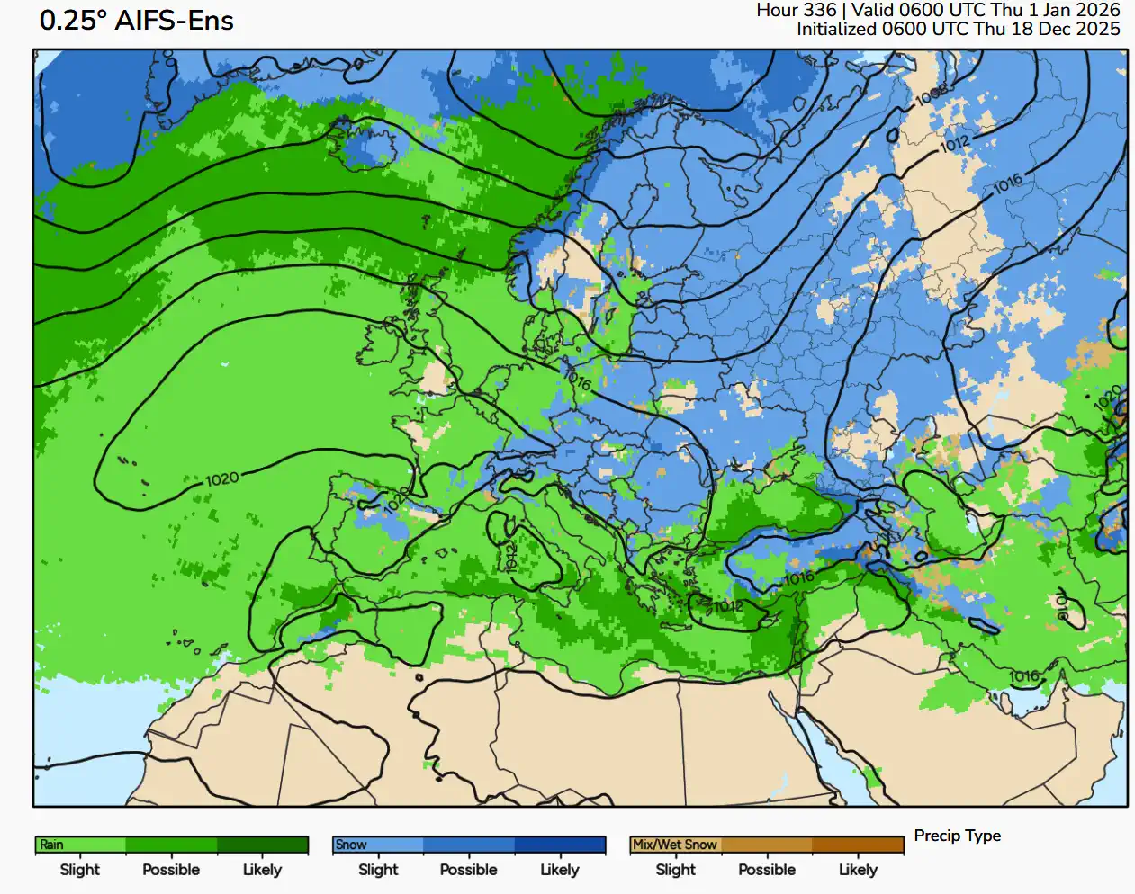
Seasonal ECMWF maps for December and multi-model WMO ensembles suggest higher pressure over northern Europe (Scandinavia, Barents region) and lower pressure further south. This pattern favours “Arctic arc” setups and more easterly or north-easterly flow into Central Europe.
Several long-range discussions (Severe-weather-style blogs, mkweather, Netweather forum and others) emphasise the scenario: very mild and stormy beginning of winter in December, with a possible sharp cool-down later in the month, though forecast confidence here is medium to low.
Scenario (probabilistic, not deterministic):
Scandinavia, Baltic region, northern Poland, Belarus, Ukraine, European Russia – increased probability of frequent cold outbreaks and regular snowfalls, in places with blizzard conditions.
Central Europe (Germany, Czechia, Slovakia, Austria, Poland): higher chance of several “true winter” episodes, when daytime temperatures stay below 0 °C and snow reaches the lowlands, but likely only for 2–4 days in a given week rather than all the time.
South-West Europe (Spain, Portugal, southern France, Italy, Balkans): multiple lows along a southern track – heavy rain and thunderstorms, with very heavy snow in the mountains.
Week 4 (22–31 December): Christmas–New Year “battle” between cold and Atlantic lows
By the end of the month, forecast spread is greatest:
ECMWF seasonal guidance and expert analyses suggest near-normal or slightly below-normal average temperatures for December and decent snow cover in total – which implies that if the colder scenario materialises, it may do so around Christmas and towards New Year.
However, some long-range outlooks still argue for an overall very mild start to winter, with the coldest anomalies delayed into January–February.
In practical terms:
Chance of a white Christmas in the lowlands of Western and Central Europe (Paris, London, Brussels, Amsterdam, Berlin) remains rather low but not zero – it would require one or two well-timed cold outbreaks.
Vienna, Prague, Warsaw, Budapest, Kraków – higher probability of postcard-style snow, especially in the second half of the month; still more like 40–60% rather than a guarantee.
Alps, Scandinavia, Carpathians, Pyrenees by this time are very likely to have deep, stable snowpacks, providing classic winter holiday conditions.
Top holiday locations: likely weather for Christmas and New Year
Important: a detailed day-by-day forecast for 24–31 December is still highly uncertain. But combining seasonal and 45-day guidance allows us to sketch likely tendencies.
Classic city breaks
London, Dublin, Amsterdam, Brussels
Scenario: daytime temperatures around +5…+10 °C, often windy and rainy, with a few cooler nights near 0 °C. Snow is more the exception than the rule – brief “flash” snow showers may accompany some cold fronts, but a persistent snow cover is unlikely.
Paris, Lyon
Very similar pattern: mostly rain, fog and damp weather, nights +1…+4 °C, days +5…+9 °C. Light snow is possible if a short cold spell occurs later in the month.
Berlin, Hamburg, Warsaw, Prague, Vienna
More continental: nights often 0…−3 °C, days +1…+4 °C, frequent light snow or wet snow, with a realistic chance of a temporary snow cover, especially at night and in the early morning.
If a Scandinavian blocking high sets up at the right time, a 3–5-day period of proper frosty and snowy weather around Christmas is quite possible here.
Ski and “snow-hunt” destinations
The Alps (Switzerland, Austria, France, northern Italy)
As of late November, snow reports already show deep early-season snow and rapidly expanding open terrain.
Fourteen- to 45-day snow projections for flagship resorts (Val Thorens, Chamonix, St. Anton, etc.) show several waves of snowstorms in the second and third weeks of December, building snow depth to 80–150 cm or more at higher elevations.
Scandinavia and Lapland (Rovaniemi, Kiruna)
Almost guaranteed sub-zero temperatures (−5…−20 °C), stable snowpack and polar night/very short days – textbook Arctic holiday settings.
Southern Europe
Barcelona, Rome, Athens, Lisbon
Typically mild and often wet: +10…+16 °C by day, +5…+10 °C at night, with showers and thunderstorms along the edges of passing lows.
Snow is mainly a mountain story: Pyrenees, Apennines, Pindus, Olympus and other ranges, occasionally reaching high foothills during the strongest Arctic outbreaks later in the month.
Where December 2025 is likely to be coldest and snowiest
Central and Eastern Europe: inland Poland, Czechia, Slovakia, Hungary, Romania, western and northern Ukraine, the Baltic states, European Russia.
Snow mainly in the mountains, rare in lowlands:
France (except the east and Alpine areas), Belgium, the Netherlands, Denmark.
Much of lowland Spain and Portugal.
Lowland Italy (except the Po Valley during occasional Arctic outbreaks).
Mostly rain and storms:
Mediterranean coasts (Spain, France, Italy, Greece, Turkey, Adriatic).
Main December theme here: heavy rain, thunderstorms, coastal storms – and huge snow totals in the mountains above.
What leading services say about December 2025 – and how reliable they are
ECMWF (seasonal and extended forecasts)
Shows blocking-type pressure anomalies over northern Europe and lower pressure to the south, which favours more north-easterly flow and near- to slightly below-normal December temperatures in many regions.
Snowfall products indicate plenty of potential for snow cover over central and northern Europe in monthly totals.
Skill: for winter monthly mean temperatures over Europe, ECMWF seasonal models have moderate to good skill (correlations roughly 0.6–0.7), but much lower skill for precipitation and individual snow events. Treat this guidance as a probability bias, not a precise, day-by-day forecast.
National and private services
Météo-France in its winter outlook (December–February) stresses the likelihood of a warmer-than-average season overall due to climate warming, while explicitly emphasising high circulation uncertainty – no clear single winner among NAO and blocking patterns.
DWD / wetter.de (Germany): 42-day trends highlight a cold spell at the end of November and start of December, followed by a prolonged wet, mild phase, with low probabilities for sustained snow at low elevations by Christmas.
UK Met Office long-range updates suggest predominantly mild, windy and wet conditions in December for the British Isles, with a limited chance of prolonged blocking and truly severe cold.
Private long-range outlooks:
mkweather, OnTheSnow and others characterise 2025/26 as a “winter of contrasts”: very mild and stormy start in December, with the strongest cold anomalies more likely in February.
WeathÉire and TheWeatherOutlook call 2025/26 a “wildcard winter” – model guidance leans towards mild/wet, but background dynamics (La Niña + a weakened polar vortex) keep the door open for meaningful cold episodes.
Overall consensus:
December is likely to start mild and stormy, but you cannot fully trust “mild all the way” scenarios for the second half of the month. Early stratospheric warming and a weakened polar vortex create a real window for cold snaps and active snowfalls, especially in Central and Eastern Europe.
Recent snow events in Europe (late-November context)
Finally, why did winter “switch on” so aggressively even before the calendar flipped to December?
In mid–late November, Europe was hit by an Arctic cold outbreak: a blocking high over Greenland and the North Atlantic disrupted the mild westerly flow and opened a direct corridor for Arctic air into Western and Central Europe.
Against this background, Europe experienced what some already call a “Late-November Snowfall Collapse” – a rapid spread of snowfalls:
Major snow across the Balkans, Hungary, Poland, Czechia, northern Spain, locally paralysing transport.
Red Meteoalarm level for snow and ice in Germany on 24 November, with major disruption at Munich Airport.
Alpine snow reports highlight deep November snow in Austria, Switzerland and France – many resorts opened earlier than usual with a solid base.
Snow and cold rain associated with vigorous Mediterranean lows and fronts affected Italy, Greece and parts of the Balkans.
These events are more than just a one-off episode – they are an important signal: the atmosphere has already reacted to the weakened polar vortex and La Niña background, showing that in the upcoming winter sharp cold “shots” are entirely realistic, even if monthly averages end up near normal.
🌦️ Overview: A Warm, Wet, and Restless November Ahead
The Founder and Chief Meteorologist at Pogodnik.com. With over 15 years of operational experience in synoptic analysis and climate forecasting, he specializes in storm tracking, magnetic storms, and atmospheric dynamics. A recognized expert in Ukraine’s meteorological sector, he maintains strategic collaborations with global agencies, including NOAA and ECMWF, to ensure high-precision data integration. His analytical reviews and scientific contributions are regularly featured in leading media outlets dedicated to weather science and environmental trends.