BREAKING: August 2025 Weather Forecast USA Canada – 50°F Start to 120°F Heat Index NIGHTMARE | NOAA Confirms Historic Pattern Reversal
As we enter the final month of meteorological summer 2025, North America stands at the crossroads of one of the most dramatic weather pattern reversals in recent memory. This August promises to be a tale of two completely different weather regimes – beginning with unseasonably cool conditions that will give way to a potentially record-breaking heat surge that could eclipse even this summer’s already historic temperature extremes.
Before diving into August’s forecast, we must first understand the unprecedented summer that has led us to this pivotal moment. The summer of 2025 has already etched itself into the annals of meteorological history, with a series of record-shattering heat events that have fundamentally altered our understanding of North American weather patterns.
Summer 2025: A Season of Broken Records
The meteorological fingerprints of climate change have been unmistakably evident throughout this summer. Boston hit 102 degrees on Tuesday, which was a new all-time June record for the city dating to 1872. Newark hit 103 degrees, tying its June record. These weren’t isolated incidents but part of a broader pattern that saw temperature records falling like dominoes across the continent.
The expansive heat dome brought temperatures above 90 degrees for more than 190 million Americans in the East, but it wasn’t just the high temperatures making people feel miserable. Humidity is soaring, with dew points rising into the 70s. The combination of extreme heat and oppressive humidity created dangerous conditions that about 265 million people forecast to experience 90- or 100-degree temperatures during the week ahead, including humidity levels that rival those in the Middle East.
The atmospheric dynamics driving these extreme conditions have been rooted in what meteorologists call an amplified jet stream pattern. Throughout June and July, a persistent low-pressure anomaly over Canada has created a feedback loop that has fundamentally altered North American weather patterns. This configuration has allowed Arctic air masses to plunge southward while simultaneously enabling dangerous heat domes to establish themselves over populated areas for extended periods.
The average number of heat waves the U.S. experiences today has doubled since the 1980s, and the length of the dangerous heat wave season has increased from about 40 days to roughly 70. The summer of 2024 was the hottest on record since countries began documenting their temperatures in the 1800s. Yet 2025 appears poised to challenge even those records, with The two-month span of March and April 2025 was the fifth hottest in 131 years of U.S. recordkeeping.
The Atmospheric Setup: Understanding the Jet Stream Amplification
The key to understanding both this summer’s extreme weather and August’s forecast lies in comprehending the jet stream’s behavior. A strong low-pressure area over Canada helped to amplify the jet stream over the northern United States and southern Canada. This amplification has created what meteorologists term a “Rex block” pattern – a configuration where high pressure ridges and low pressure troughs become locked in place, leading to persistent weather patterns.
The Rex block has been particularly pronounced this summer, with strong low-pressure area over Canada with an extension into the west-central United States. This pattern has acted like a massive atmospheric traffic jam, preventing normal weather system progression and locking extreme conditions in place for extended periods.
August 2025: The Great Pattern Reversal
As we transition into August, NOAA and NWS data indicate we’re about to witness one of the most dramatic atmospheric pattern reversals in recent meteorological history. The month will begin with a complete departure from summer’s typical heat, before swinging dramatically in the opposite direction.
Early August: An Unseasonable Cool Down
The first week of August will bring a shocking departure from typical summer weather. The temperature forecast for the same period shows colder-than-normal weather over much of the central and eastern United States and eastern Canada. This is due to the pressure pattern that allows the transport of cooler northerly air into the United States.
Current NWS extended forecast discussions confirm this unusual pattern. It generally remains the case that a rather expansive cool air mass will settle into the eastern U.S. for the first week of August. This cool air mass will be so pronounced that The morning temperatures in this period are forecast to stay in the 50s across the Midwest, and in the 60s across a large part of the central U.S., northern Plains, and the northeast.
These temperatures represent departures of 15-25 degrees below normal for early August across much of the eastern two-thirds of the United States. Cities like Chicago, which typically see morning lows in the upper 60s to low 70s in early August, could experience temperatures more reminiscent of mid-to-late September.
The meteorological driver behind this dramatic cooling is a powerful high-pressure ridge that will establish itself over southern Canada and the northern United States. This ridge will act as a conduit for modified Arctic air masses to spill southward, creating what amounts to a false start to autumn across large swaths of North America.
Mid-August: The Pressure Reversal Begins
The second week of August marks the beginning of what forecasters are calling the “great pressure reversal.” You can see an unusually strong low-pressure area over northern Canada and the polar regions. There is also an extension of the low-pressure area indicated over the northern United States, and a ridge rising over the east and up into eastern Canada.
This represents a fundamental shift in the atmospheric pattern that has dominated North America throughout the summer. The low-pressure system that has been anchored over Canada will intensify and migrate northward, while a compensating high-pressure ridge begins to build across the central and eastern United States.
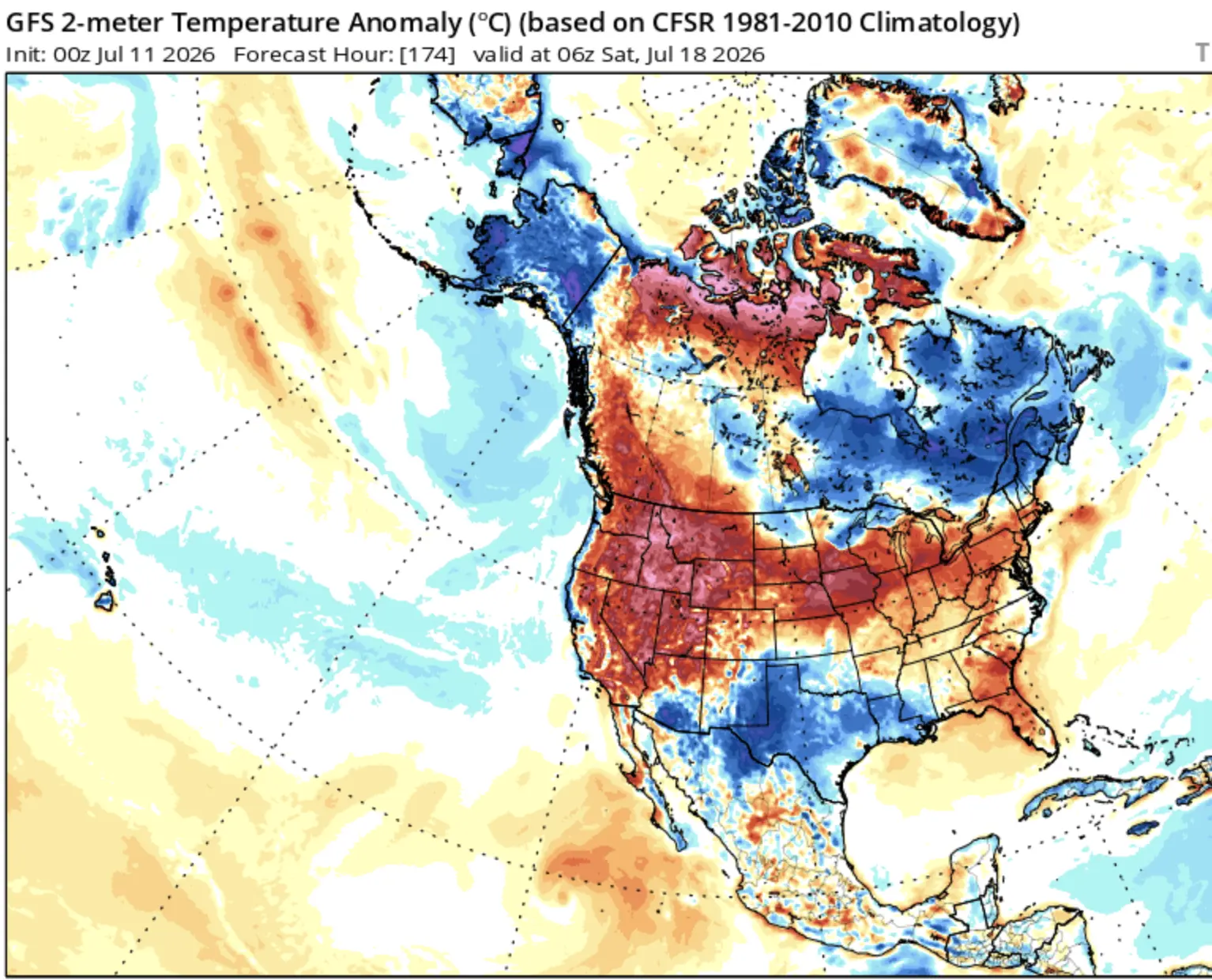
The temperature forecast below for the same period shows below-normal temperatures over the southeastern United States with a small pressure disturbance. But the rest of the United States and also southern Canada show above-normal temperatures as a new pressure pattern stabilizes.
This transition period will be marked by significant weather volatility. The competing pressure systems will create numerous opportunities for severe weather development, particularly across the central Plains and Midwest, where the boundary between the competing air masses will be most pronounced.
Late August: Return of Dangerous Heat
The final two weeks of August promise to bring a return of the dangerous heat that characterized much of this summer, but with potentially even greater intensity. The extended range forecasts show a pattern remarkably similar to the heat dome configurations that produced this summer’s record-breaking temperatures.
You can see the same warm anomaly spreading over the central and northern United States and southern Canada. But you can also see hints of normal to below-normal conditions over the eastern and southeastern United States. However, forecast models consistently underestimate extreme heat events in their extended range predictions, suggesting that actual temperatures could exceed current projections.
The atmospheric setup for late August shows all the hallmarks of a classic heat dome: a strong high-pressure system will establish itself over the central United States, while low pressure persists over eastern Canada. This configuration will pump hot, dry air northward from the desert Southwest while simultaneously drawing down hot, humid air from the Gulf of Mexico.
Unlike earlier summer heat events, this late-August pattern appears likely to be more persistent and potentially more dangerous. The high-pressure ridge is forecast to be stronger and more stable than previous heat dome configurations, suggesting that relief will be harder to come by once the pattern establishes itself.
Regional Impacts and Specific Forecasts
Great Lakes Region
The Great Lakes region will experience perhaps the most dramatic temperature swings of any area in North America during August. Early month temperatures could drop to levels not seen since late May, with morning lows potentially reaching the upper 40s in northern areas. However, the late-month heat surge could push temperatures into dangerous territory, with heat index values potentially exceeding 110°F across southern Michigan, northern Ohio, and southern Ontario.
Northeast Corridor
From Boston to Washington D.C., the Northeast will see a month of extremes. The early August cool spell will provide welcome relief from the record-breaking heat that plagued the region in June and July. However, the late-month pattern reversal could bring temperatures and humidity levels that rival or exceed the historic heat dome events of earlier this summer. Urban heat island effects in major metropolitan areas could push apparent temperatures above 115°F during the worst of the late-month heat.
Central Plains
The agricultural heartland will face particular challenges during August’s temperature swings. The early-month cooling, while providing relief from heat stress, could be accompanied by increased precipitation that may complicate harvest operations. The late-month heat surge poses significant risks to late-season crop development, particularly corn and soybeans in critical reproductive stages.
Western Canada
Western Canada will experience perhaps the most consistent pattern of the month, with above-normal temperatures prevailing throughout much of August. However, this doesn’t diminish the potential for extreme heat events, particularly in British Columbia’s Fraser Valley and Alberta’s prairie regions, where temperatures could challenge or exceed the catastrophic heat dome records set in 2021.
The Tropical Wild Card
August 2025’s weather story cannot be told without considering the Atlantic tropical season, which adds another layer of complexity to an already volatile forecast. ENSO-neutral is most likely through the late Northern Hemisphere summer 2025 (56% chance in August-October). Thereafter, chances of La Niña conditions increase into the fall and winter 2025-26, but remain comparable to ENSO-neutral
The current state of the tropical Atlantic presents a fascinating paradox. While traditional measures suggest a suppressed hurricane season, the atmospheric pattern changes forecast for August could create windows of opportunity for tropical development closer to the North American coastline.
The “Atlantic Niña” phenomenon – characterized by cooler-than-normal sea surface temperatures in the tropical Atlantic – has indeed suppressed traditional tropical wave activity coming off the African coast. However, the changing pressure patterns over North America could create favorable conditions for tropical cyclogenesis in the western Atlantic and Gulf of Mexico.
Of particular concern is the potential for rapid intensification events should tropical systems develop in the anomalously warm waters of the western Atlantic. These waters, superheated by this summer’s persistent heat domes, could fuel explosive tropical development should conditions align.
Climate Change Fingerprints
The extreme weather patterns forecast for August 2025 bear unmistakable signatures of anthropogenic climate change. The intensifying and expansive heat wave affecting around 150 million people in the United States from Wisconsin to Washington, DC, bears the hallmarks of human-caused global warming.
The amplified jet stream patterns that have characterized this summer and will continue into August represent a fundamental shift in atmospheric dynamics. As the Arctic continues to warm at a rate far exceeding that of lower latitudes, the temperature gradient that drives the jet stream weakens, leading to the meandering, persistent patterns we’ve observed.
This “Arctic amplification” effect has made extreme weather events more likely to persist for extended periods. Where once a heat dome might last 3-5 days before being displaced by changing weather patterns, we now see these systems maintaining their grip for weeks at a time, leading to the record-breaking heat events that have characterized 2025.
Societal and Economic Implications
The forecast patterns for August 2025 carry significant implications beyond mere meteorological interest. The early-month cooling, while providing relief from summer heat, could catch infrastructure systems off-guard. Energy grids prepared for peak summer demand may need to adjust rapidly to changing consumption patterns.
More concerning is the late-month heat surge potential. With many regions already stressed by earlier summer heat events, the additional strain of potentially record-breaking August heat could push critical infrastructure past breaking points. This is particularly true for urban areas, where the combination of heat island effects and aging infrastructure creates vulnerability to cascading failures.
Agricultural impacts will be severe and varied. The early-month cooling, while providing temporary relief from heat stress, could disrupt critical growing degree day accumulations for temperature-sensitive crops. Conversely, the late-month heat surge comes at a critical time for crop maturation, potentially leading to yield reductions and quality issues.
Public Health Considerations
The health implications of August’s forecast cannot be overstated. The rapid transition from unseasonably cool to potentially record-breaking heat creates unique challenges for human physiological adaptation. Populations that benefit from the early-month cooling may be particularly vulnerable when extreme heat returns, as the body’s heat adaptation mechanisms may have relaxed during the cooler period.
Urban areas face compounded risks. The heat island effect, which can add 5-10 degrees to already dangerous temperatures, combined with high humidity levels, could create life-threatening conditions for vulnerable populations. Emergency management agencies must prepare for scenarios where heat index values could exceed 120°F in major metropolitan areas.
Looking Ahead: September Transition
As August draws to a close, the atmospheric pattern established in the month’s final weeks will likely persist into early September, potentially extending dangerous heat well past the traditional end of meteorological summer. This persistence is a hallmark of the amplified jet stream patterns that have characterized 2025’s weather.
The transition to autumn may be delayed and could occur more abruptly than normal when it does arrive. Instead of the gradual cooling typically associated with late summer and early fall, the eventual pattern breakdown could bring a rapid shift to more seasonable or even below-normal temperatures.
Conclusion: A Month of Extremes
August 2025 stands poised to be remembered as a month that encapsulated everything extreme about our changing climate. From the unprecedented early-month cooling to the potentially record-breaking heat of late month, this period will serve as a textbook example of how amplified atmospheric patterns create weather whiplash on continental scales.
For meteorologists, August 2025 represents a fascinating case study in pattern evolution and extreme weather development. For the general public, it serves as a stark reminder of our climate’s increasing volatility and the need for adaptive strategies in an era of unprecedented weather extremes.
The month ahead demands vigilance, preparation, and respect for the awesome power of our changing atmosphere. From the surprising cool-down that opens the month to the potentially dangerous heat that closes it, August 2025 will be a month that reminds us that in our new climate reality, the only constant is change itself.
As we monitor the evolution of these patterns throughout the month, one thing remains certain: August 2025 will be remembered as a pivotal moment in North American weather history, a month when the extremes of our changing climate were on full display from sea to shining sea.
The Founder and Chief Meteorologist at Pogodnik.com. With over 15 years of operational experience in synoptic analysis and climate forecasting, he specializes in storm tracking, magnetic storms, and atmospheric dynamics. A recognized expert in Ukraine’s meteorological sector, he maintains strategic collaborations with global agencies, including NOAA and ECMWF, to ensure high-precision data integration. His analytical reviews and scientific contributions are regularly featured in leading media outlets dedicated to weather science and environmental trends.