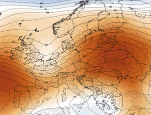
Europe Braces for a Tropical Heatwave: Could September End with an Indian Summer
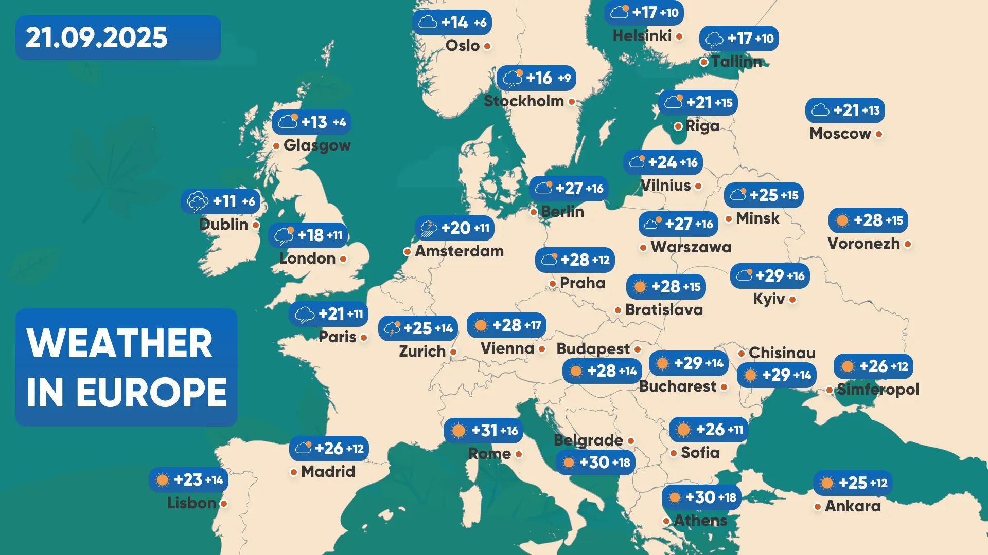
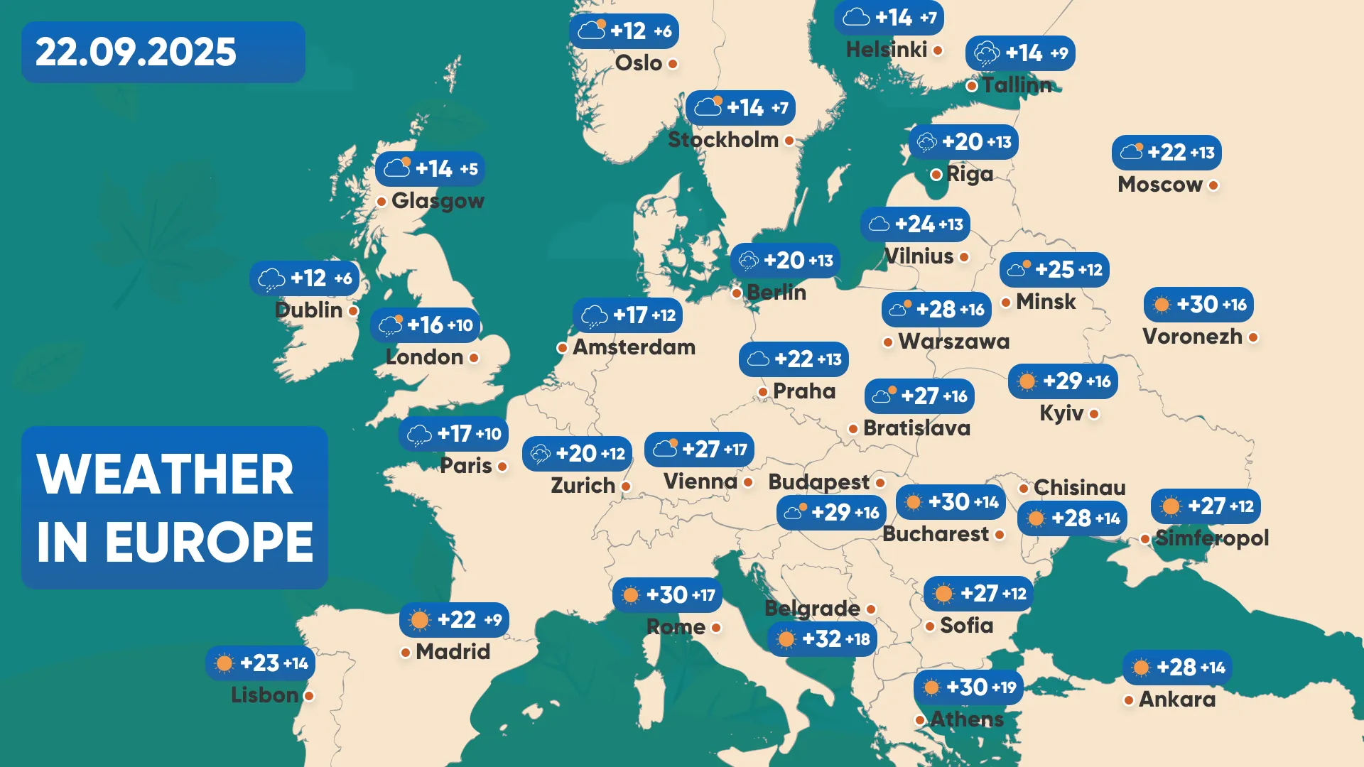
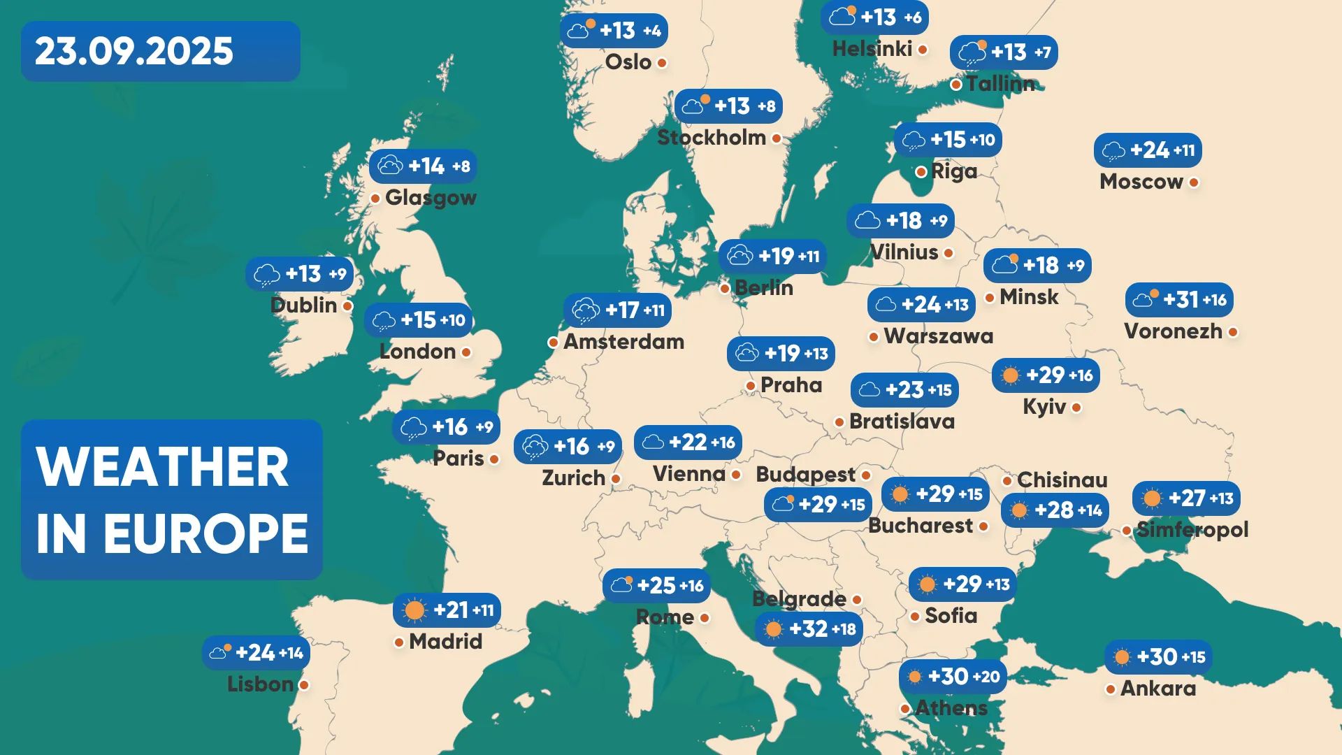
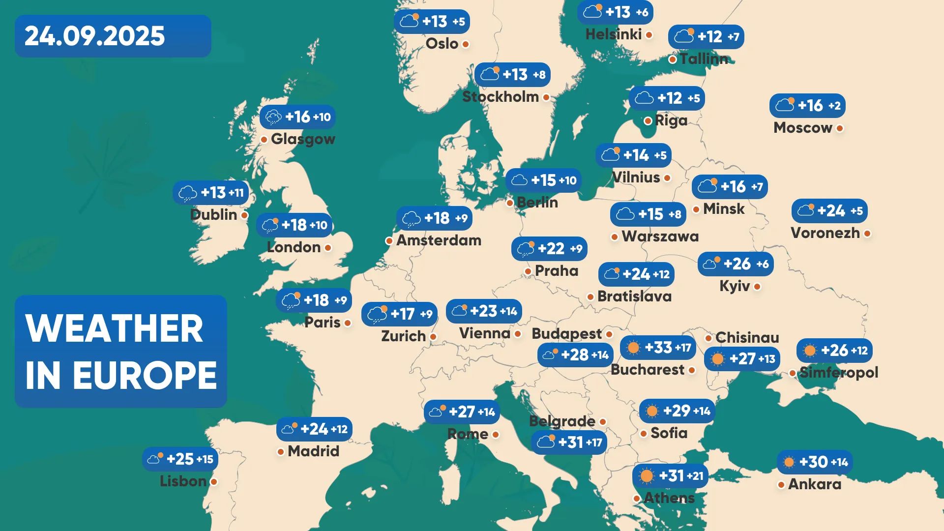
As the calendar heads towards the final week of September 2025, Europe may be in for an extraordinary twist in its weather pattern. Far from the usual gradual cooling into autumn, a surge of tropical air is expected to sweep across large parts of the continent between September 20 and 24. Forecasts from leading models, including ECMWF, show an unseasonably strong pulse of warmth moving from the south into Central and Eastern Europe. This raises the prospect of an authentic Indian Summer unfolding across multiple countries, from the Balkans and Ukraine to Poland, Germany, and the Baltic States.
Atmospheric Drivers: Why is Europe Heating Up?
This heatwave will not be a random fluctuation but the result of a clear synoptic setup. Over northwestern Europe, a deep upper-level trough is forecast to develop. This structure will act as a “pump,” drawing warm subtropical air masses northward and eastward. Simultaneously, a powerful anticyclone is expanding over the Balkans, extending its ridge into Central and Eastern Europe. This atmospheric configuration – trough to the northwest, ridge to the southeast – creates a conveyor belt of tropical warmth spreading across the continent.
The significance lies in the origin of these air masses. Unlike standard late-September warm spells driven by local solar heating, this surge has a tropical component. It brings not only elevated temperatures but also the potential for unusual humidity contrasts, clearer skies in some regions, and dynamic weather transitions where the warm air mass meets cooler Atlantic flows.
Regional Outlook Indian Summer
Western Europe (Germany, France, Benelux): Western Europe will initially remain on the cooler side, closer to the influence of the Atlantic trough. However, even here, temperatures will temporarily rise, especially in southern Germany, where daytime highs may reach +24…+26°C. France and the Low Countries will see milder warmth, closer to +20…+23°C, with local variability depending on cloud cover.
Central Europe (Poland, Czechia, Slovakia, Hungary): The heart of Europe is forecast to feel the most balanced mix of summer-like warmth. Poland may experience highs of +23…+27°C, especially in the south and east. Hungary and Slovakia are likely to see +26…+28°C, with sunny spells reinforcing the feeling of late-summer weather.
Southern Europe (Balkans, Romania, Bulgaria, Greece): The Balkans will be at the core of the anticyclonic influence. Romania and Bulgaria are set for highs of +27…+30°C, potentially exceeding 30°C in local valleys. Greece will, of course, remain very warm, with widespread +29…+32°C – extending what is already a hot September.
Eastern Europe (Ukraine, Belarus, Moldova): Ukraine stands out in this forecast. Southwestern regions (Odesa, Kherson, Chernivtsi) may reach +28…+29°C, while central Ukraine (Kyiv, Vinnytsia, Cherkasy) can expect +23…+26°C. The north will be milder at +20…+23°C, but still warmer than seasonal norms. Eastern oblasts will gradually warm towards +25°C by Sunday and Monday. Moldova will share similar conditions, with widespread +27…+28°C. Belarus will be a degree or two cooler, hovering around +21…+24°C.
Northern Europe (Baltic States, Scandinavia): The warmth will extend further north than usual. Lithuania, Latvia, and Estonia may record highs of +21…+24°C – remarkable values for late September. Southern Scandinavia (Denmark, southern Sweden) may temporarily reach +18…+21°C, though cooler maritime air will limit extremes.
Impacts Across Europe
Travel and Lifestyle: The late warmth will provide ideal conditions for city tourism, outdoor events, and weekend getaways. Expect crowded parks and beaches along the Black Sea coast, as many seize what may be the last taste of summer.
Agriculture: Extended warmth will benefit the ripening of late crops, especially grapes, maize, and sunflower. However, the contrast with cooler nights may also raise concerns for fog formation and increased dew, affecting harvesting logistics.
Energy and Infrastructure: The surge in temperatures will temporarily reduce demand for heating across Central and Eastern Europe, offering relief for energy consumption. Yet, sudden swings back to cooler, wetter weather – expected after September 24 – could stress systems as demand quickly rises again.
Looking Ahead: Will the Warmth Last? Meteorological signals suggest that this Indian Summer will be brief. By mid-next week, as the trough over northwestern Europe deepens further, cooler Atlantic air will reassert itself. This transition could be abrupt, leading to showers, gusty winds, and a noticeable drop in temperatures. Northern and western Europe will feel the cooldown first, followed by Central and Eastern regions.
For early October, climatological patterns favour a return to more typical autumn conditions: shorter spells of warmth, more frequent Atlantic fronts, and increased rainfall, particularly in northern Europe. The late-September tropical episode, therefore, stands out as an exception – a reminder that the atmosphere still holds summer’s energy, even as the season tips into autumn.
Between September 20 and 24, 2025, Europe will witness a surge of tropical warmth, with widespread highs in the mid-20s to near 30°C across Central, Southern, and Eastern regions. While Western Europe will be less affected, the entire continent will feel the shift, making this one of the most striking weather events of the month.
For many, this will be a welcome reprieve – a last opportunity to enjoy summer-like conditions. Yet for meteorologists, it is also a reminder of how dynamic and interconnected Europe’s weather truly is. The balance between Atlantic troughs and Balkan ridges may well decide how the rest of autumn unfolds.
The Founder and Chief Meteorologist at Pogodnik.com. With over 15 years of operational experience in synoptic analysis and climate forecasting, he specializes in storm tracking, magnetic storms, and atmospheric dynamics. A recognized expert in Ukraine’s meteorological sector, he maintains strategic collaborations with global agencies, including NOAA and ECMWF, to ensure high-precision data integration. His analytical reviews and scientific contributions are regularly featured in leading media outlets dedicated to weather science and environmental trends.