Europe Weather Forecast May 2026: Regional and Weekly Outlook
The Europe weather forecast for May 2026 points to a genuinely contrasting month across the continent. On one side, the lingering signal from the spring breakdown of the polar vortex — which dropped its last cold cores into northern latitudes back in April. On the other, the rapid transition from La Niña to El Niño in the tropical Pacific, which is already reshaping atmospheric circulation over Europe. In this detailed May 2026 weather outlook for Europe, you will find a professional region-by-region and week-by-week breakdown covering heat, floods, thunderstorms, hail, and wildfire risk.
This forecast is built on the latest data from the European ECMWF model (seasonal SEAS5 and sub-seasonal EC46 on 46 days), the German ICON-EPS from DWD, the U.S. CFSv2 from NOAA, the Copernicus C3S multi-model consensus (update from 10 April 2026), the EFFIS long-term fire danger service, and the official NOAA ENSO Diagnostic Discussion from 9 April 2026.
Key takeaways for the May 2026 weather in Europe
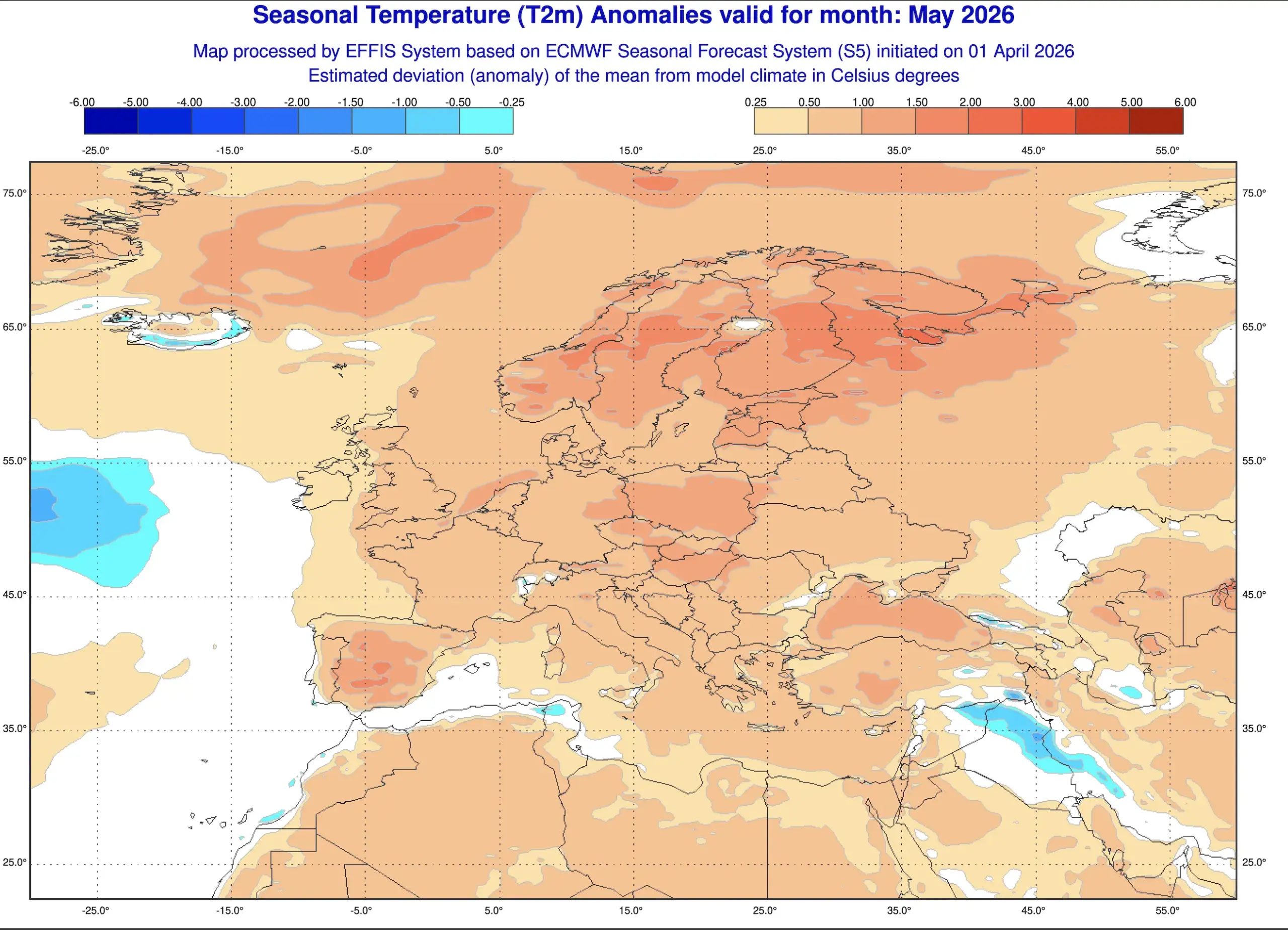
Temperature background — above the 1991–2020 climate normal across most of the continent, strongest over the southeast and the Mediterranean (+1…+2.5 °C).
Precipitation — above normal over the west and central Europe, near normal in the north, with a clear deficit over the Iberian Peninsula and southern Italy.
First heatwaves in the Mediterranean and the Balkans — already by mid-month, with peaks up to +32 °C.
Peak of thunderstorms and hail — central Europe and the Alps, 15–25 May.
Flood risk — Alps, Carpathians, Pyrenees, western Balkans, especially where snowmelt meets heavy rainfall.
Wildfire danger — rising over southern Spain, Portugal, southern Italy, and the southeastern Balkans in the last 10 days of May.
What drives the weather in Europe in May: two main forces
La Niña collapse and El Niño onset
On 9 April 2026, the U.S. Climate Prediction Center (NOAA CPC) officially announced the end of La Niña and placed the system on El Niño Watch. ENSO-neutral conditions are favored through May–July 2026 (55% probability), with El Niño likely to emerge in June–August at 62% probability. The independent CCSR/IRI center gives an even more aggressive signal — 70% chance of transition to El Niño already in May–June 2026.
For Europe this transition brings one thing above all: heightened atmospheric variability. In years of a rapid pivot from La Niña to El Niño, low pressure tends to strengthen over western and central Europe, more moisture streams in from the Atlantic and the Mediterranean, and the southeast ends up in a zone of warm anomalies. That is the classic “contrast axis” — a wet west versus a hot and dry southeast. Exactly this pattern is now showing up in the ECMWF and UKMO seasonal forecasts for spring 2026.
Residual polar vortex and blocking highs
The past winter and early spring featured two separate polar vortex splits — one in February and another in March. The stratospheric Final Warming kicked in on 9 April, but a residual cold core in the lower atmosphere keeps spinning over Canada and the North Atlantic. This sustains a wavy jet stream pattern over Europe and raises the odds of blocking highs over Scandinavia, the Urals, or the Balkans. The practical consequence: an alternation of warm “heat domes” and Atlantic cold intrusions in the first half of the May 2026 weather pattern across Europe.
Europe weather May 2026 by region
Western Europe: UK, Ireland, France, Benelux
Temperatures are near normal or 0.5 °C above. The ECMWF seasonal signal shows low pressure over the British Isles and northern France, with frequent Atlantic cyclones.
London, Dublin, Amsterdam: +13…+19 °C by day, +7…+11 °C at night. Regular rainfall, 12–15 rainy days expected.
Paris, Brussels: +15…+22 °C, with thunderstorms and possible hail in the second half of the month.
Southern France (Lyon, Marseille, Nice): +18…+26 °C, reaching +28 °C on the French Riviera by late May.
The main risk is recurring river flooding in France, particularly in the Rhône and Seine basins, when Alpine snowmelt overlaps with heavy rainfall during the second dekad.
Central Europe: Germany, Poland, Czechia, Austria, Slovakia, Hungary
Temperatures run 0.5–1.5 °C above normal. This region is the hotspot for thunderstorm activity in May 2026 — where warm southern air meets cool Atlantic air head-on.
Berlin, Warsaw, Prague, Vienna, Bratislava, Budapest: +16…+23 °C by day, +7…+12 °C at night.
In the second half of May, daytime highs climb to +25…+28 °C.
15–25 May — peak thunderstorms with hail 2–4 cm in diameter and wind gusts up to 25 m/s in the corridor from southern Germany through Czechia, Austria, and into Hungary.
Alpine rivers (Danube, Isar, Inn, Salzach) — high flood risk from high-altitude snowmelt above 1800 m combined with heavy rain.
In Poland and eastern Germany, the first days of May still carry a residual risk of night frosts of −1…−3 °C in valleys — the final breath of the northerly flow.
Northern Europe: Scandinavia, Baltic states
Norway, Sweden, Finland, Estonia, Latvia, Lithuania — a region where the model signal is weak but leans neutral-to-warm. Temperatures are near normal or 0.5 °C above.
Oslo, Stockholm, Helsinki: +10…+17 °C by day, +3…+8 °C at night.
Tallinn, Riga, Vilnius: +13…+19 °C, reaching +22 °C in the final dekad.
In the first days of May, snow showers remain possible in northern Scandinavia.
Long daylight hours and the first “white nights” north of 60°N deliver excellent outdoor-travel weather from mid-month onward.
Southern Europe: Spain, Portugal, Italy, Greece, Malta, Cyprus
This is the primary warm-anomaly zone in the May 2026 weather pattern across Europe. Copernicus C3S gives a 60–70% probability of temperatures exceeding the upper quintile — which means this will rank among the warmest Mays of the past 30 years.
Madrid, Barcelona, Lisbon, Seville: +22…+29 °C, with Andalusia reaching +32…+34 °C in late May.
Rome, Naples, Palermo: +20…+27 °C, Sicily peaking at +30 °C by month’s end.
Athens, Thessaloniki, Heraklion (Crete): +22…+28 °C, sea warming to +20…+22 °C.
Malta, Cyprus: +23…+28 °C — beach season in full swing.
The main concern here is early-season drought and wildfire danger. According to EFFIS and Copernicus projections, by the last 10 days of May the Fire Weather Index (FWI) shifts from “moderate” to “high” across southern Spain, central Portugal, southern Italy, and the Peloponnese. Farmers should activate drip irrigation systems early.
Southeastern Europe: Balkans, Romania, Bulgaria
Croatia, Serbia, Bosnia and Herzegovina, Montenegro, Albania, Romania, Bulgaria — a region where May temperatures will run 1–2 °C above normal, with a contrasting precipitation regime: the western Balkans get more rain, the eastern Balkans less.
Zagreb, Sarajevo, Belgrade: +18…+25 °C, frequent thunderstorms in the second half.
Dubrovnik, Split, Kotor: +20…+25 °C, sea +19…+21 °C. Beach season opens.
Sofia, Bucharest: +19…+26 °C, brief spikes to +29…+31 °C at month’s end.
Western Balkans (Dinaric Alps) — elevated risk of convective floods in mountain rivers between 15–25 May.
Eastern Europe: Ukraine, Belarus, Moldova, European Russia
Temperatures run 0.5–2 °C above normal. In the first dekad, night frosts remain possible over the north (Belarus, northern Ukraine, European Russia). In the second half, the first genuine heatwave arrives across the southeast.
Kyiv, Minsk: +15…+23 °C, with late-May peaks of +26…+28 °C.
Chișinău: +18…+26 °C.
Moscow, Saint Petersburg: +13…+21 °C, occasionally up to +24 °C in the second half.
Southern European Russia, Crimea, Kuban: +22…+30 °C, with local spikes up to +33 °C in late May.
Flood risk remains elevated in the Carpathians (Tisza, Prut, Cheremosh, upper Dniester), particularly between 15–25 May during heavy convective rainfall events.
May 2026 weather in Europe week by week
Week 1 (1–7 May): cool start in the north, warmth in the south
A wavy westerly flow and the residual action of the northern cold core deliver unsettled weather with frequent fronts over Central and Eastern Europe. Meanwhile, the south already settles into a summer-like high-pressure regime.
North and east: +10…+18 °C; Poland, the Baltics, Belarus, and Ukraine carry a risk of night frosts in low-lying areas.
Center: +14…+20 °C, frequent rainfall.
South (Mediterranean): +22…+28 °C, sunny.
Week 2 (8–14 May): transition to warmth
The Mediterranean high expands northeast. The first warm wave reaches the Alps, southern Germany, and northern Italy.
North: +14…+20 °C.
Center: +17…+24 °C.
South: +23…+30 °C; sea warming to +18…+20 °C.
Week 3 (15–21 May): peak thunderstorms, floods, and first heat waves
The most dynamic stretch of the month. The ECMWF EC46 sub-seasonal model and the CFSv2 ensemble both show intensifying meridional flow — warm southern air clashes with cool Atlantic air.
Central Europe: +20…+26 °C, thunderstorms with hail up to 3–4 cm and gusts up to 25 m/s. The risk corridor stretches from southern Germany through Czechia, Austria, into Hungary and northern Croatia.
Alps, Carpathians, western Balkans: rainfall totals of 40–60 mm per 24 hours; flood risk on the Danube, Drina, Tisza, Prut, Cheremosh.
South: +26…+32 °C, first heat wave across Spain, Italy, Greece.
North: +16…+22 °C, cooler than the background signal.
Week 4 (22–31 May): summer regime, heat in the southeast
The CFSv2 model, initialized with data from 9–18 April, locks in a persistent positive temperature anomaly of +1…+2 °C across most of the continent. Summer effectively starts ahead of the calendar.
Iberian Peninsula: +28…+34 °C; Seville and Córdoba locally up to +36 °C. Dry.
Italy, Greece: +26…+32 °C; Sicily and the Peloponnese may reach +33 °C.
Balkans, southern Ukraine, Romania, Bulgaria: +27…+33 °C, dry winds (“sukhovey”) in the south.
Central Europe: +23…+28 °C, thunderstorm fronts every 2–3 days.
North: +18…+24 °C, comfortable.
Europe flood risk May 2026: regional map
The combination of melting mountain snow and forecast heavy rainfall creates a high flood risk in several key regions:
Carpathians (Ukraine, Romania, Slovakia) — Tisza, Prut, Cheremosh, upper Dniester. Fast-response local floods with 1.5–3 m water rises over half a day.
Western Balkans (Bosnia, Montenegro, Albania, Croatia) — Drina, Neretva, Morača. Elevated sensitivity after a snowy winter.
Pyrenees (Spain, France, Andorra) — upper Ebro, Garonne, Adour. Risk during sudden downpours.
Western and southwestern France — Rhône, Seine, Loire basins — high sensitivity following heavy winter and February rainfall that already saturated soils.
Thunderstorms, hail and wind gusts: geographic hotspots
Peak thunderstorm activity in Europe runs 15–25 May. Zones of elevated risk include:
Wind gusts 20–30 m/s — southern Germany, Czechia, Austria, Hungary, Slovakia, northern Croatia, northern Serbia, central Ukraine.
Hail 2–4 cm — Bavaria, Baden-Württemberg, the Czech–Austrian border, Hungary’s Pannonian region, northern Italy (Lombardy, Veneto).
Supercells and a limited tornado risk — the Po Valley in Italy, the Pannonian Plain in Hungary, southern France (Languedoc).
Dust storms and dry winds — southern Spain, inland Turkey, southern Ukraine, and southern European Russia in the last 3–4 days of May.
Wildfire danger: the Mediterranean in the red zone
The long-term EFFIS forecast and Fire Weather Index monitoring show that by the last dekad of May 2026 the background wildfire risk zone expands significantly. The most concerning signals are for:
Southern and central Spain (Andalusia, Castilla-La Mancha, Extremadura);
Inland Portugal (Alentejo, Algarve);
Southern Italy and the islands (Campania, Calabria, Sicily, Sardinia);
Southern Greece and the Peloponnese;
Inland Turkey and southern Balkans;
Southeastern Ukraine and southern European Russia.
Recent years have shown that Europe’s fire season is expanding — intense heat waves and dry spells create ideal conditions for large, uncontrollable wildfires earlier in the season than ever before.
Forecast consistency: what different models say
To evaluate forecast reliability, I’ve compiled the signals from the world’s leading prediction centers:
Model / center
Temperature in Europe
Precipitation in Europe
ECMWF SEAS5
Above normal by 0.5–1.5 °C, strongest in the southeast
Above normal in the west and center, deficit in Iberia
NOAA CFSv2
Above normal by 1–2 °C across most of the continent
Near normal, with deficit in the south and southeast
Copernicus C3S (multi-model)
60–70% probability of “above normal” in the south and center
Slight surplus in the west, deficit in the southwest
Model agreement is high on the temperature signal — every center points to a warm May 2026 in Europe with a southern emphasis. Agreement on precipitation is moderate: all models agree on a deficit over the Iberian Peninsula and a surplus across the Alps and western Europe, but details over central Europe diverge.
May 2026 travel and lifestyle tips by region
Mediterranean travelers — the sweet-spot window is 10–25 May: warm but not peak heat. Crete, Malta, Cyprus, Sicily deliver +23…+28 °C air and +20…+22 °C sea.
Central Europe travelers — prepare for thunderstorms, especially 15–25 May. Pack an umbrella and a light rain shell.
Mountain and hiking enthusiasts — the Alps and Carpathians snow line starts around 1800–2000 m in early May and rises to 2500 m by month’s end. Lowland trails become reliable from 10–12 May.
Farmers — in the south, activate early irrigation; in the center, watch for hail in the second dekad; in the east, delay warm-season crop planting until 12–15 May.
Residents of the Pyrenees and Balkans — monitor flood warnings from national hydrometeorological services during the second dekad.
Where to track the weather in Europe in May 2026: trusted site and app
For real-time weather tracking, severe-weather alerts, and long-range forecasts, I recommend the Pogodnik resources:
Pogodnik website (pogodnik.com/en) — long-range forecasts across Europe, seasonal outlooks, weather-risk analysis, plus news on magnetic storms, severe storms, and volcanic activity.
Pogodnik app for smartphones — live hourly forecasts with alerts for thunderstorms, floods, and magnetic storms, a precipitation radar, and a lightning tracker. Powered by ECMWF and GFS model integration and free of intrusive ads — equally useful for travelers, farmers, and drivers.
The app is especially handy for anyone traveling across Europe in May — push notifications about incoming thunderstorms, hail, and sharp cold snaps help you plan your day on the road.
Bottom line: the May 2026 Europe weather forecast — a month of warmth and contrasts
The May 2026 weather forecast for Europe points to a month of pronounced warm background with vivid contrasts. The north sees a cool, damp start; the south is already almost summery from day one. Central Europe enters a genuine thunderstorm season with hail and strong gusts in mid-month. The Mediterranean faces early heat and a rising wildfire threat by late May. Mean temperatures across most of Europe will run 0.5–2 °C above climate normal, while the precipitation pattern stays contrasting: surplus in the west and the Alps, deficit on the Iberian Peninsula and in southern Italy.
The month’s main risks: floods in the Alps, Carpathians, western Balkans, and the Pyrenees (15–25 May), severe thunderstorms with hail across central Europe, and early-season heat plus wildfire danger in southern Europe in the last 10 days.
This Europe weather outlook for May 2026 is built on the most up-to-date data from ECMWF SEAS5 + EC46, ICON-EPS, NOAA CFSv2, the Copernicus C3S multi-model consensus, UKMO, and the EFFIS fire-danger service — the same sources relied on by every national meteorological service in Europe.
Seasonal forecasts describe probable tendencies, not day-by-day weather. A warm background does not rule out brief cold snaps and local anomalies. For operational decisions, always cross-check with the daily forecast and official warnings from national meteorological services — and for convenient daily tracking, use the Pogodnik app.
The Founder and Chief Meteorologist at Pogodnik.com. With over 15 years of operational experience in synoptic analysis and climate forecasting, he specializes in storm tracking, magnetic storms, and atmospheric dynamics. A recognized expert in Ukraine’s meteorological sector, he maintains strategic collaborations with global agencies, including NOAA and ECMWF, to ensure high-precision data integration. His analytical reviews and scientific contributions are regularly featured in leading media outlets dedicated to weather science and environmental trends.


 Europe Weather Forecast May 2026: Regional and Weekly Outlook