Winter 2025–26 in Motion: Atmospheric Rivers, Early Stratospheric Warming and the Coming Cold Surge Across North America and Europe
As we move toward winter 2025–26, the forecast is no longer about waiting for the cold to arrive—it’s about recognizing how the next season is already developing. From atmospheric rivers flooding California to a rare early stratospheric warming event disrupting the polar vortex, the dynamic is shifting rapidly. Here’s what the latest observations and forecasts reveal—and how they reshape what we thought we knew about the winter ahead.
🌬️ 1. Current Events Setting the Stage
California Braces for Multi-Day Atmospheric River
On November 13, 2025, a potent atmospheric river began targeting California, carrying heavy rain, strong southwest winds and elevated flash-flood potential across northern, central and southern parts of the state.
This is not just a localized weather event—it’s a sign of a moist, energetic Pacific—and thus a factor in broader winter dynamics. When such moisture surges occur, they influence storm tracks, soil saturation and snow-/rain-distribution patterns that set up winter behavior.
Early Stratospheric Warming Could Disrupt the Polar Vortex
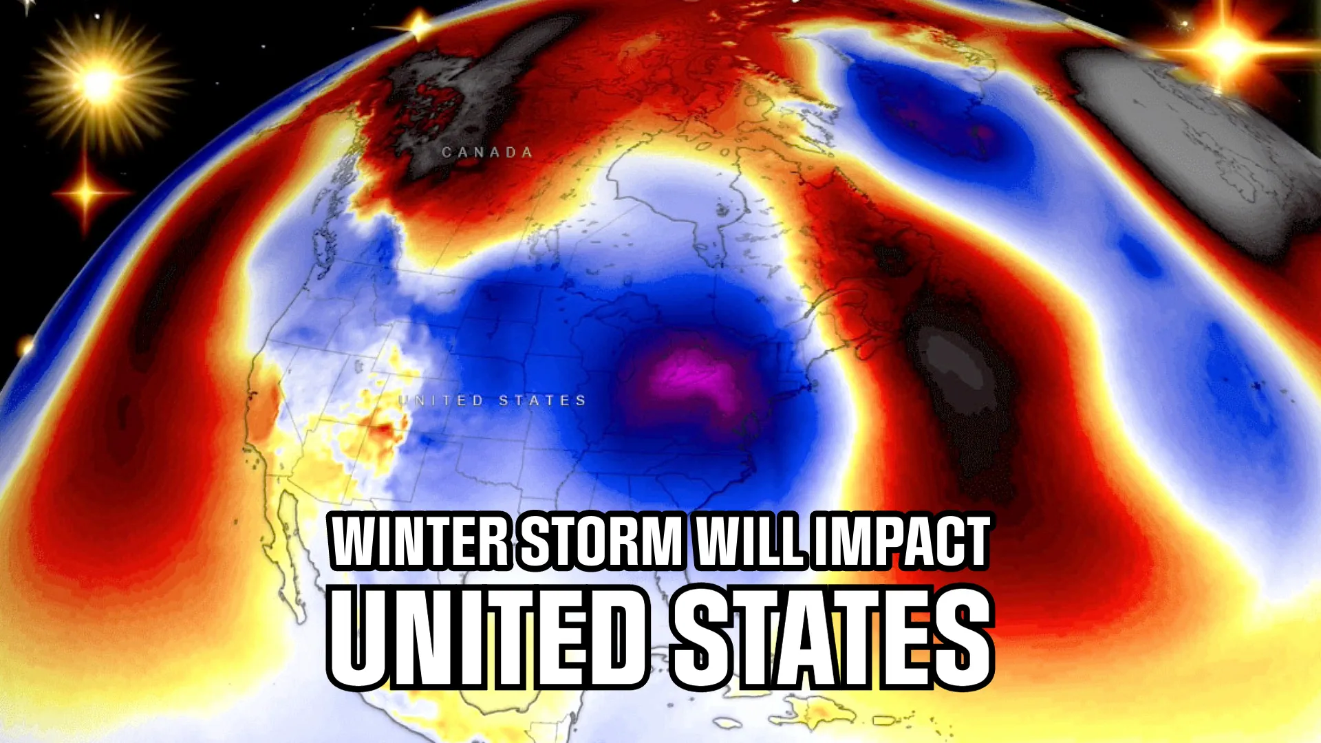
Multiple model ensembles (ECMWF, GFS) now indicate a stratospheric warming event is underway in the late November period, above the Arctic. (The Watchers) The warming wave at ~10 hPa is producing above-normal temperature anomalies, deforming the polar vortex’s structure and raising the odds of cold air release.
In simple terms, when the polar vortex weakens, the “wall” holding Arctic air in place falters—and that cold can spill south. For winter 2025–26 this mechanism is coming earlier than usual.
Flash Floods & Burn-Scar Risks in California
In California’s Mono County, heavy rains following the “Pack Fire” (burn scars) are causing evacuation warnings and high mud-flow risk. (CBS News) This kind of event underscores how unusual moisture surges + terrain vulnerabilities combine—an indicator of how climate systems are primed for greater extremes.
📊 2. What These Events Mean for the Winter Forecast
A Wet Start, Not Immediately Cold
Because of the atmospheric river activity and strong Pacific moisture feed, large parts of North America (especially the West) and Europe (via Atlantic flow) will begin winter with enhanced precipitation—rain, mountain snow, elevated storm risk—rather than a sudden cold snap.
Cold Waves on the Horizon
However, thanks to the early stratospheric warming & weakening of the polar vortex, the “late winter cold” is shifting forward. Forecasts show the disruption of the vortex in mid- to late November could unlock cold air and drive Arctic outbreaks into North America and eventually Europe.
Divergence: North America vs Europe
- In North America, the collapsing vortex and La Niña synergy favour earlier and deeper cold infiltration, especially in Canada and the U.S. from the Plains eastward.
- In Europe, the current picture is milder and wetter, but the tipping point may arrive when the vortex disruption effects propagate. Europe may then pivot rapidly into a more unmistakable winter mode.

🗺️ 3. United States & Canada: Winter 2025–26 Scenario
December
Expect the first major cold breakout of the season. With the vortex weakening, models show cold anomalies building across northern Canada into the Plains and Midwestern U.S., leaving the West and Southwest comparatively warmer. Snow should develop early across the Great Lakes, Ohio Valley and possibly farther south than usual.
January
This will likely be the heart of the action. With the vortex already impaired and the La Niña pattern in place, be ready for multiple Arctic surges, expanded snow belts and an active winter for the northern half of the continent. If a full Sudden Stratospheric Warming (SSW) event occurs, February may bring the most significant outbreak.
February
If the SSW and vortex collapse scenario play out, the cold could deepen and lengthen. The Plains, Mid-Atlantic and interior South could see rare Arctic infiltration for this time of year. If SSW does not happen, the pattern will default to persistent but less intense cold and snow across the northern tier.
Snow & Impacts
- High snow potential in the Upper Midwest, Great Lakes, Ontario, and southern Canada.
- Fallback areas: interior Northeast, Appalachians and even deeper south during major events.
- Risk sectors: energy grids, agriculture (late freezes), transport/logistics during unexpected early storms.

🇪🇺 Europe: Winter 2025–26 Outlook
December
Europe begins the meteorological winter with mild, stormy and wet conditions. Strong Atlantic storms, saturated soils and frequent rain will define much of the early period. Snow will remain mostly confined to high altitudes and northern latitudes.
January
Here is where the transition may occur. The early vortex disruption may finally transmit down to the troposphere, especially if blocking builds over Greenland. That means cold blasts in Northern and Eastern Europe become more likely, especially if the Atlantic storm track shifts south or weakens.
February
The “make-or-break” month. If all aligns—vortex collapse + Greenland block + depleted Atlantic moisture—then major cold and widespread snow becomes possible even in Central Europe. If not, winter remains mild, wet and cyclone-dominated.
Regional Notes
- Western Europe (UK, France, Germany): Mild above average temperatures (+1–2 °C), high rainfall, early snow limited to mountains.
- Eastern Europe (Poland, Ukraine, Baltics): Moderate trend, but increased likelihood of “cold windows” and early snow from later winter.
- Northern Europe/Scandinavia: Best situated for traditional winter conditions; early cold surges likely if blocking develops.
🧩 4. Integrating the New Factors
Atmospheric Rivers = Moisture Pre-Load
That California atmospheric river event is emblematic of how water-rich storms are entering the system earlier. Wet soils, high snow-elevation start zones and enhanced hydrological energy prime sectors for downstream winter impacts (snowmelt risk, flash floods, avalanche zones).
Early Stratospheric Warming = The Trigger
The developing higher-altitude warming wave is the season’s wild card. If it proceeds and the vortex weakens, the timing of the cold becomes advanced. In past seasons, early SSWs preceded heavy December cold outbreaks.
Vortex Weakness = Higher Volatility
A weak vortex means the atmosphere is less “stable” — its circulation more easily perturbed by waves from the south. That means cold lobes may penetrate farther, snow belts may shift and weather patterns may flip faster than traditional models suggest.
Pattern Split: Passive West vs Active East
- The West and Southwest USA may begin mild/dry, but become vulnerable to rare but strong winter storms.
- The East and Canada stand to bear the brunt of early winter cold, especially if the vortex release occurs early.
- In Europe, the early phase is dominated by moisture and mild temperatures, but the real winter may arrive abruptly if the atmospheric architecture switches.
🎯 5. What to Monitor (and When)
- Model ensembles for stratospheric winds at 10 hPa — sharp drops = vortex weakening.
- 500 hPa geopotential height anomalies — blocking signatures over Greenland or deep troughs over N. America.
- Atmospheric river indices and soil moisture trends — heavy pre-loading of the system leads to more energetic storms or spring-type early snowmelt.
- Snow cover and depth trends in Canada, Great Lakes and the Alps — early accumulation is a signal of momentum.
- Sea surface temperature anomalies in the North Atlantic — warm pool = strong storm track = delayed winter cold; cool pool = early cold.
Winter Now Has Momentum
Winter 2025–26 is no longer looming—it is in motion. We already see major hydrologic events (atmospheric rivers), stratospheric disturbances, and early cold spells. The stage is set for a winter that may start mild and wet in places, but has the potential for dramatic cold and snow—particularly if the polar vortex falters.
- In North America, expect the first major winter bursts sooner than usual, possibly beginning in December.
- In Europe, brace for a storm-filled autumn sliding into winter, with the real cold possibly arriving late January or February.
- For both continents, the timing and amplitude of cold depend now on stratospheric and polar vortex dynamics far more than on classic ENSO indicators alone.
In short: if you thought winter would show up slowly and gently—think again. This season is ramping up, and when the flip happens, it might be abrupt and intense.

Gleb Perov is the founder and chief meteorologist of POGODNIK, a leading weather forecasting service in Eastern Europe. With over 15 years of hands-on experience in meteorology and climate analysis, he has worked private weather services.
Gleb is the author of numerous scientific and analytical publications on climate, magnetic storms, and atmospheric processes. He regularly collaborates with major international agencies such as NOAA, ECMWF.


