Tropical Storm Tapah Slams Hong Kong with T8 Warning: Brace for Chaos!
Hong Kong is on high alert as Tropical Storm Tapah barrels toward the region, triggering a T8 Gale or Storm Signal issued by the Hong Kong Observatory at 21:20 LT (13:20 UTC) on September 7, 2025. With gale-force winds of 63 km/h (39 mph) or higher expected to batter the city into September 8, residents are bracing for severe weather, potential flooding, and widespread disruptions. The storm is forecast to make landfall in western Guangdong on September 8, potentially leaving a trail of chaos in its wake.
🚨LANDFALL: Typhoon Tapah, another quick-hitting storm that has formed in the coastal shallows of the West Pacific, just made landfall over the town of Haiyan, China with winds of 75 mph (120 kph) and a pressure of 984 mbar.
Tapah’s brisk organization from a weak Tropical Storm… pic.twitter.com/bCf6M29Odn
— Backpirch Weather (@BackpirchCrew) September 8, 2025
Tapah’s Path and Power
As of 00:00 LT (16:00 UTC) on September 8, Tropical Storm Tapah was centered approximately 250 km (155 miles) south-southwest of Hong Kong, moving northwest to north-northwest at 18 km/h (11 mph). The storm is expected to pass within 200 km (124 miles) southwest of the city around sunrise on September 8, bringing squally showers, thunderstorms, and very rough seas. According to the Joint Typhoon Warning Center (JTWC), Tapah’s forecast track indicates a direct hit on western Guangdong, with Hong Kong likely to experience significant impacts from its outer bands.
Wind measurements across the region underscore the storm’s intensity. In the past hour, maximum sustained winds reached 60 km/h (37 mph) at Ngong Ping, 53 km/h (33 mph) at Cheung Chau Beach, and 51 km/h (32 mph) at Tap Mun. Gusts were even fiercer, exceeding 89 km/h (55 mph), 65 km/h (40 mph), and 60 km/h (37 mph) at these locations, respectively. The Hong Kong Observatory has warned that the T8 signal, indicating sustained winds of 63 km/h or above, will likely remain in effect until at least 11:00 LT (03:00 UTC) on September 8. Unless Tapah unexpectedly intensifies or shifts closer, the likelihood of escalating to a higher warning signal remains low.
The Hong Kong Observatory issued No 8 signal as Typhoon Tapah made landfall on Sunday night, prompting about 100 flight cancellations. HK SAR government departments received about 162 reports of fallen trees. pic.twitter.com/nRrtiYbEzS
— China Daily Hong Kong (@CDHKedition) September 8, 2025
Coastal Flooding and Storm Surge Risks
The combination of Tapah’s storm surge and spring tides is raising alarms about potential flooding, particularly in low-lying areas of western Hong Kong. Coastal water levels are expected to rise significantly above normal, posing a serious risk to infrastructure and communities. The Observatory has urged residents to take immediate precautions, including securing doors and windows, reinforcing shutters, clearing blocked drains, and avoiding exposed windows to minimize risks from flying debris and high winds. Residents are also advised to stay informed through radio, television, or the HKO mobile application for real-time updates.
The severe weather is already causing hazardous conditions, with squally heavy showers, thunderstorms, and large swells expected to intensify. Very rough seas could further complicate marine activities, and coastal areas are particularly vulnerable to the combined effects of the storm surge and tidal forces.
Widespread Disruptions Across Hong Kong
The T8 warning has triggered significant disruptions across the city. The Education Bureau announced the closure of all day schools, including primary, secondary, special schools, and kindergartens, on September 8. Decisions regarding workplaces and night schools are still under review, with authorities closely monitoring the storm’s progression.
Transportation services have also been heavily impacted. Greater Bay Airlines adjusted nine flights to and from destinations such as Xuzhou, Taipei, Zhoushan, Bangkok, and Quanzhou, with further changes possible as the storm approaches. The Airport Authority has implemented contingency measures to manage delays and cancellations, offering passenger-assistance services to mitigate the impact on travelers. While rail services, including the MTR, continue to operate normally for now, MTR Bus services are set to be suspended three hours after the T8 signal was issued. Several ferry services were also halted on the evening of September 7, further complicating travel plans.
Preparing for the Worst
The Hong Kong Observatory has issued clear guidance for residents to prepare for deteriorating conditions. In addition to securing homes and businesses, authorities have emphasized the importance of turning off neon signage to prevent hazards from high winds. The public is encouraged to stay indoors and avoid coastal areas where flooding risks are highest. For those in low-lying areas, extra vigilance is required to monitor for potential inundation.
The storm’s impact is not limited to Hong Kong. As Tapah moves toward its expected landfall in western Guangdong, communities in the region are also preparing for severe weather. The storm’s northwest trajectory suggests it could bring heavy rainfall, strong winds, and flooding to a broader area of southern China, potentially affecting millions of people.
Storm Tapah in Context: A Region on Edge
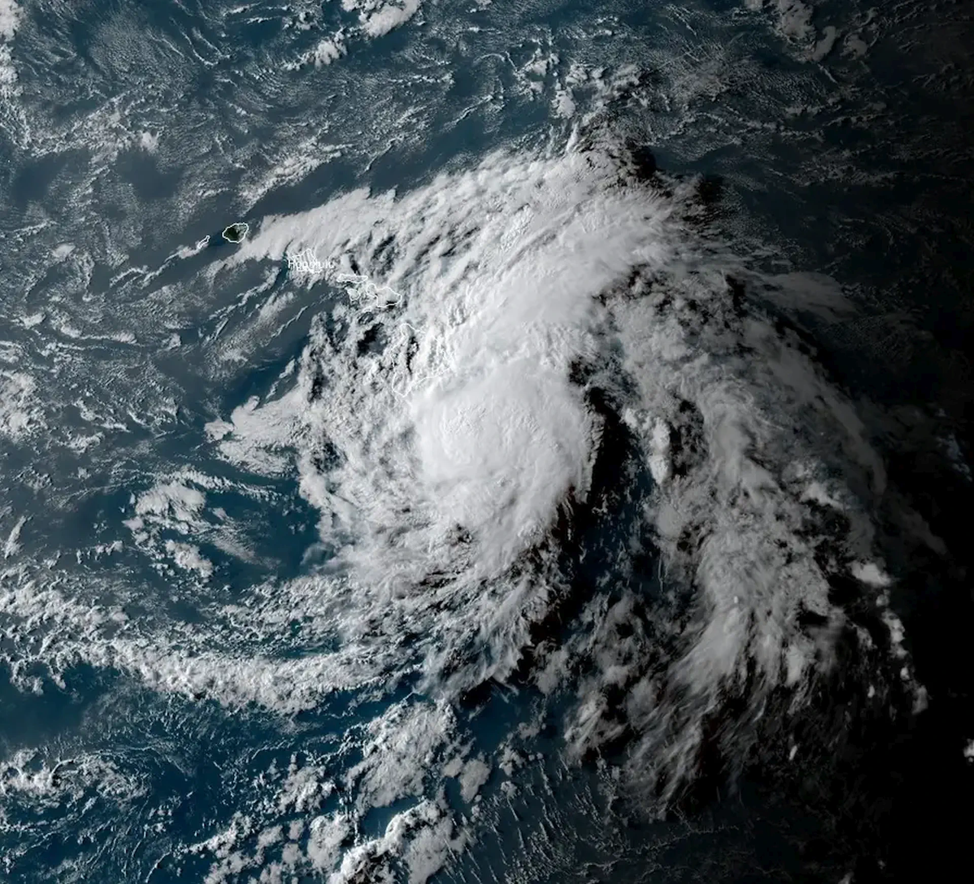
Tropical Storm Tapah is the latest in a series of weather events to challenge the resilience of Hong Kong and its neighboring regions. The city’s sophisticated infrastructure and robust warning systems have been put to the test, but the T8 signal underscores the severity of the situation. Satellite imagery from Himawari-9, provided by RAMMB/CIRA and The Watchers, captured Tapah’s ominous structure at 23:50 UTC on September 6, revealing a well-organized storm system poised to deliver significant impacts.
As climate patterns shift and extreme weather events become more frequent, Hong Kong’s preparedness measures are critical. The city’s experience with tropical storms and typhoons has fostered a culture of readiness, but Tapah’s approach serves as a reminder of the unpredictability of nature. Authorities are urging residents to remain vigilant, as even a slight deviation in the storm’s path could alter its impacts.
What to Expect Next
As Tropical Storm Tapah nears landfall, the next few hours will be critical for Hong Kong and western Guangdong. The storm’s current trajectory suggests it will skirt just southwest of the city, but any shift could bring it closer, potentially escalating the severity of the impacts. The Hong Kong Observatory will continue to monitor Tapah’s progress and provide updates as conditions evolve.
For now, residents are advised to stay indoors, avoid unnecessary travel, and keep emergency supplies on hand. The combination of high winds, heavy rain, and potential flooding demands a proactive approach to safety. Businesses and schools are preparing for extended disruptions, and travelers should expect delays or cancellations as the storm moves through the region.

Gleb Perov is the founder and chief meteorologist of POGODNIK, a leading weather forecasting service in Eastern Europe. With over 15 years of hands-on experience in meteorology and climate analysis, he has worked private weather services.
Gleb is the author of numerous scientific and analytical publications on climate, magnetic storms, and atmospheric processes. He regularly collaborates with major international agencies such as NOAA, ECMWF.


