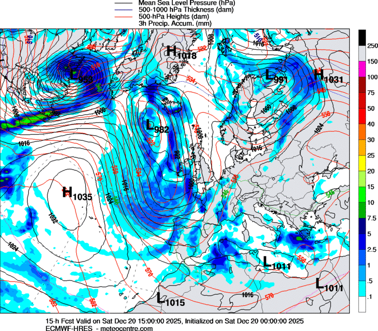
A powerful post-tropical system — the remnants of Storm Imelda — is now driving severe weather across much of Northern and Central Europe. Satellite and model analyses (ECMWF, Met Office, DeepMind’s WeatherLab) confirm the cyclone’s core pressure has dropped below 975 hPa near the Norwegian Sea, sending bands of heavy rain and gale-force winds into Scandinavia, Germany, and beyond.
Clean up crews are out and about on the Outer Banks rebuilding dunes recovering from high tides and rough surf that stemmed from Hurricane Imelda. FOX Weather Correspondent @thekatiebyrne has been on the scene in Buxton where 8 homes have succumbed to the Atlantic Ocean. pic.twitter.com/wuViX5tPoH
As Imelda accelerates into Scandinavia, the UK remains on the storm’s western flank. Winds are strong, particularly along western coasts of Scotland and Ireland, with gusts up to 70–80 km/h. Rain showers sweep across London and the southeast, but the most intense precipitation is now shifting eastwards.
Met Office guidance notes that “the most disruptive phase for the UK has passed,” yet residual instability will continue to bring scattered downpours and windy conditions for the next 24–36 hours.
Scandinavia: The Epicentre of Impact
The storm’s core is spinning just west of Norway, where the pressure gradient fuels severe winds exceeding 100 km/h in exposed coastal areas.
Norway & Sweden: Torrential rainfall and possible flooding in valleys. Travel disruptions are likely, especially in Oslo and Gothenburg regions.
Denmark: The trailing cold front is sweeping across Jutland, bringing a mix of squally showers and isolated thunderstorms.
The map clearly shows frontal zones: a strong cold front stretching from the North Sea through Germany down into France, while a warm front arcs into southern Scandinavia.
Central Europe: Heavy Rain on the Front Line
Germany, Poland, and the Czech Republic lie directly in the storm’s frontal zone. Bands of intense rain (marked yellow and orange on the chart) are forecast to deliver 40–60 mm within 24 hours. Berlin, Prague, and Warsaw may see waterlogged streets and transport delays.
The Alps, from Austria into Switzerland, are also vulnerable to orographic enhancement of rainfall. Mountain regions can expect local flash floods and landslides.
France and Southern Europe: The Tail of the Beast
France lies south of the main storm track, but Lyon, Milan, and northern Italy are already feeling the effects of the trailing cold front. Thunderstorms are embedded within the frontal band. For Spain and the western Mediterranean, calmer weather dominates, though cooler air is filtering in from the Atlantic.
Eastern Europe & the Black Sea: Secondary Disturbance
Interestingly, the map shows another active zone over the Black Sea region, with Odessa, Sevastopol, and southern Ukraine under heavy convective rainfall. This is tied not directly to Imelda, but to a secondary depression interacting with moist maritime air over the Black Sea.
Given the recent flood disaster in Odessa, these rains raise concern for further urban flooding and transport disruption. While not as intense as the main storm in Scandinavia, the persistence of moisture over the region means risks remain elevated.
Aviation and Transport Disruptions
Major airports at risk: Oslo, Copenhagen, Berlin, and Hamburg face crosswind hazards and delays due to strong gusts.
Rail & road networks: Flooding risks in central Germany and Poland could cause interruptions.
UK flights: Fewer cancellations now, but delays remain possible due to residual gusty winds.
Outlook for the Next 3–5 Days
UK & Ireland: Gradual improvement, breezy with showers.
Scandinavia: Storm peaks in 24h, then slowly weakens as it moves east into Finland and northwest Russia.
Germany & Poland: 2 days of heavy rain, then cooler, drier conditions follow behind the front.
Ukraine & Black Sea: Continued unstable weather, with rainfall episodes persisting into the weekend.
Storm Imelda is not a repeat of the catastrophic Gabriel, but it shares the same Atlantic-to-Europe transition, turning into a powerful extratropical cyclone. Its most damaging effects are now unfolding across Scandinavia and Central Europe, while secondary disturbances keep Eastern Europe unsettled.
The key takeaway: Northern Europe faces destructive winds, Central Europe braces for flooding rains, and Eastern Europe, especially Ukraine’s Black Sea coast, remains on alert for renewed downpours.
Gleb Perov is the founder and chief meteorologist of POGODNIK, a leading weather forecasting service in Eastern Europe. With over 15 years of hands-on experience in meteorology and climate analysis, he has worked private weather services. Gleb is the author of numerous scientific and analytical publications on climate, magnetic storms, and atmospheric processes. He regularly collaborates with major international agencies such as NOAA, ECMWF.


 in Two Decades")
 in Two Decades")
