Winter 2025–2026 Is Coming: La Niña, a Weak Polar Vortex, and a Cold Surprise Waiting for the U.S., Canada, and Europe
🌊 La Niña Is Back — and It’s Subtle but Strong Enough
According to the NOAA Climate Prediction Center, weak La Niña conditions are now in place and are expected to persist through the winter before fading to neutral by spring 2026.
Even though this La Niña is relatively mild, its atmospheric “fingerprint” is strong enough to reshape jet streams and shift storm tracks — fueling colder, snowier patterns across parts of North America while keeping Europe wetter and milder.
🌪️ Polar Vortex Weakening: The Early Warning
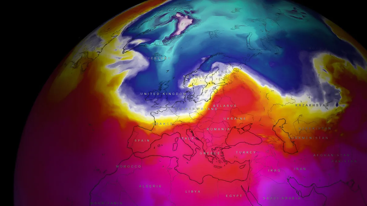
The latest ECMWF and Severe-Weather.eu analyses show that the stratospheric polar vortex has begun to slow and destabilize earlier than usual — a key sign that cold Arctic air may start spilling south sooner than normal.
Models suggest a Greenland–polar blocking setup developing in early December, which often leads to cold starts to winter across eastern North America and northern Europe.
If a Sudden Stratospheric Warming (SSW) event occurs later this winter, it could unleash severe cold outbreaks and prolonged snow episodes in January–February 2026.
🇺🇸 United States & 🇨🇦 Canada: A “Cold Launch” to Winter
📉 Temperature and Snow Outlook
- December 2025: A sharp flip to colder conditions is possible across the Midwest, Great Lakes, Ohio Valley, and Northeast U.S., extending into southern Canada. The West and Southwest stay milder.
- January 2026: Frequent “step-down” cold waves and increased snow chances for the northern U.S. and Great Lakes.
- February 2026: The wildcard month — if SSW occurs, expect a deep Arctic outbreak reaching the Plains and possibly the South.
Early freezes have already hit Texas, Oklahoma, and New Mexico, confirming the atmosphere’s readiness for early Arctic intrusions.
🌨️ Snow Zones
- Most active: Upper Midwest, Great Lakes, and Northeast U.S.
- Occasional snow: Appalachian corridor and interior Mid-Atlantic during cold surges.
- West: Mostly dry, except for periodic Pacific storms.
🇪🇺 Europe: A Delayed but Dynamic Winter
🌧️ November Sets the Stage
According to Severe-Weather.eu’s “Deep Wave” report, Europe enters winter under a wet Atlantic regime, dominated by a deep low-pressure train stretching from Iceland to Central Europe.
This setup brings a rainy and windy November, delaying any true winter onset across the continent.
❄️ December–February Outlook
- December: Mostly mild and wet across Western and Central Europe. Only Scandinavia and parts of Eastern Europe may turn briefly colder.
- January: Potential for short Arctic blasts into Northern and Eastern Europe if the polar vortex continues to weaken.
- February: If an SSW occurs, Europe could flip to a much colder phase, with blocking highs over Greenland or Scandinavia channeling Arctic air deep south.
🌦️ Precipitation
- Alps, Carpathians, Scandinavia: Frequent snow.
- Western & Southern Europe: Stormy and rainy — with flooding risks around the Mediterranean.
- Eastern Europe: Mostly rain and sleet early; snow possible later in the season.
⚙️ What’s Driving This Winter
- La Niña: Weak, but enough to push storm tracks northward and amplify contrasts between warm South / cold North.
- Polar Vortex: Already weakening — paving the way for early cold snaps and possible major SSW events later.
- Positive NAO phase: Keeping Atlantic storms active and early winter mild across Europe.
- Deep Atlantic energy: Exceptionally warm North Atlantic waters supercharge rainfall and storms across the continent.
🔍 Regional Summary
| Region | Temperature | Precipitation | Key Features |
|---|---|---|---|
| Eastern U.S. & Great Lakes | Below normal | Above normal | Arctic cold, snow episodes |
| Western U.S. & Southwest | Above normal | Below normal | Mild & dry, La Niña pattern |
| Canada (Prairies → Ontario) | Below normal | Above normal | Frequent Arctic outbreaks |
| Western Europe | Above normal | Above normal | Rainy, windy, stormy |
| Northern & Eastern Europe | Near / slightly below | Near / above | Short cold spells, possible February freeze |
🔮 What to Watch Next
- The strength of the polar vortex in early December — early weakening would confirm a colder first half of winter.
- Potential Sudden Stratospheric Warming (SSW) in January — a known trigger for extreme cold.
- ENSO updates from NOAA/IRI — confirming if La Niña will persist into February.
- ECMWF weekly anomaly charts — to track each “cold window” as it develops.
⚡ The Bottom Line
- U.S. & Canada: A cold, active start to winter, with multiple Arctic outbreaks and significant snow in the north.
- Europe: A wet, windy, and delayed winter, turning colder only if the polar vortex collapses later in the season.
Winter 2025–2026 is gearing up to be one of contrasts: mild storms versus Arctic blasts, flooding rains versus sudden snow.
The battle lines are drawn — and both continents are in for a wild ride.

Gleb Perov is the founder and chief meteorologist of POGODNIK, a leading weather forecasting service in Eastern Europe. With over 15 years of hands-on experience in meteorology and climate analysis, he has worked private weather services.
Gleb is the author of numerous scientific and analytical publications on climate, magnetic storms, and atmospheric processes. He regularly collaborates with major international agencies such as NOAA, ECMWF.


