Spring Snow Surprise: La Niña and Polar Vortex Team Up for a Chilly, Snowy Ride Across North America
Meteorological Spring might be just around the corner, kicking off on March 1st, but don’t pack away those snow boots just yet, folks. A potent combination of a resurgent La Niña in the Pacific and a displaced Polar Vortex is setting the stage for a prolonged period of winter’s icy grip across vast swathes of the United States and Canada, particularly when it comes to snowfall.
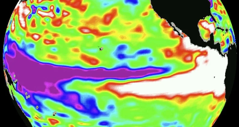
Let’s break down this atmospheric cocktail. We’ve got La Niña, that familiar chill in the tropical Pacific waters, flexing its muscles again. This oceanic phenomenon is notorious for rejigging our jet stream, that river of air high above us that dictates storm tracks and temperature patterns. This year, La Niña is nudging that jet stream in a way that’s bad news for spring warmth across a good chunk of North America.
La Niña’s Chilly Handshake:
As our insightful weather models are showing, La Niña is expected to usher in a familiar pattern: colder, stormier conditions for the northern and northwestern United States, extending its snowy hand deep into southern Canada. Conversely, the southern tier of the US is likely to experience a milder, drier spring – a tale of two Americas, weather-wise.
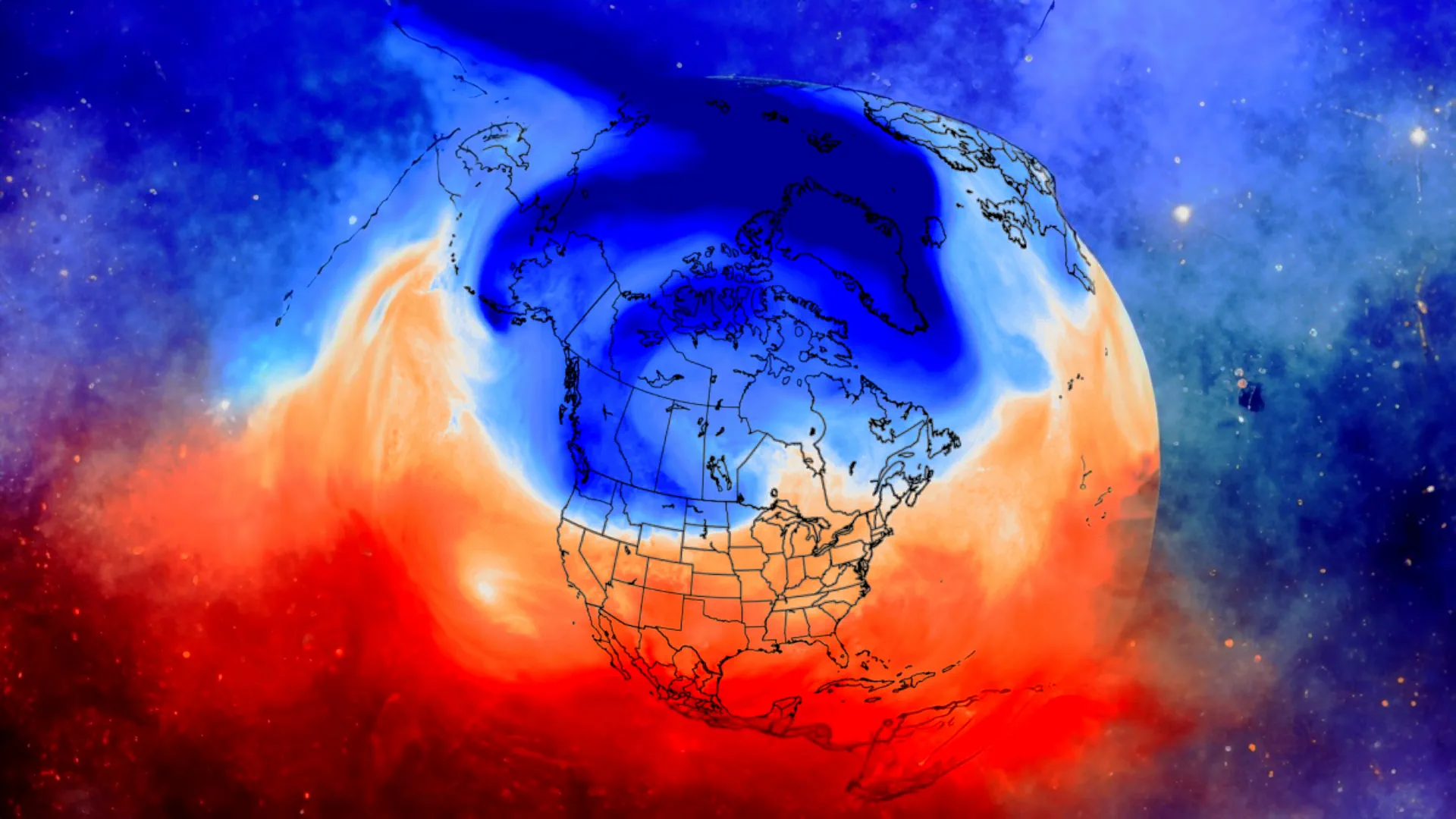
And speaking of chilly hands, let’s talk about the Polar Vortex. This swirling mass of frigid air high above the Arctic is usually content to stay put way up north. But lately, it’s been showing signs of wandering south, and our data suggests it’s aiming for eastern Canada and the northeastern United States as we head deeper into February and March.
February: Winter’s Icy Finale – or is it just Intermission?
February is shaping up to be a key month in this snowy saga. Mid-month forecasts are flashing red – or should we say white? – for a significant cold air outbreak blasting across the US and southern Canada. This isn’t just your run-of-the-mill cold snap; we’re talking about a Polar Vortex-influenced chill that could send temperatures plummeting and snowfall totals soaring.
Models paint a picture of a broad band of snowfall, stretching from the Midwest, across the Northeast, and deep into southeastern Canada. Even areas further west and south, including parts of the central Plains, Texas, and Oklahoma, could see a dusting or more. While we always caution against relying on single model runs, the consistency across both US and European models is certainly raising eyebrows – and snowfall expectations.
As February progresses, the Polar Vortex influence isn’t expected to wane. Stratospheric pressure forecasts indicate this vortex may be displaced right over eastern Canada and the eastern US, further amplifying the northerly flow and keeping the chill on. This translates to a continued snowfall threat for the northwestern US, the Midwest, and the Northeast as we approach the end of February and the official start of Spring.
March: Spring Forward, Snow Fall Back?
Just when you thought you could swap out your snow shovel for gardening tools, March arrives with a potentially snowy surprise. Mid-March pressure patterns hint at that classic La Niña high-pressure system in the North Pacific, coupled with the Polar Vortex stubbornly parked over Canada. This sets up a scenario where colder air pools over western Canada, ready to be funneled southward into the United States.
While the southern US and East Coast may experience an early taste of spring warmth, the forecast maps are hinting at colder-than-normal temperatures persisting across the western and northeastern United States, the Midwest, and western Canada. This means the snow potential isn’t disappearing with the calendar flip to March.
Long-range models are indeed suggesting above-average snowfall for March across the northern United States and Canada. While monthly averages can be broad strokes, ensemble forecasts are hinting at localized snowfall surges in mid-March, particularly over the western US, Midwest, and Northeast. We’re seeing some model discrepancies, but the overall trend leans towards continued snowy conditions in these regions.
April: A Lingering Winter Whisper?
Looking even further ahead to April, long-range models are offering some intriguing – and for some, perhaps unwelcome – hints. Initial April forecasts from leading models like ECMWF and UKMO are suggesting above-normal snowfall clinging on across the northern US, the upper Midwest, and even the Northeast. La Niña’s lingering influence seems to be extending the snowfall season further than usual in these areas.
While the southern US is rightly expected to see less snowfall as we move deeper into spring, the models are pointing to a potentially extended snow season for the northern tier of the country.
The Official Word:
Corroborating these model trends, the official February-April outlook from the Climate Prediction Center (CPC) echoes this snowy sentiment. They are forecasting equal to higher chances of colder temperatures across the northern United States, while the southern half and the East Coast lean towards warmer conditions.
Crucially, the CPC’s precipitation outlook also aligns, showing an equal to higher probability of increased precipitation across the eastern United States, the Ohio Valley, and the Pacific Northwest – regions pinpointed by models for potential snowfall.
The Bottom Line: Get Ready for a Potentially Snowy Spring
So, there you have it folks. This spring across the US and Canada is shaping up to be anything but predictable. While some regions, particularly the South, might enjoy an early spring thaw, large parts of the northern United States, the Midwest, the Northeast, and southern Canada are bracing for a continued, and potentially amplified, snowy ride thanks to the dynamic duo of La Niña and a wandering Polar Vortex.
Here’s the regional snapshot:
Northeast & Midwest: High chance of above-average snowfall throughout February, March, and potentially even into April. Expect colder temperatures and continued winter conditions.
Northern US (Rockies, Pacific Northwest): Elevated snowfall potential, especially in higher elevations. Colder than average temperatures likely.
Central US (Plains): Variable conditions. Potential for snowfall events, particularly in February and early March, but temperature swings possible.
Southern US: Milder and drier conditions expected overall. Snowfall unlikely except for perhaps a brief dusting in the northernmost parts of the region.
Canada (Southern Regions): Significant snowfall potential, particularly in southeastern Canada, aligning with the Northeast US patterns. Colder than average temperatures expected.
Stay Tuned!
This is, of course, a long-range outlook, and the atmosphere can be fickle. We’ll be keeping a close eye on these developing patterns and bringing you updates as we move closer to Spring 2025. For now, if you’re in those potentially snowy zones, maybe hold off on swapping out the snow tires just yet. Mother Nature might have a few more wintery verses left to sing in her spring symphony!

Gleb Perov is the founder and chief meteorologist of POGODNIK, a leading weather forecasting service in Eastern Europe. With over 15 years of hands-on experience in meteorology and climate analysis, he has worked private weather services.
Gleb is the author of numerous scientific and analytical publications on climate, magnetic storms, and atmospheric processes. He regularly collaborates with major international agencies such as NOAA, ECMWF.


