Tropical Storm Dianne Threatens to Unleash Chaos Across Australia – Are You Ready for the Worst

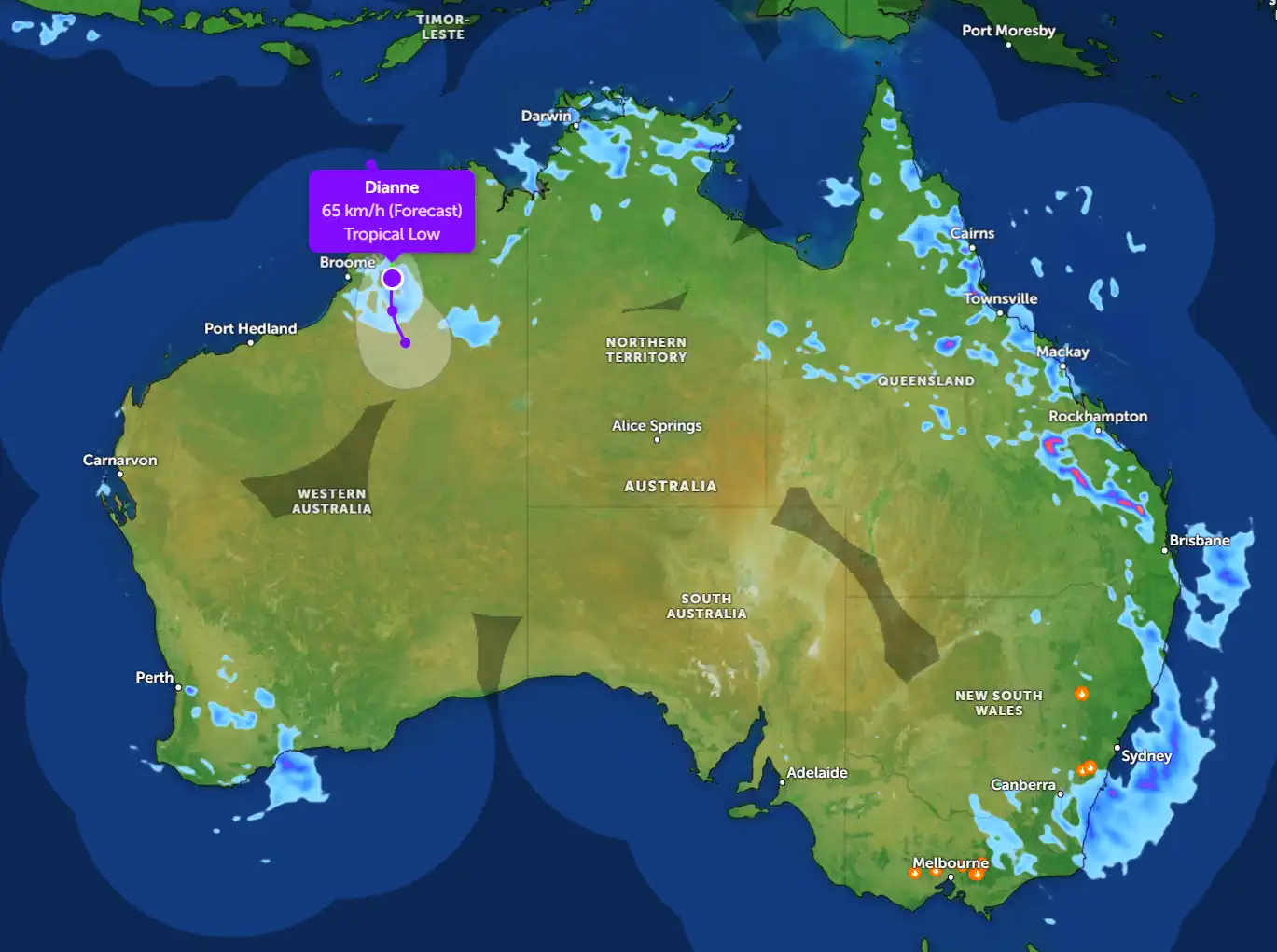
Update on Tropical Storm Dianne, which is currently brewing off the northern coast of Australia. This powerful weather system, classified as a Tropical Low with a 65% chance of intensifying into a cyclone, is poised to impact several regions across the country, particularly in the Northern Territory and parts of Western Australia. With winds already reaching speeds of 65 km/h, Dianne is a force to be reckoned with, and residents need to brace themselves for what could be a turbulent few days ahead.
Where Is Tropical Storm Dianne Right Now?
As of this morning, March 29, 2025, Tropical Storm Dianne is positioned just off the coast of the Northern Territory, near Broome, with its center approximately 200 kilometers northwest of the town. The storm's current trajectory shows it moving slowly southeast, with a projected path that could bring it closer to land over the next 48 to 72 hours. The system is drawing energy from the warm waters of the Timor Sea, which are fueling its potential to strengthen into a full-blown cyclone. For now, it remains a Tropical Low, but the Bureau of Meteorology (BOM) has issued a cyclone watch for coastal areas between Port Hedland and Broome, with warnings extending as far east as Darwin.
What Can Australians Expect?
The immediate concern for residents in the Northern Territory and Western Australia is the heavy rainfall and strong winds that Dianne is already bringing to the region. Broome and surrounding areas are expected to see rainfall totals of 100 to 150 mm over the next two days, with some isolated areas potentially receiving up to 200 mm. This deluge could lead to flash flooding, particularly in low-lying areas and along river systems like the Fitzroy River, which has a history of overflowing during intense wet season storms.
In addition to the rain, wind gusts of up to 80 km/h are forecast for coastal communities, with the potential for even stronger winds if Dianne intensifies. These winds could cause significant damage to infrastructure, down power lines, and uproot trees, posing a serious risk to both property and personal safety. Residents in the affected areas should secure loose outdoor items, such as patio furniture and garden tools, to minimize the risk of flying debris.
The Bigger Picture: A National Impact
While the most immediate impacts will be felt in the northwest, Tropical Storm Dianne's influence is expected to extend far beyond the Northern Territory. As the system moves southeast, it will interact with a high-pressure system over central Australia, potentially steering moisture-laden clouds toward Queensland and even parts of New South Wales. This could bring heavy rain to cities like Cairns, Townsville, and Mackay, where rainfall totals of 50 to 100 mm are possible by mid-week. The east coast, already saturated from recent wet weather, may see renewed flooding risks, particularly in areas still recovering from earlier storms this season.
Further south, cities like Brisbane, Sydney, and even Melbourne could experience indirect effects, including increased humidity and the potential for scattered thunderstorms. While these areas are not in the direct path of the storm, the ripple effects of Dianne's moisture could lead to unsettled weather patterns across southeastern Australia. Adelaide and Perth, meanwhile, are likely to remain relatively dry, though Perth may see some light showers as the storm's outer bands brush the region.
The Forecast: Will Dianne Become a Cyclone?
The million-dollar question on everyone's mind is whether Tropical Storm Dianne will escalate into a cyclone. As of now, the BOM gives it a 65% chance of reaching cyclone status within the next 48 hours. For this to happen, Dianne would need to sustain winds of at least 63 km/h (the threshold for a Category 1 cyclone) and develop a more defined eye structure. The warm sea surface temperatures in the Timor Sea—currently around 29°C—provide the perfect conditions for intensification, but there are a few factors that could hinder its growth.
One such factor is wind shear, which is currently moderate in the region. If wind shear increases, it could disrupt the storm's organization and prevent it from reaching cyclone strength. On the other hand, if Dianne moves into an area of lower shear, it could rapidly intensify, potentially reaching Category 2 or higher. Residents in the cyclone watch zone should monitor updates closely, as the situation could change quickly.
How to Prepare for Tropical Storm Dianne
For those in the path of Tropical Storm Dianne, preparation is key. Here are some steps you can take to ensure your safety:
Stock Up on Essentials: Make sure you have enough food, water, and medical supplies to last at least 72 hours.
Cyclone Alfred's Coming: Brisbane's Drowning and Surfers Are Chasing Killer Waves 2025
Founder and chief forecaster of the Pogodnik service. He has many years of experience in the meteorological service. He is the author of numerous scientific publications and popular articles about the weather.


