Arctic Blast Unleashes Chaos: Canada Faces a Crippling Snow on March 31, 2025

Ottawa, Canada – March 29, 2025 – A formidable weather system is barreling toward Canada, poised to deliver a punishing blow as March draws to a close. Meteorologists are sounding the alarm for a colossal snowstorm set to strike on March 31, 2025, driven by a potent Arctic blast that will plunge the nation into a deep freeze. With heavy snow, biting winds, and treacherous conditions on the horizon, this storm threatens to disrupt life across multiple provinces, from the Prairies to the Atlantic coast.
The latest meteorological charts reveal a sprawling low-pressure system descending from the northwest, fueled by a frigid polar vortex that has dislodged from the Arctic. This system is expected to deepen as it interacts with a secondary cyclonic disturbance forming over the Great Lakes, creating a textbook setup for a nor'easter-like event. The clash of this bitterly cold air mass with a moist frontal boundary pulling in from the south will set the stage for widespread heavy snowfall, with some regions facing near-blizzard conditions.
Snow Forecast CA
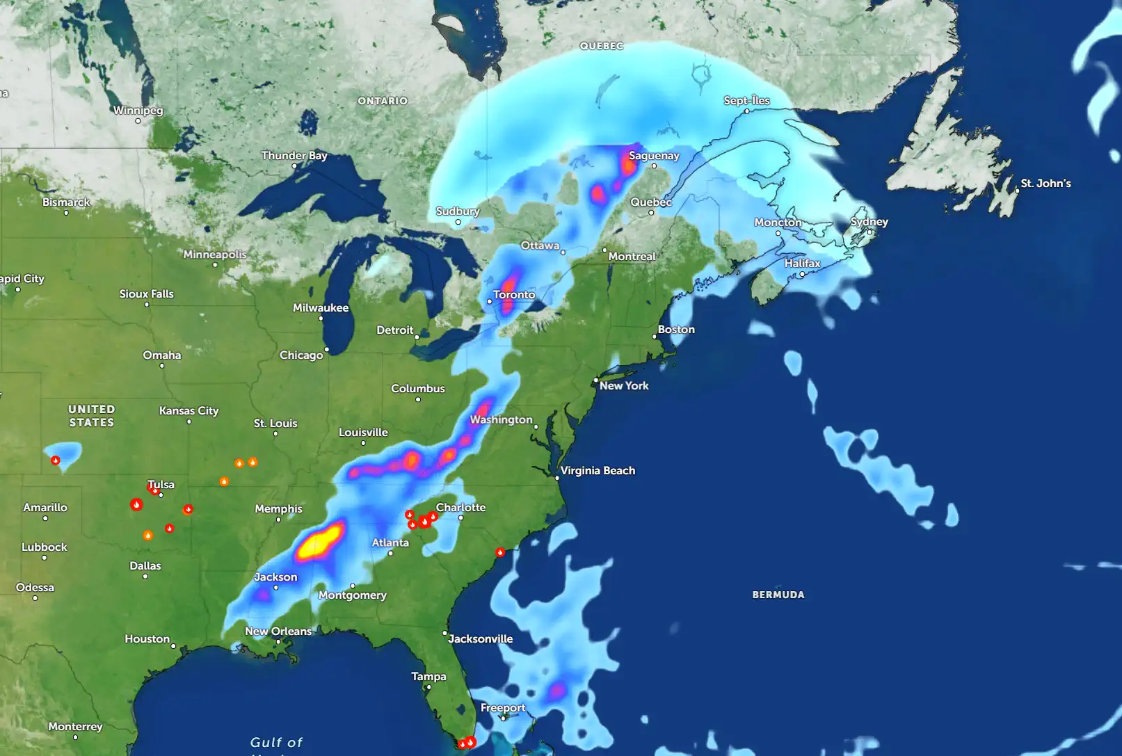
In Ontario, the forecast is particularly grim for cities like Toronto, Ottawa, and Sudbury, which lie directly in the storm's crosshairs. The weather map highlights a swath of deep indigo and violet hues over these areas, signaling intense snowfall rates of 3 to 5 centimeters per hour during the storm's peak. Toronto could see accumulations of 35 to 45 centimeters, while Ottawa may be buried under 50 to 60 centimeters of snow. Gusty winds, reaching speeds of 70 kilometers per hour, will whip the snow into a frenzy, reducing visibility to near zero and creating hazardous whiteout conditions on major highways like the 401 and 417.
Moving eastward, Quebec is bracing for the storm's most ferocious impacts. Montreal and Quebec City are under a severe weather threat, with the map showing a concentrated band of crimson and purple shading, indicative of extreme snowfall. These areas could see 70 to 90 centimeters of snow, with isolated pockets near the St. Lawrence Valley potentially exceeding 1 meter. The storm's intensity will be amplified by a tight pressure gradient, driving sustained winds of 50 to 60 kilometers per hour and creating full-blown blizzard conditions. Residents are being warned to prepare for extended power outages, as the weight of the snow and high winds could bring down power lines and tree branches.
The Atlantic provinces are also in for a significant wallop as the storm tracks eastward. Halifax, Sydney, and St. John's are expected to experience a prolonged period of heavy snow, with accumulations ranging from 45 to 65 centimeters. The map shows the system intensifying over the Atlantic, drawing in additional moisture and creating a messy mix of precipitation along the coast. While some areas may briefly see sleet or freezing rain, the dominant precipitation type will be snow, driven by a reinforcing surge of cold air. Coastal regions, particularly in Newfoundland, face the added threat of storm surges, with wave heights potentially reaching 5 to 7 meters, posing risks to low-lying areas.
In the Prairies, Winnipeg and Thunder Bay are not escaping the storm's wrath. The map indicates lighter snowfall totals of 20 to 30 centimeters, but the real danger lies in the extreme cold that will follow. A high-pressure ridge building in behind the storm will usher in an Arctic air mass, sending wind chills plummeting to -35°C or lower. This bone-chilling cold, combined with moderate snow and gusty winds, will create a multi-faceted hazard, with the potential for frostbite and hypothermia for anyone exposed to the elements for extended periods.
The meteorological setup behind this storm is a classic example of a mid-latitude cyclone amplified by a strong jet stream. A pronounced upper-level trough is digging deep into central Canada, allowing Arctic air to spill southward. At the same time, a surface low is undergoing rapid cyclogenesis over the Great Lakes, drawing in moisture from the Gulf of Mexico via a warm conveyor belt. This unusual influx of moisture for late March is what's driving the storm's potential for such heavy snowfall, a phenomenon that some climatologists attribute to shifting weather patterns influenced by a warming climate.
Preparation is critical as the storm approaches. Environment Canada has issued a slew of winter storm warnings and blizzard watches, urging residents to take proactive measures. Stocking up on non-perishable food, water, and emergency supplies is strongly recommended, as the storm could isolate communities and disrupt supply chains for several days. In major urban centers like Toronto and Montreal, transit authorities are preparing for widespread delays and cancellations, while snowplows and salt trucks are being mobilized to combat the expected deluge of snow. Rural areas face even greater risks, with the potential for impassable roads and prolonged power outages in subzero temperatures.
The economic toll of the storm could be substantial. With key economic hubs like Toronto, Montreal, and Halifax facing significant disruptions, businesses may be forced to shutter, and air travel is likely to grind to a halt. The cost of snow removal, infrastructure repairs, and lost productivity could climb into the tens of millions, placing additional strain on municipal budgets already stretched thin by a challenging winter season.
As the storm looms, meteorologists are emphasizing the importance of staying informed and taking precautions. “This is a high-impact weather event that demands respect,” said lead forecaster Dr. Michael Bennett. “We're looking at a storm that could bring parts of Canada to a standstill. If you can stay off the roads and remain indoors, that's the safest course of action.”
For now, Canadians are keeping a wary eye on the skies, knowing that the Arctic blast of March 31, 2025, could go down in history as one of the most disruptive storms of the decade. From Ontario to the Maritimes, the message is clear: prepare now, because this storm is set to unleash chaos on an unprecedented scale.
Summer 2025 Weather Forecast for the U.S. and Canada
Founder and chief forecaster of the Pogodnik service. He has many years of experience in the meteorological service. He is the author of numerous scientific publications and popular articles about the weather.


