“Storm of the century”: Storm Darragh threatens Ireland and the UK with hurricane-force winds and power outages

Forecast for the coming days
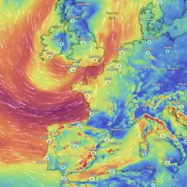
Storm Daragh, jointly named by the UK Met Office, Met Éireann and the Dutch KNMI, will begin its destructive impact on Ireland and the UK from the evening of Friday, December 6, and will last until Saturday, December 7. This powerful cyclone is the fourth of the 2024/25 season, following Bert, which caused catastrophic flooding in November. Daragh will bring less rain than its predecessor, but will make up for it with gale-force winds.
What do forecasters predict?
Wind speed:
Up to 130 km/h (80 mph) on the coasts of Ireland and western Britain.
Inland areas could experience gusts of up to 115 km/h (70 mph).
Rain:
Heavy rainfall of up to 60 mm (2.5 in) is expected in Ireland and Scotland, with the risk of localised flooding.
Yellow warnings for rainfall are in place for northern Ireland.
Marine conditions: Dangerous waves along the coasts could exceed 10 metres, posing a threat to shipping and coastal areas.


Which regions are at risk?
Ireland:
The strongest winds are expected in the western and northwestern counties.
Yellow and orange wind warnings apply to the whole country.
United Kingdom:
The coastal areas of Northern Ireland, Scotland, Wales and the southwest of England will be particularly affected.
The impact will be felt until Saturday evening, especially in areas with orange warnings.
Marine routes:
Conditions are hazardous for shipping, particularly in the Irish Sea and North Atlantic.
Before the storm:
Secure outdoor items such as bins, garden furniture and children's toys.
Charge devices and stock up on water and food in case of power outages.
During the storm:
Avoid travelling in warning areas, especially at night.
Stay away from the coast due to the risk of huge waves.
Beware of debris, fallen trees and downed power lines.
Expert comments
Liz Coleman, deputy chief executive of Met Éireann, said:
"We urge residents to be prepared. Strong winds could cause trees to fall, structures to collapse and power outages. If you are planning to travel, please exercise caution." Jason Kelly, chief meteorologist at the Met Office, added:
"This is a complex system that will bring a range of threats, from gale-force winds to localised flooding. We continue to monitor developments."
What to expect next?
After Storm Darragh passes, forecasters are predicting continued unsettled weather with alternating rain and winds. Temperatures will rise to 10-13°C, but the overall situation will remain volatile.
Be prepared and stay safe! Storm Daragh will be a major test of winter 2024.
Founder and chief forecaster of the Pogodnik service. He has many years of experience in the meteorological service. He is the author of numerous scientific publications and popular articles about the weather.


