![]()
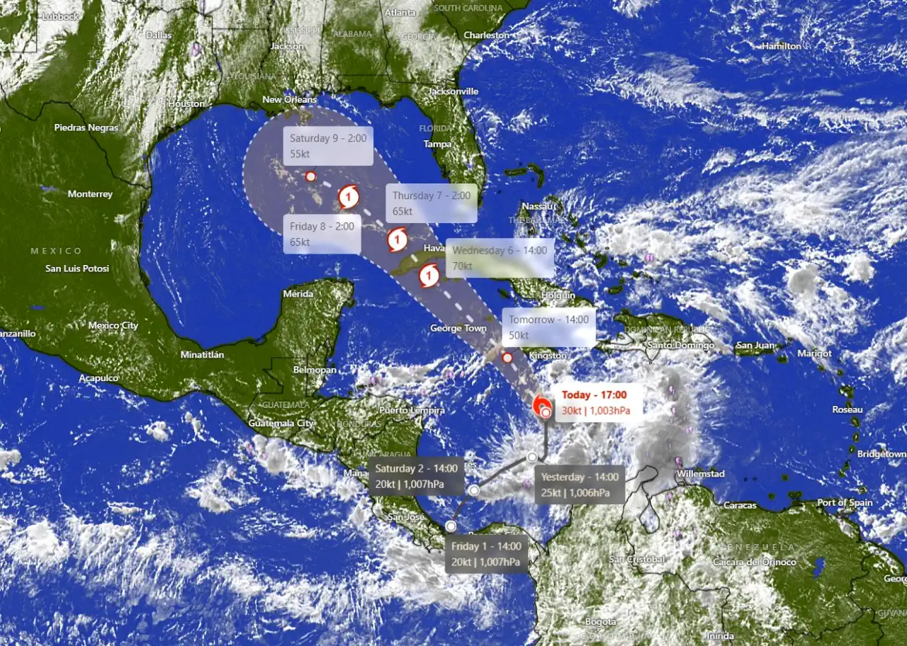
As the Atlantic hurricane season reaches its final weeks, Tropical Depression Eighteen has stirred concerns across the Caribbean and the Gulf Coast. Situated over warm Caribbean waters, this system is expected to intensify and may evolve into Tropical Storm Rafael in the coming days. The National Hurricane Center (NHC) has noted that the depression is likely to strengthen, with environmental conditions supporting tropical development.
Whether this system impacts Florida depends largely on atmospheric conditions and the position of the jet stream, which could play a pivotal role in guiding its trajectory.
Meteorologists expect steady strengthening, with Tropical Depression Eighteen anticipated to escalate to tropical storm status by late today and potentially develop into a hurricane by Wednesday. The tropical system could draw enough energy from warm waters and relatively low wind shear conditions in the Caribbean, fueling its intensification over the next few days.
The future path of Tropical Depression Eighteen depends on interactions with the jet stream. AccuWeather meteorologist Bernie Rayno explains that if a dip in the jet stream moves eastward, it could capture the tropical system, steering it across the southeastern Gulf of Mexico toward South Florida. However, if the jet stream remains farther west, the system could drift into the central or western Gulf, putting areas such as Louisiana and Texas at risk. There is also a chance that it will continue due westward, losing strength as it approaches southern Mexico.
Wind
- Jamaica: Tropical storm conditions are expected by tonight.
- Cayman Islands: Hurricane conditions are anticipated by Tuesday afternoon.
- Western Cuba and Isle of Youth: Hurricane conditions are possible by Wednesday, with central Cuba potentially experiencing tropical storm conditions on the same day.
The western Caribbean is expected to see heavy rainfall, with Jamaica and Cuba bearing the brunt of precipitation totals. Rainfall is expected to range from 3 to 6 inches, with localized amounts up to 9 inches, which may lead to flooding and mudslides in vulnerable areas. Rainfall could extend into Florida and the southeastern U.S. by late week, bringing further risk of flooding.
Storm Surge
Minor coastal flooding may occur in Jamaica tonight, while the Cayman Islands could experience surge conditions on Tuesday. Coastal areas in southern Cuba, especially Pinar del Rio and the Isle of Youth, may see a rise in water levels of 2 to 4 feet above normal, depending on local onshore winds.
The tropical system will generate swells, affecting much of the western Caribbean coastline over the next few days, leading to rough surf and dangerous rip currents.
Authorities have issued watches and warnings to prepare for possible impacts:
While Florida remains outside the watch and warning zones, residents are encouraged to stay updated as conditions develop. The possibility of tropical storm impacts in Florida or the Gulf Coast may become clearer as the system advances and interacts with the jet stream.
With significant factors still in play, the trajectory and intensity of this system will be closely monitored. The NHC will issue updates as new information becomes available.
