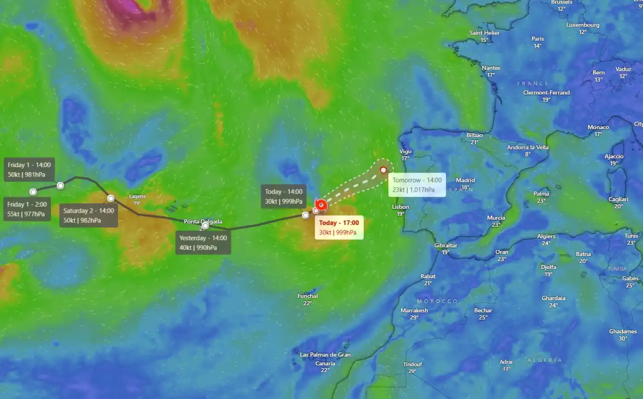
Subtropical Storm “Patty” Impacting the Azores

Subtropical Storm "Patty" formed over the northern Atlantic on Saturday, November 2, 2024, at 09:00 UTC, bringing adverse weather conditions to the Azores. Shortly after its formation, the Azores Meteorological Service issued Tropical Storm Warnings for all islands in the archipelago.
The storm's minimum central pressure stood at 982 hPa, with sustained winds of 66 km/h (40 mph) extending outward up to 330 km (205 miles) from its center. This broad wind field contributed to the storm's expansive impacts over the region.
Progression Toward the Azores
By 21:00 UTC on November 2, "Patty" drew closer to the Azores, intensifying its impact with maximum sustained winds of 100 km/h (65 mph). By early Sunday, November 3, at 03:00 UTC, the storm's center was located around 115 km (75 miles) south-southwest of Lajes, Azores, with maximum sustained winds slightly decreasing to 95 km/h (60 mph) as it shifted eastward at 31 km/h (20 mph).
At 09:00 UTC, Patty's center neared São Miguel Island, the largest and most densely populated island in the Azores, home to approximately 140,000 residents.
Forecast and Impacts
Forecast models suggest that Subtropical Storm "Patty" will continue to move east-northeast, gradually approaching the southeastern Azores. The system's intensity has decreased to 85 km/h (50 mph) in maximum sustained winds, though occasional stronger gusts may persist.
Meteorologists anticipate that "Patty" will continue weakening and transition into a post-tropical system by early Monday, with the storm dissipating by midweek. As it weakens, the severity of its impact on the Azores should gradually reduce.
Subtropical Storm “Patty” forecast track at 09:00 UTC on November 3, 2024. Image credit: NHC
Currently, tropical-storm-force winds, around 65 km/h (40 mph), extend outward up to 280 km (175 miles) from the center, particularly affecting the storm's southern and southwestern quadrants. Patty's minimum central pressure is now estimated at 989 hPa.
Expected Weather Conditions
- Wind: Tropical storm-force winds are forecast to affect parts of the Azores, with potentially hazardous gusts.
- Rainfall: Accumulations across the islands may reach 25–50 mm (1–2 inches), with localized areas possibly seeing up to 100 mm (4 inches) through early Monday, potentially leading to minor flooding.
- Ocean Conditions: Swells generated by Patty are expected to bring hazardous surf and dangerous rip currents through tonight.
As the remnants of "Patty" continue eastward, residents of the Azores are advised to stay updated on local warnings. Additionally, weakened remnants are expected to reach northern Portugal and Spain by Tuesday, November 5, with minor impacts expected in these regions.