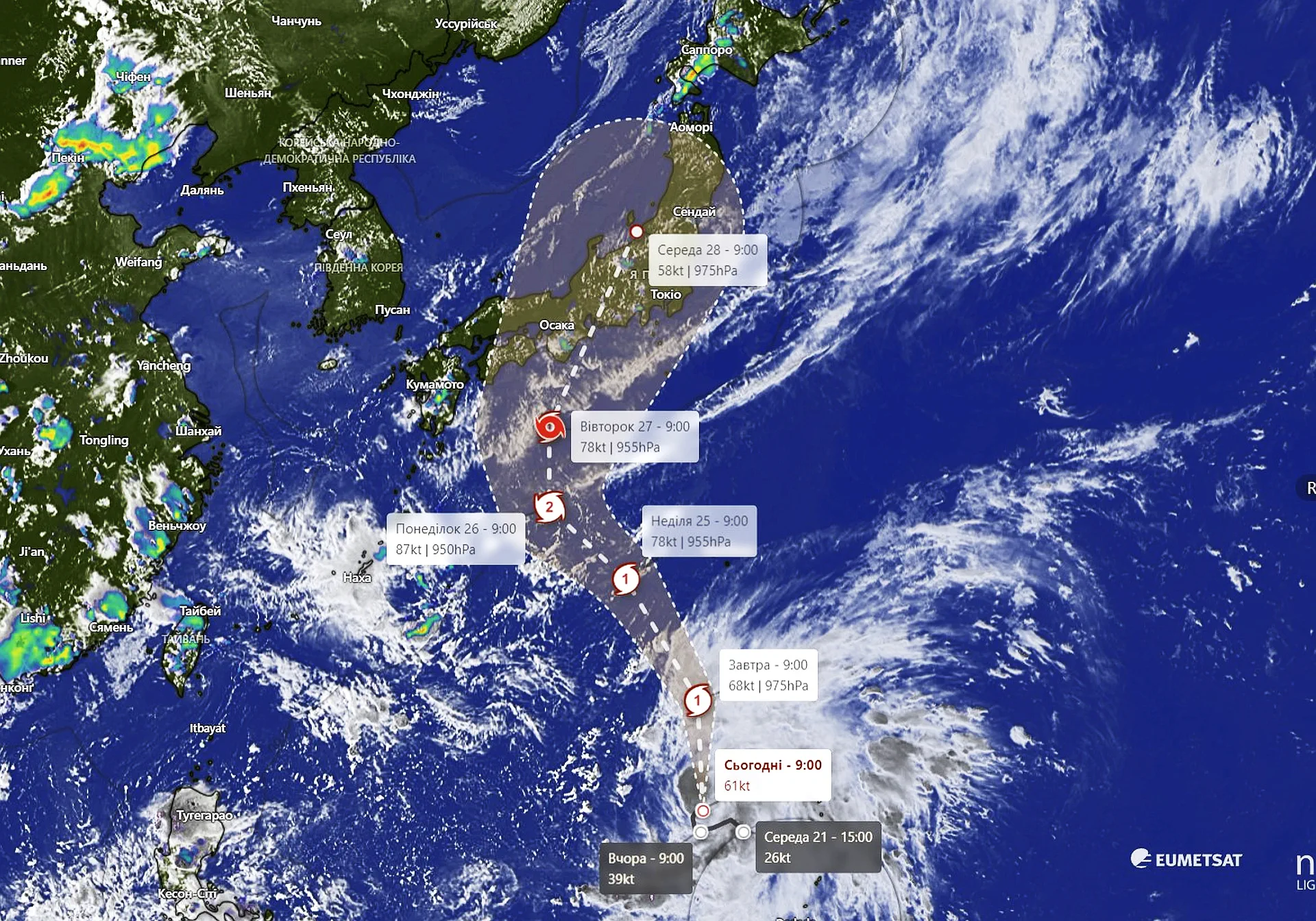

Cyclone Shanshan: A Threat to Japan
Cyclone Shanshan is intensifying and heading towards Japan, posing a significant threat to the country. This powerful tropical cyclone is expected to bring strong winds, heavy rainfall, and the potential for flooding and landslides.
Key Points:
Intensifying Storm: Cyclone Shanshan is gaining strength as it moves closer to Japan.
Heavy Rainfall: The cyclone is expected to bring significant amounts of rainfall, increasing the risk of flooding in vulnerable areas.
Strong Winds: Powerful winds could cause damage to infrastructure, uproot trees, and disrupt power supplies.
Landslide Risk: The combination of heavy rainfall and steep slopes could lead to landslides in mountainous regions.
Preparations:
Stay Informed: Monitor weather updates closely and follow the advice of local authorities.
Prepare for Evacuation: If necessary, be prepared to evacuate your home to a safer location.
Secure Property: Secure loose objects outside, such as furniture and potted plants.
Stock Up on Supplies: Have a supply of food, water, and essential items in case of power outages or disruptions.
Cyclone Shanshan: A Closer Look
Cyclone Shanshan is a powerful tropical cyclone that is expected to make landfall in Japan. Here's a more detailed breakdown of its potential impacts:
Storm Intensity:
- Category: Based on current projections, Cyclone Shanshan is expected to reach typhoon strength, potentially reaching Category 3 or higher on the Saffir-Simpson Hurricane Wind Scale.
- Wind Speeds: Typhoon-force winds can cause significant damage to infrastructure, uproot trees, and generate dangerous storm surges.
Rainfall and Flooding:
- Heavy Rainfall: The cyclone is expected to bring torrential rains, leading to potential flooding in low-lying areas and along river basins.
- Landslides: The combination of heavy rainfall and steep slopes could trigger landslides, especially in mountainous regions.
Storm Surge:
- Coastal Flooding: The storm surge generated by Cyclone Shanshan could lead to coastal flooding, particularly in areas with low-lying coastlines.
Impact on Japan:
- Infrastructure Damage: The strong winds and heavy rainfall associated with the cyclone could cause widespread damage to infrastructure, including roads, bridges, and power lines.
- Disruptions: The storm could disrupt transportation, communication services, and daily life in affected areas.
- Casualties: There is a risk of injuries or fatalities due to the severe weather conditions.
It's important to note that the exact intensity and track of Cyclone Shanshan may change as it approaches Japan. Stay updated with the latest information from local weather services and authorities.
Typhoon Shanshan Slows Down as It Nears Japan, Landfall Expected in Kyushu on August 29