
Snow in Europe, weak polar vortex point to cold winter 2024-2025
As winter approaches, meteorologists are closely watching the key factors that shape seasonal weather patterns. Recent studies highlight that the extent of October snow cover over the Northern Hemisphere has a notable effect on the Polar Vortex, influencing winter conditions across North America and Europe. Here, we explore how October's snow cover indirectly affects the Polar Vortex and, subsequently, weather patterns, potentially leading to colder and snowier winters.
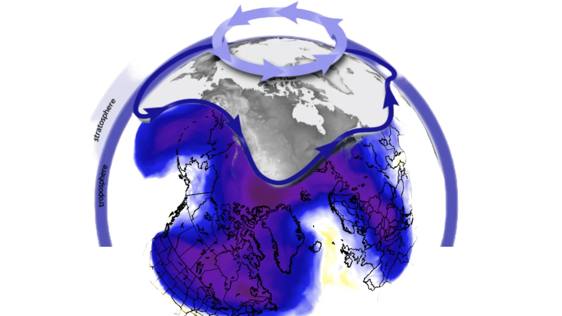
The Polar Vortex
The Polar Vortex is a massive cyclonic circulation that develops over the North Pole and extends into the Stratosphere, reaching altitudes of up to 50 km (31 miles). As the Sun's angle lowers in the autumn, the polar regions cool more rapidly than the mid-latitudes, creating a stark temperature and pressure contrast. This difference results in the formation of a low-pressure system known as the Polar Vortex, which typically locks cold air around the polar regions.
A strong Polar Vortex generally maintains the colder air in the Arctic, resulting in milder winters for the mid-latitudes. Conversely, a weakened Polar Vortex allows the cold air to escape southward, affecting the United States, Canada, and Europe with more severe winter weather.
October snow cover in the Northern Hemisphere, particularly across Siberia, has a long-term effect on the Polar Vortex. Research shows that a larger-than-average snow cover during this month can weaken the Stratospheric Polar Vortex.
- Increased Snow Cover and High Pressure: As snow accumulates, it reflects more sunlight, cooling the surface. This cooling effect promotes the formation of high-pressure systems over Siberia.
- Vertical Energy Transfer: The stronger high-pressure systems push energy vertically into the Stratosphere, disrupting the Polar Vortex by weakening its circulation.
- Polar Vortex Weakening and Weather Impact: A weaker vortex struggles to contain the cold air, which then flows southward, leading to more frequent cold outbreaks and potentially higher snowfall in the mid-latitudes.
Current Snow Extent and 2024/2025 Winter Outlook
Data for October 2024 indicates that snow cover in Eurasia is already above average. According to the latest observations from the Canadian Cryosphere Agency, snow coverage is in the top three for this time of year over the last two decades, suggesting a high likelihood of increased vertical energy impacting the Stratosphere and, consequently, the Polar Vortex.
Forecast models are projecting further snow accumulation in the coming weeks, especially over Siberia. This pattern is expected to drive the formation of a robust high-pressure system, which could lead to a significant weakening of the Polar Vortex. If this trend continues, it could set the stage for colder winter conditions across North America and Europe, including the possibility of a Sudden Stratospheric Warming (SSW) event.
Sudden Stratospheric Warming and Its Effects
An SSW occurs when there is an abrupt increase in Stratospheric temperatures, often resulting in a collapse of the Polar Vortex. Following an SSW, cold air is typically displaced southward, impacting weather patterns significantly. Historical data indicates that after SSW events, regions like the eastern United States and Europe experience colder-than-average temperatures and increased snowfall.
What This Means for Winter 2024/2025
The expanding October snow cover in the Northern Hemisphere suggests that the upcoming winter could feature more disrupted weather patterns due to a weakened Polar Vortex. We may see increased cold air outbreaks and more snowfall in the mid-latitudes, particularly in the United States, Canada, and Europe. Meteorologists will continue to monitor snow extent and Polar Vortex activity closely, as they are critical indicators for winter weather forecasts.