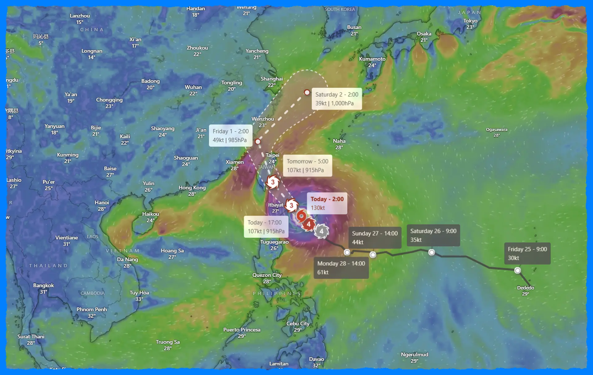
As Typhoon "Kong-rey" approaches Taiwan, it is rapidly intensifying and raising significant concerns among meteorologists and residents in the region. Currently located approximately 1,040 kilometers southeast of Taipei, Taiwan, Kong-rey has sustained winds reaching 148 km/h (92 mph) and is moving west-northwest at 13 km/h (8 mph). The forecast suggests a potential landfall on Taiwan's southeastern coast within the next 48 to 60 hours, with the possibility of a westward shift that could lead to a direct hit on the Batanes Islands in the Philippines.
Recent satellite images reveal that Typhoon Kong-rey is experiencing rapid intensification, characterized by improved organization and the development of a large, ragged eye. The Joint Typhoon Warning Center (JTWC) has noted that environmental conditions are highly favorable for further strengthening. With low vertical wind shear and warm sea surface temperatures ranging from 29 to 30 °C (84 to 86 °F), Kong-rey could reach super typhoon status shortly before its expected landfall.
Weather models show consensus on Kong-rey maintaining its northwestern trajectory, driven by a subtropical ridge located to the east and northeast. However, the storm is likely to lose some strength after making landfall due to interactions with Taiwan's terrain. Forecasts indicate that wind speeds could decrease to approximately 120 km/h (75 mph) as Kong-rey passes through the Taiwan Strait, before transitioning into an extratropical system when encountering cooler waters and increased wind shear over the East China Sea.
The Philippine Atmospheric, Geophysical and Astronomical Services Administration (PAGASA) has issued public advisories, emphasizing significant hazards for both Taiwan and the Philippines. Communities in northern Luzon, particularly in Batanes and the Babuyan Islands, are under heightened alert, with the potential for Wind Signal No. 3 or 4 being issued, depending on the storm's exact track. This could lead to serious wind impacts, including gale-force winds.
In addition to strong winds, the risk of life-threatening storm surges is notable. Low-lying coastal areas in Batanes and Babuyan Islands could face moderate to high storm surge risks, prompting PAGASA to advise all vessels to remain in port or seek safe harbor. Current forecasts estimate wave heights could range from 4.5 meters (15 feet) to 10 meters (33 feet) along various coastlines, creating hazardous maritime conditions.
As Kong-rey approaches, communities in the affected areas are urged to prepare for severe weather conditions. This includes securing properties, staying informed through official channels, and having emergency plans in place. Gusty conditions are expected across much of Luzon, including Metro Manila and the CALABARZON region, which will likely face tropical storm to near-typhoon force winds.
Residents should remain vigilant and monitor updates from local authorities, as forecasts may change depending on the storm's behavior in the coming days. The threat posed by Kong-rey is a stark reminder of the potential dangers of tropical storms, underscoring the importance of preparedness and community resilience.
Typhoon Kong-rey's rapid intensification is a cause for concern, with the potential to bring severe weather to Taiwan and the northern Philippines. As atmospheric conditions remain favorable for further strengthening, it is crucial for residents in the forecast path to remain updated and prepared for the possible impacts in the coming days. With authorities actively monitoring and issuing warnings, staying informed is key to ensuring safety as Kong-rey makes its approach.